Dynamic monitoring of urban black-odor water bodies based on GF-2 image
HU Guoqing1(), CHEN Donghua1,2, LIU Congfang3, XIE Yimei1, LIU Saisai2, LI Hu1()
1. College of Geography and Tourism, Anhui Normal University, Wuhu 241000, China 2. College of Computer and Information Engineering, Chuzhou University, Chuzhou 239000, China 3. College of Geography Science and Tourism,Xinjiang Normal University, Urumqi 830001, China
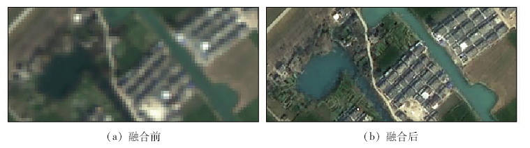
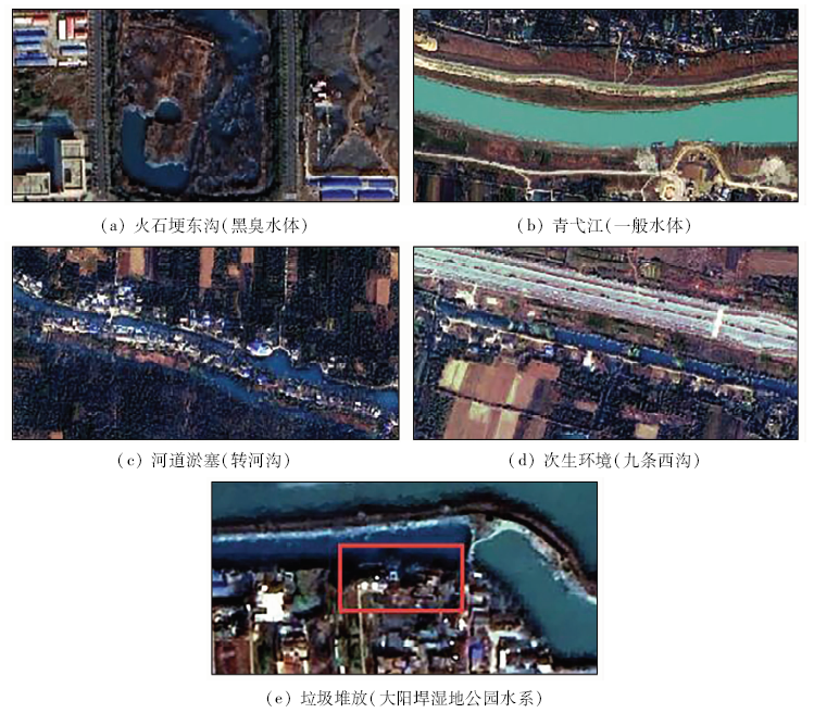
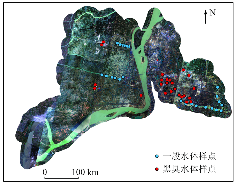
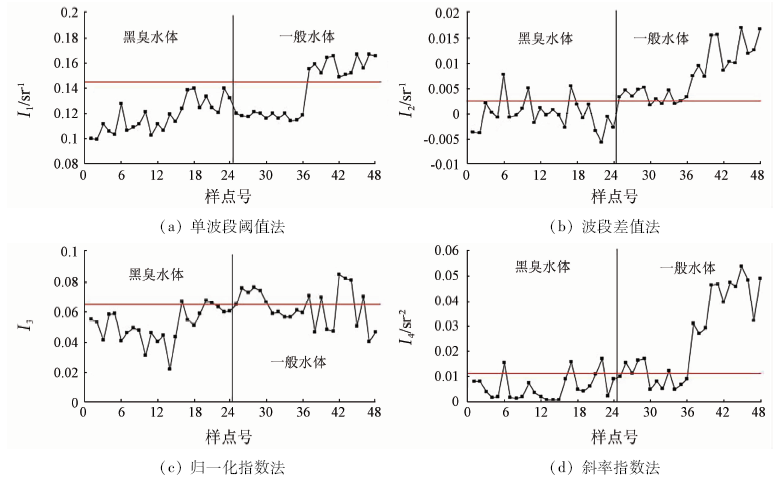
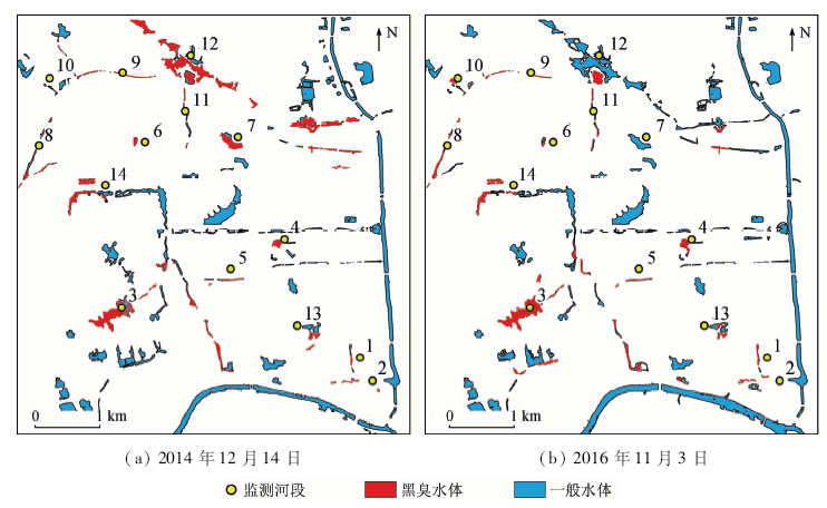
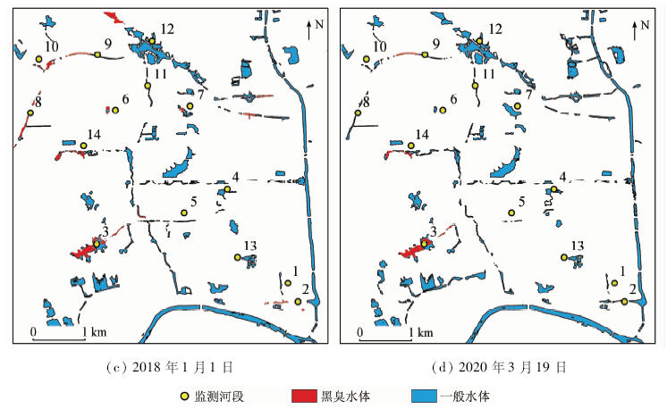
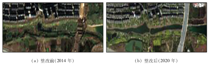
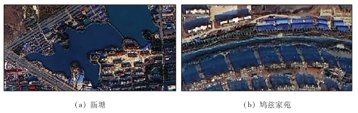
At present, the remote sensing identification of urban black-odor water bodies is in the preliminary stage of algorithm; due to the influence of water depth, shadow and other factors, the accuracy is low in practical applications, and there is little research on the long-term dynamic monitoring of black-odor water bodies. In this study, the Jiujiang District of Wuhu was chosen as a research area to analyze the causes and apparent characteristics of black-odor water bodies. For single-band threshold method, band difference method, normalized index method and slope index method, threshold correction was performed based on GF-2 images, the accuracy was evaluated, combined with the visual interpretation of the black-odor water bodies for dynamic monitoring at the same time. The results are as follows: ① The occurrence of black and odor in the water body is usually accompanied by features such as color abnormality, river siltation, and secondary environmental problems. ②The band difference method has the best recognition effect in the single recognition algorithm, and the total accuracy is 87.5%. ③ The high spatial resolution feature of GF-2 improves the efficiency and accuracy of visual interpretation, which can effectively reduce the interference of water depth and building shadows on its remote sensing recognition; compared with the use of a single algorithm, it further improves the recognition accuracy and reliability of dynamic monitoring. ④ The four GF-2 images from 2014 to 2020 were used to extract the areas of black-odor water bodies in the main urban area of Jiujiang District, which are 0.313 km2, 0.152 km2, 0.069 km2, and 0.008 km2 respectively. The results show that the black and odor phenomenon in the water body of Jiujiang District has been gradually improved, but the black and odor phenomenon in the water system of Shenshan Park is still serious.
胡国庆, 陈冬花, 刘聪芳, 谢以梅, 刘赛赛, 李虎. 基于高分二号的城市黑臭水体动态监测[J]. 国土资源遥感, 2021, 33(1): 30-37.
HU Guoqing, CHEN Donghua, LIU Congfang, XIE Yimei, LIU Saisai, LI Hu. Dynamic monitoring of urban black-odor water bodies based on GF-2 image. Remote Sensing for Land & Resources, 2021, 33(1): 30-37.
The State Council. Action plan for water pollution control[EB/OL].(2015-04-16)[2020-06-06]. http://www.gov.cn/zhengce/content/2015-04/16/content_9613.htm.
Zhao S H, Wang Q, You D A, et al. Application of high resolution satellites to environmental protection[J]. Remote Sensing for Land and Resources, 2015,27(4):1-7.doi: 10.6046/gtzyyg.2015.04.01.
[3]
Nichol J E. Remote sensing of tropical blackwater rivers:A method for environmental water qualityanalysis[J]. Applied Geography, 1993,13(2):153-168.
[4]
Zhao J, Hu C, Lapointe B, et al. Satellite-observed black water events off southwest Florida:Implications for coral reef health in the Florida keys national marine sanctuary[J]. Remote Sensing, 2013,5(1):415-431.
Jin H X, Pan J. Urabn black-odor water body remote sensing monitoring based on GF-2 satellite data fusion[J]. Scientific and Technological Management of Land and Resources, 2017,34(4):107-117.
Wen S. Remote sensing recognition of urban black and odorous water bodies based on GF-2 images:A case study in Nanjing[D]. Nanjing:Nanjing Normal University, 2018.
Wen S, Wang Q, Li Y M, et al. Remote sensing identification of urban black-odor water bodies based on high-resolution images:A case study in Nanjing[J]. Environmental Science, 2018,39(1):57-67.
[8]
姚月. 基于GF多光谱影像的城市黑臭水体识别模型研究[D]. 兰州:兰州交通大学, 2018.
Yao Y. Study on urban black-odor water identification model based on Gaofen multispectral images[D]. Lanzhou:Lanzhou Jiaotong University, 2018.
Yao Y, Shen Q, Zhu L, et al. Remote sensing identification of urban black-odor water bodies in Shenyang City based on GF-2 image[J]. Journal of Remote Sensing, 2019,23(2):230-242.
Qi K K, Shen Q, Luo X J, et al. Remote sensing classification and recognition of black and odorous water in Shenyang based on GF-2 image[J]. Remote Sensing Technology and Application, 2020,35(2):424-434.
[11]
七珂珂. 基于多源高分影像的城市黑臭水体遥感分级识别[D]. 成都:西南交通大学, 2019.
Qi K K. Remote sensing classification and recognition of urban black and odorous water based on multi-source high resolution image[D]. Chengdu:Southwest Jiaotong University, 2019.
Office of the Ministry of Housing and Urban-Rural Development. Investigation of black and odorous waterbodies in cities nationwide[EB/OL].(2016-02-05)[2020-06-06]. http://www.mohurd.gov.cn/wjfb/201602/t20160219_226677.html.
Anhui Provincial People’s Government. Anhui Province water pollution prevention work plan[EB/OL].(2016-01-15)[2020-06-06]. http://www.ah.gov.cn/public/1681/7929561.html.
Li J Q, Dai H Y, Li J G, et al. Remote sensing identification of heavily polluted water in urban areas[J]. Bulletin of Surveying and Mapping, 2018(5):54-58.
 2021, Vol. 33
  ), 陈冬花1,2, 刘聪芳3, 谢以梅1, 刘赛赛2, 李虎1(