Research on application of unmanned aerial vehicle technology to dynamic monitoring of reserves in the Shouyun iron mine, Beijing
Jie XIANG1,2, Jianping CHEN2(), Shi LI2, Zili LAI2, Haozhong HUANG2, Jing LIU2, Shuai XIE2
1. MNR Key Laboratory of Metallogeny and Mineral Assessment, Institute of Mineral Resources, CAGS, Beijing 100037, China 2. School of Earth Sciences and Resources, China University of Geosciences(Beijing), Beijing 100083, China;
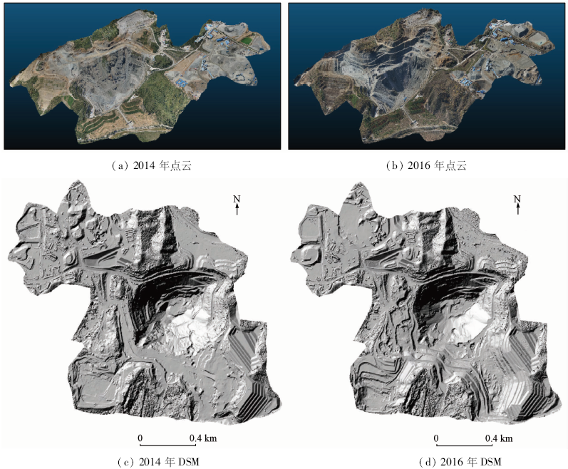
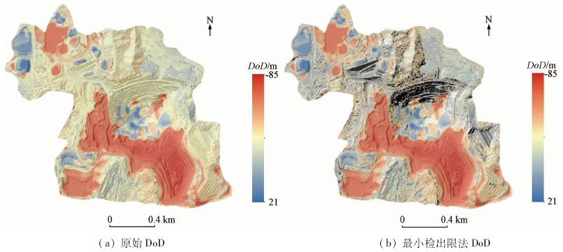
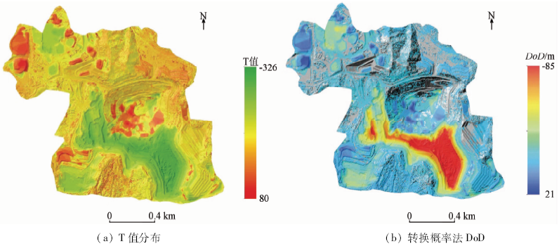
An open challenge for the remote sensing community is to explore a fast, accurate and low-cost method to monitor the open-pit mining. For this purpose, the authors selected the Shouyun iron mine as the case study. Firstly, the authors implemented field campaigns and data acquisition of unmanned aerial vehicle(UAV) in August 2014 and October 2016. Secondly, the authors generated high-resolution of the digital surface model (DSM) and digital orthophoto map (DOM) by using UAV structure from motion (SfM) technology. Finally, the volumetric changes of reserves were calculated by using the algorithm of DSM of difference (DoD), and then multiplied by the average of ore-bearing rate, density of iron ore and ore grade to obtain the mined tonnage. The result shows that the UAV and SfM technology could be a fast and accurate solution for monitoring the reserves of open-pit mines. This study provides a new idea for dynamic monitoring of reserves and environment in open-pit mine.
向杰, 陈建平, 李诗, 赖自力, 黄浩中, 刘静, 谢帅. 无人机遥感技术在北京首云铁矿储量动态监测中的应用[J]. 国土资源遥感, 2018, 30(3): 224-229.
Jie XIANG, Jianping CHEN, Shi LI, Zili LAI, Haozhong HUANG, Jing LIU, Shuai XIE. Research on application of unmanned aerial vehicle technology to dynamic monitoring of reserves in the Shouyun iron mine, Beijing. Remote Sensing for Land & Resources, 2018, 30(3): 224-229.
Li D R, Li M . Research advance and application prospect of unmanned aerial vehicle remote sensing system[J]. Geomatics and Information Science of Wuhan University, 2014,39(5):505-513,540.
Hu Y, Zhang X C, Ma Z Z , et al. Rural residential area extraction from UAV remote sensing imagery[J]. Remote Sensing for Land and Resources, 2016,28(3):96-101.doi: 10.6046/gtzyyg.2016.03.16.
Tang M, Li Y S, Li X , et al. Local enhancement method and its applications to UAV image matching[J]. Remote Sensing for Land and Resources, 2013,25(4):53-57.doi: 10.6046/gtzyyg.2013.04.09.
Shang H Y, Chen J P, Li C Z , et al. Application of remote sensing in the dynamic inspection of the mining:An example in the rare metal ore concentration area of Xinjiang[J]. Remote Sensing Technology and Application, 2008,23(2):189-194.
Yang Q S, Fan B B, Wei X L , et al. Research on the application of unmanned aerial vehicle technology in Xinjiang mineral monitoring[J].Bulletin of Surveying and Mapping, 2015(5):91-94.
Jin D J, Zhi X D, Wang J C , et al. Comparison of UAV remote sensing imagery processing software for geological disasters monitoring[J]. Remote Sensing for Land and Resources, 2016,28(1):183-189.doi: 10.6046/gtzyyg.2016.01.27.
[7]
Chen J P, Li K, Chang K J , et al. Open-pit mining geomorphic feature characterisation[J]. International Journal of Applied Earth Observation and Geoinformation, 2015,42:76-86.
doi: 10.1016/j.jag.2015.05.001
[8]
Lane S N, Richard K S, Chandler J H . Developments in monitoring and modelling small-scale river bed topography[J]. Earth Surface Processes and Landforms, 1994,19(4):349-368.
doi: 10.1002/esp.3290190406
[9]
Wheaton J M, Brasington J, Darby S E , et al. Accounting for uncertainty in DEMs from repeat topographic surveys:Improved sediment budgets[J]. Earth Surface Processes and Landforms, 2010,35(2):136-156.
doi: 10.1002/esp.1886
[10]
Brasington J, Langham J, Rumsby B . Methodological sensitivity of morphometric estimates of coarse fluvial sediment transport[J]. Geomorphology, 2003,53(3/4):299-316.
doi: 10.1016/S0169-555X(02)00320-3
[11]
Lane S N, Westaway R M, Hicks D M . Estimation of erosion and deposition volumes in a large,gravel-bed, braided river using synoptic remote sensing[J]. Earth Surface Processes and Landforms, 2003,28(3):249-271.
doi: 10.1002/(ISSN)1096-9837
 2018, Vol. 30
  ), 李诗2, 赖自力2, 黄浩中2, 刘静2, 谢帅2