Cloud detection algorithm of remote sensing image based on DenseNet and attention mechanism
LIU Guangjin1,2(), WANG Guanghui1,2(), BI Weihua3, LIU Huijie2, YANG Huachao1
1. School of Environment and Spatial Informatics, China University of Mining and Technology, Xuzhou 221116, China 2. Land Satellite Remote Sensing Application Center, MNR, Beijing 100048, China 3. Wanbei Coal and Electricity Co.Ltd., Suzhou 234002, China
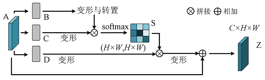
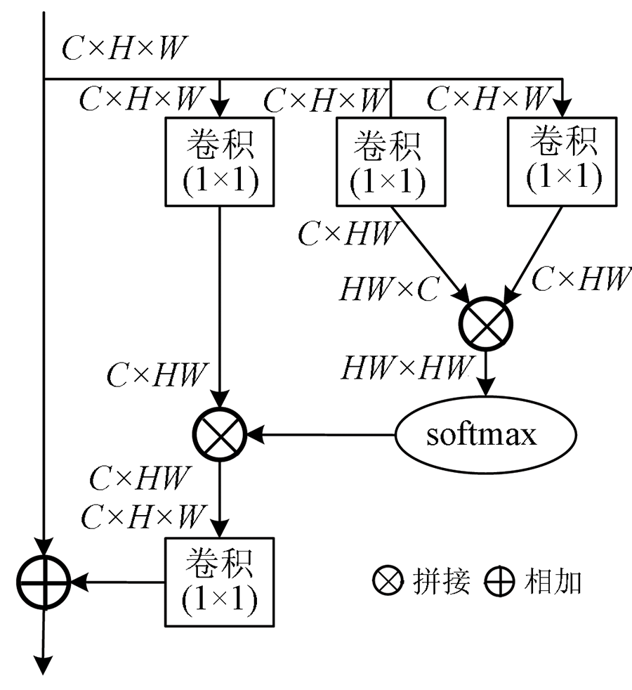
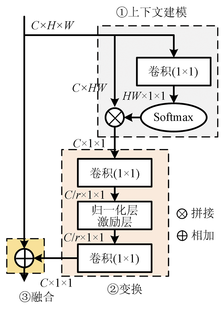
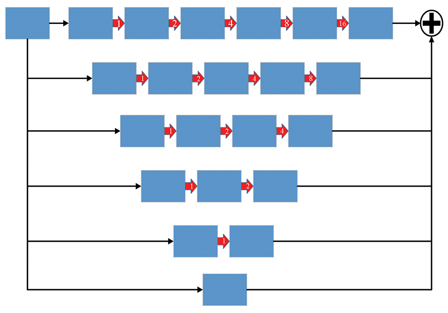
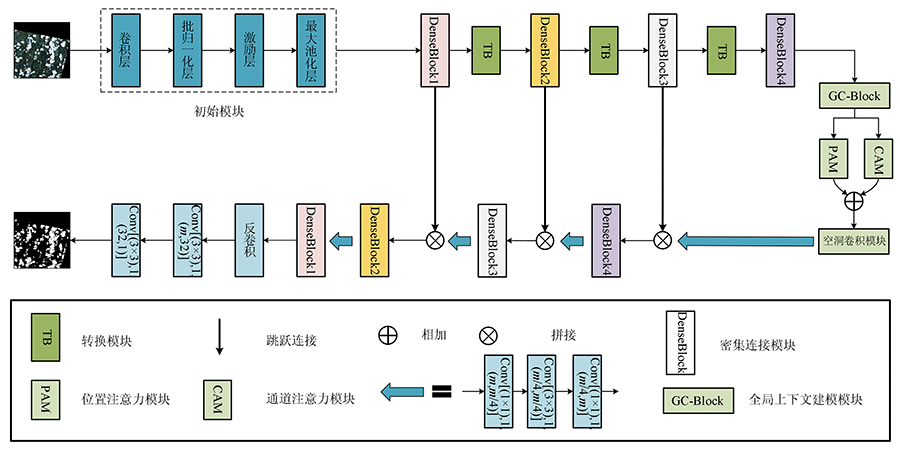
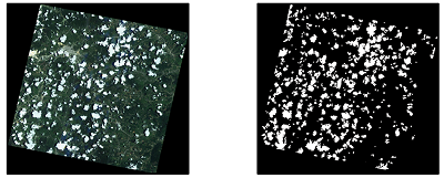
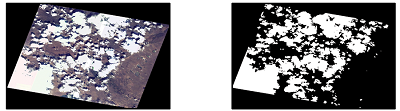
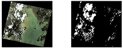
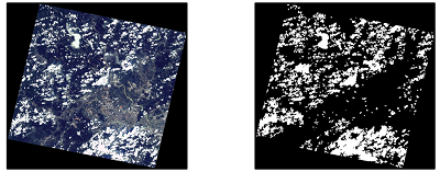
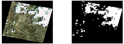
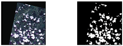
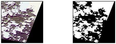
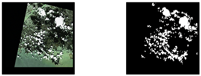
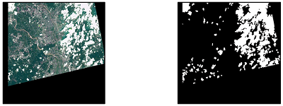
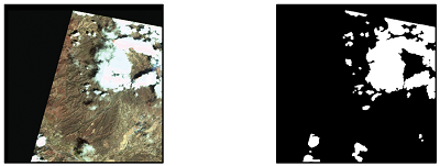
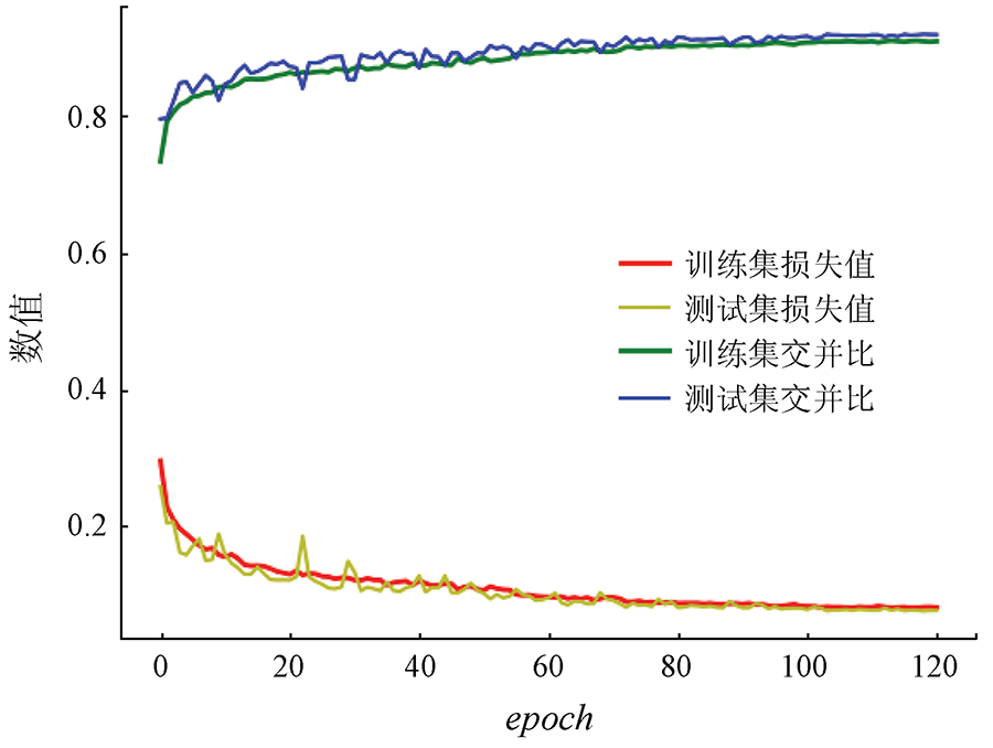
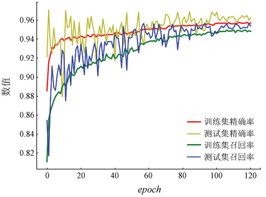
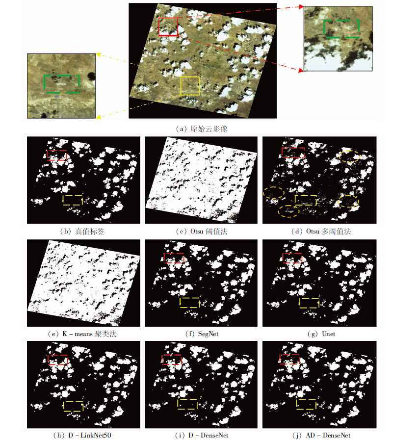
The cloud detection of remote sensing images is the first step in the process of remote sensing image processing. To address the problem that the traditional cloud detection algorithm has a poor effect on the detection of small and thin clouds, this paper proposes a cloud detection method for densely connected network remote sensing images based on the attention mechanism. First, cloud vectors are manually checked from the images provided by the Land Satellite Remote Sensing Application Center of the Ministry of Natural Resources and cloud labels are made, and the images are preprocessed by sequential clipping, color jitter, rotation, etc. to enlarge the sample size. Then, the pre-processed remote sensing images and their labels are fed into a neural network with DenseNet as the encoder and decoder, and a cascaded atrous convolution module is added between the encoder and decoder to increase the receptive field, and a dual attention mechanism and a global context modeling module are added to suppress some irrelevant detailed information. Finally, the experimental results showed that the accuracy rate could reach 95% and the intersection over union could reach 91%, which are big improvements over the traditional cloud detection algorithm, and this method performs well in extracting small and thin clouds.
刘广进, 王光辉, 毕卫华, 刘慧杰, 杨化超. 基于DenseNet与注意力机制的遥感影像云检测算法[J]. 自然资源遥感, 2022, 34(2): 88-96.
LIU Guangjin, WANG Guanghui, BI Weihua, LIU Huijie, YANG Huachao. Cloud detection algorithm of remote sensing image based on DenseNet and attention mechanism. Remote Sensing for Natural Resources, 2022, 34(2): 88-96.
Zhang Y, Rossow W B, Lacis A, et al. Calculation of radiative fluxes from the surface to top of atmosphere based on ISCCP and other global data sets:Refinements of the radiative transfer model and the input data[J]. Journal of Geophysical Research:Atmospheres, 2004, 109(d19):105-115.
[2]
Ju J C, Roy D P. The availability of cloud-free Landsat ETM+ data over the conterminous United States and globally[J]. Remote Sensing of Environment, 2007, 112(3):1196-1211.
doi: 10.1016/j.rse.2007.08.011
[3]
Xie F, Shi M Y, Shi Z, et al. Multilevel cloud detection in remote sensing images based on deep learning[J]. IEEE Journal of Selected Topics in Applied Earth Observations and Remote Sensing, 2017, 10:3631-3640.
doi: 10.1109/JSTARS.2017.2686488
[4]
Zhu Z, Woodcock C E. Object-based cloud and cloud shadow detection in Landsat imagery[J]. Remote Sensing of Environment, 2012, 118:83-94.
doi: 10.1016/j.rse.2011.10.028
[5]
Otsu N. A Threshold selection method from gray-level histograms[J]. IEEE Transactions on Systems Man and Cybernetics, 2007, 9(1):62-66.
doi: 10.1109/TSMC.1979.4310076
Kang Y F, Pan L, Sun M W, et al. Gaussian mixture model based cloud detection for Chinese high resolution satellite imagery[J]. Geomatics and Information Science of Wuhan University, 2017, 42(6):782-788.
Qiu Y F, Chai D F. A deep learning method for Landsat image cloud detection without manually labeled data[J]. Remote Sensing for Land and Resources, 2021, 33(1):102-107.doi: 10.6046/gtzyyg.2020090.
doi: 10.6046/gtzyyg.2020090
Li X S, Liu Y F, Chen D H, et al. Cloud detection based on support vector machine with image features for GF-1 data[J]. Remote Sensing for Land and Resources, 2020, 32(3):55-62.doi: 10.6046/gtzyyg.2020.03.08.
doi: 10.6046/gtzyyg.2020.03.08
Xu Q H, Huang Y B, Chen Y. Cloud detection for Chinese high resolution remote sensing imagery using combining superpixel with convolution neural network[J]. Bulletin of Surveying and Mapping, 2019(1):50-55.
Liu Y F, Yang Z, Han X, et al. Research on cloud detection method of domestic high-resolution satellite images[J]. Bulletin of Surveying and Mapping, 2020(11):66-70.
Zhang J Q, Li X Y, Li L Y, et al. Landsat8 remote sensing image based on deep residual fully convolutional network[J]. Laser and Optoelectronics Progress, 2020, 57(10):364-371.
Zhang Y H, Cai P Y, Tao R Z, et al. Cloud detection for remote sensing images using improved U-Net[J]. Bulletin of Surveying and Mapping, 2020(3):17-20.
Kang C M. Cloud detection in domestic high-resolution remote sensing image based deep neural networks[D]. Xi’an: University of Chinese Academy of Sciences, 2018:20-27.
Zhang C, Zhang X Z, Yang C J. Dual attention RDA-Net for cloud and cloud shadow detection of remote sensing image[J/OL]. Laser and Optoelectronics Progress, 2021:1-19. https://kns.cnki.net/kcms/detail/31.1690.TN.20210222.1114.023.html.
[16]
Zhou L C, Zhang C, Wu M. D-LinkNet:LinkNet with pretrained encoder and dilated convolution for high resolution satellite imagery road extraction[C]// IEEE Conference on Computer Vision and Pattern Recognition (CVPR) Workshops, 2018:182-186.
Peng B. Research on road information extraction of remote sensing image based on deep learning[D]. Chengdu: University of Electronic Science and Technology of China, 2019:45-46.
[18]
Cao Y, Xu J R, Stephen L, et al. GCNet:Non-local networks meet squeeze-excitation networks and beyond[C]// IEEE CVF International Conference on Computer Vision (ICCV), 2019:1971-1980.
[19]
Fu J, Liu J, Tian H, et al. Dual attention network for scene segmentation[C]// IEEE Conference on Computer Vision and Pattern Recognition, 2019:3146-3154.
[20]
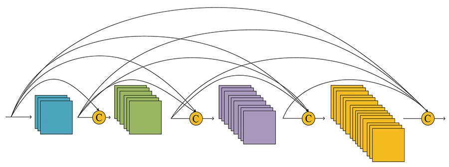
Huang G, Liu Z, Van Der Maaten L, et al. Densely connected convo-lutional networks[C]// Proceedings of the 30th IEEE Conference on Computer Vision and Pattern Recognition(CVPR),Honolulu, 2017.
[21]
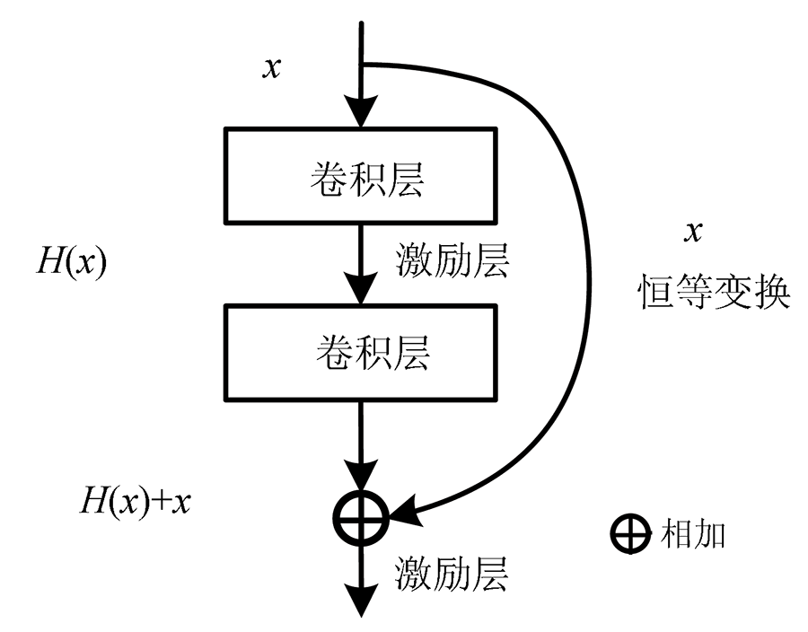
He K M, Zhan X Y, Ren S Q. Deep residual learning for image reco-gnition[C]// IEEE Conference on Computer Vision and Pattern Recognition, 2016:770-778.
[22]
Hu J, Shen L, Sun G. Squeeze-and-excitation networks[C]// IEEE Conference on Computer Vision and Pattern Recognition(CVPR), 2018:7132-7141.
[23]
Woo S, Park J, Lee J Y, et al. CBAM:Convolutional block attention module[C]// 15th European Conference on Computer Vision (ECCV), 2018, 11211:3-19.
[24]
Wang X L, Girshick R, Gupta A, et al. Non-local neural networks[C]// IEEE Conference on Computer Vision and Pattern Recognition, 2018:7794-7803.
[25]
Chen L C, Papandreou G, Kokkinos I, et al. DeepLab:Semantic image segmentation with deep convolutional nets,atrous convolution,and fully connected CRFs[J]. IEEE Transactions on Pattern Analysis and Machine Interlligence, 2018, 40(4):834-848.
 2022, Vol. 34
  ), 王光辉1,2(