A method for constructing a reference dataset for the validation of remote sensing products
CAI Zhenfeng1(), JI Peng2, ZHUFU Xuezhi2, LIU Yufang3()
1. Lanshan Bureau of Natural Resources, Linyi 276001, China 2. Linyi Institute of Natural Resources Surveying and Mapping, Linyi 276000, China 3. Piesat Information Technology Co., Ltd., Beijing 100195, China
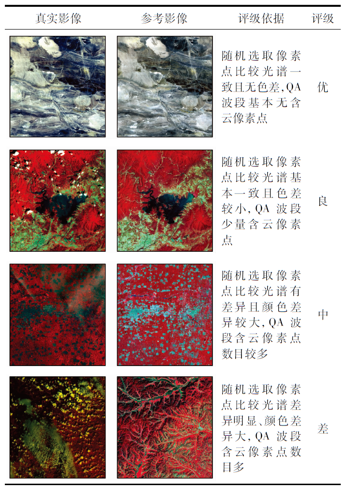
The validation of remote sensing products (RSPs) is necessary for the quality assessment of RSPs in order to ensure the reliable and effective application of RSPs. However, the existing validation of RSPs lacks large-scale engineering reference datasets above the regional level. In view of this fact, this study proposed a cross-validation-based method for constructing a reference dataset for RSP validation. First, a reference dataset of China organized by sheet and time was constructed using the Landsat8 OLI data whose accuracy had been verified. Then, the annual optimal reference dataset, which was easy to retrieve and update and enabled large-scale construction, was formed finally. After seven bands of the ZY1E hyperspectrum were matched according to the center wavelength, the reference dataset was used to verify the reflectance of ZY1E images. The calculation of the confusion matrix between ground truth (GT) data and automatic rating results yielded an overall accuracy of 87% and a Kappa coefficient of 0.83, meeting the requirements for engineering applications. The method for constructing a reference dataset proposed in this study provides technical support for large-scale, engineering-oriented RSP validation.
蔡振锋, 季鹏, 主父学志, 刘玉芳. 面向遥感产品真实性检验的参考数据集构建[J]. 自然资源遥感, 2023, 35(2): 176-181.
CAI Zhenfeng, JI Peng, ZHUFU Xuezhi, LIU Yufang. A method for constructing a reference dataset for the validation of remote sensing products. Remote Sensing for Natural Resources, 2023, 35(2): 176-181.
Wu X D, Xiao Q, Wen J G, et al. Advances in uncertainty analysis for the validation of remote sensing products: Take leaf area index for example[J]. Journal of Remote Sensing, 2014, 18(5):1011-1023.
Wu X D, Wen J G, Xiao Q, et al. Advances in validation methods for remote sensing products of land surface parameters[J]. Journal of Remote Sensing, 2015, 19(1):75-92.
Ma J, Zhou J, Liu S M, et al. Review on validation of remotely sensed land surface temperature[J]. Advances in Earth Science, 2017, 32(6):615-629.
doi: 10.11867/j.issn.1001-8166.2017.06.0615
Jin R, Li X, Ma M G, et al. Key methods and experiment verification for the validation of quantitative remote sensing products[J]. Advances in Earth Science, 2017, 32(6):630-642.
doi: 10.11867/j.issn.1001-8166.2017.06.0630
Gao H L, Gu X F, Zhou X, et al. Framework design of remote sensing common product validation system[J]. Radio Engineering, 2021, 51(12):1389-1396.
[6]
Justice C, Belward A, Morisette J T, et al. Developments in the validation of satellite sensor products for the study of the land surface[J]. International Journal of Remote Sensing, 2000, 21 (17):3383-3390.
doi: 10.1080/014311600750020000
[7]
Baret F, Morissette J, Fernandes R, et al. Evaluation of the representativeness of networks of sites for the global validation and intercomparison of land biophysical products: Proposition of the CEOS-BELMANIP[J]. IEEE Transactions on Geoscience and Remote Sensing, 2006, 44(7):1794-1803.
doi: 10.1109/TGRS.2006.876030
Zhang L. The research of the validation of remote sensing land surface products and system implementation[D]. Chengdu: University of Electronic Science and Technology of China, 2015.
Zhang R H, Tian J, Li Z L, et al. Principles and methods for the validation of quantitative remote sensing products[J]. Science China Earth Sciences, 2010, 40(2):211-222.
Yang Y J, Tian Q J, Huang Y, et al. Validation of rice leaf area index inversion on GF-1 satellite remote sensing imagery[J]. Remote Sensing Information, 2015, 30(5):62-68.
Lin X W. Land surface albedo remote sensing products validation over rugged terrain[D]. Beijing: University of Chinese Academy of Sciences (Institute of Remote Sensing and Digital Earth,Chinese Academy of Sciences), 2018.
[12]
Weiss M, Baret F, Garrigues S, et al. LAI and fAPAR CYCLOPES global products derived from VEGETATION.Part 2: Validation and comparison with MODIS collection 4 products[J]. Remote Sensing of Environment, 2007, 110 (3):317-331.
doi: 10.1016/j.rse.2007.03.001
Yu H, Feng Q S, Chen S Y, et al. Grassland biomass dynamic monitoring in Gannan Prefecture based on the microwave vegetation indices[J]. Journal of Lanzhou University (Natural Sciences), 2011, 47(4):69-74.
[14]
Chen Y M, Liang S, Wang J, et al. Validation of MISR land surface broadband albedo[J]. International Journal of Remote Sensing, 2002, 29 (23):6971-6983.
doi: 10.1080/01431160802199876
 2023, Vol. 35
  ), 季鹏2, 主父学志2, 刘玉芳3(