|
|
|
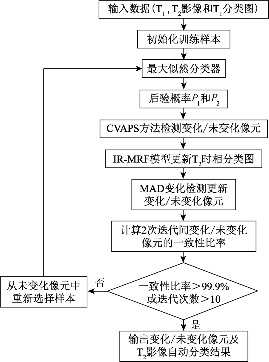
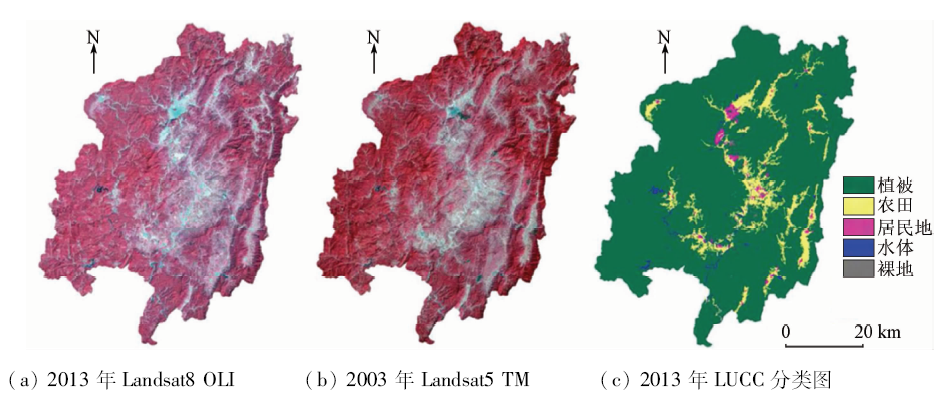
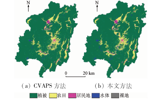
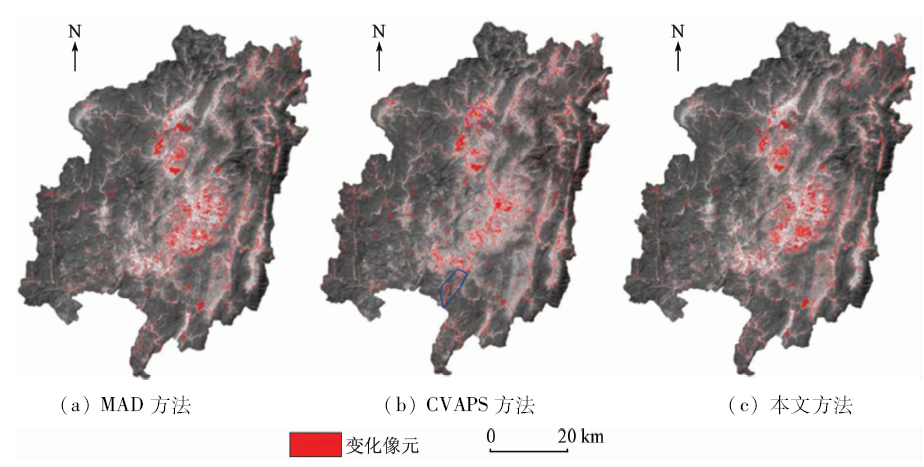
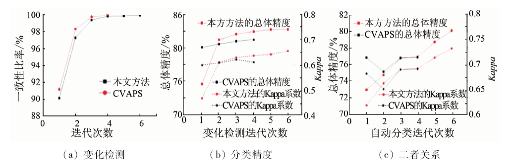
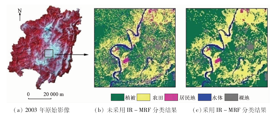
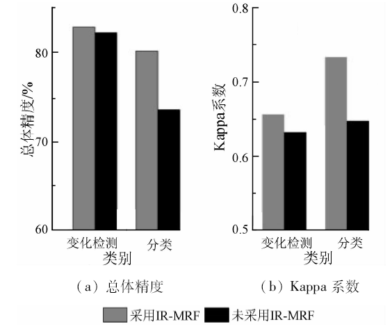
Abstract The method of change vector analysis in posterior probability space(CVAPS) does not take into consideration the correlation between the bands of remote sensing image, which may result in unreliable change detection. In view of such a situation, the authors introduced multivariate change detection(MAD)method and, in combination with CVAPS, proposed an improved method for automatic updating of land use / cover change(LUCC) classification. The method firstly introduces MAD to reduce bands-correlation for improving the reliability of train-samples and accordingly improving LUCC updating maps, and then included an iterative Markov random field(IR-MRF)model to fully employ the contextual information in post-processing to reduce the noise of “salt-and-pepper”. Choosing Changting County of Fujian Province as the study area, the authors used Landsat5 TM and Landsat8 OLI data acquired in 2003 and 2013 respectively, and took OLI as the base image to update the classification map in 2003. The experimental results show that the proposed method significantly outperforms the CVAPS in that its overall accuracy could reach 80% with the improvement rate being about 3%.
|
| Keywords
land use/cover change(LUCC)
automatic updating
multivariate change detection(MAD)
change vector analysis in posterior probability space(CVAPS)
iterative Markov random field(IR-MRF)model
|
|
|
|
Corresponding Authors:
Bo WU
E-mail: 1161336850@qq.com;wavelet778@sohu.com
|
|
Issue Date: 30 May 2018
|
|
|
| [1] |
Turner II B L,Skole D L,Sanderson S,et al. Land-Use and Land-Cover Change Science/Research Plan[R].Stockholm,Geneva:[s.n.], 1995.
|
| [2] |
李秀彬 . 全球环境变化研究的核心领域——土地利用/土地覆被变化的国际研究动向[J]. 地理学报, 1996,51(6):553-558.
|
| [2] |
Li X B . A review of the international researches on land use/land cover change[J]. Acta Geographica Sinica, 1996,51(6):553-558.
|
| [3] |
王秀兰, 包玉海 . 土地利用动态变化研究方法探讨[J]. 地理科学进展, 1999,18(1):81-87.
doi: 10.3969/j.issn.1007-6301.1999.01.012
url: http://d.wanfangdata.com.cn/Periodical/dlkxjz199901012
|
| [3] |
Wang X L, Bao Y H . Study on the methods of land use dynamic change research[J]. Progress in Geography, 1999,18(1):81-87.
|
| [4] |
Turner II B L,Meyer W B,Skole D L. Global land-use/land-cover change:Towards an integrated study[J]. Ambio, 1994,23(1):91-95.
doi: 10.1080/02786829408959678
url: http://www.jstor.org/stable/4314168
|
| [5] |
孙晓霞, 张继贤, 燕琴 , 等. 遥感影像变化检测方法综述及展望[J]. 遥感信息, 2011,26(1):119-123.
doi: 10.3969/j.issn.1000-3177.2011.01.023
url: http://www.cqvip.com/Main/Detail.aspx?id=37250445
|
| [5] |
Sun X X, Zhang J X, Yan Q , et al. A summary on current techniques and prospects of remote sensing change detection[J]. Remote Sensing Information, 2011,26(1):119-123.
|
| [6] |
Chen X H, Chen J, Shi Y S , et al. An automated approach for updating land cover maps based on integrated change detection and classification methods[J]. ISPRS Journal of Photogrammetry and Remote Sensing, 2012,71:86-95.
doi: 10.1016/j.isprsjprs.2012.05.006
url: http://linkinghub.elsevier.com/retrieve/pii/S092427161200086X
|
| [7] |
Xian G, Homer C, Fry J.Updating the 2001 national land cover database land cover classification to 2006 by using Landsat imagery change detection methods[J]. Remote Sensing of Environment, 2009,113(6):1133-1147.
doi: 10.1016/j.rse.2009.02.004
url: http://www.cabdirect.org/abstracts/20093156944.html
|
| [8] |
Xian G, Homer C .Updating the 2001 national land cover database impervious surface products to 2006 using Landsat imagery change detection methods[J]. Remote Sensing of Environment, 2010,114(8):1676-1686.
doi: 10.1016/j.rse.2010.02.018
url: http://linkinghub.elsevier.com/retrieve/pii/S0034425710000878
|
| [9] |
Jin S M, Yang L M, Danielson P , et al.A comprehensive change detection method for updating the national land cover database to circa 2011[J].Remote Sensing of Environment, 2013,132:159-175.
doi: 10.1016/j.rse.2013.01.012
url: http://linkinghub.elsevier.com/retrieve/pii/S0034425713000242
|
| [10] |
Chen J, Chen X H, Cui X H , et al. Change vector analysis in posterior probability space:A new method for land cover change detection[J]. IEEE Geoscience and Remote Sensing Letters, 2011,8(2):317-321.
doi: 10.1109/LGRS.2010.2068537
url: http://ieeexplore.ieee.org/document/5597922/
|
| [11] |
张路 . 基于多元统计分析的遥感影像变化检测方法研究[D]. 武汉:武汉大学, 2004.
|
| [11] |
Zhang L . Change Detection in Remotely Sensed Imagery Using Multivariate Statistical Analysis[D]. Wuhan: Wuhan University, 2004.
|
| [12] |
盛辉, 廖明生, 张路 . 基于典型相关分析的变化检测中变化阈值的确定[J]. 遥感学报, 2004,8(5):451-457.
doi: 10.3321/j.issn:1007-4619.2004.05.011
url: http://www.cqvip.com/qk/92457A/200405/10332896.html
|
| [12] |
Sheng H, Liao M S, Zhang L . Determination of threshold in change detection based on canonical correlation analysis[J]. Journal of Remote Sensing, 2004,8(5):451-457.
|
| [13] |
廖明生, 朱攀, 龚健雅 . 基于典型相关分析的多元变化检测[J]. 遥感学报, 2000,4(3):197-201,246.
doi: 10.11834/jrs.20000307
|
| [13] |
Liao M S, Zhu P, Gong J Y . Multivariate change detection based on canonical transformation[J]. Journal of Remote Sensing, 2000,4(3):197-201,246.
|
| [14] |
Nielsen A A, Conradsen K, Simpson J J . Multivariate alteration detection(MAD) and MAF postprocessing in multispectral,bitemporal image data:New approaches to change detection studies[J]. Remote Sensing of Environment, 1998,64(1):1-19.
doi: 10.1016/S0034-4257(97)00162-4
url: http://linkinghub.elsevier.com/retrieve/pii/S0034425797001624
|
| [15] |
Nielsen A A . The regularized iteratively reweighted MAD method for change detection in multi-and hyperspectral data[J]. IEEE Transactions on Image Processing, 2007,16(2):463-478.
doi: 10.1109/TIP.2006.888195
pmid: 17269639
url: http://ieeexplore.ieee.org/document/4060945/
|
| [16] |
Kapur J N, Sahoo P K, Wong A K C.A new method for gray-level picture thresholding using the entropy of the histogram[J]. Computer Vision,Graphics,and Image Processing, 1985,29(3):273-285.
doi: 10.1016/0734-189X(85)90125-2
url: http://linkinghub.elsevier.com/retrieve/pii/0734189X85901252
|
| [17] |
Bruzzone L, Prieto D F . Automatic analysis of the difference image for unsupervised change detection[J]. IEEE Transactions on Geoscience and Remote Sensing, 2000,38(3):1171-1182.
doi: 10.1109/36.843009
url: http://ieeexplore.ieee.org/document/843009/
|
| [18] |
赵鹏 . 新街台格庙矿区开发初期土地利用动态遥感监测[J]. 国土资源遥感, 2015,27(4):144-149.doi: 10.6046/gtzyyg.2015.04.22.
doi: 10.6046/gtzyyg.2015.04.22
|
| [18] |
Zhao P . Land use dynamic remote sensing monitoring at the initial stage of exploitation of the Xinjie Taigemiao mining area[J]. Remote Sensing for Land and Resources, 2015,27(4):144-149.doi: 10.6046/gtzyyg.2015.04.22.
|
| [19] |
国巧真, 宁晓平, 王志恒 , 等. 地形地貌对半山区土地利用动态变化影响分析——以天津市蓟县为例[J]. 国土资源遥感, 2015,27(1):153-159.doi: 10.6046/gtzyyg.2015.01.24.
doi: 10.6046/gtzyyg.2015.01.24
url: http://www.cqvip.com/QK/91397X/201501/663991084.html
|
| [19] |
Guo Q Z, Ning X P, Wang Z H , et al. Impact analysis of landform for land use dynamic change of the partly mountainous area:A case study of Jixian County in Tianjin City[J]. Remote Sensing for Land and Resources, 2015,27(1):153-159.doi: 10.6046/gtzyyg.2015.01.24.
|
| [20] |
李莎, 倪维平, 严卫东 , 等. 基于选权迭代估计与非监督分类的多光谱图像变化检测[J]. 国土资源遥感, 2014,26(4):34-40.doi: 10.6046/gtzyyg.2014.04.06.
doi: 10.6046/gtzyyg.2014.04.06
url: http://www.cqvip.com/QK/91397X/201404/663060360.html
|
| [20] |
Li S, Ni W P, Yan W D , et al. Change detection of multi-spectral images based on iterative estimation with weight selection and unsupervised classification[J]. Remote Sensing for Land and Resources, 2014,26(4):34-40.doi: 10.6046/gtzyyg.2014.04.06.
|
| [21] |
杜培军, 陈宇, 谭琨 . 江苏滨海湿地土地利用/覆盖变化与地表温度响应遥感监测[J]. 国土资源遥感, 2014,26(2):112-120.doi: 10.6046/gtzyyg.2014.02.19.
doi: 10.6046/gtzyyg.2014.02.19
|
| [21] |
Du P J, Chen Y, Tan K . The remote sensing monitoring of land use/cover change and land surface temperature responses over the coastal wetland in Jiangsu[J]. Remote Sensing for Land and Resources, 2014,26(2):112-120.doi: 10.6046/gtzyyg.2014.02.19.
|
| [22] |
孙雷刚, 刘剑锋, 徐全洪 . 河北坝上地区植被覆盖变化遥感时空分析[J]. 国土资源遥感, 2014,26(1):167-172.doi: 10.6046/gtzyyg.2014.01.28.
doi: 10.6046/gtzyyg.2014.01.28
url: http://d.wanfangdata.com.cn/Periodical/gtzyyg201401028
|
| [22] |
Sun L G, Liu J F, Xu Q H . Remote Sensing based temporal and spatial analysis of vegetation cover changes in Bashang Area of Hebei Province[J]. Remote Sensing for Land and Resources, 2014,26(1):167-172.doi: 10.6046/gtzyyg.2014.01.28.
|
|
Viewed |
|
|
|
Full text
|
|
|
|
|
Abstract
|
|
|
|
|
Cited |
|
|
|
|
| |
Shared |
|
|
|
|
| |
Discussed |
|
|
|
|
 2018,
Vol. 30
2018,
Vol. 30
 ), Bo WU(