|
|
 |
|

|
|
|
A machine learning algorithm for automatic identification of cultivated land in remote sensing images |
Xun ZHOU1,2, Yuebin WANG3, Suhong LIU1,2( ), Peixin YU1,2, Xikai WANG1,2 ), Peixin YU1,2, Xikai WANG1,2 |
1. School of Geography, Beijing Normal University, Beijing 100875, China
2. Faculty of Geographical Science, Beijing Normal University, Beijing 100875, China
3. School of Mathematical Sciences, Beijing Normal University, Beijing 100875, China |
|
|
|
|
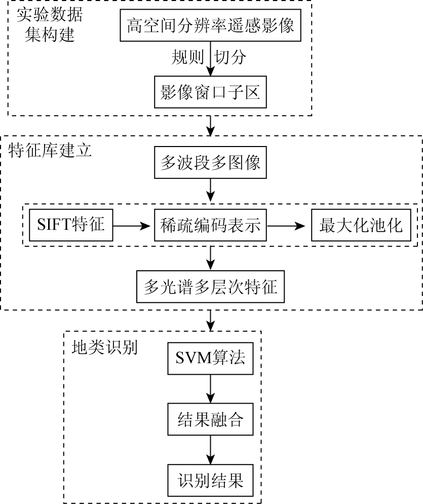
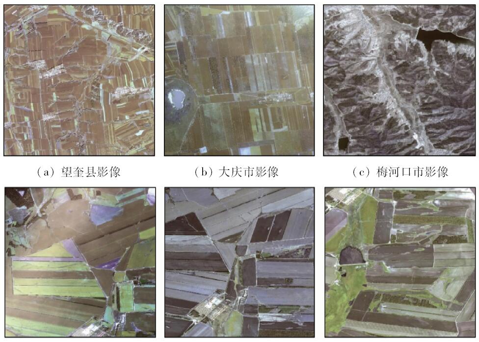
Abstract As an important kind of land resources, cultivated land is related to the country’s food security. So it is very significant to have a fast and accurate method for obtaining information of cultivated land. The traditional supervised classification methods of remote sensing image are based on the consistency of the spectral features or texture features between the training samples and the pixels/patches to be classified. These methods have strong dependence on training samples. This paper proposes an automatic classification algorithm of cultivated land based on the image window subarea. By using the machine learning algorithm, the automatic classification of cultivated land or non-cultivated land in the sub region of the image window can be realized by extracting the multi-spectral and multi-level features. Using this method, the unsupervised automatic classification of the type of the image window subarea is realized by establishing the feature database of the remote sensing image of the cultivated land in a certain area. With the high spatial resolution remote sensing image of Northeast China as an example, the experimental results show that the accuracy of the automatic classification algorithm is 90.8%. Being able to automatically acquire the cultivated land information, this method can also be used to extract any pure ground object from remote sensing images.
|
| Keywords
image window subarea
feature database
machine learning
automatic identification of cultivated land
|
|
|
|
Corresponding Authors:
Suhong LIU
E-mail: liush@bnu.edu.cn
|
|
Issue Date: 07 December 2018
|
|
|
| [1] |
曹鑫, 陈学泓, 张委伟 , 等. 全球30 m空间分辨率耕地遥感制图研究[J]. 中国科学(地球科学), 2016,46(11):1426-1435.
|
| [1] |
Cao X, Chen X H, Zhang W W , et al. Research on global 30 m spatial resolution remote sensing mapping of cultivated land[J]. Scientia Sinica(Terrae), 2016,46(11):1426-1435.
|
| [2] |
满卫东, 王宗明, 刘明月 , 等. 1990—2013年东北地区耕地时空变化遥感分析[J]. 农业工程学报, 2016,34(7):1-10.
doi: 10.11975/j.issn.1002-6819.2016.07.001
url: http://d.wanfangdata.com.cn/Periodical/nygcxb201607001
|
| [2] |
Man W D, Wang Z M, Liu M Y , et al. Spatio-temporal dynamics analysis of cropland in Northeast China during 1990—2013 based on remote sensing[J]. Transactions of the Chinese Society of Agricultural Engineering, 2016,34(7):1-10.
|
| [3] |
Shackelford A K, Davis C H . A combined fuzzy pixel-based and object-based approach for classification of high-resolution multispectral data over urban areas[J]. IEEE Transactions on Geoscience and Remote Sensing, 2003,41(10):2354-2363.
doi: 10.1109/TGRS.2003.815972
url: http://ieeexplore.ieee.org/document/1237403/
|
| [4] |
靳欢欢 . 基于逐像元和面向对象分类方法的分析研究[J].江苏科技信息, 2014(19):38-40.
|
| [4] |
Jin H H . Analysis and research on the the pixel-based and object oriented classification[J].Jiangsu Science and Technology Information,2014(19):38-40.
|
| [5] |
蔡银桥, 毛政元 . 基于多特征对象的高分辨率遥感影像分类方法及其应用[J]. 国土资源遥感, 2007,19(1):77-81.doi: 10.6046/gtzyyg.2007.01.17.
|
| [5] |
Cai Y Q, Mao Z Y . A method for classification of high resolution remotely sensed images based on multi-feature objects and its application[J]. Remote Sensing for Land and Resources, 2007,19(1):77-81.doi: 10.6046/gtzyyg.2007.01.17.
|
| [6] |
朱述龙, 张占睦 . 遥感图像获取与分析[M]. 北京: 科学出版社, 2000.
|
| [6] |
Zhu S L, Zhang Z M. Remote Sensing Image Acquisition and Analysis[M]. Beijing: Science Press, 2000.
|
| [7] |
别强, 何磊, 赵传燕 . 基于影像融合和面向对象技术的植被信息提取研究[J]. 遥感技术与应用, 2014,29(1):164-171.
doi: 10.11873/j.issn.1004-0323.2014.1.0164
url: http://www.cqvip.com/QK/96858A/201401/48992873.html
|
| [7] |
Bie Q, He L, Zhao C Y . Study on vegetation information extraction based on object-oriented image analysis[J]. Remote Sensing Technology and Application, 2014,29(J):164-171.
|
| [8] |
徐世武, 杨双, 孙飞 , 等. 面向对象的高分辨率影像单值分类耕地提取方法研究[J].测绘通报, 2014(10):78-81.
|
| [8] |
Xu S W, Yang S, Sun F , et al. Method research on cultivated land extraction based on object one-class classification of high-spatial-resolution images[J].Bulletin of Surveying and Mapping,2014(10):78-81.
|
| [9] |
Hay G J, Marceau D J, Dubé P , et al. A multiscale framework for landscape analysis:Object-specific analysis and upscaling[J]. Landscape Ecology, 2001,16(6):471-490.
doi: 10.1023/A:1013101931793
url: http://link.springer.com/10.1023/A:1013101931793
|
| [10] |
周春艳 . 面向对象的高分辨率遥感影像信息提取技术[D]. 青岛:山东科技大学, 2006.
|
| [10] |
Zhou C Y . Object-oriented Information Extraction Technology of High Resolution Remote Sensing Image[D]. Qingdao:Shandong University of Science and Technology, 2006.
|
| [11] |
刘志刚, 史文中, 李德仁 , 等. 一种基于支撑向量机的遥感影像不完全监督分类新方法[J]. 遥感学报, 2005,9(4):363-373.
|
| [11] |
Liu Z G, Shi W Z, Li D R , et al. Partially supervised classification of remotely sensed imagery using support vector machines[J]. Journal of Remote Sensing, 2005,9(4):363-373.
|
| [12] |
吕书强, 田巨慧, 杜磊 , 等. 加权纹理特征在高分辨率遥感影像耕地再分类中的应用[J]. 测绘科学, 2009,34(s1):67-69.
|
| [12] |
Lyu S Q, Tian J H, Du L , et al. Sub-classification of farmland with weighted textural features in high resolution remote sensing images[J]. Science of Surveying and Mapping, 2009,34(s1):67-69.
|
| [13] |
Thouret J, Kassouk Z, Gupta A , et al. Tracing the evolution of 2010 Merapi volcanic deposits (Indonesia) based on object-oriented classification and analysis of multi-temporal,very high resolution images[J]. Remote Sensing of Environment, 2015,170(47):350-371.
doi: 10.1016/j.rse.2015.09.028
url: https://linkinghub.elsevier.com/retrieve/pii/S0034425715301516
|
| [14] |
胡婷 . 遥感图像典型地物特征提取的尺度效应研究[D]. 西安:西北大学, 2010.
|
| [14] |
Hu T . The Study of Scale Effects in Typical Objects’ Feature Extraction from Remote Sensing Image[D]. Xi’an:Northwest University, 2010.
|
| [15] |
朱秀芳, 潘耀忠, 张锦水 , 等. 训练样本对TM尺度小麦种植面积测量精度影响研究(Ⅰ)——训练样本与分类方法间分类精度响应关系研究[J]. 遥感学报, 2007,11(6):826-837.
|
| [15] |
Zhu X F, Pan Y Z, Zhang J S , et al. The effects of training samples on the wheat planting area measure accuracy in TM scale(Ⅰ):The accuracy response of different classifiers to training samples[J]. Journal of Remote Sensing, 2007,11(6):826-837.
|
| [16] |
武鹏飞 . 延怀盆地景观格局动态过程研究[D]. 北京:首都师范大学, 2013.
|
| [16] |
Wu P F . Research on the Dynamic Process of Landscape Pattern in Yan Huai Basin[D]. Beijing:Capital Normal University, 2013.
|
| [17] |
程起敏 . 基于内容的遥感影像库检索关键技术研究[D].北京:中国科学院研究生院( 遥感应用研究所), 2004.
|
| [17] |
Cheng Q M . Reaserch on Key Technologies for Content-based Retrieval from Remote Sensing Image Database[D].Beijing:Graduate University of Chinese Academy of Sciences ( Institute of Remote Sensing Applications), 2004.
|
| [18] |
王跃宾 . 面向机器学习的高分辨率光学遥感影像识别方法[D]. 北京:北京师范大学, 2016.
|
| [18] |
Wang Y B . High Spatial Rseolution Remote Sensing Images Recognition by Means of Machine Learning[D]. Beijing:Beijing Normal University, 2016.
|
| [19] |
Lowe D G . Distinctive image features from scale-invariant keypoints[J]. International Journal of Computer Vision, 2004,60(2):91-110.
doi: 10.1023/B:VISI.0000029664.99615.94
url: http://link.springer.com/10.1023/B:VISI.0000029664.99615.94
|
| [20] |
Yang J C, Yu K, Gong Y H, et al. Linear spatial pyramid matching using sparse coding for image classification [C]//IEEE Conference on Computer Vision and Pattern Recognition.Miami:Cvpr, 2009: 1794-1801.
|
| [21] |
Bazi Y, Melgani F . Toward an optimal SVM classification system for hyperspectral remote sensing images[J]. IEEE Transactions on Geoscience and Remote Sensing, 2006,44(11):3374-3385.
doi: 10.1109/TGRS.2006.880628
url: http://ieeexplore.ieee.org/document/1717732/
|
|
Viewed |
|
|
|
Full text
|
|
|
|
|
Abstract
|
|
|
|
|
Cited |
|
|
|
|
| |
Shared |
|
|
|
|
| |
Discussed |
|
|
|
|
 2018,
Vol. 30
2018,
Vol. 30