|
|
 |
|

|
|
|
Mapping the key ecological service regions of mountains based on remote sensing and GIS |
Yao LI1, Chengming YE2( ), Qiang XIE3, Li LIANG1 ), Qiang XIE3, Li LIANG1 |
1. Key Laboratory of Mountain Hazards and Earth Surface Processes, Institute of Mountain Hazards and Environment, Chinese Academy of Sciences, Chengdu 610041, China
2. Key Laboratory of Earth Exploration and Information Technology of Ministry of Education, Chengdu University of Technology, Chengdu 610059, China
3. Sichuan Provincial Research Academy of Environmental Protection Sciences, Chengdu 610041, China |
|
|
|
|
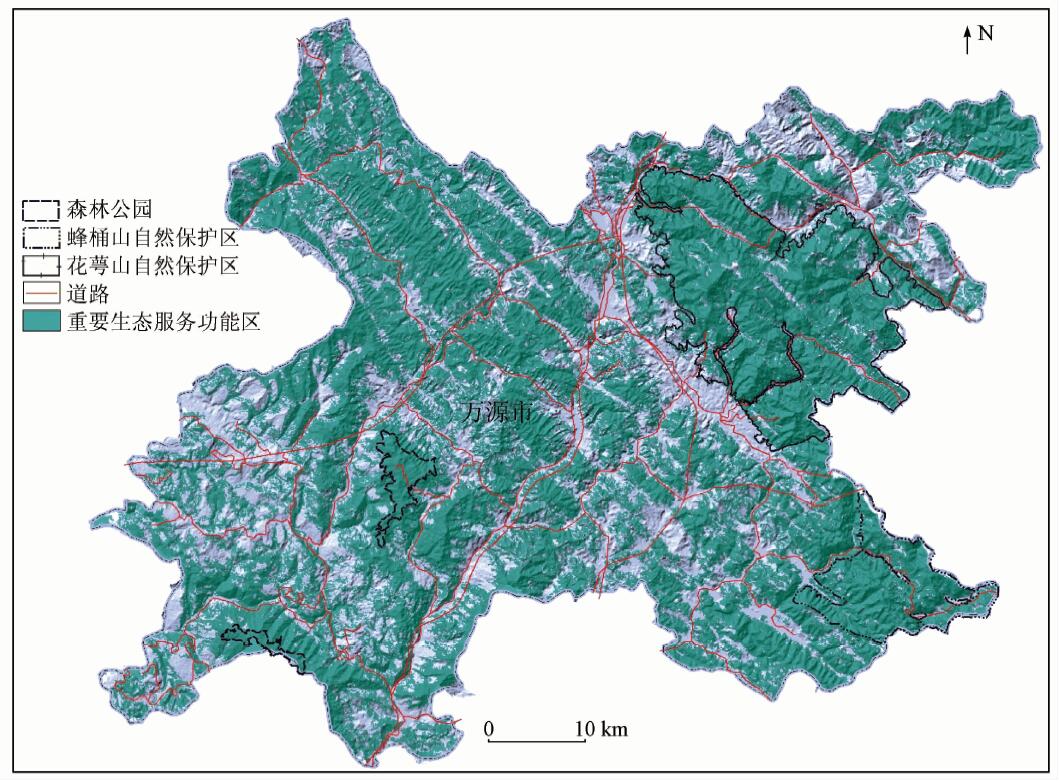
Abstract Mapping and protecting the key ecological service regions has been considered as the basis of the development of the society and economy. With the development of remote sensing (RS) and geographic information system (GIS) technology, this technique has been applied to monitoring the ecological environment and evaluating the ecological services. This paper proposes an approach to calculating the efficiency index of protection and mapping the key ecological service regions in the situation where the index is maximal. As a application, Wanyuan, the typical mountain region, was examined. The results show that the key ecological service regions cover a total area of 2 651.99 km 2, accounting for 65.4% of the study area. And it could be concluded that the key ecological service regions are distributed from steep slopes [15°,35°) where the elevation is more than 800 meters. The results suggest management to increase the efforts on protection. This paper can provide technical support for mapping the key ecological service regions of mountains.
|
| Keywords
mountain region
RS and GIS
efficiency index of protection
key ecological service regions
|
|
|
|
Corresponding Authors:
Chengming YE
E-mail: rsgis@sina.com
|
|
Issue Date: 07 December 2018
|
|
|
| [1] |
Wilson C M, Matthews W H . Man’s Impact on the Global Environment[R].Report of the Study of Critical Environmental Problems(SCEP). 1970.
|
| [2] |
Costanza R, d’Arge R, Groot R D , et al. The value of the world’s ecosystem services and natural capital[J]. Ecological Economics, 1998,25(1):3-15.
doi: 10.1038/387253a0
url: http://linkinghub.elsevier.com/retrieve/pii/S0921800998000202
|
| [3] |
欧阳志云, 王如松, 赵景柱 . 生态系统服务功能及其生态经济价值评价[J]. 应用生态学报, 1999,10(5):635-640.
doi: 10.1088/0256-307X/15/12/025
url: http://d.wanfangdata.com.cn/Periodical/yystxb199905034
|
| [3] |
Ouyang Z Y, Wang R S, Zhao J Z . Ecosystem services and their economic valuation[J]. Chinese Journal of Applied Ecology, 1999,10(5):635-640.
|
| [4] |
董全 . 生态功益:自然生态过程对人类的贡献[J]. 应用生态学报, 1999,10(2):106-113.
url: http://www.cqvip.com/Main/Detail.aspx?id=3550854
|
| [4] |
Dong Q . Ecosystem services:The biological conditions and ecological supports necessary for the development of human societies[J]. Chinese Journal of Applied Ecology, 1999,10(2):106-113.
|
| [5] |
郭中伟, 李典谟, 甘雅玲 . 森林生态系统生物多样性的遥感评估[J]. 生态学报, 2001,21(8):1369-1384.
doi: 10.3321/j.issn:1000-0933.2001.08.023
url: http://d.wanfangdata.com.cn/Periodical/stxb200108023
|
| [5] |
Guo Z W, Li D M, Gan Y L . The assessment of forest ecosystem biodiversity by remote sensing[J]. Acta Ecological Sinica, 2011,21(8):1369-1384.
|
| [6] |
Petrou Z I, Manakos I, Stathaki T . Remote sensing for biodiversity monitoring:A review of methods for biodiversity indicator extraction and assessment of progress towards international targets[J]. Biodiversity and Conservation, 2015,24(10):2333-2363.
doi: 10.1007/s10531-015-0947-z
url: http://link.springer.com/10.1007/s10531-015-0947-z
|
| [7] |
Coops N C, Fontana F M A, Harvey G K A, et al. Monitoring of a national-scale indirect indicator of biodiversity using a long time-series of remotely sensed imagery[J]. Canadian Journal of Remote Sensing, 2014,40(3):179-191.
doi: 10.1080/07038992.2014.945826
url: http://www.tandfonline.com/doi/full/10.1080/07038992.2014.945826
|
| [8] |
李文华, 张彪, 谢高地 . 中国生态系统服务研究的回顾与展望[J]. 自然资源学报, 2009,24(1):1-10.
doi: 10.11849/zrzyxb.2009.01.001
url: http://d.wanfangdata.com.cn/Periodical_zrzyxb200901001.aspx
|
| [8] |
Li W H, Zhang B, Xie G D . Research on ecosystem services in China:Progress and perspectives[J]. Journal of Naturel Resources, 2009,24(1):1-10.
|
| [9] |
Alexakis D D, Hadjimitsis D G, Agapiou A . Integrated use of remote sensing,GIS and precipitation data for the assessment of soil erosion rate in the catchment area of“Yialias” in Cyprus[J]. Atmospheric Research, 2013,131(2):108-124.
doi: 10.1016/j.atmosres.2013.02.013
url: https://linkinghub.elsevier.com/retrieve/pii/S0169809513000744
|
| [10] |
Eckert S, Ghebremicael S T, Hurni H , et al. Identification and classification of structural soil conservation measures based on very high resolution stereo satellite data[J]. Journal of Environmental Management, 2017,193:592-606.
doi: 10.1016/j.jenvman.2017.02.061
pmid: 28262422
url: http://europepmc.org/abstract/MED/28262422
|
| [11] |
李文杰, 张时煌, 王辉民 . 基于GIS和遥感技术的生态系统服务价值评估研究进展[J]. 应用生态学报, 2011,22(12):3358-3364.
url: http://d.wanfangdata.com.cn/Periodical/yystxb201112038
|
| [11] |
Li W J, Zhang S H, Wang H M . Ecosystem services evaluation based on geographic information system and remote sensing technology:A review[J]. Chinese Journal of Applied Ecology, 2011,22(12):3358-3364.
|
| [12] |
Krois J, Schulte A . GIS-based multi-criteria evaluation to identify potential sites for soil and water conservation techniques in the Ronquillo watershed, northern Peru[J]. Applied Geography, 2014,51:131-142.
doi: 10.1016/j.apgeog.2014.04.006
url: https://linkinghub.elsevier.com/retrieve/pii/S0143622814000769
|
| [13] |
香宝, 任华丽, 马广文 , 等. 成渝经济区生态系统服务功能重要性评价[J]. 环境科学研究, 2011,24(7):722-730.
url: http://d.wanfangdata.com.cn/Periodical/hjkxyj201107003
|
| [13] |
Xiang B, Ren H L, Ma G W , et al. Assessment of ecosystem service importance in Cheng-Yu economic zone[J]. Research of Environmental Sciences, 2011,24(7):722-730.
|
| [14] |
李月臣, 刘春霞, 闵婕 , 等. 三峡库区生态系统服务功能重要性评价[J]. 生态学报, 2013,33(1):168-178.
|
| [14] |
Li Y C, Liu C X, Min J , et al. RS /GIS-based integrated evaluation of the ecosystem services of the Three Gorges Reservoir area (Chongqing section)[J]. Acta Ecologica Sinica, 2013,33(1):168-178.
|
| [15] |
国家环境保护部. 生态保护红线划定技术指南[M]. 北京:国家环境保护部, 2017.
|
| [15] |
Ministry of Environmental Protection of the People’s Republic of China. Ecological Red Line Technology Guide[M]. Beijing:Ministry of Environment Protection of the People’s Republic of China, 2017.
|
| [16] |
欧阳志云, 张路, 吴炳方 , 等. 基于遥感技术的全国生态系统分类体系[J]. 生态学报, 2015,35(2):219-226.
doi: 10.5846/stxb201407281527
url: http://d.wanfangdata.com.cn/Periodical/stxb201502001
|
| [16] |
Ouyang Z Y, Zhang L, Wu B F , et al. An ecosystem classification system based on remote sensor information in China[J]. Acta Ecologica Sinica, 2015,35(2):219-226.
|
| [17] |
傅伯杰, 于丹丹, 吕楠 . 中国生物多样性与生态系统服务评估指标体系[J]. 生态学报, 2017,37(2):341-348.
doi: 10.5846/stxb201611092273
url: http://www.cqvip.com/QK/90772X/201702/671177903.html
|
| [17] |
Fu B J, Yu D D, Lyu N . An indicator system for biodiversity and ecosystem services evaluation in China[J]. Acta Ecologica Sinica, 2017,37(2):341-348.
|
| [18] |
孙传谆, 甄霖, 王超 , 等. 基于InVEST模型的鄱阳湖湿地生物多样性情景分析[J]. 长江流域资源与环境, 2015,24(7):1119-1125.
doi: 10.11870/cjlyzyyhj201507006
url: http://www.cqvip.com/QK/97642X/201507/665534552.html
|
| [18] |
Sun C Z, Zhen L, Wang C , et al. Biodiversity simulation of Poyang Lake wetlands by invest model under different scenarios[J]. Resources and Environment in the Yangtze Basin, 2015,24(7):1119-1125.
|
| [19] |
Tallis H T, Ricketts T, Guerry A D , et al. InVEST 2.5.6 User’s Guide[Z]. Stanford:The Natural Capital Project, 2013.
|
| [20] |
Polasky S, Nelson E, Pennington D , et al. The impact of land use change on ecosystem services,biodiversity and returns to landowners:A case study in the State of Minnesota[J]. Environmental and Resource Economics, 2014,48(2):219-242.
doi: 10.1007/s10640-010-9407-0
url: http://link.springer.com/article/10.1007/s10640-010-9407-0
|
| [21] |
Abdo H, Salloum J . Mapping the soil loss in Marqya basin:Syria using RUSLE model in GIS and RS techniques[J]. Environmental Earth Sciences, 2017,76(3):114.
doi: 10.1007/s12665-017-6424-0
url: http://link.springer.com/10.1007/s12665-017-6424-0
|
| [22] |
杨冉冉, 徐涵秋, 林娜 , 等. 基于RUSLE的福建省长汀县河田盆地区土壤侵蚀定量研究[J]. 生态学报, 2013,33(10):2974-2982.
doi: 10.5846/stxb201205130701
url: http://www.cqvip.com/QK/90772X/201310/45854788.html
|
| [22] |
Yang R R, Xu H Q, Lin N , et al. RUSLE-based quantitative study on the soil erosion of the Hetian Basin area in Changting County,Fujian Province,China[J]. Acta Ecologica Sinica, 2013,33(10):2974-2982.
|
| [23] |
李晓松, 吴炳方, 王浩 , 等. 区域尺度海河流域水土流失风险评估[J]. 遥感学报, 2011,15(2):372-387.
|
| [23] |
Li X S, Wu B F, Wang H , et al. Regional soil erosion risk assessment in Hai Basin[J]. Journal of Remote Sensing, 2011,15(2):372-387.
|
| [24] |
吴昌广, 李生, 任华东 , 等. USLE/RUSLE模型中植被覆盖管理因子的遥感定量估算研究进展[J]. 应用生态学报, 2012,23(6):1728-1732.
url: http://d.wanfangdata.com.cn/Periodical/yystxb201206041
|
| [24] |
Wu C G, Li S, Ren H D , et al. Quantitative estimation of vegetation cover and management factor in USLE and RUSLE models by using remote sensing data:A review[J]. Chinese Journal of Applied Ecology, 2012,23(6):1728-1732.
|
| [25] |
宋春风, 陶和平, 刘斌涛 , 等. 长江上游地区土壤可蚀性空间分异特征[J]. 长江流域资源与环境, 2012,21(9):1123-1130.
|
| [25] |
Song C F, Tao H P, Liu B T , et al. Spatial distribution characteristics of soil erodibility K value in the upper Yangtze River[J]. Resources and Environment in the Yangtze Basin, 2012,21(9):1123-1130.
|
| [26] |
张宏鸣, 杨勤科, 刘晴蕊 , 等. 基于GIS的区域坡度坡长因子提取算法[J]. 计算机工程, 2010,36(9):246-248.
doi: 10.3969/j.issn.1000-3428.2010.09.087
url: http://d.wanfangdata.com.cn/Periodical/jsjgc201009087
|
| [26] |
Zhang H M, Yang Q K, Liu Q R , et al. Regional slope length and slope steepness factor extraction algorithm based on GIS[J]. Computer Engineering, 2010,36(9):246-248.
|
| [27] |
张彪, 李文华, 谢高地 , 等. 森林生态系统的水源涵养功能及其计量方法[J]. 生态学杂志, 2009,28(3):529-534.
|
| [27] |
Zhang B, Li W H, Xie G D , et al. Water conservation function and its measurement methods of forest ecosystem[J]. Chinese Journal of Ecology, 2009,28(3):529-534.
|
| [28] |
赵同谦, 欧阳志云, 郑华 , 等. 中国森林生态系统服务功能及其价值评价[J]. 自然资源学报, 2004,19(4):480-491.
doi: 10.3321/j.issn:1000-3037.2004.04.010
url: http://www.cqvip.com/Main/Detail.aspx?id=10286227
|
| [28] |
Zhao T Q, Ouyang Z Y, Zheng H , et al. Forest ecosystem services and their valuation in China[J]. Jounal of Natural Resources, 2004,19(4):480-491.
|
| [29] |
何艳虎, 陈晓宏, 林凯荣 , 等. 东江流域近50年径流系数时空变化特征[J]. 地理研究, 2014,33(6):1049-1058.
|
| [29] |
He Y H, Chen X H, Lin K R , et al. Temporal and spatial characteristics of runoff coefficient variations in the Dongjiang Basin during 1964—2012[J]. Geographical Research, 2014,33(6):1049-1058.
|
|
Viewed |
|
|
|
Full text
|
|
|
|
|
Abstract
|
|
|
|
|
Cited |
|
|
|
|
| |
Shared |
|
|
|
|
| |
Discussed |
|
|
|
|
 2018,
Vol. 30
2018,
Vol. 30