|
|
 |
|

|
|
|
Soil salinization monitoring based on Radar data |
Juan FENG1,2, Jianli DING1,2( ), Wenyu WEI1,2 ), Wenyu WEI1,2 |
1.Key Laboratory for Oasis Ecology, Xinjiang University, Urumqi 830046, China
2.Jimsar County Meteorological Bureau, Changji 831700, China |
|
|
|
|
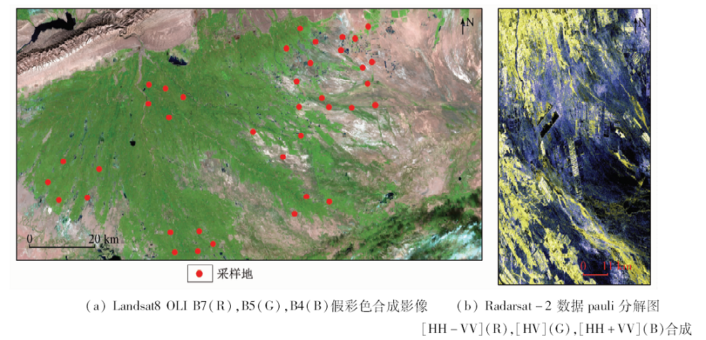
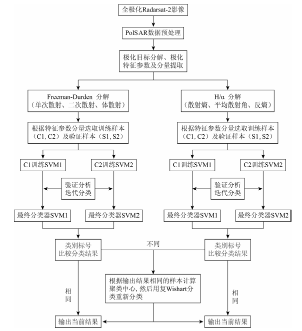
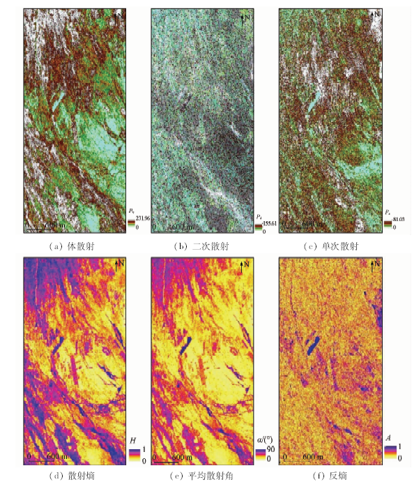
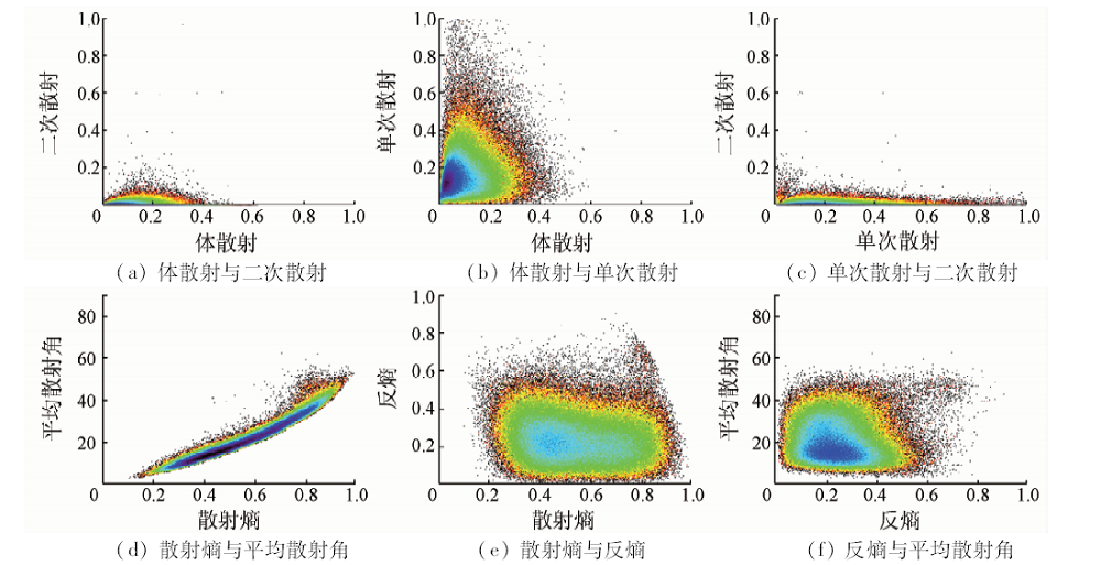
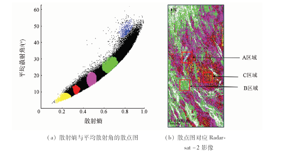
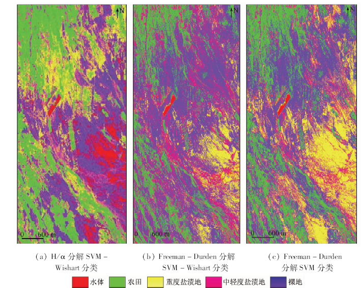
Abstract With Weiku oasis in Xinjiang as the study area, the authors used two polarization methods, i.e., Freeman-Durden and H/α, to decompose and treat 4-polarization data of the Radarsat-2, got the corresponding characteristic parameters, extracted the salinization information of the study area combined with the SVM-Wishart semi-supervised classification method, and finally checked and analyzed the result of the classification with the visual interpretation and the field investigation. Some conclusions have been reached: ① When the impact categories are identified and the parameter feature space is built to get the characteristic parameters, different polarization decompositions yield different resolutions of parameter information, and the distributions of parameters characteristic space are different; after decomposing with H/α, the characteristic space constituted by characteristic parameters are different; ② The effect of using semi-supervised classification method to classify the endings of the Freeman Durden and H/α,Freeman Durden classification is superior to that of H/a; ③SVM-Wishart semi-supervised classification is superior to traditional SVM classification and hence it can be well used to extract the salinization information. SVM-Wishart semi-supervised classification can fully excavate the characteristic parameters after the coherent decomposition of polarization and can improve the classification accuracy, and it has certain advantages in the extraction of salinization information.
|
| Keywords
soil salinization
polarization decomposition
Radarsat-2 data
SVM-Wishart classification
|
|
|
|
Corresponding Authors:
Jianli DING
E-mail: ding_jl@163.com
|
|
Issue Date: 14 March 2019
|
|
|
| [1] |
丁建丽, 姚远, 王飞 , 等. 干旱区土壤盐渍化特征空间建模[J]. 生态学报, 2014,34(16):4620-4631.
doi: 10.5846/stxb201212291895
url: http://www.cnki.com.cn/Article/CJFDTotal-STXB201416019.htm
|
| [1] |
Ding J L, Yao Y, Wang F , et al. Detecting soil salinization in arid regions using spectralfeature space derived from remote sensing data[J]. Acta Ecologica Sinica, 2014,34(16):4620-4631.
|
| [2] |
Muyen Z, Moore G A, Wrigley R J . Soil salinity and sodicity effects of wastewater irrigation in South East Australia[J]. Agricultural Water Management, 2011,99(1):33-41.
doi: 10.1016/j.agwat.2011.07.021
url: https://linkinghub.elsevier.com/retrieve/pii/S0378377411001880
|
| [3] |
Wang H, Jia G . Satellite-based monitoring of decadal soil salinization and climate effects inasemi-arid region of China[J]. Advances in Atmospheric Sciences, 2012,29(5):1089-1099.
doi: 10.1007/s00376-012-1150-8
url: http://link.springer.com/10.1007/s00376-012-1150-8
|
| [4] |
曹雷, 丁建丽, 于海洋 . 渭—库绿洲多尺度景观格局与盐度关系[J]. 农业工程学报, 2016,32(3):101-110.
doi: 10.11975/j.issn.1002-6819.2016.03.015
url: http://d.wanfangdata.com.cn/Periodical/nygcxb201603016
|
| [4] |
Cao L, Ding J L, Yu H Y . Relationship between multi-scale landscape pattern and salinity in Weigan and Kuqa Rivers Delta oasis[J]. Transactions of the Chinese Society of Agricultural Engineering, 2016,32(3):101-110.
|
| [5] |
Bouksila F, Bahri A, Berndtsson R , et al. Assessment of soil salinization risks under irrigation with brackish water in semiarid Tunisia[J]. Environmental and Experimental Botany, 2013,92(5):176-185.
doi: 10.1016/j.envexpbot.2012.06.002
url: https://linkinghub.elsevier.com/retrieve/pii/S0098847212001402
|
| [6] |
吕云海 . 于田绿洲典型区域土壤盐分空间分异规律研究[D]. 乌鲁木齐:新疆大学, 2009.
|
| [6] |
Lyu Y H . The Research for Spatial Distribution Rules of the Soil Salt of Typical Area in Yutian Oasis[D]. Urumqi:Xinjiang University, 2009.
|
| [7] |
Farifteh J, Meer F V D, Atzberger Cs, et al. Quantitative analysis of salt-affected soil reflectance spectra:A comparison of two adaptive methods(PLSR and ANN)[J]. Remote Sensing of Environment, 2007,110(1):59-78.
doi: 10.1016/j.rse.2007.02.005
url: https://linkinghub.elsevier.com/retrieve/pii/S003442570700082X
|
| [8] |
Wang H, Hsieh Y P, Harwell M A , et al. Modeling soil salinity distribution along topographic gradients in tidal salt marshes in Atlantic and Gulf coastal regions[J]. Ecological Modelling, 2007,201(3-4):429-439.
doi: 10.1016/j.ecolmodel.2006.10.013
url: https://linkinghub.elsevier.com/retrieve/pii/S0304380006004959
|
| [9] |
Lonnqvist A, Rauste Y, Molinier M , et al. Polarimetric SAR data in land cover mapping in Boreal Zone[J]. IEEE Transactions on Geoscience and Remote Sensing, 2010,48(10):3652-3662.
doi: 10.1109/TGRS.2010.2048115
url: http://ieeexplore.ieee.org/document/5475228/
|
| [10] |
Nurmemet I, Ghulam A, Tiyip T , et al. Monitoring soil salinization in Keriya River Basin,Northwestern China using passive reflective and active microwave remote sensing data[J]. Remote Sensing, 2015,7(7):8803-8829.
doi: 10.3390/rs70708803
url: http://www.mdpi.com/2072-4292/7/7/8803
|
| [11] |
Shi J, Chen K S, Li Q , et al. A parameterized surface reflectivity model and estimation of bare-surface soil moisture with L-band radiometer[J]. Remote Sensing, 2010,40(12):2674-2686.
doi: 10.1109/TGRS.2002.807003
url: http://ieeexplore.ieee.org/xpls/icp.jsp?arnumber=1176158
|
| [12] |
Metternicht G I . Fuzzy classification of JERS-1 SAR data: An evaluation of its performance for soil salinity mapping[J]. Ecological Modelling, 1998,111(1):61-74.
doi: 10.1016/S0304-3800(98)00095-7
url: http://linkinghub.elsevier.com/retrieve/pii/S0304380098000957
|
| [13] |
Lhissou R, Chokmani K, El Harti A, et al. Soil salinity estimation using RADARSAT 2 polarimetric data in arid and sub-arid regions:Morocco and Tunisia cases[C]// EGU General Assembly Conference.Vienna:EGU, 2013.
|
| [14] |
Li Y Y, Zhao K, Ding Y L, et al. An empirical method for soil salinity and moisture inversion in west of Jilin[C]// Proceedings of the International Conference on Remote Sensing Environment and Transportation Engineering(RSETE).Nanjing:AISR, 2013: 19-21.
|
| [15] |
Deng L, Yan Y N, Wang C Z . Improved POLSAR image classification by the use of multi-feature combination[J]. Remote Sensing, 2015,7(4):4157-4177.
doi: 10.3390/rs70404157
url: http://www.mdpi.com/2072-4292/7/4/4157
|
| [16] |
Qi Z X, Yeh G O, Li X , et al. A novel algorithm for land use and land cover classification using RADARSAT-2 polarimetric SAR data[J]. Remote Sensing of Environment, 2012,118:21-39.
doi: 10.1016/j.rse.2011.11.001
url: https://linkinghub.elsevier.com/retrieve/pii/S0034425711003877
|
| [17] |
丁建丽, 张飞, 江红南 , 等. 塔里木盆地北缘绿洲土壤含盐量和电导率空间变异性研究——以渭干河—库车河三角洲绿洲为例[J]. 干旱区地理, 2008,31(4):624-632.
url: http://d.wanfangdata.com.cn/Periodical/ghqdl200804022
|
| [17] |
Ding J L, Zhang F, Jiang H N , et al. Spatial variability of soil conductivity and salt content in the north Tarim Basin:A case study in the delta oasis of Weigen-Kuqa Rivers[J]. Arid Land Geography, 2008,31(4):624-632.
|
| [18] |
姚远, 丁建丽, 雷磊 , 等. 干湿季节下基于遥感和电磁感应技术的塔里木盆地北缘绿洲土壤盐分的空间变异性[J]. 生态学报, 2013,33(17):5308-5319.
doi: 10.5846/stxb201205230766
url: http://www.cqvip.com/qk/90772x/201317/46970502.html
|
| [18] |
Yao Y, Ding J L, Lei L , et al. Monitoring spatial variability of soil salinity in dry and wet seasons in the North Tarim Basin using remote sensing and electromagnetic induction instruments[J]. Acta Ecologica Sinica, 2013,33(17):5308-5319.
|
| [19] |
丁建丽, 姚远, 王飞 . 基于三维光谱特征空间的干旱区土壤盐渍化遥感定量研究[J]. 土壤学报, 2013,50(5):853-861.
doi: 10.11766/trxb201212290535
url: http://d.wanfangdata.com.cn/Periodical/trxb201305001
|
| [19] |
Ding J L, Yao Y, Wang F . Quantitative remote sensing of soil salinization in arid regions based on three dimensional spectrum eigen spaces[J]. Acta Pedologica Sinica, 2013,50(5):853-861.
|
| [20] |
Allbed A, Kumar L, Aldakheel Y Y . Assessing soil salinity using soil salinity and vegetation indices derived from IKONOS high-spatial resolution imageries:Applications in a date palm dominated region[J]. Geoderma, 2014, 230-231(7):1-8.
doi: 10.1016/j.geoderma.2014.03.025
url: https://linkinghub.elsevier.com/retrieve/pii/S0016706114001372
|
| [21] |
Cloude S R, Pottier E . An entropy based classification scheme for land applications of polarimetric SAR[J]. IEEE Transactions on Geoscience and Remote Sensing, 1997,35(1):68-78.
doi: 10.1109/36.551935
url: http://ieeexplore.ieee.org/document/551935/
|
| [22] |
Lee J S, Grunes M R, Pottier E , et al. Unsupervised terrain classification preserving polarimetric scattering characteristics[J]. IEEE Transactions on Geoscience and Remote Sensing, 2004,42(4):722-731.
doi: 10.1109/TGRS.2003.819883
url: http://ieeexplore.ieee.org/document/1288367/
|
| [23] |
Lee J S, Grunes M R . Classification of multi-look polarimetric SAR data based on complex Wishart distribution[J]. International Journal of Remote Sensing, 1992,15(11):2299-2311.
doi: 10.1080/01431169408954244
url: http://ieeexplore.ieee.org/iel2/630/6694/00267879.pdf
|
|
Viewed |
|
|
|
Full text
|
|
|
|
|
Abstract
|
|
|
|
|
Cited |
|
|
|
|
| |
Shared |
|
|
|
|
| |
Discussed |
|
|
|
|
 2019,
Vol. 31
2019,
Vol. 31