|
|
 |
|

|
|
|
The application of real scene model to digital museum of traditional villages |
| Jiajun LI, Hui XU, Dawei ZHAO |
| Academic Information Center, China Academy of Urban Planning & Design, Beijing 100044, China |
|
|
|
|
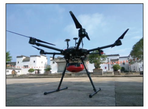
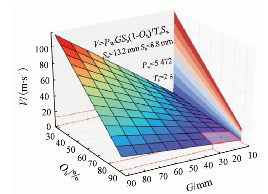
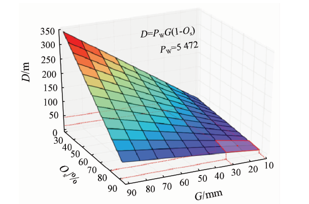
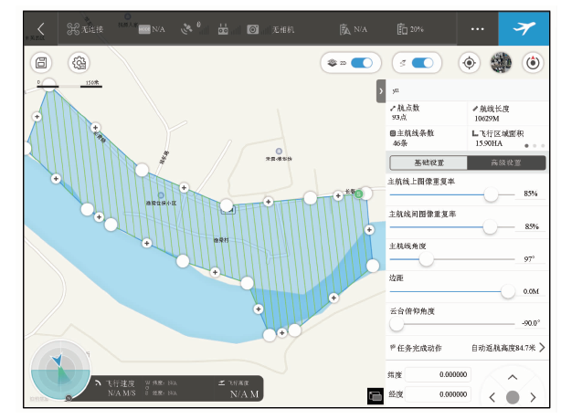
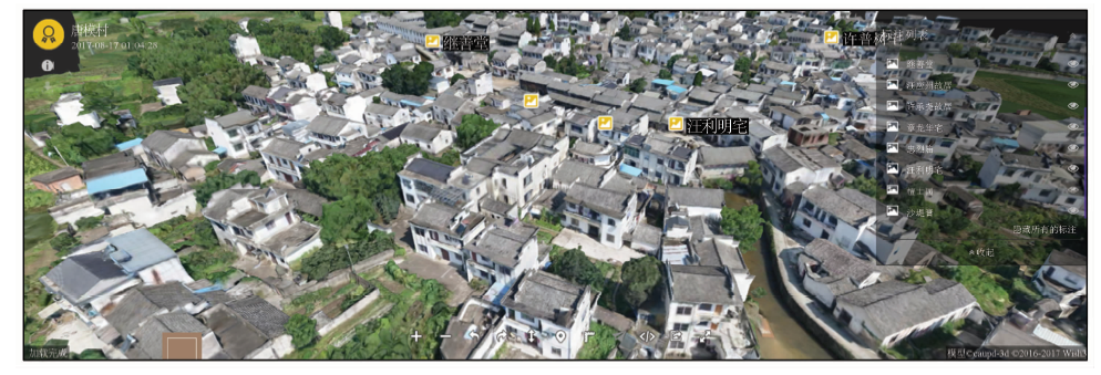
Abstract Using three-dimensional landscape modeling to do traditional village digitization has the advantages of high efficiency and reduction degree. By launching the reconstruction of 13 villages in southern Anhui, with multi-rotor aircraft which carries five cameras to complete the villages’ image data acquisition and preprocessing and, in combination with ContextCapture software to complete aerial triangulation and reconstruction, the model of village model is finally acquired and the model window is transferred and used in the website of the digital museum of the traditional village of China. The results show that this method can be applied to village of model building, and automatically produce dioramas with high resolution, good topological relations and rich details, thus playing an important role in the construction of digital museum of Chinese traditional village. Through the analysis of the data processing time of multiple villages, the authors have obtained the intrinsic relationship between aerial triangulation calculating time and data acquisition time, and give some suggestions on the implementation of the aerial task under the context of traditional villages.
|
| Keywords
3D scene model
traditional villages
ContextCapture
route planning
model reconstruction
|
|
|
|
Issue Date: 14 March 2019
|
|
|
| [1] |
王桂娟, 徐铁权 . 美丽乡村建设中的传统村落文化保护[J]. 河南农业, 2017,23(8):58-60.
url: http://www.cnki.com.cn/Article/CJFDTotal-CSDI201802143.htm
|
| [1] |
Wang G J, Xu T Q . The protection of traditional villages in the construction of beautiful countryside[J]. Agriculture of Henan, 2017,28(8):58-60.
|
| [2] |
陈继腾 . 传统村落保护发展应关注的问题和建议——以黄山市传统村落为例[J]. 安徽建筑, 2015,22(4):14-15.
doi: 10.16330/j.cnki.1007-7359.2015.04.002
url: http://www.cqvip.com/QK/90950X/201504/665807193.html
|
| [2] |
Chen J T . Issues and suggestions needing attention in protection and development of traditional village[J]. Anhui Architecture, 2015,22(4):14-15.
|
| [3] |
王军, 夏健 . 传统村落保护的动态监控体系建构研究[J]. 城市发展研究, 2016,23(7):58-63.
url: http://www.cqvip.com/QK/90379X/201607/669684659.html
|
| [3] |
Wang J, Xia J . Research on the construction of dynamic monitoring system of the protection of traditional village[J]. Urban Development Studies, 2016,23(7):58-63.
|
| [4] |
张福友 . 基于大疆无人机的Context Capture三维实景建模探讨[J]. 广东水利水电, 2017,46(8):88-91.
url: http://www.cqvip.com/QK/94772A/201708/672902193.html
|
| [4] |
Zhan F Y . Real 3D modeling with Context Capture base on DJI UAV[J]. Guangdong Water Resources and Hydropower, 2017,46(8):88-91.
|
| [5] |
李伟哲 . 基于ContextCapture实景建模及应用[J]. 西北水电, 2018(3):27-31.
url: http://www.cnki.com.cn/Article/CJFDTotal-SBXX201803008.htm
|
| [5] |
Li W Z . Scenic modeling and application based on ContextCapture[J]. Northwest Hydropower, 2018(3):27-31.
|
| [6] |
赵明 . Pix4D mapper软件在无人机航空摄影与工程地质调查中的数据处理[J]. 水电站设计, 2017,33(2):47-48,62.
url: http://d.wanfangdata.com.cn/Periodical/sdzsj201702014
|
| [6] |
Zhao M . Data processing of Pix4D mapper in UAV aerial photography and engineering geological survey[J]. Design of Hydroelectric Power Station, 2017,33(2):47-48,62.
|
| [7] |
李亚星 . Smart 3D在风景园林测绘中的应用[J]. 现代园艺, 2017,40(2):126.
url: http://d.wanfangdata.com.cn/Periodical/jiangxyy201702099
|
| [7] |
Li Y X . Application of smart 3D in landscape architecture surveying[J]. Xiandai Horticulture, 2017,40(2):126.
|
| [8] |
刘尚蔚, 王维洋, 魏群 . 三维实景建模技术及其应用[J]. 中国水运, 2016,16(11):132-134.
url: http://d.wanfangdata.com.cn/Periodical/zgsy-xby201611050
|
| [8] |
Liu S W, Wang W Y, Wei Q . Real three-dimensional modeling and application[J]. China Water Transport, 2016,16(11):132-134.
|
|
Viewed |
|
|
|
Full text
|
|
|
|
|
Abstract
|
|
|
|
|
Cited |
|
|
|
|
| |
Shared |
|
|
|
|
| |
Discussed |
|
|
|
|
 2019,
Vol. 31
2019,
Vol. 31