|
|
|
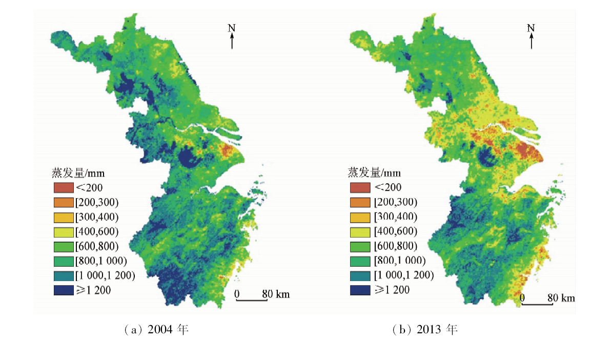
Abstract The evapotranspiration in the Jiangsu-Zhejiang-Shanghai Area during the 2004 and 2013 growing seasons was estimated by integrating the MODIS remote sensing data and using the Surface Energy Balance Algorithm for Land (SEBAL) model, and the model was validated using the surface observation data of the lysimeter. On the basis of summarizing the evapotranspiration time-space expansion method, the crop volatility method was used to expand the regional evapotranspiration on the monthly and seasonal scales, and the evapotranspiration of the regional monthly and seasonal scales was calculated. The results show that the SEBAL model is more suitable for evapotranspiration estimation in this region. The evapotranspiration range of the annual growing season in the Jiangsu-Zhejiang-Shanghai Area is wider, and the southern evapotranspiration is higher in the region. The average evapotranspiration in the regional growing season in 2013 was 758 mm. It was lower than the average evapotranspiration of about 930 mm in the growing season in 2004 . According to the statistics of the average daily evapotranspiration of the growing seasons, the authors have found that the natural land use evapotranspiration of the Jiangsu-Zhejiang-Shanghai Area is higher than that of the artificial land use, while in natural land use, the evapotranspiration is in order of water>forest>beach land>grassland>unused land. For artificial land use, the evapotranspiration of urban area is significantly low, while the evapotranspiration values of paddy fields, dry land and rural area are relatively high, and the difference is insignificant.
|
| Keywords
MODIS remote sensing data
Jiangsu-Zhejiang-Shanghai Area
SEBAL algorithm
evapotranspiration
spatial evapotranspiration pattern
|
|
|
|
Corresponding Authors:
Lu HAO
E-mail: hl_haolu@163.com
|
|
Issue Date: 18 June 2020
|
|
|
| [1] |
Jiang L, Islam S, Guo W, et al. A satellite-based daily actual evapotranspiration estimation algorithm over South Florida[J]. Global and Planetary Change, 2009,67(1-2):62-77.
doi: 10.1016/j.gloplacha.2008.12.008
url: https://linkinghub.elsevier.com/retrieve/pii/S0921818108002099
|
| [2] |
田文婷, 王飞, 王新, 等. 钱塘江流域蒸散发遥感估算[J]. 浙江水利科技, 2015,43(6):84-89.
|
| [2] |
Tian W T, Wang F, Wang X, et al. Evapotranspiration remote sensing estimation of Qiantang River[J]. Zhejiang Hydrotecnics, 2015,43(6):84-89.
|
| [3] |
张雨航, 王晓林, 胡光成. 基于MODIS数据的海流兔河流域蒸散量的计算[J]. 地球科学, 2012,37(2):375-380.
|
| [3] |
Zhang Y H, Wang X L, Hu G C. Evapotranspiration estimation of Hailiu River Basin based on MODIS data[J]. Earth Science—Journal of China University of Geosciences, 2012,37(2):375-380.
|
| [4] |
韩松俊, 张宝忠. 基于Penman方法和互补原理的蒸散发研究历程与展望[J]. 水利学报, 2018,49(9):1158-1168.
|
| [4] |
Han S J, Zhang B Z. Advances of evapotraspiration research based on the Penman approach and complementary principle[J]. Journal of Hydraulic Engineering, 2018,49(9):1158-1168.
|
| [5] |
Penman H L. Natural evaporation from open water,bare soil and grass[J]. Proceedings of the Royal Society of London, 1948,193(1032):120-145.
|
| [6] |
Monteith J I L. Evaporation and environment[J]. Symposia of the Society for Experimental Biology, 1965,19:205-234.
|
| [7] |
Cai J, Liu Y, Lei T, et al. Estimating reference evapotranspiration with the FAO Penman-Monteith equation using daily weather forecast messages[J]. Agricultural and Forest Meteorology, 2007,145(1-2):22-35.
|
| [8] |
Wilm H G, Thornthwaite C W, Colman E A, et al. Report of the committee on transpiration and evaporation,1943—44[J]. Eos Transactions American Geophysical Union, 1944,25(5):683-693.
|
| [9] |
Swinbank W. The measurement of vertical transfer of heat and water vapor by eddy the lower atmosphere[J]. Meteorol, 1951,8(3):135-145.
|
| [10] |
张荣华, 杜君平, 孙睿. 区域蒸散发遥感估算方法及验证综述[J]. 地球科学进展, 2012,27(12):1295-1307.
|
| [10] |
Zhang R H, Du J P, Sun R. Review of estimation and validation of regional evapotranspiration based on remote sensing[J]. Advances in Earth Science, 2012,27(12):1295-1307.
|
| [11] |
姚云军, 程洁, 赵少华, 等. 基于热红外遥感的农田蒸散估算方法研究综述[J]. 地球科学进展, 2012,27(12):1308-1318.
|
| [11] |
Yao Y J, Cheng J, Zhao S H, et al. Estimation of farmland evapotranspiration:A review of methods using thermal infrared remote sensing data[J]. Advances in Earth Science, 2012,27(12):1308-1318.
|
| [12] |
Bhattarai N, Shaw S B, Quackenbush L J, et al. Evaluating five remote sensing based single-source surface energy balance models for estimating daily evapotranspiration in a humid subtropical climate[J]. International Journal of Applied Earth Observation & Geoinformation, 2016,49:75-86.
|
| [13] |
Bastiaanssen W G M. SEBAL-based sensible and latent heat fluxes in the irrigated Gediz Basin,Turkey[J]. Journal of Hydrology(Amsterdam), 2000,229(1-2):87-100.
|
| [14] |
Hao L, Sun G, Liu Y Q, et al. Urbanizaiton dramatically altered the water balances of a paddy field-dominated basin in southern China[J]. Hydrology and Earth System Sciences, 2015,19(7):3319-3331.
|
| [15] |
Hao L, Huang X L, Qin M S, et al. Ecohydrological processes explain urban dry island effects in a wet region,southern China[J]. Water Resources Research, 2018,54(9):6757-6771.
|
| [16] |
冯天梅. 基于SEBAL模型的青海省东部农业区蒸散发量的遥感估算研究[D]. 杨凌:西北农林科技大学, 2015: 13-14.
|
| [16] |
Feng T M. Study of Evapotranspiration estimaition by remote sensing of eastern agricultural area in Qinghai Province based on SEBAL model[D]. Yang Ling:Northwest F&A University, 2015: 13-14.
|
| [17] |
刘志红 Li L T, Mcvicar T R, et al. 专用气候数据空间插值软件ANUSPLIN及其应用[J]. 气象, 2008,34(2):92-100.
|
| [17] |
Liu Z H, Li L T, Mcvicar T R, et al. Introduction of the professional interpolataion software for meteorlogy data:ANUSPLIN[J]. Meteorlogical Monthly, 2008,34(2):92-100.
|
| [18] |
Raúl E.Rivas, Carmona F. Evapotranspiration in the Pampean Region using field measurements and satellite data[J]. Physics and Chemistry of the Earth Parts A/B/C, 2013,55(2):27-34.
|
| [19] |
Du J, Song K S, Wang Z M, et al. Evapotranspiration estimation based on MODIS products and surface energy balance algorithms for land mdoel in Sanjiang Plain northeast China[J]. Chinese Geographical Science, 2013,23:73-91.
|
| [20] |
吴桂平, 刘元波, 赵晓松, 等. 基于MOD16产品的鄱阳湖流域地表蒸散量时空分布特征[J]. 地理研究, 2013,32(4):617-627.
|
| [20] |
Wu G P, Liu Y B, Zhao X S, et al. Spatial-temporal variation of evapotranspiration in Poyang Lake Basin using MOD16 products[J]. Geographical Rsearch, 2013,32(4):617-627.
|
| [21] |
Li X, He Y, Zeng Z, et al. Spatiotemporal pattern of terrestrial evapotranspiration in China during the past thirty years[J]. Agricultural & Forest Meteorology, 2018,259:131-140.
|
| [22] |
杨泽粟, 张强, 郝小翠, 等. 黄土高原地表蒸散量估算及其空间分布分析[C]//中国气象学会年会s12大气物理学与大气环境. 2014: 239-256.
|
| [22] |
Yang L Z, Zhang Q, Hao X C, et al. Estimation of surface evapotranspiration and spatial distribution analysis in Loess Plateau[C]// Annual meeting of China Meteorological Society s12 Annual meeting of China Meteorological Society. 2014: 239-256.
|
| [23] |
冯飞, 姚云军, 张彦彬, 等. 基于MOD16产品的三江平原蒸散量时空分布特征分析[J]. 生态环境学报, 2015,24(11):1858-1864.
|
| [23] |
Feng F, Yao Y J, Zhang Y B, et al. Spatio-temporal variations of evapotranspiration in Sanjiang Plain using MOD16 products[J]. Ecology and Environmental Sciences, 2015,24(11):1858-1864.
|
| [24] |
杜嘉, 张柏, 宋开山, 等. 基于NOAA/AVHRR数据估算三江平原蒸散量研究初探[J]. 水土保持研究, 2009,16(2):56-62.
|
| [24] |
Du J, Zhang B, Song K S, et al. Estimated evapotranspiration based on NOAA/AVHRR data in the Sanjiang Plain[J]. Research of Soil and Water Conservation, 2009,16(2):56-62.
|
| [25] |
黄飞羽, 何彬方, 汪翔, 等. 基于MOD16的安徽省蒸散时空分布特征研究[J]. 农业科学与技术:英文版, 2017,18(11):2092-2097.
|
| [25] |
Huang F Y, He B F, Wang X, et al, Spatio-temporal variations of evapotranspiration in Anhui Province based on MOD16 products[J]. Agricultural Science & Technology, 2017,18(11):2092-2097.
|
| [26] |
Timmermans W J, Kustas W P, Anderson M C, et al. An intercomparison of the surface energy balance algorithm for land(SEBAL) and the two-source energy balance(TSEB) modeling schemes[J]. Remote Sensing of Environment, 2007,108(4):369-384.
doi: 10.1016/j.rse.2006.11.028
url: https://linkinghub.elsevier.com/retrieve/pii/S0034425706005013
|
| [27] |
Yang Y, Shang S, Jiang L. Remote sensing temporal and spatial patterns of evapotranspiration and the responses to water management in a large irrigation district of North China[J]. Agricultural and Forest Meteorology, 2012,164:112-122.
doi: 10.1016/j.agrformet.2012.05.011
url: http://dx.doi.org/10.1016/j.agrformet.2012.05.011
|
| [28] |
周彦昭, 周剑, 李妍, 等. 利用SEBAL和改进的SEBAL模型估算黑河中游戈壁、绿洲的蒸散发[J]. 冰川冻土, 2014,36(6):1526-1537.
doi: 10.7522/j.issn.1000-0240.2014.0183
url: http://bcdt.westgis.ac.cn/CN/abstract/abstract3549.shtml
|
| [28] |
Zhou Y Z, Zhou J, Li Y, et al. Simulating the evapotranspiration with SEBAL and modified SEBAL(M-SEBAL) models over the desert and oasis of the middle reaches of the Heihe River[J]. Journal of Glaciology and Geocryology, 2014,36(6):1526-1537.
doi: 10.7522/j.issn.1000-0240.2014.0183
url: http://bcdt.westgis.ac.cn/CN/abstract/abstract3549.shtml
|
| [29] |
Sun Z, Wei B, Su W, et al. Evapotranspiration estimation based on the SEBAL model in the Nansi Lake Wetland of China[J]. Mathematical & Computer Modelling, 2011,54(3):1086-1092.
|
| [30] |
杜嘉, 张柏, 宋开山, 等. 基于MODIS产品和SEBAL模型的三江平原日蒸散量估算[J]. 中国农业气象, 2010,31(1):104-110.
url: http://zgnyqx.ieda.org.cn//CN/abstract/abstract1003.shtml
|
| [30] |
Du J, Zhang B, Song K S, et al. Study on daily evapotranspiration estimation of Sanjiang Plain based on MODIS product and SEBAL model[J]. Chinese Journal of Agrometeorology, 2010,31(1):104-110.
url: http://zgnyqx.ieda.org.cn//CN/abstract/abstract1003.shtml
|
| [31] |
Li Z, Liu X, Ma T, et al. Retrieval of the surface evapotranspiration patterns in the alpine grassland-wetland ecosystem applying SEBAL model in the source region of the Yellow River,China[J]. Ecological Modelling, 2013,270:64-75.
doi: 10.1016/j.ecolmodel.2013.09.004
url: https://linkinghub.elsevier.com/retrieve/pii/S030438001300433X
|
|
Viewed |
|
|
|
Full text
|
|
|
|
|
Abstract
|
|
|
|
|
Cited |
|
|
|
|
| |
Shared |
|
|
|
|
| |
Discussed |
|
|
|
|
 2020,
Vol. 32
2020,
Vol. 32
 )
)