|
|
 |
|

|
|
|
Temporal and spatial dynamics of spring drought in Qinghai-Tibet region based on VCI index |
JI Min1( ), ZHANG Chao1, ZHAO Jianwei1, YAN Juan2, LIANG Liang2 ), ZHANG Chao1, ZHAO Jianwei1, YAN Juan2, LIANG Liang2 |
1. College of Geomatics,Shandong University of Science and Technology, Qingdao 266590, China
2. School of Geography, Geomatics and Planning, Jiangsu Normal University, Xuzhou 221116, China |
|
|
|
|
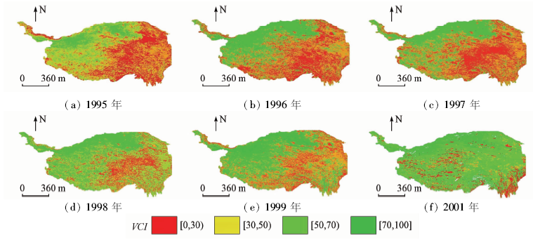
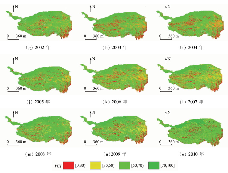
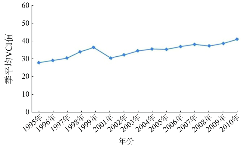
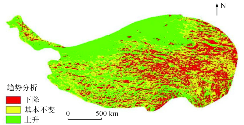
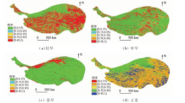
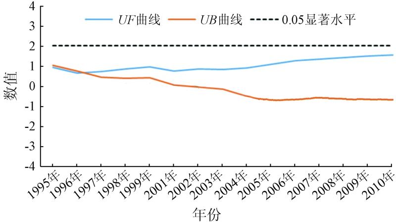
Abstract The spatial-temporal characteristics of spring drought are very important for decision-making and many agricultural applications. In this study, the spatial-temporal analysis of vegetation drought in Qinghai-Tibet region from 1995 to 2010 was carried out by using the vegetation state index of NOAA. According to the characteristics of VCI as a drought index, a variety of methods were used, which included frequency analysis, trend analysis and man Kendall experiment. The results show that the Qinghai-Tibet Region is less affected by monsoon, the frequency of drought in Hengduan Mountain and Qilian Mountain is relatively low, and most of the droughts are light and medium drought. According to the analysis, the trend of drought in this area is not unidirectional and can be divided into two stages. Before 2000, the VCI index was relatively high, and the volatility was relatively large; after 2000, the VCI index was relatively low, and relatively stable.
|
| Keywords
spring drought
VCI
Mann-Kendall experiment
|
|
|
|
Issue Date: 18 March 2021
|
|
|
| [1] |
唐侥, 孙睿. 基于气象和遥感数据的河南省干旱特征分析[J]. 自然资源学报, 2013,28(4):646-655.
doi: 10.11849/zrzyxb.2013.04.011
url: http://www.jnr.ac.cn/CN/abstract/abstract2608.shtml
|
| [1] |
Tang Y, Sun R. Drought characteristics in Henan Province with meteorological and remote sensing data[J]. Journal of Natural Resources, 2013,28(4):646-655.
doi: 10.11849/zrzyxb.2013.04.011
url: http://www.jnr.ac.cn/CN/abstract/abstract2608.shtml
|
| [2] |
孙丽, 陈焕伟, 赵立军, 等. 遥感监测旱情的研究进展[J]. 农业环境科学学报, 2004,23(1):202-206.
|
| [2] |
Sun L, Chen H W, Zhao L J, et al. The advances of drought monitoring by remote sensing[J]. Journal of Agro-Environment Science, 2004,23(1):202-206.
|
| [3] |
杨波, 马苏, 王彬武, 等. 基于MODIS的湖南省农业干旱监测模型[J]. 自然资源学报, 2012,27(10):1788-1796.
|
| [3] |
Yang B, Ma S, Wang B W, et al. Agricultural drought monitoring model based on MODIS data in Hunan Province[J]. Journal of Natural Resources, 2012,27(10):1788-1796.
|
| [4] |
Yilmaz M T, Hunt E R, Jackson T J. Remote sensing of vegetation water content from equivalent water thickness using satellite imagery[J]. Remote Sensing of Environment, 2008,112(5):2514-2522.
doi: 10.1016/j.rse.2007.11.014
url: https://linkinghub.elsevier.com/retrieve/pii/S0034425707004798
|
| [5] |
Kogan F N. Droughts of the late 1980s in the United States as derived from NOAA polar-orbiting satellite data[J]. Bulletin of the American Meteorological Society, 1995,76(5):655-668.
doi: 10.1175/1520-0477(1995)076<0655:DOTLIT>2.0.CO;2
url: http://journals.ametsoc.org/doi/10.1175/1520-0477(1995)076<0655:DOTLIT>2.0.CO;2
|
| [6] |
Sahoo A K, Sheffield J, Pan M, et al. Evaluation of the tropical rainfall measuring mission multi-satellite precipitation analysis (TMPA) for assessment of large-scale meteorological drought[J]. Remote Sensing of Environment, 2015,159:181-193.
doi: 10.1016/j.rse.2014.11.032
url: https://linkinghub.elsevier.com/retrieve/pii/S003442571400488X
|
| [7] |
Di L P, Rundquist D C, Han L H. Modeling relationships between NDVI and precipitation during vegetative growth cycles[J]. International Journal of Remote Sensing, 1994,15(10):2121-2136.
doi: 10.1080/01431169408954231
url: https://www.tandfonline.com/doi/full/10.1080/01431169408954231
|
| [8] |
Kogan F, Sullivan J. Development of global drought- watch system using NOAA/AVHRR data[J]. Advances in Space Research, 1993,13(5):219-222.
|
| [9] |
Gitelson A A, Kogan F N, Zakarin E, et al. Using AVHRR data for quantitative estimationof vegetation conditions:Calibration and validation[J]. Advance in Space Research, 1998,22:673-676.
|
| [10] |
Burgan R E, Hartford R A. Monitoring vegetation greenness with satellite data[R]. United States Department of Agriculture,Forest Service,Intermountain Research Station, 1993.
|
| [11] |
Kogan F N. Operational space technology for global vegetation assessment[J]. Bulletin of the American Meteorological Society, 2001,82(9):1949-1964.
|
| [12] |
孙亲. 基于VCI指数的中国1981—2015年干旱时空变化特征研究[D]. 徐州:江苏师范大学, 2017.
|
| [12] |
Sun Q. Study on spatial-temporal characteristics of drought in China during 1981—2015 based on VCI[D]. Xuzhou:Jiangsu Normal University, 2017.
|
| [13] |
吕潇然, 尹晓天, 宫阿都, 等. 基于植被状态指数的云南省干旱状况时空分析[J]. 地球科学信息学报, 2016,18(12):1634-1644.
|
| [13] |
Lyu X R, Yin X T, Gong E D, et al. Temporal and spatial analysis of agricultural drought in Yunnan Province based on vegetation condition index[J]. Journal of Geoinformation Science, 2016,18(12):1634-1644.
|
| [14] |
李新尧, 杨联安, 聂红梅, 等. 基于植被状态指数的陕西省农业干旱时空动态[J]. 生态学杂志, 2018,37(4):1172-1180.
|
| [14] |
Li X Y, Yang L A, Nie H M, et al. Assessment of temporal and spatial dynamics of agricultural drought in Shaanxi Province based on vegetation condition index[J]. Chinese Journal of Ecology, 2018,37(4):1172-1180.
|
|
Viewed |
|
|
|
Full text
|
|
|
|
|
Abstract
|
|
|
|
|
Cited |
|
|
|
|
| |
Shared |
|
|
|
|
| |
Discussed |
|
|
|
|
 2021,
Vol. 33
2021,
Vol. 33