|
|
|
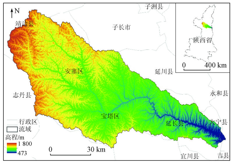
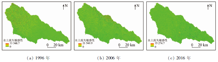
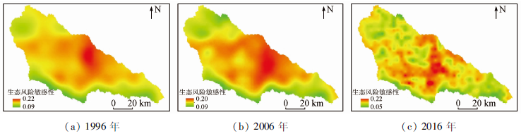
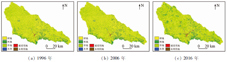
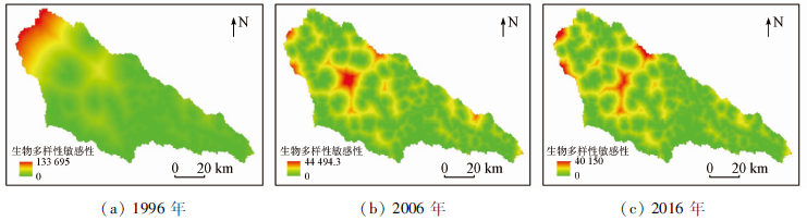
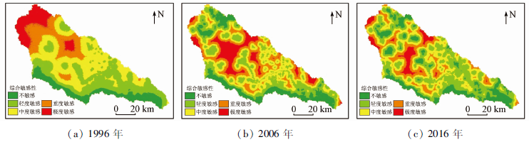
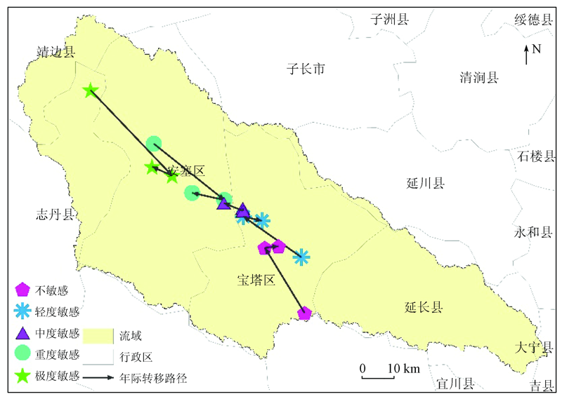
Abstract Ecological sensitivity refers to the sensitive degree of an ecosystem to the changes in the natural environment and the interference of human activities. It can be used to reflect the liable degree and possibility of the occurrence of ecological environmental problems. Taking the Yanhe River basin in the loess hilly and gully region as an example, this study selected three quantitative assessment indicators (i.e., sensitivity indices of soil erodibility, ecological risks, and biodiversity) to construct a composite environmental sensitivity index (CESI) based on spatial distance index for a river basin. Then it explored the temporal-spatial changes in the ecological sensitivity of the Yanhe River basin during 1996—2016 by combining the center of gravity model, obtaining the following results. ①From the perspective of temporal change, the ecological sensitivity in the Yanhe River basin during 1996—2016 showed a downward trend, with CESI increasing from 1.38 in 1996 to 1.41 in 2016. This indicates that the quality of the ecological environment in the Yanhe River basin improved during the period. ② From the perspective of spatial change, the spatial distribution of the ecological sensitivity in the Yanhe River basin greatly changed during 1996—2016. In detail, the areas with high ecological sensitivity were concentrated in the upper reaches in 1996 but were mainly distributed in the middle and lower reaches after 2006. ③ The center of gravity of the ecologically sensitive areas at all levels shifted toward the middle reaches during 1996—2016. Meanwhile, the ecologically sensitive areas were distributed in a concentrated way in 1996 but in a both concentrated and dispersed manner in 2016. ④ The ecological sensitivity in the Yanhe River basin was greatly affected by land use. The project of returning farmland to forest (grass) and comprehensive management project in the Yanhe River basin played a key role in the process of reducing ecological sensitivity.
|
| Keywords
ecological sensitivity
temporal-spatial changes
spatial distance index
center of gravity model
Yanhe River basin
|
|
|
|
Corresponding Authors:
ZHANG Yanfang
E-mail: 282166536@qq.com;zhangyf@snnu.edu.cn
|
|
Issue Date: 24 September 2021
|
|
|
| [1] |
许妍, 高俊峰, 赵家虎, 等. 流域生态风险评价研究进展[J]. 生态学报, 2012, 32(1):284-292.
|
| [1] |
Xu Y, Gao J F, Zhao J H, et al. The research progress and prospect of watershed ecological risk assessment[J]. Acta Ecologica Sinica, 2012, 32(1):284-292.
doi: 10.5846/stxb
url: http://www.ecologica.cn/
|
| [2] |
张广创, 王杰, 刘东伟, 等. 基于GIS的锡尔河中游生态敏感性分析与评价[J]. 干旱区研究, 2020, 37(2):506-513.
|
| [2] |
Zhang G C, Wang J, Liu D W, et al. Analysis and evaluation of the ecological sensitivity in the middle reaches of the Syr Darya River based on GIS[J]. Arid Zone Research, 2020, 37(2):506-513.
|
| [3] |
李振亚, 魏伟, 周亮, 等. 基于空间距离指数的中国西北干旱内陆河流域生态敏感性时空演变特征——以石羊河流域为例[J]. 生态学报, 2019, 39(20):7463-7475.
|
| [3] |
Li Z Y, Wei W, Zhou L, et al. Temporal and spatial evolution of ecological sensitivity in arid inland river basins of northwest China based on spatial distance index:A case study of Shiyang River Basin[J]. Acta Ecologica Sinica, 2019, 39(20):7463-7475.
|
| [4] |
欧阳志云, 王效科, 苗鸿. 中国生态环境敏感性及其区域差异规律研究[J]. 生态学报, 2000, 20(1):9-12.
|
| [4] |
Ouyang Z Y, Wang X K, Miao H. China’s eco-environmental sensitivity and its spatial heterogeneity[J]. Acta Ecologica Sinica, 2000, 20(1):9-12.
|
| [5] |
李益敏, 管成文, 朱军. 基于GIS的星云湖流域生态敏感性评价[J]. 水土保持研究, 2017, 24(5):266-271,278.
|
| [5] |
Li Y M, Guan C W, Zhu J. GIS-based ecologocal sensitivity analysis in Xingyun Lake Basin[J]. Research of Soil and Water Conservation, 2017, 24(5):266-271,278.
|
| [6] |
钟林生, 唐承财, 郭华. 基于生态敏感性分析的金银滩草原景区旅游功能区划[J]. 应用生态学报, 2010, 21(7):1813-1819.
|
| [6] |
Zhong L S, Tang C C, Guo H. Tourism function zoning of Jinyintan grassland scenic area in Qinghai Province based on ecological sensitivity analysis[J]. Chinese Journal of Applied Ecology, 2010, 21(7):1813-1819.
|
| [7] |
刘春霞, 李月臣, 杨华, 等. 三峡库区重庆段生态与环境敏感性综合评价[J]. 地理学报, 2011, 66(5):631-642.
|
| [7] |
Liu C X, Li Y C, Yang H, et al. RS and GIS-based assessment for eco-environmental sensitivity of the Three Gorges Reservoir area of Chongqing[J]. Acta Geographica Sinica, 2011, 66(5):631-642.
|
| [8] |
颜磊, 许学工, 谢正磊, 等. 北京市域生态敏感性综合评价[J]. 生态学报, 2009, 29(6):3117-3125.
|
| [8] |
Yan L, Xu X G, Xie Z L, et al. Integrated assessment on ecological sensitivity for Beijing[J]. Acta Ecologica Sinica, 2009, 29(6):3117-3125.
|
| [9] |
杜腾飞, 齐伟, 朱西存, 等. 基于生态安全格局的山地丘陵区自然资源空间精准识别与管制方法[J]. 自然资源学报, 2020, 35(5):1190-1200.
|
| [9] |
Du T F, Qi W, Zhu X C, et al. Precise identification and control method of natural resources space based on ecological security pattern in mountainous hilly area[J]. Journal of Natural Resources, 2020, 35(5):1190-1200.
doi: 10.31497/zrzyxb.20200514
url: http://www.jnr.ac.cn/EN/10.31497/zrzyxb.20200514
|
| [10] |
王雅竹, 段学军. 生态红线划定方法及其在长江岸线中的应用[J]. 长江流域资源与环境, 2019, 28(11):2681-2690.
|
| [10] |
Wang Y Z, Duan X J. Ecological red line demarcation method and its application in the Yangtze River coastline[J]. Resources and Environment in the Yangtze Basin, 2019, 28(11):2681-2690.
|
| [11] |
刘军会, 高吉喜, 马苏, 等. 中国生态环境敏感区评价[J]. 自然资源学报, 2015, 30(10):1607-1616.
|
| [11] |
Liu J H, Gao J X, Ma S, et al. Evaluation of ecological sensitivity in China[J]. Journal of Natural Resources, 2015, 30(10):1607-1616.
|
| [12] |
杨月圆, 王金亮, 杨丙丰. 云南省土地生态敏感性评价[J]. 生态学报, 2008, 28(5):2253-2260.
|
| [12] |
Yang Y Y, Wang J L, Yang B F. Eco-sensitivity assessment of land in Yunnan Province[J]. Acta Ecologica Sinica, 2008, 28(5):2253-2260.
|
| [13] |
魏伟, 石培基, 周俊菊, 等. 基于区统计方法的石羊河流域土地生态敏感性评价[J]. 水土保持研究, 2015, 22(6):240-244.
|
| [13] |
Wei W, Shi P J, Zhou J J, et al. Land ecological sensitivity evaluation of Shiyang River basin based on zonal statistics[J]. Research of Soil and Water Conservation, 2015, 22(6):240-244.
|
| [14] |
王娇, 程维明, 祁生林, 等. 基于USLE和GIS的水土流失敏感性空间分析——以河北太行山区为例[J]. 地理研究, 2014, 33(4):614-624.
doi: 10.11821/dlyj201404002
|
| [14] |
Wang J, Cheng W M, Qi S L, et al. Sensitive evaluation and spatial analysis of soil and water loss based on USLE and GIS:Taking Taihang Mountain area of Hebei Province as an example[J]. Geographical Research, 2014, 33(4):614-624.
|
| [15] |
秦伟, 朱清科, 张岩. 基于GIS和RUSLE的黄土高原小流域土壤侵蚀评估[J]. 农业工程学报, 2009, 25(8):4,157-163.
|
| [15] |
Qin W, Zhu Q K, Zhang Y. Soil erosion assessment of small watershed in Loess Plateau based on GIS and RUSLE[J]. Transactions of the Chinese Society of Agricultal Engineering, 2009, 25(8):157-163.
|
| [16] |
徐兰, 罗维, 周宝同. 基于土地利用变化的农牧交错带典型流域生态风险评价——以洋河为例[J]. 自然资源学报, 2015, 30(4):580-590.
|
| [16] |
Xu L, Luo W, Zhou B T. Landscape ecological risk assessment of farming-pastoral ecozone based on land use change:A case study of the Yanghe Watershed,China[J]. Journal of Natural Resources, 2015, 30(4):580-590.
|
| [17] |
臧淑英, 梁欣, 张思冲. 基于GIS的大庆市土地利用生态风险分析[J]. 自然灾害学报, 2005, 14(4):141-145.
|
| [17] |
Zang S Y, Liang X, Zhang S C. GIS-based analysis of ecological risk on land-use in Daqing City[J]. Journal of Natural Disasters, 2005, 14(4):141-145.
|
| [18] |
傅丽华, 谢炳庚, 张晔, 等. 长株潭城市群核心区土地利用生态风险评价[J]. 自然灾害学报, 2011, 20(2):96-101.
|
| [18] |
Fu L H, Xie B G, Zhang Y, et al. Ecological risk assessment of land use in core area of Changsha-Zhuzhou-Xiangtan urban group[J]. Journal of Natural Disasters, 2011, 20(2):96-101.
|
| [19] |
黄木易, 何翔. 近20年来巢湖流域景观生态风险评估与时空演化机制[J]. 湖泊科学, 2016, 28(4):785-793.
|
| [19] |
Huang M Y, He X. Landscape ecological risk assessment and its mechanism in Chaohu Basin during the past almost 20 years[J]. Journal of Lake Science, 2016, 28(4):785-793.
|
| [20] |
苏海民, 何爱霞. 基于RS和地统计学的福州市土地利用分析[J]. 自然资源学报, 2010, 25(1):91-99.
|
| [20] |
Su H M, He A X. Analysis of land use based on RS and geostatistics in Fuzhou City[J]. Journal of Natural Resources, 2010, 25(1):91-99.
|
| [21] |
段艺芳, 任志远, 周晓, 等. 延安市土地生态风险时空格局演变研究[J]. 国土资源遥感, 2020, 32(1):120-129.doi: 10.6046/gtzyyg.2020.01.17.
doi: 10.6046/gtzyyg.2020.01.17
|
| [21] |
Duan Y F, Ren Z Y, Zhou X, et al. Spatio-temporal variation in the land ecological risk of Yan’an City[J]. Remote Sensing for Land and Resources, 2020, 32(1):120-129.doi: 10.6046/gtzyyg.2020.01.17.
doi: 10.6046/gtzyyg.2020.01.17
|
| [22] |
马彩虹. 陕西黄土台塬区土地生态风险时空差异性评价[J]. 水土保持研究, 2014, 21(5):216-220.
|
| [22] |
Ma C H. Assessment on spatiotemporal ecological risk in loess highland region of Shaanxi Province[J]. Research of Soil and Water Conservation, 2014, 21(5):216-220.
|
| [23] |
刘希朝, 李效顺, 韩晓彤, 等. 基于最小阻力模型的资源型城市景观安全格局诊断研究——以徐州市为例[J]. 生态经济, 2020, 36(6):221-229.
|
| [23] |
Liu X Z, Li X S, Han X T, et al. Research on diagnosis of resource-based urban landscape safety pattern based on MCR model:A case study of Xuzhou City[J]. Ecological Economy, 2020, 36(6):221-229.
|
| [24] |
黄木易, 岳文泽, 冯少茹, 等. 基于MCR模型的大别山核心区生态安全格局异质性及优化[J]. 自然资源学报, 2019, 34(4):771-784.
|
| [24] |
Huang M Y, Yue W Z, Feng S R, et al. Analysis of spatial heterogeneity of ecological security based on MCR model and ecological pattern optimization in the Yuexi County of the Dabie Mountain Area[J]. Journal of Natural Resources, 2019, 34(4):771-784.
doi: 10.31497/zrzyxb.20190408
url: http://www.jnr.ac.cn/EN/10.31497/zrzyxb.20190408
|
| [25] |
俞孔坚. 生物保护的景观生态安全格局[J]. 生态学报, 1999, 19(1):8-15.
|
| [25] |
Yu K J. Landscape ecological security patterns in biological conservation[J]. Acta Ecologica Sinica, 1999, 19(1):8-15.
|
| [26] |
潘竟虎, 刘晓. 疏勒河流域景观生态风险评价与生态安全格局优化构建[J]. 生态学杂志, 2016, 35(3):791-799.
|
| [26] |
Pan J H, Liu X. Landscape ecological risk assessment and landscape security pattern optimization in Shule River Basin[J]. Chinese Journal of Ecology, 2016, 35(3):791-799.
|
| [27] |
夏敏, 张智超, 文博, 等. 苏南地区土地利用的生态敏感性分区[J]. 水土保持通报, 2016, 36(4):112-117.
|
| [27] |
Xia M, Zhang Z C, Wen B, et al. Ecological sensitive zoning of land use in southern Jiangsu Province[J]. Bulletin of Soil and Water Conservation, 2016, 36(4):112-117.
|
| [28] |
石三娥, 魏伟, 杨东, 等. 基于RSEDI的石羊河流域绿洲区生态环境质量时空演变[J]. 生态学杂志, 2018, 37(4):1152-1163.
|
| [28] |
Shi S E, Wei W, Yang D, et al. Spatial and temporal evolution of eco-environmental quality in the oasis of Shiyang River Basin based on RSEDI[J]. Chinese Journal of Ecology, 2018, 37(4):1152-1163.
|
| [29] |
何玉花, 张东水, 邱炳文, 等. 中国红树林与典型区红树林群落重心迁移特征及共性关系[J]. 生态学杂志, 2019, 38(8):2326-2336.
|
| [29] |
He Y H, Zhang D S, Qiu B W, et al. Gravity transfer characteristics and common relationships of mangroves in China and mangrove communities in typical area[J]. Chinese Journal of Ecology, 2019, 38(8):2326-2336.
|
| [30] |
孙芹芹, 吴志峰, 谭建军. 基于热力重心的广州城市热环境时空变化分析[J]. 地理科学, 2010, 30(4):620-623.
|
| [30] |
Sun Q Q, Wu Z F, Tan J J. Spatio-temporal changes of urban thermal environment with thermal centroid in Guangzhou[J]. Scientia Geographica Sinica, 2010, 30(4):620-623.
|
| [31] |
吴金华, 李纪伟, 朱鸿儒. 基于ArcGIS区统计的延安市土地生态敏感性评价[J]. 自然资源学报, 2011, 26(7):1180-1188.
|
| [31] |
Wu J H, Li J W, Zhu H R. Land ecological sensitivity evaluation of Yan’an based on zonal statistics of ArcGIS[J]. Journal of Natural Resources, 2011, 26(7):1180-1188.
|
| [32] |
刘琪. 基于土地利用变化的延河流域景观生态风险评价[D]. 西安:西北大学, 2016.
|
| [32] |
Liu Q. Landscape ecological risk assessment of Yanhe watershed based on land use change[D]. Xi’an:Northwest University, 2016.
|
|
Viewed |
|
|
|
Full text
|
|
|
|
|
Abstract
|
|
|
|
|
Cited |
|
|
|
|
| |
Shared |
|
|
|
|
| |
Discussed |
|
|
|
|
 2021,
Vol. 33
2021,
Vol. 33
 ), ZHANG Yanfang1,2(