|
|
 |
|

|
|
|
Information extraction of coastal aquaculture ponds based on spectral features and spatial convolution |
LI Yefan1,2,3( ), WANG Lin1,2,3(), ZHANG Dongzhu1,2,3 ), WANG Lin1,2,3(), ZHANG Dongzhu1,2,3 |
1. College of Environmental and Safety Engineering, Fuzhou University, Fuzhou 350108, China
2. Academy of Geography and Ecological Environment, Fuzhou University, Fuzhou 350108, China
3. Fujian Provincial Key Laboratory of Remote Sensing of Soil Erosion and Disaster Prevention, Fuzhou 350108, China |
|
|
|
|
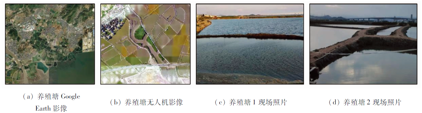
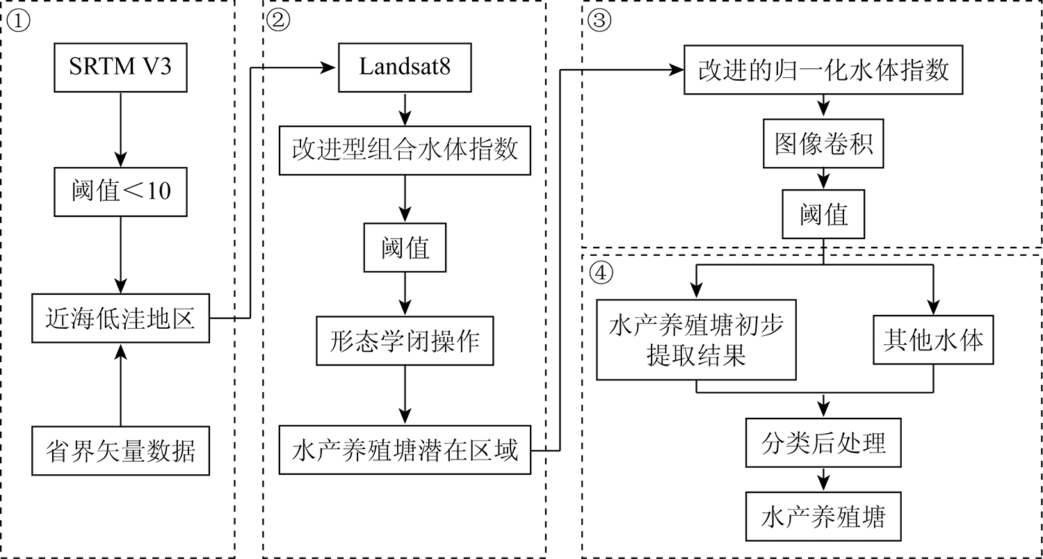
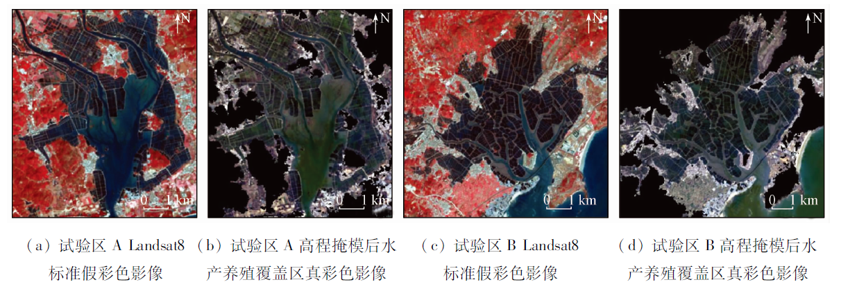
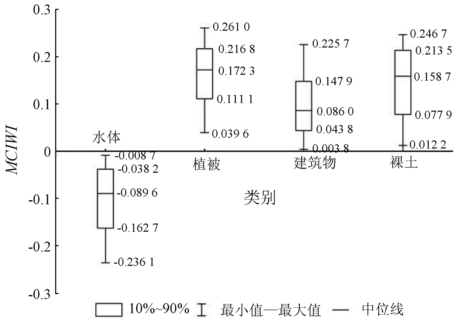
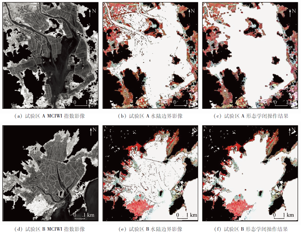
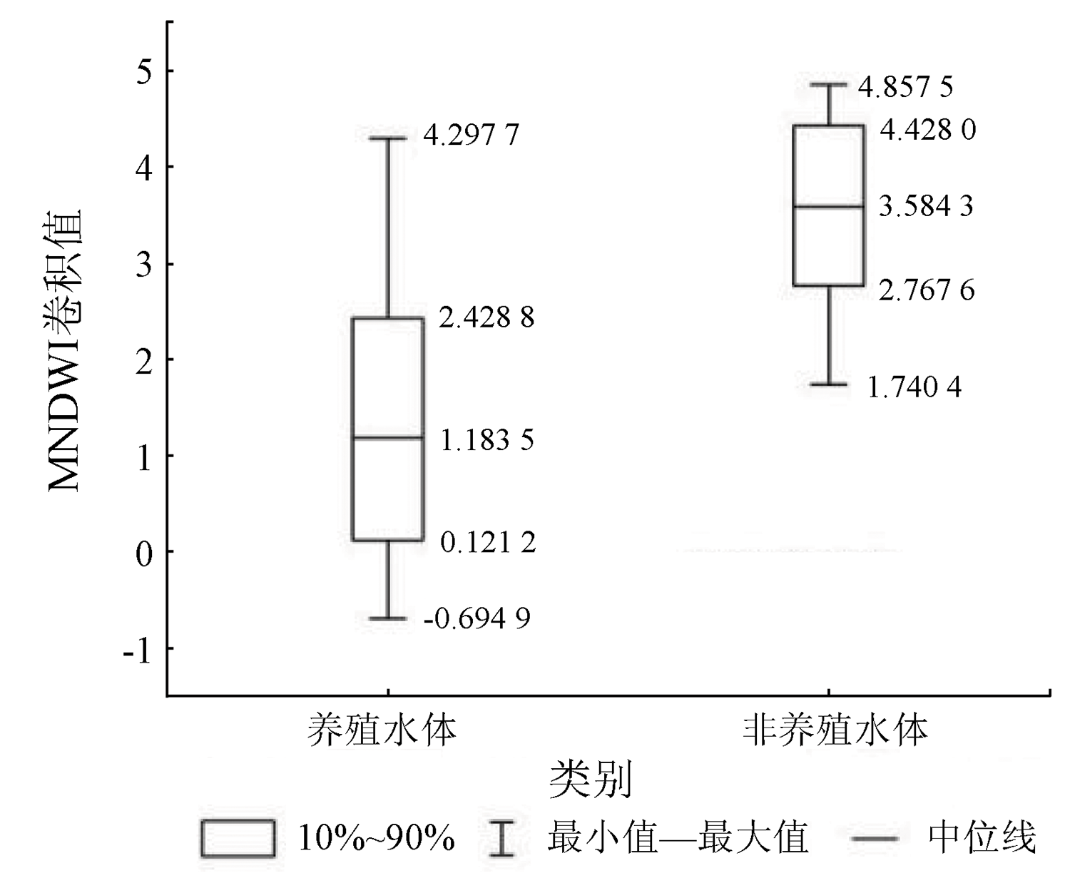
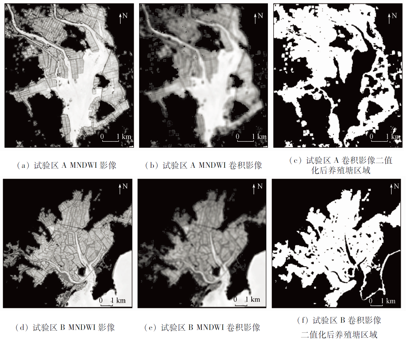
Abstract To control the negative effects of the disorderly development of aquaculture ponds and promote the further development of the aquaculture industry, the top priority is to realize rapid and accurate identification and extraction of information on aquaculture ponds. Aquaculture ponds are special net-like water bodies divided by complex roads and dikes. Simple spectral features or spatial texture features are not enough for accurate information extraction. Moreover, the mixed feature rule set gets more demanding on computer performance. Therefore, based on the Landsat image sequence and the Google Earth Engine (GEE) platform, this study proposed an automatic extraction method for coastal aquaculture ponds, which combined the image spectral information, spatial features, and morphological operation. In this method, dual characteristic water spectral indices, that is, the modified combined index for water identification (MCIWI) and the modified normalized difference water index (MNDWI), were employed to highlight the grid characteristics of large water bodies and aquaculture ponds. Then, the low-frequency filtering spatial convolution operation was used to stretch the differences between aquaculture and non-aquaculture water bodies. Finally, the information on aquaculture pond areas as a whole was identified and extracted accurately and quickly. The results are as follows. ① This method has overall precision of 93% and a Kappa coefficient of 0.86. According to the test process verification of typical area superposition comparison, the overlapping proportions between the extraction results and the actual results were all more than 90%, averaging 92.5%, reflecting the high precision and reliability of this extraction method. ② In 2020, the coastal aquaculture ponds in Fujian Province had a total area of 511.73 km2and were mainly distributed in Zhangzhou, Fuzhou, and Ningde cities. ③ The kernel density analysis suggested that Zhangzhou had a high concentration of aquaculture ponds and thus had high pressure in the management of aquaculture ponds. This method can realize automatic information extraction of coastal aquaculture ponds. Thus, it is of great significance to promote the orderly management and scientific development of fishery aquaculture.
|
| Keywords
aquaculture pond area
threshold segmentation
spatial convolution
GEE platform
|
|
|
|
Issue Date: 27 December 2022
|
|
|
| [1] |
Barange M. FAO yearbook:Fishery and aquaculture statistics 2018[R]. Roma: Food and Agriculture Organization of the United Nations(FAO), 2020.
|
| [2] |
吴荔生, 杨圣云. 试论养殖水域生态系统结构优化与管理[J]. 海洋科学, 2002(7):15-17.
|
| [2] |
Wu L S, Yang S Y. Study on the structure optimization and management of aquaculture water ecosystem[J]. Marine Science, 2002(7):15-17.
|
| [3] |
王大海. 海水养殖业发展规模经济及规模效率研究[D]. 青岛: 中国海洋大学, 2014.
|
| [3] |
Wang D H. Study on scale economy and scale efficiency of mariculture[D]. Qingdao: Ocean University of China, 2014.
|
| [4] |
李树国. 内陆水产养殖的水域污染及其防治对策[J]. 水产科学, 2005, 24(3):34-35.
|
| [4] |
Li S G. Water pollution in inland aquaculture and its control measures[J]. Journal of Fishery Sciences, 2005, 24(3):34-35.
|
| [5] |
王蒙蒙, 李国庆, 刘逸洁, 等. 近20年来山东半岛东部海水养殖水面的动态变化[J]. 应用海洋学学报, 2017, 36(3):319-326.
|
| [5] |
Wang M M, Li G Q, Liu Y J, et al. Dynamic changes of mariculture surface in eastern Shandong Peninsula during the past 20 years[J]. Journal of Applied Oceanography, 2017, 36(3):319-326.
|
| [6] |
时燕, 苏涛, 陆莉蓉. 长荡湖围网养殖区长时序时空演变遥感监测[J]. 环境监控与预警, 2021, 13(3):8-12.
|
| [6] |
Shi Y, Su T, Lu L R. Remote sensing monitoring of temporal and spatial evolution of seine farming area in Changdang Lake[J]. Environmental Monitoring and Warning, 2021, 13(3):8-12.
|
| [7] |
曹利, 顾文俊, 李小恕, 等. 基于WorldView数据的浙江省铁港牡蛎养殖分布遥感调查[J]. 渔业信息与战略, 2016, 31(4):286-292.
|
| [7] |
Cao L, Gu W J, Li X S, et al. Remote sensing investigation of oyster culture distribution in Tiegang,Zhejiang Province based on WorldView data[J]. Fisheries Information and Strategy, 2016, 31(4):286-292.
|
| [8] |
Chen L, Ren C, Zhang B, et al. Spatiotemporal dynamics of coastal wetlands and reclamation in the Yangtze estuary during past 50 years(1960s—2015)[J]. Chinese Geographical Science, 2018, 28(3):386-399.
doi: 10.1007/s11769-017-0925-3
url: https://doi.org/10.1007/s11769-017-0925-3
|
| [9] |
Zhou M, Wu M, Zhang G, et al. Analysis of coastal zone data of northern Yantai collected by remote sensing from 1990 to 2018[J]. Applied Sciences, 2019, 9(20):4466.
doi: 10.3390/app9204466
url: https://www.mdpi.com/2076-3417/9/20/4466
|
| [10] |
Xu M, Cui B, Lan S, et al. Exploring dynamic change of the tidal flat aquaculture area in the Shandong Peninsula (China) using multitemporal Landsat imagery(1990—2015)[J]. Journal of Coastal Research, 2020, 99:197-202.
doi: 10.2112/SI99-028.1
url: https://bioone.org/journals/journal-of-coastal-research/volume-99/issue-sp1/SI99-028.1/Exploring-Dynamic-Change-of-the-Tidal-Flat-Aquaculture-Area-in/10.2112/SI99-028.1.full
|
| [11] |
邵亚婷, 卢霞, 叶慧, 等. 滨海湿地土地覆盖面向对象分类及变化监测[J]. 海洋科学, 2020, 44(1):52-66.
|
| [11] |
Shao Y T, Lu X, Ye H, et al. Object-oriented classification and monitoring of land cover change in coastal wetland[J]. Marine Science, 2020, 44(1):52-66.
|
| [12] |
蒙静, 华璀, 张建兵, 等. 1995年—2015年广西海岸带养殖用地的时空分布[J]. 广西科学, 2017, 24(2):135-143.
|
| [12] |
Meng J, Hua C, Zhang J B, et al. Spatial and temporal distribution of aquaculture land in Guangxi coastal zone from 1995 to 2015[J]. Guangxi Science, 2017, 24(2):135-143.
|
| [13] |
李缨, 张翠芬, 帅爽, 等. 威海市近海水产养殖信息提取方法研究[J]. 湿地科学, 2017, 15(5):651-656.
|
| [13] |
Li Y, Zhang C F, Shuai S, et al. Research on extraction method of offshore aquaculture information in Weihai City[J]. Wetland Science, 2017, 15(5):651-656.
|
| [14] |
Sun N, Zhu W, Cheng Q. GF-1 and Landsat observed a 40-year wetland spatiotemporal variation and its coupled environmental factors in Yangtze River estuary[J]. Estuarine,Coastal and Shelf Science, 2018, 207:30-39.
doi: 10.1016/j.ecss.2018.03.022
url: https://linkinghub.elsevier.com/retrieve/pii/S0272771417304729
|
| [15] |
王宁, 程家骅, 张寒野, 等. 水产养殖水体遥感动态监测及其应用[J]. 中国水产科学, 2019, 26(5):893-903.
|
| [15] |
Wang N, Cheng J H, Zhang H Y, et al. Remote sensing dynamic monitoring of aquaculture water and its application[J]. Journal of Fishery Sciences of China, 2019, 26(5):893-903.
|
| [16] |
程博, 刘岳明, 刘旭楠, 等. 基于多源特征融合的高分辨率遥感图像近海养殖区提取方法研究[J]. 遥感技术与应用, 2018, 33(2):296-304.
|
| [16] |
Cheng B, Liu Y M, Liu X N, et al. Research on extraction method of offshore aquaculture area based on multi-source feature fusion of high-resolution remote sensing image[J]. Remote Sensing Technology and Application, 2018, 33(2):296-304.
|
| [17] |
黄帅, 宋开宏, 罗菊花, 等. 基于梯度变换的浅水湖泊围网区遥感提取算法[J]. 湖泊科学, 2017, 29(2):490-497.
|
| [17] |
Huang S, Song K H, Luo J H, et al. Remote sensing extraction algorithm for shallow lake seine area based on gradient transformation[J]. Journal of Lake Sciences, 2017, 29(2):490-497.
doi: 10.18307/2017.0225
url: http://www.jlakes.org/ch/reader/view_abstract.aspx?doi=10.18307/2017.0225
|
| [18] |
孙裕钰, 应警亮, 王梅, 等. 面向对象的围海养殖用海信息分类提取与动态监测研究[J]. 海洋信息, 2016(2):6-11.
|
| [18] |
Sun Y Y, Ying J L, Wang M, et al. Study on classification extraction and dynamic monitoring of marine information for aquaculture[J]. Marine Information, 2016(2):6-11.
|
| [19] |
黄森文, 韦春竹. 广东省沿海城市人工水产养殖基地变化——基于2015—2019年Sentinel-1数据的实证研究[J]. 热带地理, 2021, 41(3):622-634.
doi: 10.13284/j.cnki.rddl.003348
|
| [19] |
Huang S W, Wei C Z. Changes of artificial aquaculture bases in coastal cities of Guangdong Province:An empirical study based on Sentinel-1 data from 2015 to 2019[J]. Tropical Geography, 2021, 41(3):622-634.
|
| [20] |
裴亮, 王金鑫, 屈慧慧, 等. 基于ONDPI的海岸养殖池塘遥感影像提取研究[J]. 海洋测绘, 2020, 40(5):40-44.
|
| [20] |
Pei L, Wang J X, Qu H H, et al. Remote sensing image extraction of coastal aquaculture ponds based on ONDPI[J]. Marine Surveying and Mapping, 2020, 40(5):40-44.
|
| [21] |
袁鑫, 张丽, 宋茜茜, 等. 海南岛海水池塘养殖遥感监测与时空变化分析[J]. 海洋学研究, 2020, 38(1):59-67.
doi: 10.3969/j.issn.1001-909X.2020.01.007
|
| [21] |
Yuan X, Zhang L, Song Q Q, et al. Remote sensing monitoring and spatial-temporal analysis of seawater pond aquaculture in Hainan Island[J]. Journal of Oceanographic Research, 2020, 38(1):59-67.
|
| [22] |
王芳, 夏丽华, 陈智斌, 等. 基于关联规则面向对象的海岸带海水养殖模式遥感识别[J]. 农业工程学报, 2018, 34(12):210-217.
|
| [22] |
Wang F, Xia L H, Chen Z B, et al. Object-oriented mariculture pattern recognition based on association rules[J]. Transactions of the Chinese Society of Agricultural Engineering, 2018, 34(12):210-217.
|
| [23] |
Fu Y, Deng J, Ye Z, et al. Coastal aquaculture mapping from very high spatial resolution imagery by combining object-based neighbor features[J]. Sustainability, 2019, 11(3):637.
doi: 10.3390/su11030637
url: http://www.mdpi.com/2071-1050/11/3/637
|
| [24] |
Gorelick N, Hancher M, Dixon M, et al. Google Earth Engine:Planetary-scale geospatial analysis for everyone[J]. Remote Sensing of Environment, 2017, 202:18-27.
doi: 10.1016/j.rse.2017.06.031
url: https://linkinghub.elsevier.com/retrieve/pii/S0034425717302900
|
| [25] |
杨平, 谭立山, 黄佳芳, 等. 初冬时期闽江河口区养殖塘排水后的CH_4和N_2O通量日变化特征[J]. 环境科学, 2018, 39(1):300-309.
|
| [25] |
Yang P, Tan L S, Huang J F, et al. Diurnal variation of CH_4 and N_2O fluxes after drainage from aquaculture ponds in the Minjiang River estuary during early winter[J]. Environmental Science, 2018, 39(1):300-309.
|
| [26] |
Ren C, Wang Z, Zhang Y, et al. Rapid expansion of coastal aquaculture ponds in China from Landsat observations during 1984—2016[J]. International Journal of Applied Earth Observation Geoinformation, 2019, 82:101902.
doi: 10.1016/j.jag.2019.101902
url: https://linkinghub.elsevier.com/retrieve/pii/S0303243419304295
|
| [27] |
Duan Y, Li X, Zhang L, et al. Detecting spatiotemporal changes of large-scale aquaculture ponds regions over 1988—2018 in Jiangsu Province,China using Google Earth Engine[J]. Ocean and Coastal Management, 2020, 188:105144.
doi: 10.1016/j.ocecoaman.2020.105144
url: https://linkinghub.elsevier.com/retrieve/pii/S0964569120300545
|
| [28] |
Duan Y, Li X, Zhang L, et al. Mapping national-scale aquaculture ponds based on the Google Earth Engine in the Chinese coastal zone[J]. Aquaculture, 2020, 520:734666.
doi: 10.1016/j.aquaculture.2019.734666
url: https://linkinghub.elsevier.com/retrieve/pii/S0044848619310701
|
| [29] |
杨宝钢, 陈昉, 罗孳孳. 基于MODIS的改进型组合水体指数(MCIWI)提取复杂水体信息的试验[J]. 西南大学学报(自然科学版), 2011, 33(1):112-119.
|
| [29] |
Yang B G, Chen F, Luo Z Z. Extraction of complex water information based on MODIS improved combined water index (MCIWI)[J]. Journal of Southwest University (Science and Technology Edition), 2011, 33(1):112-119.
|
| [30] |
陈冬岚, 刘京南, 余玲玲. 几种图像分割阈值选取方法的比较与研究[J]. 机械制造与自动化, 2003(1):77-80.
|
| [30] |
Chen D L, Liu J N, Yu L L. Comparison and research on several methods of image segmentation threshold selection[J]. Machine Building and Automation, 2003(1):77-80.
|
| [31] |
李宝芸, 范玉刚, 高阳. 基于OTSU和Canny算子的红外图像特征提取[J]. 陕西理工大学学报(自然科学版), 2019, 35(6):33-40.
|
| [31] |
Li B Y, Fan Y G, Gao Y. Infrared image feature extraction based on OTSU and Canny operator[J]. Journal of Shaanxi University of Technology (Natural Science Edition), 2019, 35(6):33-40.
|
| [32] |
Zhang G, Wu M, Wei J, et al. Adaptive threshold model in Google Earth Engine:A case study of ulva prolifera extraction in the South Yellow Sea,China[J]. Remote Sensing, 2021, 13(16):3240.
doi: 10.3390/rs13163240
url: https://www.mdpi.com/2072-4292/13/16/3240
|
| [33] |
Donchyts G, Schellekens J, Winsemius H, et al. A 30 m resolution surface water mask including estimation of positional and thematic differences using Landsat8,SRTM and openstreetmap:A case study in the Murray-Darling basin,Australia[J]. Remote Sensing, 2016, 8(5):386.
doi: 10.3390/rs8050386
url: http://www.mdpi.com/2072-4292/8/5/386
|
| [34] |
徐涵秋. 利用改进的归一化差异水体指数(MNDWI)提取水体信息的研究[J]. 遥感学报, 2005, 9(5):589-595.
|
| [34] |
Xu H Q. Study on water information extraction using improved normalized difference water index (MNDWI)[J]. Journal of Remote Sensing, 2005, 9(5):589-595.
|
|
Viewed |
|
|
|
Full text
|
|
|
|
|
Abstract
|
|
|
|
|
Cited |
|
|
|
|
| |
Shared |
|
|
|
|
| |
Discussed |
|
|
|
|
 2022,
Vol. 34
2022,
Vol. 34