|
|
 |
|

|
|
|
Spatial-spectral joint classification of airborne multispectral LiDAR point clouds based on the multivariate GMM |
WANG Liying1( ), MA Xuwei2,3,4, YOU Ze1, WANG Shichao1, CAMARA Mahamadou1 ), MA Xuwei2,3,4, YOU Ze1, WANG Shichao1, CAMARA Mahamadou1 |
1. School of Geomatics, Liaoning Technical University, Fuxin 123000, China
2. CGTEG China Coal Research Institute, Beijing 100013, China
3. Engineering Research Center for Technology Equipment of Emergency Refuge in Coal Mine, Beijing 100013, China
4. Beijing Coal Mine Safety Engineering Technology Research Center, Beijing 100013, China |
|
|
|
|
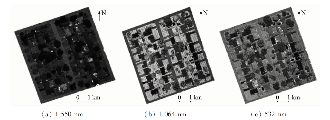
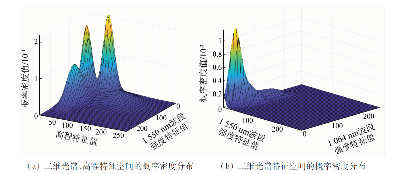
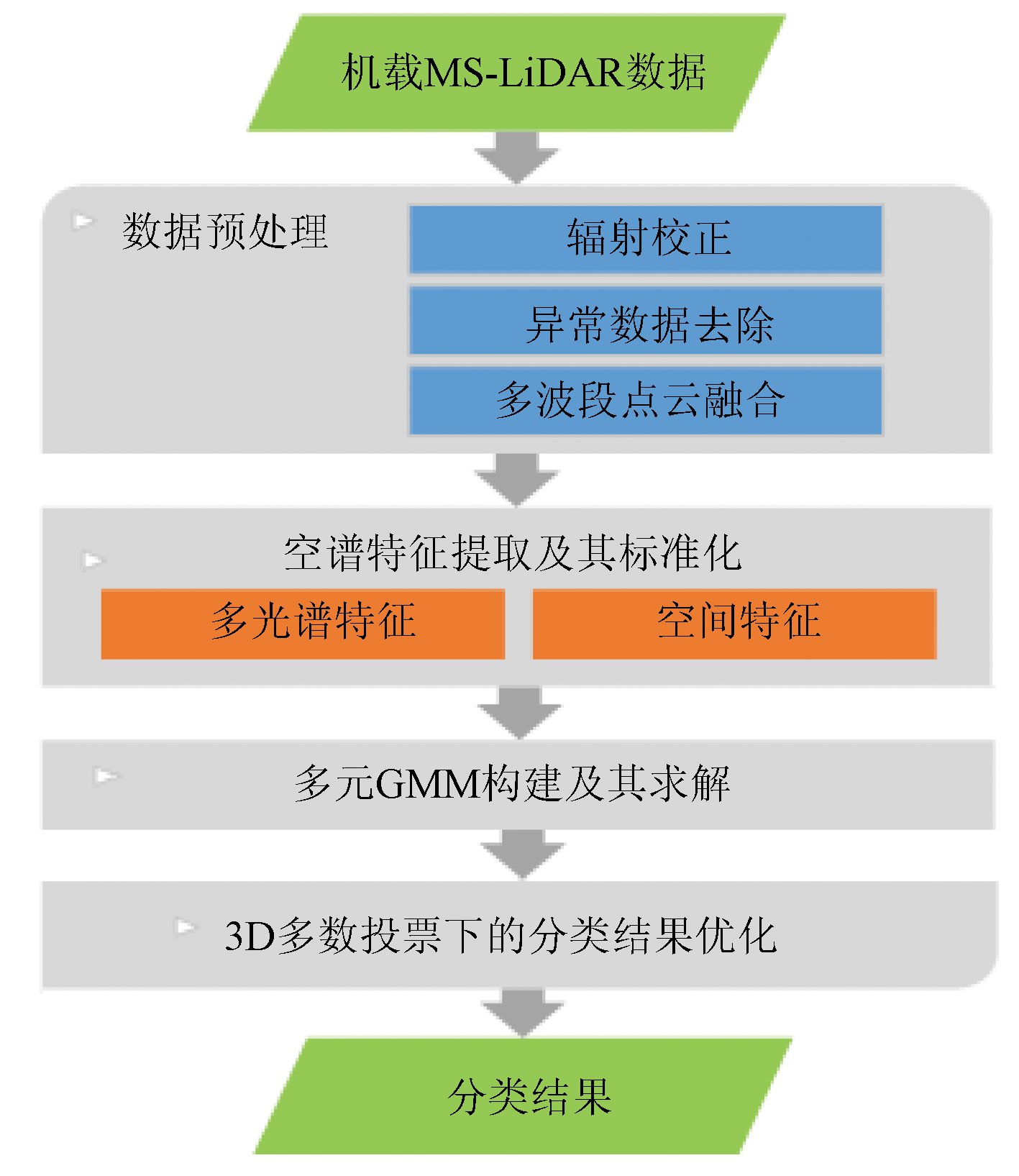
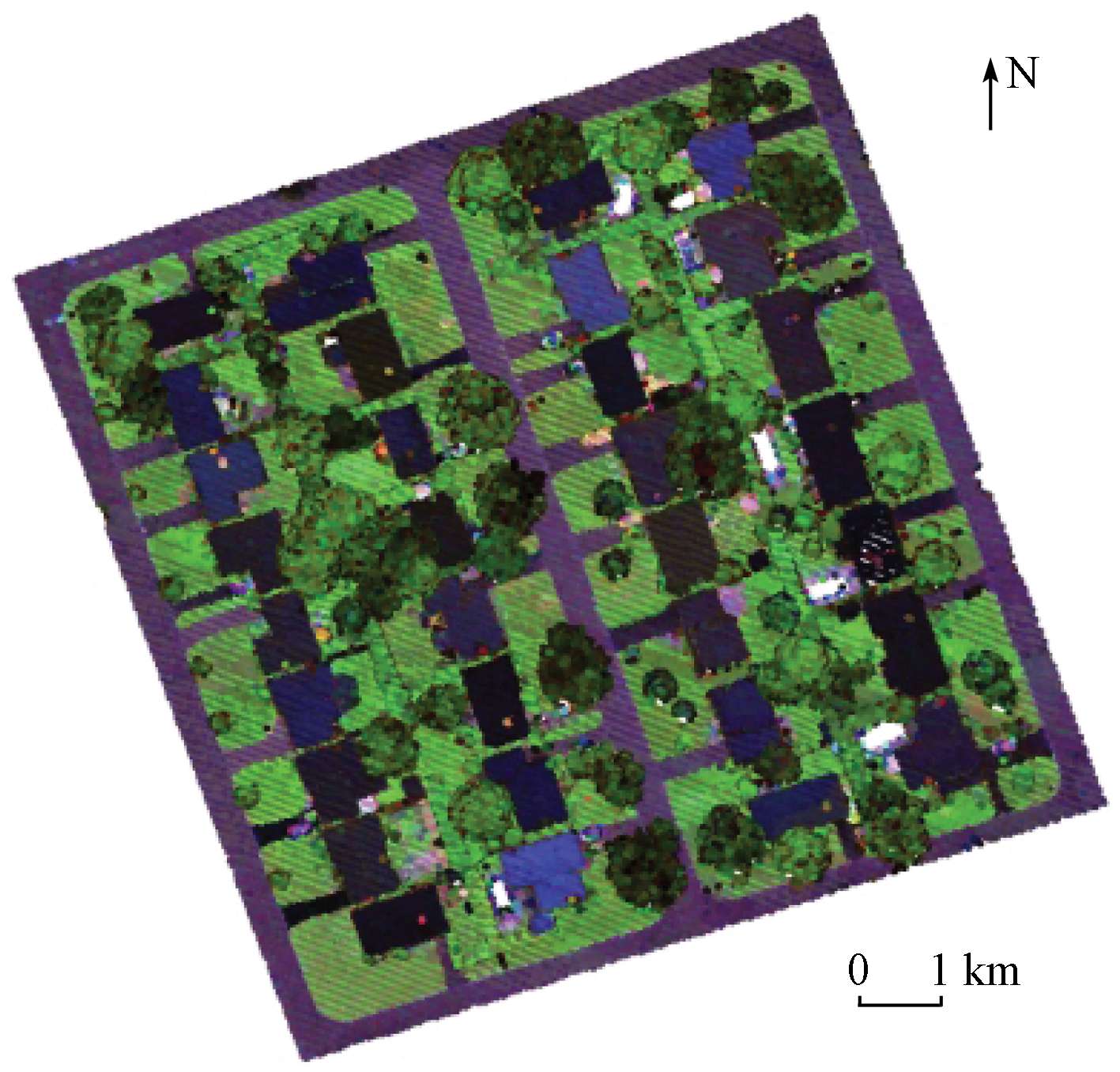
Abstract Conventional land cover classification methods based on airborne multispectral light detection and ranging (MS-LiDAR) data have insufficient capability for the cooperative utilization of spatial-spectral information or too high dimensions of features in the joint utilization of various features. This study proposed a spatial-spectral joint segmentation algorithm for airborne MS-LiDAR point clouds based on the multivariate Gaussian mixture model (GMM). First, radiometric correction, anomaly removal, and data fusion were performed for the original multi-band independent point clouds, forming multispectral point clouds that presented spatial locations and their multi-band spectral information. Then, spatial-spectral feature vectors were constructed using the extracted multispectral and elevation features of laser points. Meanwhile, the unit and scale differences among different types of features were eliminated through feature normalization and discretization. Subsequently, a GMM was built to fit the multimodal distribution of objects in the spatial-spectral feature space. Accordingly, the response levels of laser points to various objects were obtained, and the classification of various objects was determined according to the principle of maximum responsiveness. Finally, a 3D majority voting method was designed to optimize the segmentation results. The effectiveness and feasibility of the proposed algorithm were verified through experiments based on surveyed Optech Titan MS-LiDAR data. The experimental results show that the multivariate GMM combined with multi-band intensity features and elevation features yielded an overall segmentation accuracy of 93.57% and a Kappa coefficient of 0.912. The results also indicate that the high-accuracy segmentation of MS-LiDAR point clouds can be achieved by only combining four-dimensional features. This study provides a new approach for comprehensively utilizing the multispectral and spatial information in MS-LiDAR data.
|
| Keywords
multispectral light detection and ranging
point cloud segmentation
multivariate Gaussian mixture model
multimodal distribution
majority voting method
spatial-spectral joint feature
|
|
|
|
Issue Date: 19 September 2023
|
|
|
| [1] |
Zhou W. An object-based approach for urban land cover classification:Integrating LiDAR height and intensity data[J]. IEEE Geoscience and Remote Sensing Letters, 2013, 10(4):928-931.
doi: 10.1109/LGRS.8859
url: https://ieeexplore.ieee.org/xpl/RecentIssue.jsp?punumber=8859
|
| [2] |
张继贤, 林祥国, 梁欣廉. 点云信息提取研究进展和展望[J]. 测绘学报, 2017, 46(10):1460-1469.
doi: 10.11947/j.AGCS.2017.20170345
|
| [2] |
Zhang J X, Lin X G, Liang X L. Advances and prospects of information extraction from point clouds[J]. Acta Geodaetica et Cartographica Sinica, 2017, 46(10):1460-1469.
doi: 10.11947/j.AGCS.2017.20170345
|
| [3] |
Morsy S, Shaker A, El-Rabbany A. Multispectral LiDAR data for land cover classification of urban areas[J]. Sensors, 2017, 17(5):958.
doi: 10.3390/s17050958
url: https://www.mdpi.com/1424-8220/17/5/958
|
| [4] |
Wichmann V, Bremer M, Lindenberger J, et al. Evaluating the potential of multispectral airborne LiDAR for topographic mapping and land cover classification[J]. ISPRS Annals of Photogrammetry,Remote Sensing and Spatial Information Sciences, 2015, 2:113-119.
|
| [5] |
Zulfiquar K. Performance analysis of multispectial LiDAR in land cover classification[D]. Toronto: Ryerson University, 2017.
|
| [6] |
Morsy S, Shaker A, El-Rabbany Y A, et al. Airborne multi-spectral LiDAR data for land-cover classification and land/water map-ping using different spectral indexes[J]. ISPRS Annals of Photogrammetry,Remote Sensing and Spatial Information Sciences, 2016, III-3:217-224.
|
| [7] |
Chen B, Shi S, Gong W, et al. Multispectral LiDAR point cloud classification:A two-step approach[J]. Remote Sensing, 2017, 9 (4):373.
doi: 10.3390/rs9040373
url: http://www.mdpi.com/2072-4292/9/4/373
|
| [8] |
Fernandez-Diaz J, Carter W, Glennie C, et al. Capability assessment and performance metrics for the Titan multispectral mapping LiDAR[J]. Remote Sensing, 2016, 8(11):936.
doi: 10.3390/rs8110936
url: http://www.mdpi.com/2072-4292/8/11/936
|
| [9] |
潘锁艳, 管海燕. 机载多光谱LiDAR数据的地物分类方法[J]. 测绘学报, 2018, 47(2):198-207.
doi: 10.11947/j.AGCS.2018.20170512
|
| [9] |
Pan S Y, Guan H Y. Object classification using airborne multispectral LiDAR data[J]. Acta Geodaetica et Cartographica Sinica, 2018, 47(2):198-207.
doi: 10.11947/j.AGCS.2018.20170512
|
| [10] |
Huo L Z, Silva C A, Klauberg C, et al. Supervised spatial classification of multispectral LiDAR data in urban areas[J]. PLoS One, 2018, 13(10):e0206185.
doi: 10.1371/journal.pone.0206185
url: https://dx.plos.org/10.1371/journal.pone.0206185
|
| [11] |
Wang Y, Gu Y. Multispectral LiADR data fusion via multiple kernel learning for remote sensing classification[C]// 2018 9th Workshop on Hyperspectral Image and Signal Processing:Evolution in Remote Sensing (WHISPERS).IEEE, 2018:1-6.
|
| [12] |
Teo T A, Wu H M. Analysis of land cover classification using multi-wavelength LiDAR system[J]. Applied Sciences, 2017, 7(7):663.
doi: 10.3390/app7070663
url: http://www.mdpi.com/2076-3417/7/7/663
|
| [13] |
Sun J, Shi S, Chen B, et al. Combined application of 3D spectral features from multispectral LiDAR for classification[C]// IEEE International Geoscience and Remote Sensing Symposium.IEEE, 2017:5264-5267.
|
| [14] |
Wang Q, Gu Y. A Discriminative tensor representation model for feature extraction and classification of multispectral LiDAR data[J]. IEEE Transactions on Geoscience and Remote Sensing, 2019, 58(3):1568-1586.
doi: 10.1109/TGRS.36
url: https://ieeexplore.ieee.org/xpl/RecentIssue.jsp?punumber=36
|
| [15] |
Ahokas E, Hyyppä J, Yu X, et al. Towards automatic single-sensor mapping by multispectral airborne laser scanning[J]. International Archives of the Photogrammetry,Remote Sensing and Spatial Information Sciences, 2016, XLI-B3:155-162.
|
| [16] |
袁鹏飞, 黄荣刚, 胡平波, 等. 基于多光谱LiDAR数据的道路中心线提取[J]. 地球信息科学学报, 2018, 20(4):452-461.
doi: 10.12082/dqxxkx.2018.170634
|
| [16] |
Yuan P F, Huang R G, Hu P B, et al. Road axis extraction method based on multi-spectral LiDAR data[J]. Journal of Geo-Information Science, 2018, 20(4):452-461.
|
| [17] |
曹爽, 潘锁艳, 管海燕. 机载多光谱LiDAR的随机森林地物分类[J]. 测绘通报, 2019(11):79-84.
doi: 10.13474/j.cnki.11-2246.2019.0356
|
| [17] |
Cao S, Pan S Y, Guan H Y. Random forest-based land-use classification using multispectral LiDAR data[J]. Bulletin of Surveying and Mapping, 2019(11):79-84.
doi: 10.13474/j.cnki.11-2246.2019.0356
|
| [18] |
Shaker A, Yan W Y, Larocque P E. Automatic land-water classification using multispectral airborne LiDAR data for near-shore and river environments[J]. ISPRS Journal of Photogrammetry and Remote Sensing, 2019, 152:94-108.
doi: 10.1016/j.isprsjprs.2019.04.005
|
| [19] |
Bakuła K, Kupidura P, Jełowicki Ł. Testing of land cover classification from multispectral airborne laser scanning data[J]. International Archives of the Photogrammetry,Remote Sensing and Spatial Information Sciences, 2016, XLI-B7:161-169.
|
| [20] |
Miller C I, Thomas J J, Kim A M, et al. Application of image classification techniques to multispectral LiDAR point cloud data[C]// Laser Radar Technology and Applications XXI.International Society for Optics and Photonics, 2016, 9832:98320X.
|
| [21] |
Zou X L, Zhao G H, Li J, et al. 3D land cover classification based on multispectral LiDAR point clouds[J]. International Archives of the Photogrammetry,Remote Sensing and Spatial Information Sciences, 2016, XLI-B1:741-747.
|
| [22] |
Unnikrishnan A, Sowmya P S K. Deep AlexNet with reduced number of trainable parameters for satellite image classification[J]. Procedia Computer Science, 2018, 143:931-938.
doi: 10.1016/j.procs.2018.10.342
url: https://linkinghub.elsevier.com/retrieve/pii/S1877050918320386
|
| [23] |
Zhang C, Sargent I, Pan X, et al. An object-based convolutional neural network (OCNN) for urban land use classification[J]. Remote Sensing of Environment, 2018, 261:57-70.
|
| [24] |
Jiang Y, Li Y, Zhang H. Hyperspectral image classification based on 3-D separable ResNet and transfer learning[J]. IEEE Geoscience and Remote Sensing Letters, 2019, 16(12):1949-1953.
doi: 10.1109/LGRS.8859
url: https://ieeexplore.ieee.org/xpl/RecentIssue.jsp?punumber=8859
|
| [25] |
Pan S, Guan H, Chen Y, et al. Land-cover classification of multispectral LiDAR data using CNN with optimized hyper-parameters[J]. ISPRS Journal of Photogrammetry and Remote Sensing, 2020, 166:241-254.
doi: 10.1016/j.isprsjprs.2020.05.022
url: https://linkinghub.elsevier.com/retrieve/pii/S0924271620301489
|
| [26] |
Pan S, Guan H, Yu Y, et al. A comparative land-cover classification feature study of learning algorithms:DBM,PCA,and RF using multispectral LiDAR data[J]. IEEE Journal of Selected Topics in Applied Earth Observations and Remote Sensing, 2019, 12(4):1314-1326.
doi: 10.1109/JSTARS.4609443
url: https://ieeexplore.ieee.org/xpl/RecentIssue.jsp?punumber=4609443
|
| [27] |
Yu Y, Liu C, Guan H, et al. Land cover classification of multispectral LiDAR data with an efficient self-attention capsule network[J]. IEEE Geoscience and Remote Sensing Letters, 2021, 19:1-5.
|
| [28] |
Yu Y T, Guan H Y, Li D L, et al. A hybrid capsule network for land cover classification using multispectral LiDAR data[J]. IEEE Geoscience and Remote Sensing Letters, 2020, 17(7):1263-1267.
doi: 10.1109/LGRS.8859
url: https://ieeexplore.ieee.org/xpl/RecentIssue.jsp?punumber=8859
|
| [29] |
Wang Q, Zhang X, Gu Y. Spatial-spectral smooth graph convolutional network for multispectral point cloud classification[C]// IEEE International Geoscience and Remote Sensing Symposium,IEEE, 2020:1062-1065.
|
| [30] |
Li D, Shen X, Yu Y, et al. Building extraction from airborne multi-spectral LiDAR point clouds based on graph geometric moments convolutional neural networks[J]. Remote Sensing, 2020, 12(19):3186.
doi: 10.3390/rs12193186
url: https://www.mdpi.com/2072-4292/12/19/3186
|
| [31] |
Yan W Y, Shaker A. Radiometric correction and normalization of airborne LiDAR intensity data for improving land-cover classification[J]. IEEE Transactions on Geoscience and Remote Sensing, 2012, 67:35-44.
|
| [32] |
Gauvain J L, Lee C H. Maximum a posteriori estimation for multivariate Gaussian mixture observations of Markov chains[J]. IEEE Transactions on Speech and Audio Processing, 1994, 2(2):291-298.
doi: 10.1109/89.279278
url: http://ieeexplore.ieee.org/document/279278/
|
| [33] |
Day N E. Estimating the components of a mixture of normal distributions[J]. Biometrika, 1969(3):463-474.
|
|
Viewed |
|
|
|
Full text
|
|
|
|
|
Abstract
|
|
|
|
|
Cited |
|
|
|
|
| |
Shared |
|
|
|
|
| |
Discussed |
|
|
|
|
 2023,
Vol. 35
2023,
Vol. 35