|
|
 |
|

|
|
|
Multi-level building change detection based on the DSM and DOM generated from UAV images |
CHAI Jiaxing1( ), ZHANG Yunsheng1,2,3(), YANG Zhen1, CHEN Siyang1, LI Haifeng1 ), ZHANG Yunsheng1,2,3(), YANG Zhen1, CHEN Siyang1, LI Haifeng1 |
1. School of Geosciences and Info-physics, Central South University, Changsha 410012, China
2. Hunan Provincial Key Laboratory of Key Technology on Hydropower Development, Power China Zhongnan Engineering Co., Ltd., Changsha 410021, China
3. Key Laboratory of Ecological Environment Protection of Space Information Application of Henan, Zhengzhou 450046, China |
|
|
|
|
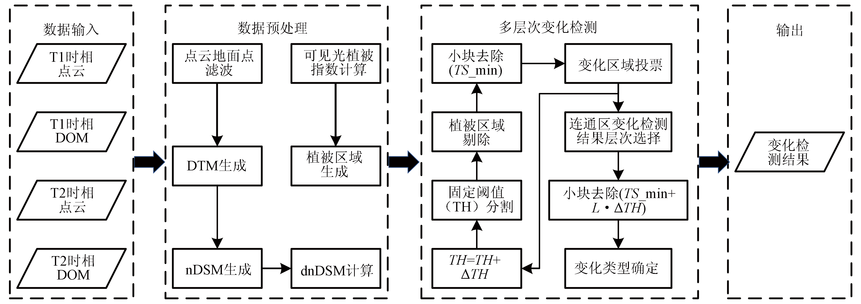
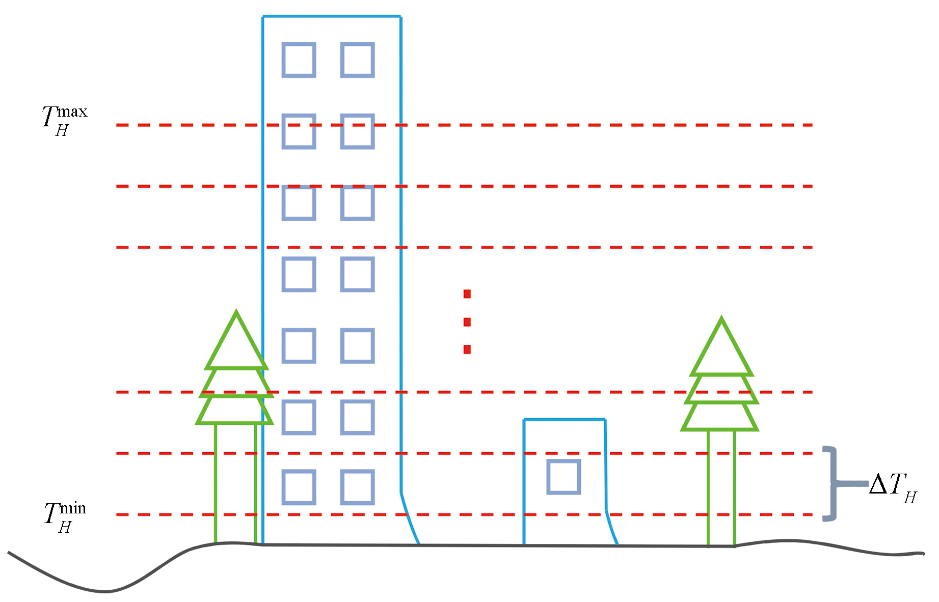
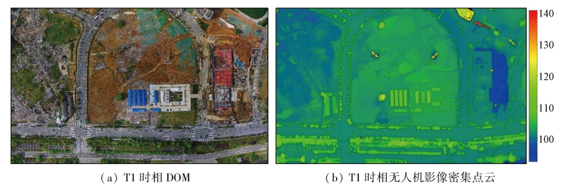
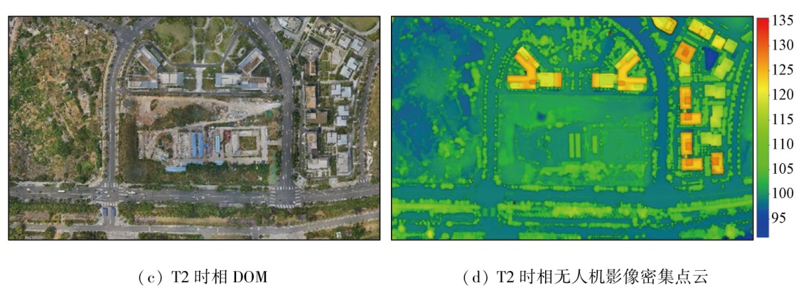
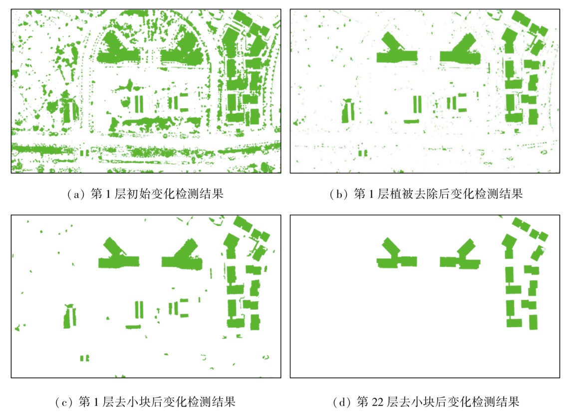
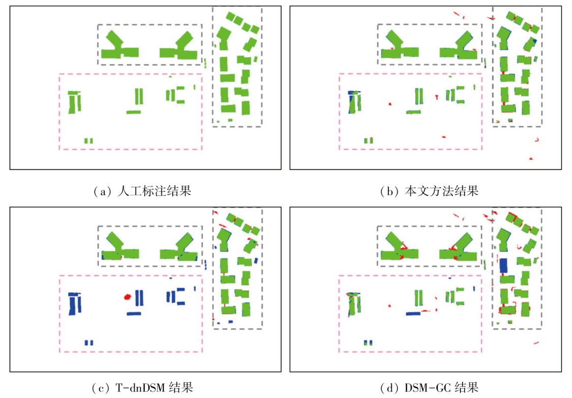
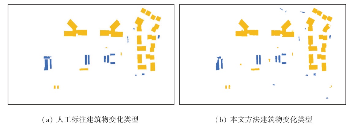
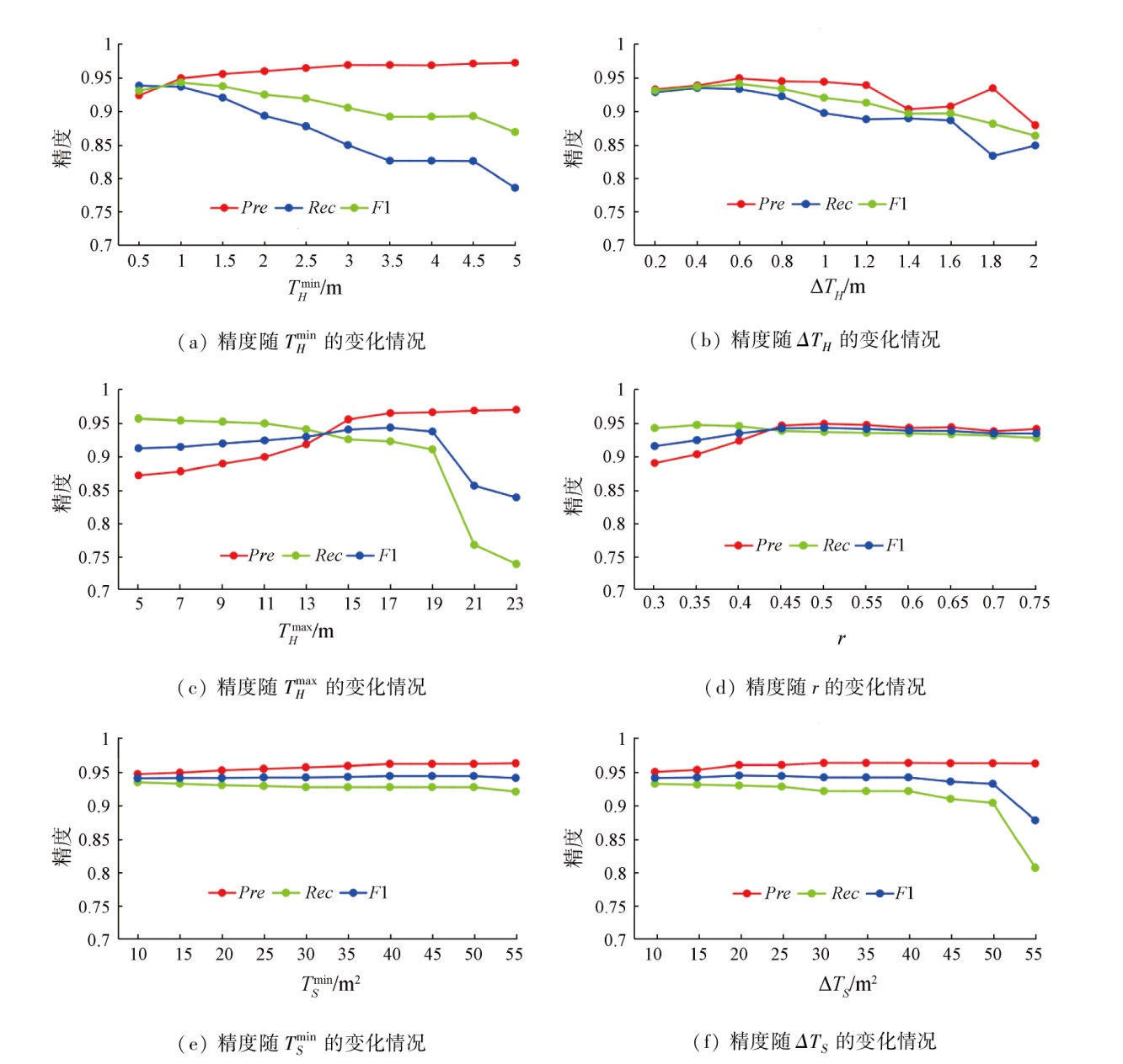
Abstract The continuous advancement of urbanization in China leads to frequently changing urban buildings. Hence, grasping the change information of urban buildings duly and accurately holds critical significance for urban management, investigation of unauthorized construction, and disaster assessment. This study proposed a multi-level building change detection method combined with the digital surface model (DSM) and digital orthophoto map (DOM) generated from unmanned aerial vehicle (UAV) images. The proposed method consists of four steps: ① The dense point cloud and DOM generated from UAV images were pre-processed to generate differential normalized DSM (dnDSM) and extract vegetation zones; ② Candidate change zones were extracted using multi-level height difference thresholds, with vegetation and smaller zones eliminated; ③ The connected component analysis was conducted for lower-level candidate change zones. For connected objects, their higher-level change detection results were used to eliminate false detection results in the lower level; ④ The quantitative relationship between positive and negative height difference values of change objects was statistically analyzed to determine the change types. As demonstrated by experimental results, the proposed method can retain the change information of low-rise buildings detected through the lower height difference thresholds while ensuring correct and complete change information of high-rise buildings.
|
| Keywords
building change detection
unmanned aerial vehicle image
digital surface model
digital orthophoto map
|
|
|
|
Issue Date: 14 June 2024
|
|
|
| [1] |
宁启蒙, 胡广云, 汤放华, 等. 科技创新与新型城镇化相关性的实证分析——以长株潭城市群为例[J]. 经济地理, 2022, 42(8):81-86.
doi: 10.15957/j.cnki.jjdl.2022.08.009
|
| [1] |
Ning Q M, Hu G Y, Tang F H, et al. Correlation between technology innovation and new-type urbanization: A case study of the Changsha-Zhuzhou-Xiangtan urban agglomeration[J]. Economic Geography, 2022, 42(8):81-86.
|
| [2] |
刘雪华, 孙大鹏. 政策工具视角下我国城镇化政策文本量化研究——基于2014—2020年的国家政策文本[J]. 吉林大学社会科学学报, 2022, 62(2):211-222,240.
|
| [2] |
Liu X H, Sun D P. Quantitative research on urbanization policy documents in China from the perspective of policy tools:Base on national policy documents from 2014 to 2020[J]. Jilin University Journal Social Sciences Edition, 2022, 62(2):211-222,240.
|
| [3] |
国家发展改革委印发《2022年新型城镇化和城乡融合发展重点任务》[J]. 小城镇建设, 2022, 40(4):117-119.
|
| [3] |
National development and reform commission issues “Key tasks of new urbanization and urban-rural integration development in 2022”[J]. Development of Small Cities and Towns, 2022, 40(4):117-119.
|
| [4] |
朱庆, 张利国, 丁雨淋, 等. 从实景三维建模到数字孪生建模[J]. 测绘学报, 2022, 51(6):1040-1049.
doi: 10.11947/j.AGCS.2022.20210640
|
| [4] |
Zhu Q, Zhang L G, Ding Y L, et al. From real 3D modeling to digital twin modeling[J]. Acta Geodaetica et Cartographica Sinica, 2022, 51(6):1040-1049.
doi: 10.11947/j.AGCS.2022.20210640
|
| [5] |
冯文卿, 眭海刚, 涂继辉, 等. 高分辨率遥感影像的随机森林变化检测方法[J]. 测绘学报, 2017, 46(11):1880-1890.
doi: 10.11947/j.AGCS.2017.20170074
|
| [5] |
Feng W Q, Sui H G, Tu J H, et al. Change detection method for high resolution remote sensing images using random forest[J]. Acta Geodaetica et Cartographica Sinica, 2017, 46(11):1880-1890.
doi: 10.11947/j.AGCS.2017.20170074
|
| [6] |
Qin R J, Tian J J, Reinartz P. 3D change detection-approaches and applications[J]. ISPRS Journal of Photogrammetry and Remote Sensing, 2016, 122:41-56.
|
| [7] |
Qin R J, Huang X, Gruen A, et al. Object-based 3D building change detection on multi-temporal stereo images[J]. IEEE Journal of Selected Topics in Applied Earth Observations and Remote Sensing, 2015, 8(5):2125-2137.
|
| [8] |
叶沅鑫, 孙苗苗, 王蒙蒙, 等. 结合邻域信息和结构特征的遥感影像变化检测[J]. 测绘学报, 2021, 50(10):1349-1357.
doi: 10.11947/j.AGCS.2021.20200130
|
| [8] |
Ye Y X, Sun M M, Wang M M, et al. Change detection of remote sensing images by combining neighborhood information and structural features[J]. Acta Geodaetica et Cartographica Sinica, 2021, 50(10):1349-1357.
doi: 10.11947/j.AGCS.2021.20200130
|
| [9] |
Du S J, Zhang Y S, Qin R J, et al. Building change detection using old aerial images and new LiDAR data[J]. Remote Sensing, 2016, 8(12):1030.
|
| [10] |
张祖勋, 姜慧伟, 庞世燕, 等. 多时相遥感影像的变化检测研究现状与展望[J]. 测绘学报, 2022, 51(7):1091-1107.
doi: 10.11947/j.AGCS.2022.20220070
|
| [10] |
Zhang Z X, Jiang H W, Pang S Y, et al. Review and prospect in change detection of multi-temporal remote sensing images[J]. Acta Geodaetica et Cartographica Sinica, 2022, 51(7):1091-1107.
doi: 10.11947/j.AGCS.2022.20220070
|
| [11] |
Murakami H, Nakagawa K, Hasegawa H, et al. Change detection of buildings using an airborne laser scanner[J]. ISPRS Journal of Photogrammetry and Remote Sensing, 1999, 54(2/3):148-152.
|
| [12] |
Tian J J, Chaabouni-Chouayakh H, Reinartz P, et al. Automatic 3D change detection based on optical satellite stereo imagery[J]. International Archives of the Photogrammetry,Remote Sensing and Spatial Information Sciences, 2010, 38(7B):586-591.
|
| [13] |
Chaabouni-Chouayakh H, Krauss T, d’Angelo P, et al. 3D change detection inside urban areas using different digital surface models[J]. International Archives of the Photogrammetry,Remote Sensing and Spatial Information Sciences, 2010, 38(3B):86-91.
|
| [14] |
Sasagawa A, Baltsavias E, Kocaman-Aksakal S, et al. Investigation on automatic change detection using pixel-changes and DSM-changes with ALOS-PRISM triplet images[J]. International Archives of the Photogrammetry,Remote Sensing and Spatial Information Sciences, 2013, 40(7/W2):213-217.
|
| [15] |
Pang S Y, Hu X Y, Wang Z Z, et al. Object-based analysis of airborne LiDAR data for building change detection[J]. Remote Sensing, 2014, 6(11):10733-10749.
|
| [16] |
彭代锋, 张永军, 熊小东. 结合LiDAR点云和航空影像的建筑物三维变化检测[J]. 武汉大学学报(信息科学版), 2015, 40(4):462-468.
|
| [16] |
Peng D F, Zhang Y J, Xiong X D. 3D building change detection by combining LiDAR point clouds and aerial imagery[J]. Geomatics and Information Science of Wuhan University, 2015, 40(4):462-468.
|
| [17] |
杨钰琪, 陈驰, 杨必胜, 等. 基于UAV影像密集匹配点云多层次分割的建筑物层高变化检测[J]. 武汉大学学报(信息科学版), 2021, 46(4):489-496.
|
| [17] |
Yang Y Q, Chen C, Yang B S, et al. 3D change detection of buildings based on multi-level segmentation of dense matching point clouds from UAV images[J]. Geomatics and Information Science of Wuhan University, 2021, 46(4):489-496..
|
| [18] |
Tian J J, Cui S Y, Reinartz P. Building change detection based on satellite stereo imagery and digital surface models[J]. IEEE Transactions on Geoscience and Remote Sensing, 2013, 52(1):406-417.
|
| [19] |
Pang S Y, Hu X Y, Cai Z L, et al. Building change detection from bi-temporal dense-matching point clouds and aerial images[J]. Sensors, 2018, 18(4):966.
|
| [20] |
Wang H, Lv X L, Zhang K Y, et al. Building change detection based on 3D co-segmentation using satellite stereo imagery[J]. Remote Sensing, 2022, 14(3):628.
|
| [21] |
任超锋, 蒲禹池, 张福强. 顾及地理空间信息的无人机影像匹配像对提取方法[J]. 自然资源遥感, 2022, 34(1):85-92.doi:10.6046/zrzyyg.2021035.
|
| [21] |
Ren C F, Pu Y C, Zhang F Q. A method for extracting match pairs of UAV images considering geospatial information[J]. Remote Sensing for Natural Resources, 2022, 34(1):85-92.doi:10.6046/zrzyyg.2021035.
|
| [22] |
Zhang W M, Qi J B, Wan P, et al. An easy-to-use airborne LiDAR data filtering method based on cloth simulation[J]. Remote Sensing, 2016, 8(6):501.
|
| [23] |
Meyer G E, Neto J C. Verification of color vegetation indices for automated crop imaging applications[J]. Computers and Electronics in Agriculture, 2008, 63(2):282-293.
|
|
Viewed |
|
|
|
Full text
|
|
|
|
|
Abstract
|
|
|
|
|
Cited |
|
|
|
|
| |
Shared |
|
|
|
|
| |
Discussed |
|
|
|
|
 2024,
Vol. 36
2024,
Vol. 36