|
|
|

|
|
|
Navigation: From on-road to off-road |
ZHANG Guo1( ), QIN Xuwen2, ZHU Chunyang1(), WANG Shanxiu3, XU Qing4, YUN Xiaoyu1 ), QIN Xuwen2, ZHU Chunyang1(), WANG Shanxiu3, XU Qing4, YUN Xiaoyu1 |
1. State Key Laboratory of Information Engineering in Surveying, Mapping and Remote Sensing, Wuhan University, Wuhan 430079,China
2. China Aero Geophysical Survey and Remote Sensing Center for Natural Resources, Beijing 100083, China
3. China National Administration of GNSS and Applications, Beijing 100088, China
4. Institute of Geospatial Information, Strategic Support Force Information Engineering University, Zhengzhou 450001, China |
|
|
|
|
Abstract In the context of the growing maturity of on-road navigation, this study proposed a cross-disciplinary research direction-off-road navigation-based on the demands for navigation services in complex and unstructured environments. First, the development of on-road navigation and the demand scenarios of off-road navigation were introduced. Based on four specific aspects of vehicle trafficability, scientific issues in the transition from on-road to off-road navigation were presented, including refining remote sensing detection of geographical and geological trafficability elements, remote sensing-based retrieval of soft soil parameters in off-road areas, and quantitative mechanisms behind the impacts of climatic change on ground characteristics. Accordingly, the research direction of off-road navigation was clarified. Then, key technologies like vehicle trafficability calculation and characterization, digital road network construction in off-road areas, and intelligent path planning for off-road navigation were summarized. The technical approach of roadization for off-road areas and the concept of a digital road network for off-road areas were introduced, followed by the establishment of a comprehensive technology system for off-road navigation. Finally, in combination with practical applications, the potential of off-road navigation was confirmed. Research on off-road navigation will further enrich the connotation of navigation and expand its application boundaries.
|
| Keywords
off-road navigation
electronic navigation map
trafficability
digital road network
roadization for an off-road area
|
|
|
|
Issue Date: 23 December 2024
|
|
|
| [1] |
王之卓. 瞻望测绘学科的发展前景——纪念《测绘学报》创刊三十周年[J]. 测绘学报, 1987, 16(2):83-85.
|
| [1] |
Wang Z Z. Looking forward to the development prospect of Surveying and Mapping—Commemorating the 30th anniversary of the publication of Journal of Surveying and Mapping[J]. Acta Geodaetica et Cartographic Sinica, 1987, 16(2):83-85.
|
| [2] |
李德仁, 洪勇, 王密, 等. 测绘遥感能为智能驾驶做什么?[J]. 测绘学报, 2021, 50(11):1421-1431.
doi: 10.11947/j.AGCS.2021.20210280
|
| [2] |
Li D R, Hong Y, Wang M, et al. What can surveying and remote sensing do for intelligent driving?[J]. Acta Geodaetica et Cartographica Sinica, 2021, 50(11):1421-1431.
doi: 10.11947/j.AGCS.2021.20210280
|
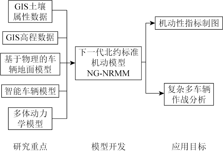
| [3] |
Liu R, Wang J, Zhang B. High definition map for automated driving:Overview and analysis[J]. Journal of Navigation, 2020, 73(2):324-341.
|
| [4] |
余卓渊, 闾国年, 张夕宁, 等. 全息高精度导航地图:概念及理论模型[J]. 地球信息科学学报, 2020, 22(4):760-771.
doi: 10.12082/dqxxkx.2020.190648
|
| [4] |
Yu Z Y, lyu G N, Zhang X N, et al. Pan-information-based high precision navigation map:Concept and theoretical model[J]. Journal of Geo-Information Science, 2020, 22(4):760-771.
|
| [5] |
张攀, 刘经南. 通用化高精地图数据模型[J]. 测绘学报, 2021, 50(11):1432-1446.
doi: 10.11947/j.AGCS.2021.20210254
|
| [5] |
Zhang P, Liu J N. A generalized data model of high definition maps[J]. Acta Geodaetica et Cartographica Sinica, 2021, 50(11):1432-1446.
doi: 10.11947/j.AGCS.2021.20210254
|
| [6] |
Ibisch P L, Hoffmann M T, Kreft S, et al. A global map of roadless areas and their conservation status[J]. Science, 2016, 354(6318):1423-1427.
pmid: 27980208
|
| [7] |
Jayakumar P, Gorsich D, Hudson C, et al. Quantitative assessment of modelling and simulation tools for autonomous navigation of military vehicles over off-road terrains[J]. International Journal of Vehicle Performance, 2020, 6(3):327.
|
| [8] |
于海波, 吴必虎. 国外自驾游研究进展[J]. 旅游学刊, 2011, 26(3):55-61.
|
| [8] |
Yu H B, Wu B H. Progress about the study of overseas self-driving travel[J]. Tourism Tribune, 2011, 26(3):55-61.
|
| [9] |
Ort T, Paull L, Rus D. Autonomous vehicle navigation in rural environments without detailed prior maps[C]// 2018 IEEE International Conference on Robotics and Automation (ICRA).Brisbane,QLD,Australia.IEEE, 2018:2040-2047.
|
| [10] |
刁增祥, 余建星. 军用车辆的机动性等级和模型[J]. 汽车工程, 2005, 27(3):354-357.
|
| [10] |
Diao Z X, Yu J X. Mobility grade and model of military vehicles[J]. Automotive Engineering, 2005, 27(3):354-357.
|
| [11] |
余志生. 汽车理论[M]. 北京: 机械工业出版社, 2019.
|
| [11] |
Yu Z S. Automobile theory[M]. Beijing: China Machine Press, 2019.
|
| [12] |
Rada J, Rybansky M, Dohnal F. The impact of the accuracy of terrain surface data on the navigation of off-road vehicles[J]. ISPRS International Journal of Geo-Information, 2021, 10(3):106.
|
| [13] |
孙昂, 杨清华, 刘智, 等. 西里古里走廊地区道路交通:分布特征、通行能力与地质环境[J]. 自然资源遥感, 2021, 33(3):138-147.doi:10.6046/zrzyyg.2020421.
|
| [13] |
Sun A, Yang Q H, Liu Z, et al. Transportation in the Siliguri Corridor,West Bengal,India:Distribution characteristics,trafficability,and geological environment[J]. Remote Sensing for Natural Resources, 2021, 33(3):138-147.doi:10.6046/zrzyyg.2020421.
|
| [14] |
李德仁, 张过, 蒋永华, 等. 论大数据视角下的地球空间信息学的机遇与挑战[J]. 大数据, 2022, 8(2):3-14.
doi: 10.11959/j.issn.2096-0271.2022012
|
| [14] |
Li D R, Zhang G, Jiang Y H, et al. Opportunities and challenges of geo-spatial information science from the perspective of big data[J]. Big Data Research, 2022, 8(2):3-14.
|
| [15] |
冯权泷, 牛博文, 朱德海, 等. 土地利用/覆被深度学习遥感分类研究综述[J]. 农业机械学报, 2022, 53(3):1-17.
|
| [15] |
Feng Q L, Niu B W, Zhu D H, et al. Review for deep learning in land use and land cover remote sensing classification[J]. Transactions of the Chinese Society for Agricultural Machinery, 2022, 53(3):1-17.
|
| [16] |
康晋洁, 戚浩平, 杨清华, 等. 道路通行障碍物遥感检测与通过性评价[J]. 国土资源遥感, 2020, 32(2):94-102.doi:10.6046/gtzyyg.2020.02.13.
|
| [16] |
Kang J J, Qi H P, Yang Q H, et al. Study of remote sensing detection method for road obstacle and accessibility evaluation[J]. Remote Sensing for Land and Resources, 2020, 32(2):94-102.doi:10.6046/gtzyyg.2020.02.13.
|
| [17] |
郑雄伟, 彭孛, 尚坤. 基于国产卫星的遥感地质解译能力评估[J]. 自然资源遥感, 2021, 33(3):1-10.doi:10.6046/zrzyyg.2020357.
|
| [17] |
Zheng X W, Peng B, Shang K. Assessment of the interpretation ability of domestic satellites in geological remote sensing[J]. Remote Sensing for Natural Resources, 2021, 33(3):1-10.doi:10.6046/zrzyyg.2020357.
|
| [18] |
梁茜亚, 王卷乐, 李朋飞, 等. 基于GF-1影像的蒙古高原干旱半干旱地区自然道路提取——以蒙古国古尔班特斯苏木为例[J]. 自然资源遥感, 2023, 35(2):122-131.doi:10.6046/zrzyyg.2022117.
|
| [18] |
Liang X Y, Wang J L, Li P F, et al. GF-1 images-based information extraction of natural roads in arid and semi-arid regions of the Mongolian Plateau:A case study of Gurvantes Soum,Mongolia[J]. Remote Sensing for Natural Resources, 2023, 35(2):122-131.doi:10.6046/zrzyyg.2022117.
|
| [19] |
陈富强, 刘亚林, 高旭, 等. 遥感技术在中尼铁路工程地质勘察中的应用[J]. 自然资源遥感, 2021, 33(4):219-226.doi:10.6046/zrzyyg.2020403.
|
| [19] |
Chen F Q, Liu Y L, Gao X, et al. Application of remote sensing technology to the engineering geological survey for the construction of the China-Nepal railway[J]. Remote Sensing for Natural Resources, 2021, 33(4):219-226.doi:10.6046/zrzyyg.2020403.
|
| [20] |
辛荣芳, 李宗仁, 张焜, 等. 青海省湟水流域地质灾害动态变化遥感监测[J]. 自然资源遥感, 2022, 34(4):254-261.doi:10.6046/zrzyyg.2021313.
|
| [20] |
Xin R F, Li Z R, Zhang K, et al. Remote sensing monitoring of the dynamic changes in geologic hazards in the Huangshui River Basin of Qinghai Province[J]. Remote Sensing for Natural Resources, 2022, 34(4):254-261.doi:10.6046/zrzyyg.2021313.
|
| [21] |
王绚, 范宣梅, 杨帆, 等. 植被茂密山区地质灾害遥感解译方法研究[J]. 武汉大学学报(信息科学版), 2020, 45(11):1771-1781.
|
| [21] |
Wang X, Fan X M, Yang F, et al. Remote sensing interpretation method of geological hazards in lush mountainous area[J]. Geomatics and Information Science of Wuhan University, 2020, 45(11):1771-1781.
|
| [22] |
Wong J Y. Theory of ground vehicles[M]. Hoboken: Wiley, 2022.
|
| [23] |
李坤伟, 游雄, 张欣, 等. 基于多源数据的土壤越野通行性评估[J]. 测绘科学技术学报, 2018, 35(2):206-210.
|
| [23] |
Li K W, You X, Zhang X, et al. Evaluation of soil trafficability based on multi-source data[J]. Journal of Geomatics Science and Technology, 2018, 35(2):206-210.
|
| [24] |
艾璐, 孙淑怡, 李书光, 等. 光学与SAR遥感协同反演土壤水分研究进展[J]. 自然资源遥感, 2021, 33(4):10-18.doi:10.6046/zrzyyg.2020416.
|
| [24] |
Ai L, Sun S Y, Li S G, et al. Research progress on the cooperative inversion of soil moisture using optical and SAR remote sensing[J]. Remote Sensing for Natural Resources, 2021, 33(4):10-18.doi:10.6046/zrzyyg.2020416.
|
| [25] |
Ewing J, Oommen T, Jayakumar P, et al. Utilizing hyperspectral remote sensing for soil gradation[J]. Remote Sensing, 2020, 12(20):3312.
|
| [26] |
Bousbih S, Zribi M, Pelletier C, et al. Soil texture estimation using radar and optical data from sentinel-1 and sentinel-2[J]. Remote Sensing, 2019, 11(13):1520.
|
| [27] |
蒋玲梅, 崔慧珍, 王功雪, 等. 积雪、土壤冻融与土壤水分遥感监测研究进展[J]. 遥感技术与应用, 2020, 35(6):1237-1262.
doi: 10.11873/j.issn.1004-0323.2020.6.1237
|
| [27] |
Jiang L M, Cui H Z, Wang G X, et al. Progress on remote sensing of snow,surface soil frozen/thaw state and soil moisture[J]. Remote Sensing Technology and Application, 2020, 35(6):1237-1262.
|
| [28] |
Zhang T, Barry R G, Knowles K, et al. Statistics and characteristics of permafrost and ground-ice distribution in the Northern Hemisphere[J]. Polar Geography, 2008, 31(1/2):47-68.
|
| [29] |
姚禹, 王博, 高智. 履带-地面耦合系统机理分析与建模[J]. 长春工业大学学报, 2018, 39(6):528-533,633.
|
| [29] |
Yao Y, Wang B, Gao Z. Mechanism analysis and modeling of track-soil coupling system[J]. Journal of Changchun University of Technology, 2018, 39(6):528-533,633.
|
| [30] |
陈鼎. 基于地面分形特性的轮地相互作用机理研究及其应用[D]. 厦门: 厦门大学, 2019.
|
| [30] |
Chen D. Research and application of tire-soil interaction mechanism based on soil fractal characteristics[D]. Xiamen: Xiamen University, 2019.
|
| [31] |
华琛, 牛润新, 余彪. 地面车辆机动性评估方法与应用[J]. 吉林大学学报(工学版), 2022, 52(6):1229-1244.
|
| [31] |
Hua C, Niu R X, Yu B. Methods and applications of ground vehicle mobility evaluation[J]. Journal of Jilin University (Engineering and Technology Edition), 2022, 52(6):1229-1244.
|
| [32] |
邵芸, 张茗, 谢酬. 地质灾害遥感综合监测现状与展望[J]. 地质与资源, 2022, 31(3):381-394.
|
| [32] |
Shao Y, Zhang M, Xie C. Present situation and prospect of comprehensive monitoring in geological hazard by remote sensing[J]. Geology and Resources, 2022, 31(3):381-394.
|
| [33] |
许强. 对地质灾害隐患早期识别相关问题的认识与思考[J]. 武汉大学学报(信息科学版), 2020, 45(11):1651-1659.
|
| [33] |
Xu Q. Understanding and consideration of related issues in early identification of potential geohazards[J]. Geomatics and Information Science of Wuhan University, 2020, 45(11):1651-1659.
|
| [34] |
高扬骏, 李广云, 吕志伟. 卫星导航干扰技术的现状及展望[J]. 测绘与空间地理信息, 2022, 45(6):13-18.
|
| [34] |
Gao Y J, Li G Y, Lyu Z W. Current situation and prospect of satellite navigation interference technology[J]. Geomatics & Spatial Information Technology, 2022, 45(6):13-18.
|
| [35] |
王君, 郭妍, 唐康华, 等. 卫星导航欺骗式干扰技术发展趋势综述[J]. 导航与控制, 2022, 21(1):13-24.
doi: 10.3969/j.issn.1674-5558.2022.01.002
|
| [35] |
Wang J, Guo Y, Tang K H, et al. Development trend of spoofing jamming technology for satellite navigation[J]. Navigation and Control, 2022, 21(1):13-24.
doi: 10.3969/j.issn.1674-5558.2022.01.002
|
| [36] |
黄龙, 唐小妹, 王飞雪. 卫星导航接收机抗欺骗干扰方法研究[J]. 武汉大学学报(信息科学版), 2011, 36(11):1344-1347.
|
| [36] |
Huang L, Tang X M, Wang F X. Anti-spoofing techniques for GNSS receiver[J]. Geomatics and Information Science of Wuhan University, 2011, 36(11):1344-1347.
|
| [37] |
Babapour R, Naghdi R, Ghajar I, et al. Forest road profile optimization using meta-heuristic techniques[J]. Applied Soft Computing, 2018, 64:126-137.
|
| [38] |
Casal G, Santamarina D, Vázquez-Méndez M E. Optimization of horizontal alignment geometry in road design and reconstruction[J]. Transportation Research Part C:Emerging Technologies, 2017, 74:261-274.
|
| [39] |
Park J, Abdel-Aty M. Safety performance of combinations of traffic and roadway cross-sectional design elements at straight and curved segments[J]. Journal of Transportation Engineering,Part A:Systems, 2017, 143(6):04017015.
|
| [40] |
霍凤财, 迟金, 黄梓健, 等. 移动机器人路径规划算法综述[J]. 吉林大学学报(信息科学版), 2018, 36(6):639-647.
|
| [40] |
Huo F C, Chi J, Huang Z J, et al. Review of path planning for mobile robots[J]. Journal of Jilin University (Information Science Edition), 2018, 36(6):639-647.
|
| [41] |
李晓旭, 马兴录, 王先鹏. 移动机器人路径规划算法综述[J]. 计算机测量与控制, 2022, 30(7):9-19.
|
| [41] |
Li X X, Ma X L, Wang X P. A survey of path planning algorithms for mobile robots[J]. Computer Measurement & Control, 2022, 30(7):9-19.
|
| [42] |
闫皎洁, 张锲石, 胡希平. 基于强化学习的路径规划技术综述[J]. 计算机工程, 2021, 47(10):16-25.
doi: 10.19678/j.issn.1000-3428.0060683
|
| [42] |
Yan J J, Zhang Q S, Hu X P. Review of path planning techniques based on reinforcement learning[J]. Computer Engineering, 2021, 47(10):16-25.
doi: 10.19678/j.issn.1000-3428.0060683
|
| [43] |
Cook J T, Ray L E, Lever J H. Dynamics modeling and robotic-assist,leader-follower control of tractor convoys[J]. Journal of Terramechanics, 2018, 75:57-72.
|
| [44] |
Godoy J, Artuñedo A, Beteta M, et al. Corridors-based navigation for automated vehicles convoy in off-road environments[J]. IFAC-PapersOnLine, 2022, 55(14):71-76.
|
| [45] |
Mao W, Liu Z, Liu H, et al. Research progress on synergistic technologies of agricultural multi-robots[J]. Applied Sciences, 2021, 11(4):1448.
|
| [46] |
Haley P W, Jurkat M P, Brady Jr P M, et al. NATO reference mobility model,Edition 1,Users guide.Volume 2.Obstacle Module[R].(1979).
|
| [47] |
Bradbury M, Dasch J, Gonzalez R, et al. Next-generation NATO reference mobility model (NG-NRMM)[J]. Tank Automotive Research,Development and Engineering Center (TARDEC),Warren,MI, 2016.
|
| [48] |
Wong J Y, Jayakumar P, Toma E, et al. A review of mobility metrics for next generation vehicle mobility models[J]. Journal of Terramechanics, 2020, 87:11-20.
doi: 10.1016/j.jterra.2019.10.003
|
| [49] |
McCullough M, Jayakumar P, Dasch J, et al. The Next Generation NATO Reference mobility model development[J]. Journal of Terramechanics, 2017, 73:49-60.
|
| [50] |
Wasfy T, Jayakumar P. Next-generation NATO reference mobility model complex terramechanics-part 1:Definition and literature review[J]. Journal of Terramechanics, 2021, 96:45-57.
|
|
Viewed |
|
|
|
Full text
|
|
|
|
|
Abstract
|
|
|
|
|
Cited |
|
|
|
|
| |
Shared |
|
|
|
|
| |
Discussed |
|
|
|
|
 2024,
Vol. 36
2024,
Vol. 36