|
|
 |
|

|
|
|
Imaging modeling of integrated imaging spectrometers for undulating terrain with uneven surface feature distribution |
CUI Bolun1( ), LI Xin1, AN Ning1, TONG Chiming1, ZHANG Jiaming1, ZHU Jun2 ), LI Xin1, AN Ning1, TONG Chiming1, ZHANG Jiaming1, ZHU Jun2 |
1. Beijing Institute of Space Mechanics and Electricity, Beijing 100094, China
2. China Spacesat Co., Ltd., Beijing 100094, China |
|
|
|
|
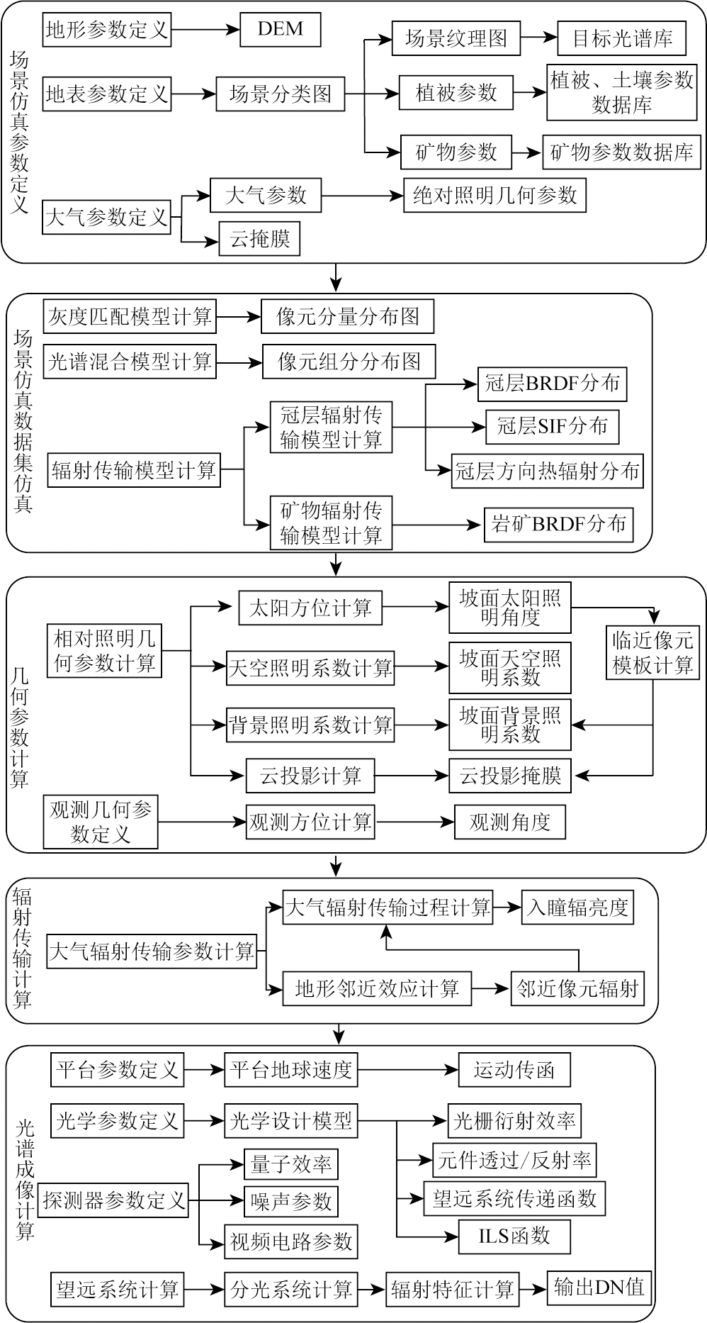
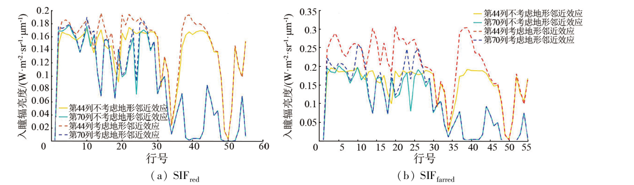
Abstract Integrated imaging spectrometers can effectively improve the monitoring capability of terrestrial ecosystems. Imaging simulation in the design and development of spectrometers is identified as an important means to improve their efficiency. To overcome the shortcomings of current imaging simulation in scene modeling and radiation transport models, this study developed a full-link hyperspectral imaging simulation model. Using this model, this study conducted preliminary assessments of load efficiency. First, heterogeneous modeling for large-scale scenes was conducted according to the observation targets of loads. Then, a surface radiation transport model containing fluorescence radiation and thermal radiation was derived for undulating terrain with uneven surface feature distribution (also referred to as unevenly undulating surface). Finally, by integrating the imaging model of grating spectrometers, this study established a full-link imaging simulation model. To determine the impacts of the adjacency effect of the unevenly undulating surface on the spatial distribution of solar-induced chlorophyll fluorescence (SIF), this study compared the radiance of red and far-red SIF derived with and without considering the adjacency effect of terrain under the spatial resolution of the used integrated imaging spectrometer. For data on significantly undulating terrain with uneven surface feature distribution, the SIF radiance exhibited differences of up to maxima of 22% and 52%, respectively, and ignoring the adjacency effect led to significant errors in the high-resolution SIF simulations. The imaging modeling method developed in this study can be used for hyperspectral imaging simulation of unevenly undulating surfaces, thus allowing for analyzing the efficiency of integrated imaging spectrometers for composite applications in ecological monitoring.
|
| Keywords
hyperspectral imaging simulation
solar-induced chlorophyll fluorescence
terrestrial ecological monitoring
hyperspectral imaging
|
|
|
|
Issue Date: 23 December 2024
|
|
|
| [1] |
王伟刚, 胡斌, 杜国军, 等. 陆地生态系统碳监测卫星日光诱导叶绿素荧光超光谱探测仪设计与验证[J]. 航天返回与遥感, 2022, 43(6):68-78.
|
| [1] |
Wang W G, Hu B, Du G J, et al. The solar-induced chlorophyll fluorescence imaging spectrometer (SIFIS) onboard the terrestrial ecosystem carbon inventory satellite:Design and verification[J]. Spacecraft Recovery and Remote Sensing, 2022, 43(6):68-78.
|
| [2] |
Zeng Y, Hao D, Huete A, et al. Optical vegetation indices for monitoring terrestrial ecosystems globally[J]. Nature Reviews Earth and Environment, 2022, 3:477-493.
|
| [3] |
Bergen K M, Goetz S J, Dubayah R O, et al. Remote sensing of vegetation 3-D structure for biodiversity and habitat:Review and implications for LiDAR and Radar spaceborne missions[J]. Journal of Geophysical Research:Biogeosciences, 2009, 114(G2):G00E06.
|
| [4] |
Sagan V, Peterson K T, Maimaitijiang M, et al. Monitoring inland water quality using remote sensing:Potential and limitations of spectral indices,bio-optical simulations,machine learning,and cloud computing[J]. Earth-Science Reviews, 2020, 205:103187.
|
| [5] |
Nayak A K, Rahman M M, Naidu R, et al. Current and emerging methodologies for estimating carbon sequestration in agricultural soils:A review[J]. Science of the Total Environment, 2019, 665:890-912.
doi: 10.1016/j.scitotenv.2019.02.125
|
| [6] |
Gu L, Han J, Wood J D, et al. Sun-induced Chl fluorescence and its importance for biophysical modeling of photosynthesis based on light reactions[J]. New Phytologist, 2019, 223(3):1179-1191.
doi: 10.1111/nph.15796
pmid: 30883811
|
| [7] |
Du S, Liu L, Liu X, et al. Response of canopy solar-induced chlorophyll fluorescence to the absorbed photosynthetically active radiation absorbed by chlorophyll[J]. Remote Sensing, 2017, 9(9):911.
|
| [8] |
Coppo P, Pettinato L, Nuzzi D, et al. Instrument predevelopment activities for FLEX mission[J]. Optical Engineering, 2019, 58(7):075102.
|
| [9] |
Clark M L. Comparison of simulated hyperspectral HyspIRI and multispectral Landsat8 and Sentinel-2 imagery for multi-seasonal,regional land-cover mapping[J]. Remote Sensing of Environment, 2017, 200:311-325.
|
| [10] |
Segl K, Guanter L, Rogass C, et al. EeteS—The EnMAP end-to-end simulation tool[J]. IEEE Journal of Selected Topics in Applied Earth Observations and Remote Sensing, 2012, 5(2):522-530.
|
| [11] |
Liu Y, Li N, Ren H, et al. Emissivity image simulation for thermal infrared bands on Gaofen-5 using airborne hyperspectral data[C]// 2017 IEEE International Geoscience and Remote Sensing Symposium (IGARSS).IEEE, 2017:2093-2096.
|
| [12] |
Rivera J P, Sabater N, Tenjo C, et al.Synthetic scene simulator for hyperspectral spaceborne passive optical sensors. Application to ESA’s FLEX/sentinel-3 tandem mission[C]// 2014 6th Workshop on Hyperspectral Image and Signal Processing:Evolution in Remote Sensing (WHISPERS).IEEE, 2014:1-4.
|
| [13] |
Vicent J, Sabater N, Tenjo C, et al. FLEX end-to-end mission performance simulator[J]. IEEE Transactions on Geoscience and Remote Sensing, 2016, 54(7):4215-4223.
|
| [14] |
Tenjo C, Rivera-Caicedo J P, Sabater N, et al. Design of a generic 3-D scene generator for passive optical missions and its implementation for the ESA’s FLEX/Sentinel-3 tandem mission[J]. IEEE Transactions on Geoscience and Remote Sensing, 2018, 56(3):1290-1307.
|
| [15] |
Mousivand A, Verhoef W, Menenti M, et al. Modeling top of atmosphere radiance over heterogeneous non-lambertian rugged terrain[J]. Remote Sensing, 2015, 7(6):8019-8044.
|
| [16] |
Cathala T, Douchin N, Latger J, et al. The coupling of MATISSE and the SE-WORKBENCH:A new solution for simulating efficiently the atmospheric radiative transfer and the sea surface radiation[C]// Proc.SPIE 7300,Infrared Imaging Systems:Design,Analysis,Modeling,and Testing XX, 2009, 7300:188-199.
|
| [17] |
Börner A, Wiest L, Keller P, et al. SENSOR:A tool for the simulation of hyperspectral remote sensing systems[J]. ISPRS Journal of Photogrammetry and Remote Sensing, 2001, 55(5/6):299-312.
|
| [18] |
Goodenough A A, Brown S D. DIRSIG5:Next-generation remote sensing data and image simulation framework[J]. IEEE Journal of Selected Topics in Applied Earth Observations and Remote Sensing, 2017, 10(11):4818-4833.
|
| [19] |
Heylen R, Parente M, Gader P. A review of nonlinear hyperspectral unmixing methods[J]. IEEE Journal of Selected Topics in Applied Earth Observations and Remote Sensing, 2014, 7(6):1844-1868.
|
| [20] |
Yang P, Prikaziuk E, Verhoef W, et al. SCOPE 2.0:A model to simulate vegetated land surface fluxes and satellite signals[J]. Geoscientific Model Development, 2021, 14(7):4697-4712.
|
| [21] |
Gastellu-Etchegorry J P, Lauret N, Yin T, et al. DART:Recent advances in remote sensing data modeling with atmosphere,polarization,and chlorophyll fluorescence[J]. IEEE Journal of Selected Topics in Applied Earth Observations and Remote Sensing, 2017, 10(6):2640-2649.
|
| [22] |
Zhao F, Dai X, Verhoef W, et al. FluorWPS:A Monte Carlo ray-tracing model to compute sun-induced chlorophyll fluorescence of three-dimensional canopy[J]. Remote Sensing of Environment, 2016, 187:385-399.
|
| [23] |
Shi H, Xiao Z. SIFT:Modeling solar-induced chlorophyll fluorescence over sloping terrain[J]. IEEE Geoscience and Remote Sensing Letters, 2021, 19:3002405.
|
| [24] |
Hapke B. Bidirectional reflectance spectroscopy:1.Theory[J]. Journal of Geophysical Research:Solid Earth, 1981, 86(b4):3039-3054.
|
| [25] |
Verhoef W, Bach H. Simulation of hyperspectral and directional radiance images using coupled biophysical and atmospheric radiative transfer models[J]. Remote Sensing of Environment, 2003, 87(1):23-41.
|
| [26] |
Tao D, Jia G, Yuan Y, et al. A digital sensor simulator of the pushbroom Offner hyperspectral imaging spectrometer[J]. Sensors, 2014, 14(12):23822-23842.
doi: 10.3390/s141223822
pmid: 25615727
|
| [27] |
Jacobs E L, Edwards T C. Sampling criteria for sensor simulation[J]. Optical Engineering 1999, 38(5):827-835.
|
| [28] |
Tao D, Zhao H, Jia G, et al. Analyzing the effect of synthetic scene resolution,sampling interval,and signal-to-noise ratio on hyperspectral imaging sensor simulations[J]. Applied Optics, 2014, 53(28):6375-6381.
|
| [29] |
Zanaga D, Van De Kerchove R, De Keersmaecker W, et al. ESA WorldCover 10 m 2020 v100[DB], 2020.
|
| [30] |
Berk A, Conforti P, Kennett R, et al.MODTRAN®6: A major upgrade of the MODTRAN® radiative transfer code[C]// 2014 6th workshop on Hyperspectral Image and Signal Processing Evolution in Remote Sensing(WHISPERS).IEEE, 2014:1-4.
|
| [31] |
Felde G W, Anderson G P, Cooley T W, et al. Analysis of Hyperion data with the FLAASH atmospheric correction algorithm[C]// 2003 IEEE International Geoscience and Remote Sensing Symposium.Proceedings.Toulouse,IEEE, 2003:90-92.
|
| [32] |
DiPietro R S, Manolakis D, Lockwood R B, et al. Hyperspectral matched filter with false-alarm mitigation[J]. Optical Engineering, 2012, 51(1):016202.
|
| [33] |
Du Y, Chang C I, Ren H, et al. New hyperspectral discrimination measure for spectral similarity[J]. Proc.SPIE 5093,Algorithms and Technologies for Multispectral,Hyperspectral,and Ultraspectral Imagery IX, 2003, 5093:430-439.
|
| [34] |
Du S, Liu L, Liu X, et al. The solar-induced chlorophyll fluorescence imaging spectrometer (SIFIS) onboard the first terrestrial ecosystem carbon inventory satellite (TECIS-1):Specifications and prospects[J]. Sensors, 2020, 20(3):815.
|
|
Viewed |
|
|
|
Full text
|
|
|
|
|
Abstract
|
|
|
|
|
Cited |
|
|
|
|
| |
Shared |
|
|
|
|
| |
Discussed |
|
|
|
|
 2024,
Vol. 36
2024,
Vol. 36