|
|
 |
|

|
|
|
Temporal and spatial evolution in landscape pattern of mining site area based on moving window method |
Zhaorong MEI1, Yunju LI2, Xiang KANG1, Shanbao WEI1, Jianjun PAN3( ) ) |
1. College of Public Administration, Nanjing Agricultural University, Nanjing 210095, China
2. National Phosphate Resources Development and Utilization Engineering Technology Research Center, Kunming 650500, China
3. College of Resources and Environment, Nanjing Agricultural University, Nanjing 210095, China |
|
|
|
|
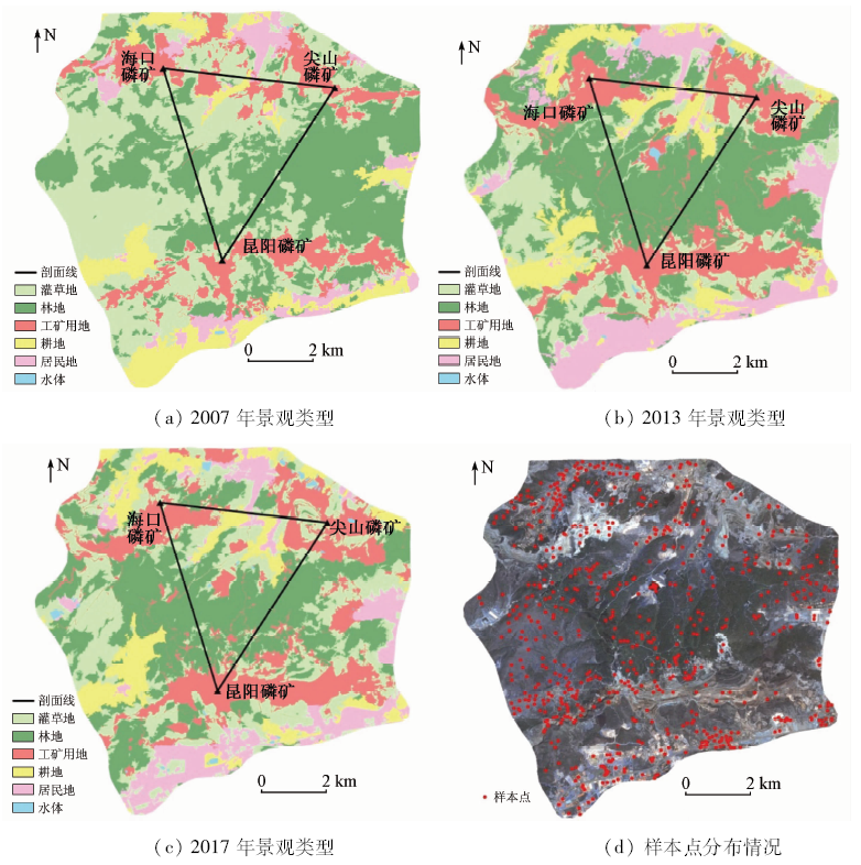
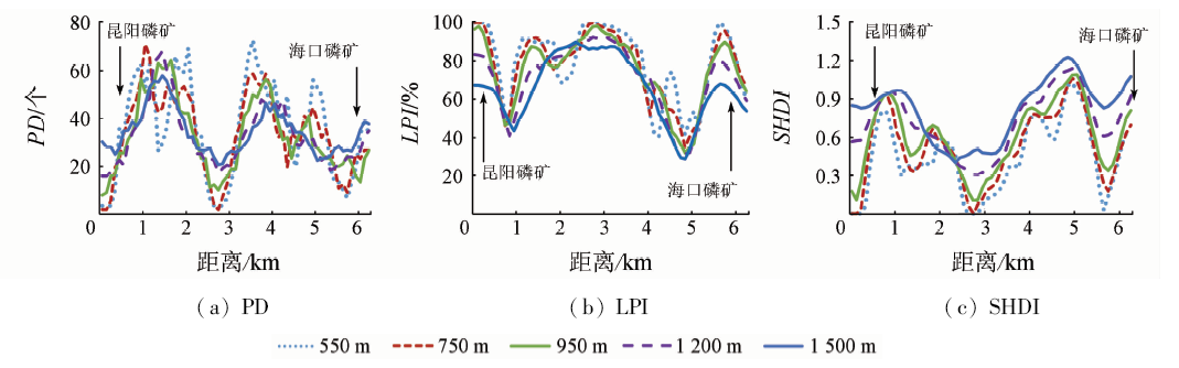
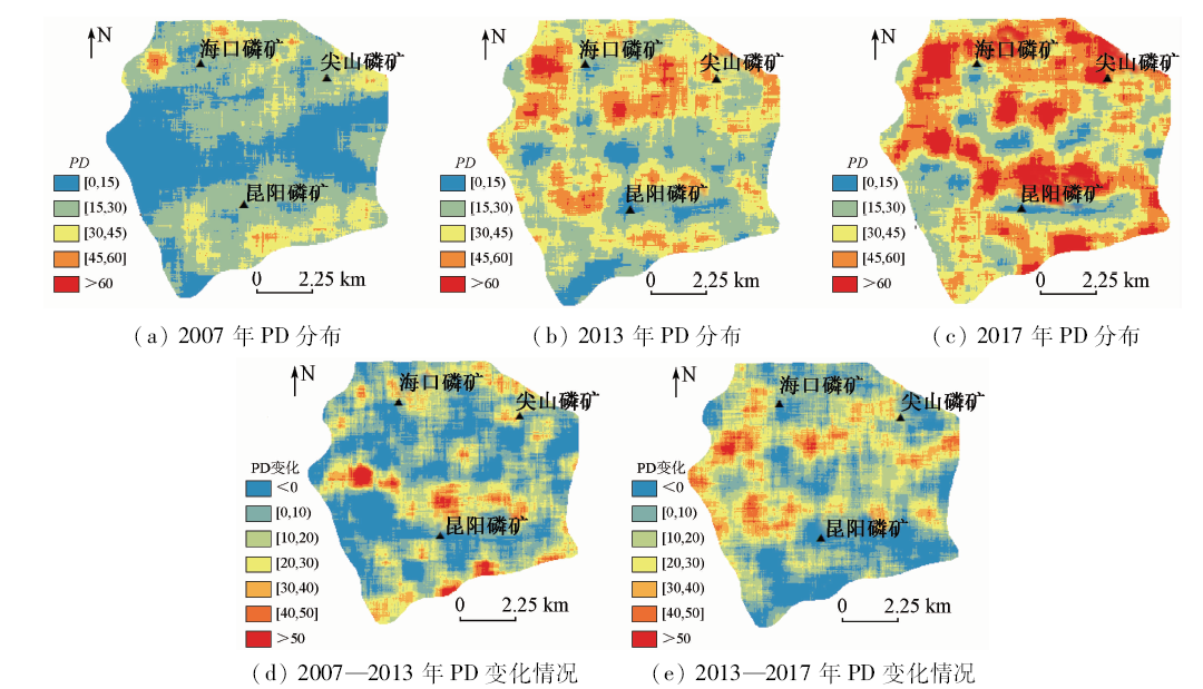
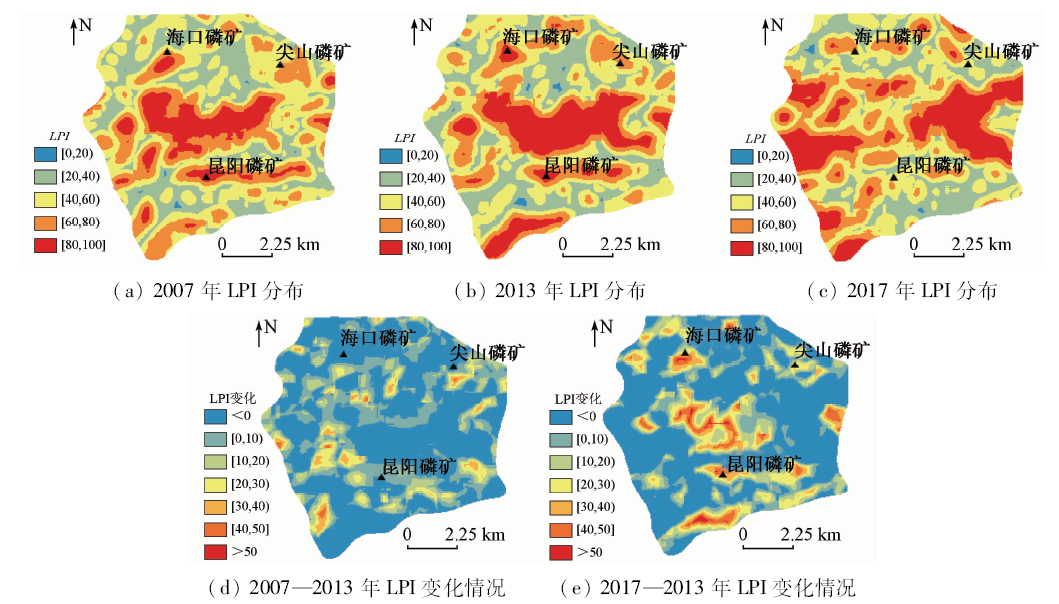
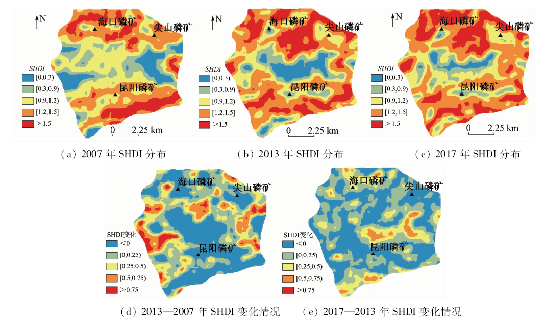
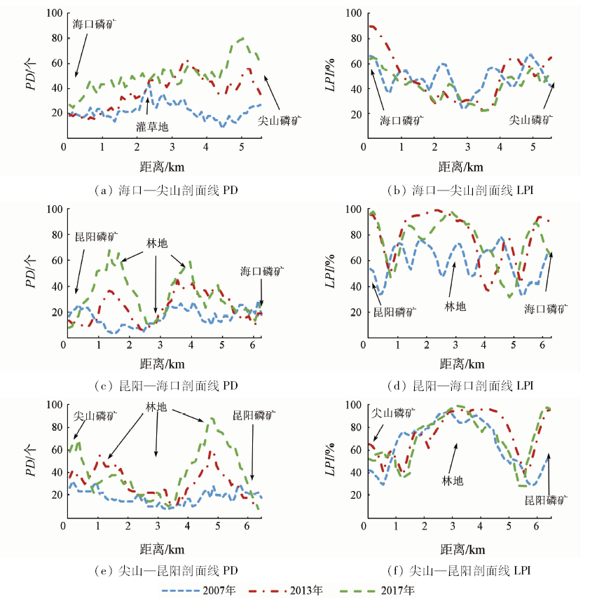
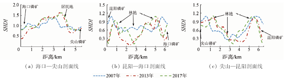
Abstract This study is aimed to discuss the temporal and spatial evolution of landscape pattern under the impact of mining work. With the support of moving window analysis and geographic information system (GIS) technology, the authors extracted the spatial distribution map of landscape fragmentation and diversity index from three remote sensing image data in one open-air mining site in Kunming from 2007 to 2017. On the basis of obtaining landscape types and determining appropriate window scales, the spatial distribution maps of landscape fragmentation and diversity index were extracted, and then mining site cores were connected to build transects for spatial overlay analysis. The result shows that, under the most suitable window range of 950 m, the high value center of landscape fragmentation and diversity index spread from the regional edge to the center from 2007 to 2017. The effect of patch aggregation in open mining area was remarkable, and the fragmentation and diversity effect of surrounding area in nearly 1~2 km were obvious year by year. At the same time, the area beyond 2.5 km of the mining center was on the whole not affected by mining activities. The result visually shows the rule for the temporal and spatial evolution of landscape pattern affected by mining activities, and the result can provide data support for follow-up work.
|
| Keywords
mining activities
moving window analysis
GIS technology
landscape pattern index
|
|
|
|
Corresponding Authors:
Jianjun PAN
E-mail: jpan@njau.edu.cn
|
|
Issue Date: 03 December 2019
|
|
|
| [1] |
陈文波, 肖笃宁, 李秀珍 . 景观空间分析的特征和主要内容[J]. 生态学报, 2002,22(7):1136-1142.
|
| [1] |
Chen W B, Xiao D N, Li X Z . The characteristics and contents of landscape spatial analysis[J]. Aca Ecoligica Sinica, 2002,22(7):1135-1142.
|
| [2] |
苏常红, 傅伯杰 . 景观格局与生态过程的关系及其对生态系统服务的影响[J]. 自然杂志, 2012,34(5):277-283.
|
| [2] |
Su C H, Fu B J . Discussion on links among landscape pattern,ecological process,and ecosystem services[J]. Chinese Journal of Nature, 2012,34(5):277-283.
|
| [3] |
邬建国 . 景观生态学——格局、过程、尺度与等级[M]. 北京: 高等教育出版社, 2007: 19-20.
|
| [3] |
Wu J G. Landscape Ecology:Pattern,Process,Scale and Hierarchy[M]. Beijing: Higher Education Press, 2007: 19-20.
|
| [4] |
陈宇, 陈绍杰, 杜培军 , 等. 基于国产小卫星遥感数据的矿区土地覆盖与景观格局变化研究[J].遥感信息,2012(2):85-90.
|
| [4] |
Chen Y, Chen S J, Du P J , et al. Change analysis of land cover and landscape pattern in coal mining area based on China small satellite remote sensing data[J].Remote Sensing Information,2012(2):85-90.
|
| [5] |
韩武波, 贾薇, 孙泰森 . 基于3S的平朔矿区土地利用及景观格局演变研究[J]. 中国土地科学, 2012,26(4):60-65.
|
| [5] |
Han W B, Jia W, Sun T S . Change of land use and landscape pattern in Pingshuo open coal mines based on the 3S technology[J]. China Land Science, 2012,26(4):60-65.
|
| [6] |
高翔, 蔡雄飞, 王济 , 等. 贵州典型矿区10年景观格局变化及驱动力分析[J]. 环境科学与技术, 2013,36(11):168-174.
|
| [6] |
Gao X, Cai X F, Wang J , et al. Analysis of landscape pattern change and its driving forces in typical mining area of Guizhou Province during 10 years[J]. Environment Science and Technology, 2013,36(11):168-174.
|
| [7] |
谭丽, 何兴元, 陈玮 , 等. 基于QuickBird卫星影像的沈阳城市绿地景观格局梯度分析[J]. 生态学杂志, 2008,27(7):1141-1148.
doi:
|
| [7] |
Tan L, He X Y, Chen W , et al. Gradient analysis of urban green space landscape pattern in Shenyang City based on QuickBird image[J]. Chinese Journal of Ecology, 2008,27(7):1141-1148.
|
| [8] |
徐晓然, 谢跟踪, 邱彭华 . 1964 —2015年海南省八门湾红树林湿地及其周边土地景观动态分析[J]. 生态学报, 2018(20):1-10.
|
| [8] |
Xu X R, Xie G Z, Qiu P H , et al.Dynamic analysis of landscape changes in Bamen port and the surrounding lands of Hainan Provience from 1964 to 2015[J]. Acta Ecologica Sinica, 2018(20):1-10.
|
| [9] |
Whittaker R H . Vegetation of the Siskiyou Mountains,Oregon and California[J]. Ecological Monographs, 1960,30(4):279-338.
|
| [10] |
张玲玲, 赵永华, 殷莎 , 等. 基于移动窗口法的岷江干旱河谷景观格局梯度分析[J]. 生态学报, 2014,34(12):3276-3284.
doi: 10.5846/stxb201310312639
url: http://d.wanfangdata.com.cn/Thesis_D557941.aspx
|
| [10] |
Zhang L L, Zhao Y H, Yin S , et al. Gradient analysis of dry valley of Minjiang River landscape pattern,based on moving window method[J]. Acta Ecologica Sinica, 2014,34(12):3276-3284.
|
| [11] |
刘琦, 刘世梁, 赵清贺 , 等. 基于移动窗口法的水电开发影响下景观格局梯度分析[J]. 山地学报, 2012,30(5):628-635.
|
| [11] |
Liu Q, Liu S L, Zhao Q H , et al. Gradient analysis of landscape pattern affected by hydroelectric station based on moving window method[J]. Journal of Mountain, 2012,30(5):628-635.
|
| [12] |
李栋科, 丁圣彦, 梁国付 , 等. 基于移动窗口法的豫西山地丘陵地区景观异质性分析[J]. 生态学报, 2014,34(12):3414-3424.
doi: 10.5846/stxb201310282595
url: http://d.wanfangdata.com.cn/Periodical/stxb201412030
|
| [12] |
Li D K, Ding S Y, Liang G F , et al. Landscape heterogeneity of mountainous and hilly area in the western Henan Province based on moving window method[J]. Acta Ecologica Sinica, 2014,34(12):3414-3424.
|
| [13] |
张琳琳, 孔繁花, 尹海伟 , 等. 基于景观空间指标与移动窗口的济南城市空间格局变化[J]. 生态学杂志, 2010,29(8):1591-1598.
|
| [13] |
Zhang L L, Kong F H, Yin H W , et al. Spatial pattern change of Jinan City based on landscape metrics and moving window method[J]. Chinese Journal of Ecology, 2010,29(8):1591-1598.
|
| [14] |
刘昕, 国庆喜 . 基于移动窗口法的中国东北地区景观格局[J]. 应用生态学报, 2009,20(6):1415-1422.
doi:
|
| [14] |
Liu X, Guo Q X . Landscape pattern in northeast China based on moving window method[J]. Chinese Journal of Applied Ecology, 2009,20(6):1415-1422.
|
| [15] |
谢晓仪, 曾咺, 李军 . 基于移动窗口法和栅格数据的重庆市人居环境自然适宜性评价[J]. 长江流域资源与环境, 2014,23(10):1351-1359.
doi: 10.11870/cjlyzyyhj201410003
|
| [15] |
Xie X Y, Zeng X, Li J . Evaluation of nature suitability for human settlement in Chongqing[J]. Resources and Environment in the Yangtze Basin, 2014,23(10):1351-1359.
|
| [16] |
张立平, 张世文, 叶回春 , 等. 露天煤矿区土地损毁与复垦景观指数分析[J]. 资源科学, 2014,36(1):55-64.
|
| [16] |
Zhang L P, Zhang S W, Ye H C , et al. Landscape indices of land damage and land reclamation in an opencast coal mine[J]. Resource Science, 2014,36(1):55-64.
|
| [17] |
陆凤连, 王新闯, 张合兵 , 等. 1980—2015年焦作矿区景观格局演变及驱动力分析[J]. 水土保持研究, 2018,25(4):237-243.
|
| [17] |
Lu F L, Wang X C, Zhang H B , et al. Landscape pattern change and its driving force in Jiaozuo mining area from 1980 to 2015[J]. Research of Soil and Water Conservation, 2018,25(4):237-243.
|
| [18] |
李存军, 刘良云, 王纪华 , 等. 两种高保真遥感影像融合方法比较[J]. 中国图象图形学报, 2004,9(11):1376-1385.
doi: 10.11834/jig.2004011265
|
| [18] |
Li C J, Liu L Y, Wang J H , et al. Comparison of two methods of fusing remote sensing images with fidelity of spectral information[J]. Journal of Image and Graphics, 2004,9(11):1376-1385.
|
| [19] |
刘二佳, 罗志东, 张晓丽 , 等. 面向GF-1数据不同融合方法对扰动地块的提取[J].水土保持学报,2018(3):358-363.
|
| [19] |
Liu E J, Luo Z D, Zhang X L , et al. Comparison of fusion algorithms for GF-1 data from extracted of distribution information on production and construction projects[J].Journal of Soil and Water Conservation,2018(3):358-363.
|
| [20] |
宋亚婷, 江东, 黄耀欢 , 等. 基于面向对象方法的露天煤矿用地类型提取优先级分析[J]. 遥感技术与应用, 2016,31(3):572-579.
doi: 10.11873/j.issn.1004-0323.2016.3.0572
|
| [20] |
Song Y T, Jiang D, Huang Y H , et al. Research on the priority of the land use types extraction of opencast mine area based on oriented classification[J]. Remote Sensing Technology and Application, 2016,31(3):572-579.
|
| [21] |
游丽平, 林广发, 杨陈照 , 等. 景观指数的空间尺度效应分析——以厦门岛土地利用格局为例[J]. 地球信息科学学报, 2008,10(1):74-79.
doi: 10.3969/j.issn.1560-8999.2008.01.013
url: http://d.wanfangdata.com.cn/Periodical/dqxxkx200801013
|
| [21] |
You L P, Lin G F, Yang C Z , et al. The effects of spatial scales on landscape indices:A case study of the land use pattern of Xiamen Island[J]. Journal of Geo-Information Science, 2008,10(1):74-79.
|
| [22] |
徐丽, 卞晓庆, 秦小林 , 等. 空间粒度变化对合肥市景观格局指数的影响[J]. 应用生态学报, 2010,21(5):1167-1173.
|
| [22] |
Xu L, Bian X Q, Qin X L , et al. Effects of grain size change on landscape pattern indices of Heifei City[J]. Chinese Journal of Applied Ecology, 2010,21(5):1167-1173.
|
|
Viewed |
|
|
|
Full text
|
|
|
|
|
Abstract
|
|
|
|
|
Cited |
|
|
|
|
| |
Shared |
|
|
|
|
| |
Discussed |
|
|
|
|
 2019,
Vol. 31
2019,
Vol. 31