|
|
|
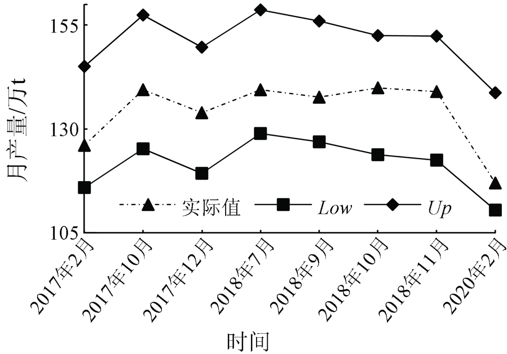
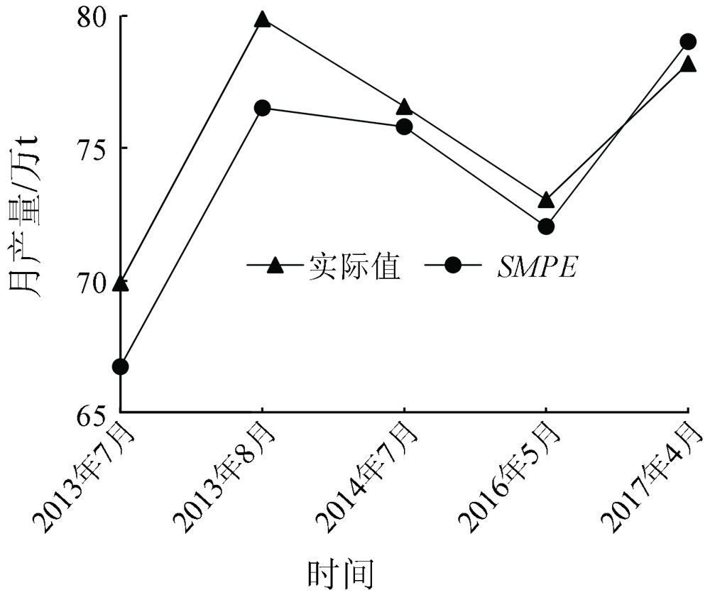
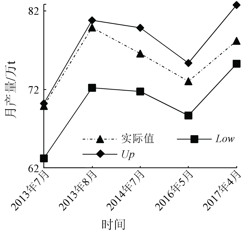
Abstract The iron and steel industry is a very important part in economic development. Obtaining the knowledge of the monthly production of steel companies is conducive to the macro control of the economy and the rational allocation of resources. In this paper, a monthly production estimation model for steel companies was proposed based on the grading results of the surface temperature obtained from the inversion of satellite thermal infrared data as well as the theory and method of landscape pattern indices. The surface temperature anomalous values and the thermal landscape distribution parameters of steel companies can be calculated according to the vector data of the spatial framework of steel companies. Based on this and the actual monthly production data of two typical steel companies in Central China and North China, the estimation model was established through the least-squares fitting, and the coefficient of determination (R2) of the model was greater than 0.9. According to the posterior variance test results, the accuracy of the estimation model proposed in this study is level 2. Meanwhile, the actual production values all fall within the 95% confidence interval of the estimation values. All these comprehensively reflect the monthly production model proposed in this paper are highly accurate.
|
| Keywords
thermal infrared remote sensing
landscape pattern index
steelmaking monthly production estimation model
posterior variance test
|
|
|
|
Corresponding Authors:
SONG Yan
E-mail: liteya@cug.edu.cn;songyan@cug.edu.cn
|
|
Issue Date: 23 December 2021
|
|
|
| [1] |
Wu Y. The Chinese steel industry:Recent developments and prospects[J]. Resources Policy, 2000,26(3):171-178.
doi: 10.1016/S0301-4207(00)00026-X
url: https://linkinghub.elsevier.com/retrieve/pii/S030142070000026X
|
| [2] |
Hua L Z, Zhang X X, Nie Q, et al. The impacts of the expansion of urban impervious surfaces on urban heat islands in a coastal city in China[J]. Sustainability, 2020,12(2):475.
doi: 10.3390/su12020475
url: https://www.mdpi.com/2071-1050/12/2/475
|
| [3] |
董家集, 任华忠, 郑逸童, 等. 基于多源遥感数据的城市环境宜居性研究——以北京市为例[J]. 国土资源遥感, 2020,32(3):165-172.doi: 10.6046/gtzyyg.2020.03.22.
doi: 10.6046/gtzyyg.2020.03.22
|
| [3] |
Dong J J, Ren H Z, Zhen Y T, et al. A study of the livability of urban environment based on multi-source remote sensing data:A case study of Beijing City[J]. Remote Sensing for Land and Resources, 2020,32(3):165-172.doi: 10.6046/gtzyyg.2020.03.22.
doi: 10.6046/gtzyyg.2020.03.22
|
| [4] |
Arslan E, Erenoglu R C. Assessment of hotspots using sparse autoencoder in industrial zones[J]. Environmental Monitoring and Assessment, 2019,191(7):453.
doi: 10.1007/s10661-019-7572-3
pmid: 31222399
|
| [5] |
李静, 孙强强, 张平, 等. 基于多时相热红外遥感的钢铁企业生产状态辅助监测[J]. 国土资源遥感, 2019,31(1):220-228.doi: 10.6046/gtzyyg.2019.01.29.
doi: 10.6046/gtzyyg.2019.01.29
|
| [5] |
Li J, Sun Q Q, Zhang P, et al. A study of auxiliary monitoring in iron and steel plant based on multi-temporal thermal infrared remote sensing[J]. Remote Sensing for Land and Resources, 2019,31(1):220-228.doi: 10.6046/gtzyyg.2019.01.29.
doi: 10.6046/gtzyyg.2019.01.29
|
| [6] |
吴未, 许丽萍, 张敏, 等. 不同斑块类型的景观指数粒度效应响应——以无锡市为例[J]. 生态学报, 2016,36(9):2740-2749.
|
| [6] |
Wu W, Xu L P, Zhang M, et al. Impact of landscape metrics on grain size effect in different types of patches:A case study of Wuxi City[J]. Acta Ecologica Sinica, 2016,36(9):2740-2749.
|
| [7] |
唐新明, 王鸿燕, 祝小勇. 资源三号卫星测绘技术与应用[J]. 测绘学报, 2017,46(10):1482-1491.
|
| [7] |
Tang X M, Wang H Y, Zhu X Y, et al. Technology and applications of surveying and mapping for ZY-3 satellites[J]. Acta Geodaetica et Cartographica Sinica, 2017,46(10):1482-1491.
|
| [8] |
田国良, 柳钦火, 陈良富. 热红外遥感[M]. 北京: 电子工业出版社, 2014.
|
| [8] |
Tian G L, Liu Q H, Chen L F. Thermal remote sensing[M]. Beijing:Publishing House of Electronics Industry, 2014.
|
| [9] |
Walker M L, Dovoedo Y H, Chakraborti S, et al. An improved boxplot for univariate data[J]. The American Statistician, 2018,72(4):348-353.
doi: 10.1080/00031305.2018.1448891
url: https://www.tandfonline.com/doi/full/10.1080/00031305.2018.1448891
|
| [10] |
张玉敏. 基于攀钢炼钢厂车间布局视角的SLP优化设计研究[J]. 物流技术, 2013,32(5):418-421,442.
|
| [10] |
Zhang Y M. An SLP perspective on layout optimization for steel-making workshops of Pangang[J]. Logistics Technology, 2013,32(5):418-421,442.
|
| [11] |
Sekertekin A, Kutoglu S H, Kaya S. Evaluation of spatio-temporal variability in Land Surface Temperature:A case study of Zonguldak,Turkey[J]. Environmental Monitoring & Assessment, 2016,188(1):1-15.
|
| [12] |
El-Hattab M, Amany S M, Lamia G E. Monitoring and assessment of urban heat islands over the Southern region of Cairo Governorate,Egypt[J]. The Egyptian Journal of Remote Sensing and Space Science, 2018,21(3):311-323.
doi: 10.1016/j.ejrs.2017.08.008
url: https://linkinghub.elsevier.com/retrieve/pii/S1110982317301114
|
| [13] |
Mujabar P S. Spatial-temporal variation of land surface temperature of Jubail Industrial City,Saudi Arabia due to seasonal effect by using Thermal Infrared Remote Sensor (TIRS) satellite data[J]. Journal of African Earth Sciences, 2019,155:54-63.
doi: 10.1016/j.jafrearsci.2019.03.008
|
| [14] |
Nádudvari A, Abramowicz A, Maniscalco R, et al. The estimation of lava fow temperatures using Landsat night-time images:Case studies from eruptions of Mt. Etna and Stromboli (Sicily,Italy),Kīlauea (Hawaii Island),and Eyjafallajökull and Holuhraun (Iceland)[J]. Remote Sensing, 2020,12(16):2537.
doi: 10.3390/rs12162537
url: https://www.mdpi.com/2072-4292/12/16/2537
|
| [15] |
李召良, 段四波, 唐伯惠, 等. 热红外地表温度遥感反演方法研究进展[J]. 遥感学报, 2016,20(5):899-920.
|
| [15] |
Li Z L, Duan S B, Tang B H, et al. Review of methods for land surface temperature derived from thermal infrared remotely sensed data[J]. Journal of Remote Sensing, 2016,20(5):899-920.
|
| [16] |
王猛猛. 地表温度与近地表气温热红外遥感反演方法研究[D]. 北京:中国科学院大学(中国科学院遥感与数字地球研究所), 2017.
|
| [16] |
Wang M M. Methodology development for retrieving land surface temperature and near suface air temperature based on thermal infrared Remote Sensing[D]. Beijing:The University of Chinese Academy of Sciences(Institute of Remote Sensing and Digital Earth), 2017.
|
| [17] |
Dash P, Göttsche F M, Olesen F S, et al. Land surface temperature and emissivity estimation from passive sensor data:Theory and practice-current trends[J]. International Journal of Remote Sensing, 2002,23(13):2563-2594.
doi: 10.1080/01431160110115041
url: https://www.tandfonline.com/doi/full/10.1080/01431160110115041
|
| [18] |
Wang Y N, Wei F F, Sun C Q, et al. The research of improved grey GM (1,1) model to predict the postprandial glucose in type 2 diabetes[J]. BioMed Research International, 2016: 6837052.
|
| [19] |
朱军桃, 李亚威, 熊东旭, 等. 建筑物沉降监测中的改进灰色模型[J]. 测绘科学, 2017,42(11):85-91.
|
| [19] |
Zhu J T, Li Y W, Xiong D X, et al. An improved grey mode in the building settlement monitoring[J]. Science of Surveying and Mapping, 2017,42(11):85-91.
|
| [20] |
Tavares M, Cunha A, Motta-marques D, et al. Comparison of methods to estimate lake-surface-water temperature using Landsat7 ETM+ and MODIS imagery:Case study of a large shallow subtropical lake in southern Brazil[J]. Water, 2019,11(1):168.
doi: 10.3390/w11010168
url: http://www.mdpi.com/2073-4441/11/1/168
|
| [21] |
Wang M M, Zhang Z J, Hu T, et al. A practical single-channel algorithm for land surface temperature retrieval:Application to Landsat series data[J]. Journal of Geophysical Research Atmospheres, 2019,124(1):299-316.
|
| [22] |
陈瀚阅, 朱利, 李家国, 等. 基于Landsat8数据的2种海表温度反演单窗算法对比——以红沿河核电基地海域为例[J]. 国土资源遥感, 2018,30(1):45-53.doi: 10.6046/gtzyyg.2018.01.07.
doi: 10.6046/gtzyyg.2018.01.07
|
| [22] |
Chen H Y, Zhu L, Li J G, et al. A comparison of two mono-window algorithms for retrieving sea surface temperature from Landsat8 data in coastal water of Hongyan River nuclear power station[J]. Remote Sensing for Land and Resources, 2018,30(1):45-53.doi: 10.6046/gtzyyg.2018.01.07.
doi: 10.6046/gtzyyg.2018.01.07
|
| [23] |
徐双, 李飞雪, 张卢奔, 等. 长沙市热力景观空间格局演变分析[J]. 生态学报, 2015,35(11):3743-3754.
|
| [23] |
Xu S, Li F X, Zhang L B, et al. Spatiotemporal changes of thermal environment landscape pattern in Changsha[J]. Acta Ecologica Sinica, 2015,35(11):3743-3754.
|
| [24] |
Williamson D F, Parker R A, Kendrick J S. The box plot:A simple visual method to interpret data[J]. Annals of Internal Medicine, 1989,110(11):916-921.
pmid: 2719423
|
| [25] |
潘明慧, 兰思仁, 朱里莹, 等. 景观格局类型对热岛效应的影响——以福州市中心城区为例[J]. 中国环境科学, 2020,40(6):2635-2646.
|
| [25] |
Pan M H, Lan S R, Zhu L Y, et al. Influence of landscape pattern types on heat island effect over central Fuzhou City[J]. China Environmental Science, 2020,40(6):2635-2646.
|
| [26] |
陈云浩, 李晓兵, 史培军, 等. 上海城市热环境的空间格局分析[J]. 地理科学, 2002(3):317-323.
|
| [26] |
Chen Y H, Li X B, Shi P J, et al. Study on spatial pattern of urban heat environment in Shanghai City[J]. Scientia Geographica Sinica, 2002(3):317-323.
|
| [27] |
梁顺林, 李小文, 王锦地. 定量遥感: 理念与算法[M]. 北京: 科学出版社, 2013: 23.
|
| [27] |
Liang S L, Li X W, Wang J D. Remote sensing:Concept and algorithm[M]. Beijing: Science Press, 2013: 23.
|
| [28] |
张仁华, 田静, 李召良, 等. 定量遥感产品真实性检验的基础与方法[J]. 中国科学:地球科学, 2010,40(2):211-222.
|
| [28] |
Zhang R H, Tian J, Li Z L, et al. Principles and methods for the validation of quantitative remote sensing products[J]. Scientia Sinica(Terrae), 2010,40(2):211-222.
|
| [29] |
Cheng C T, Luo B, Miao S M, et al. Mid-term electricity market clearing price forecasting with sparse data:A case in newly-reformed Yunnan electricity market[J]. Energies, 2016,9(10):804.
doi: 10.3390/en9100804
url: http://www.mdpi.com/1996-1073/9/10/804
|
| [30] |
周松林, 茆美琴, 苏建徽. 风电功率短期预测及非参数区间估计[J]. 中国电机工程学报, 2011,31(25):10-16.
|
| [30] |
Zhou S L, Mao M Q, Su J H. Short-term forecasting of wind power and non-parametric confidence interval estimation[J]. Proceedings of the CSEE, 2011,31(25):10-16.
|
| [31] |
Lampton M. Damping-undamping strategies for the Levenberg-Marquardt nonlinear least-squares method[J]. Computers in Physics, 1997,11(1):110-115.
doi: 10.1063/1.168600
url: http://scitation.aip.org/content/aip/journal/cip/11/1/10.1063/1.168600
|
| [32] |
Petrá I, Bednárová D. Total least squares approach to modeling:A Matlab toolbox[J]. Acta Montana Slovaca, 2010,15(2):158-170.
|
|
Viewed |
|
|
|
Full text
|
|
|
|
|
Abstract
|
|
|
|
|
Cited |
|
|
|
|
| |
Shared |
|
|
|
|
| |
Discussed |
|
|
|
|
 2021,
Vol. 33
2021,
Vol. 33
 ), SONG Yan(