|
|
|
| Automatic drawing of geological interpretation map by Python |
ZHANG Wei1,2( ), QIU Chong-Tao1,2, XIE Ming-Hong1,2, ZHAO Cong1,2 ), QIU Chong-Tao1,2, XIE Ming-Hong1,2, ZHAO Cong1,2 |
1. Airborne Survey and Remote Sensing Center of Nuclear Industry, Shijiazhuang 050002, China
2. CNNC Key Laboratory for Geophysical Exploration Technology Center of Uranium Resource, Shijiazhuang 050002, China |
|
|
|
|
Abstract The thematic map is one of the most intuitionistic forms for presenting the research results in geophysical exploration. Nevertheless, a final result map needs to be revised and improved many times. According to the characteristics and requirements of geological interpretation map and with a section map of interpretation by electromagnetic method as an example, the authors designed and compiled an automatic drawing program by using Python language and its rich third-party libraries. In this paper, main links, such as drawing unconformity line (wave line), deleting micro-short line, polygonization and color filling are described in detail. Meanwhile, the key code are provided.
|
|
Received: 27 May 2020
Published: 01 March 2021
|
|
|
|
|
|

|
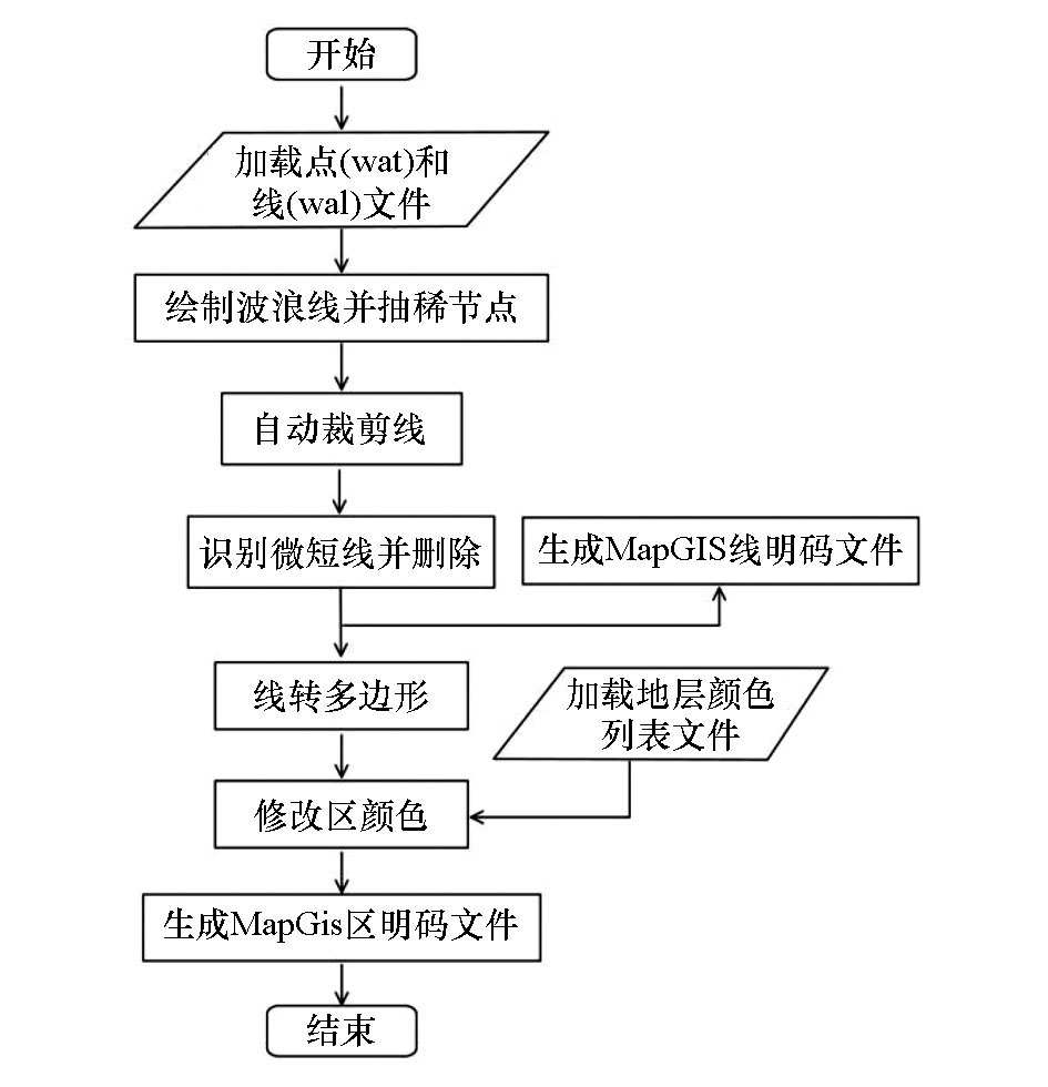
The flow of automatic drawingby programming
|

|
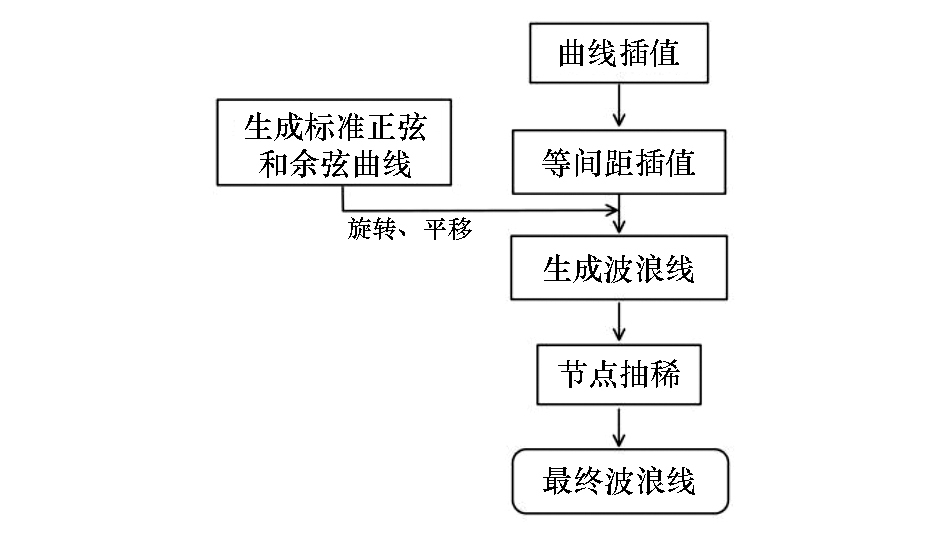
Drawing of wave line
|

| Stratum | geoCode | colorHex | colorGIS | | 第四系 | Q | #ffffdf | 127 | | 上侏罗统满克头鄂博组 | J3mk | #8fffff | 320 | | 下二叠统大石寨组 | P1d | #efcfc7 | 248 | | 下二叠统大石寨组二段 | P1d2 | #ffaf87 | 159 | | 下二叠统大石寨组一段 | P1d1 | #ffbfa3 | 158 | | 角闪斜长花岗岩 | γ | #ff7f7f | 554 | | 花岗斑岩 | γπ | #ff6666 | 556 | | 空(白) | NaN | #ffffff | 264 |
|
Comparison of strata codes and colors
|
|
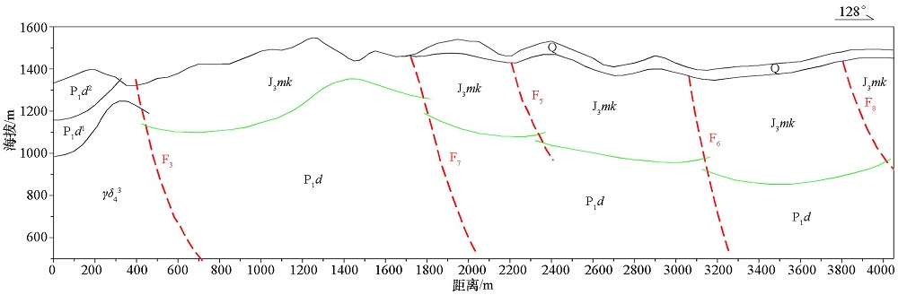
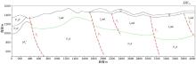
Section of geologic interpretation by manual drawing
|
|
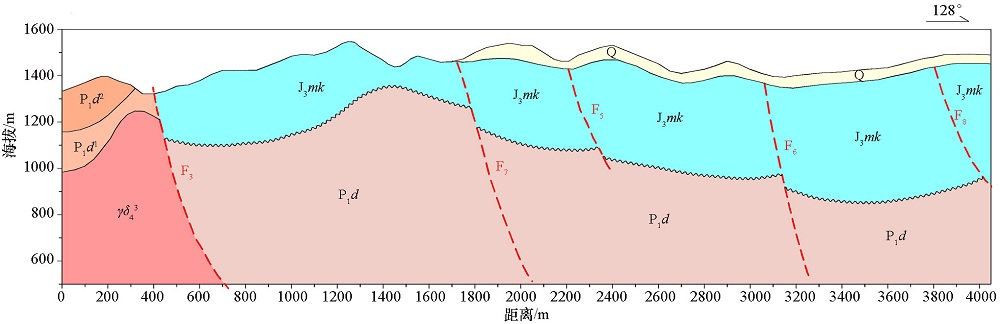
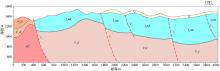
Section of geologic interpretation by automatic drawing (Python)
|
| [1] |
吴金华, 杨瑾. 地图学[M]. 北京: 地质出版社, 2011.
|
| [1] |
Wu J H, Yang J. Cartography[M]. Beijing: Geological Publishing House, 2011.
|
| [2] |
Michael D. Python geospatial analysis cookbook [M]. Birmingham: Packt Publishing Ltd., 2015.
|
| [3] |
Bill L. Introducing Python[M]. Sebastopol: O’Reilly Media Inc., 2014.
|
| [4] |
Erik W. Python geospatial analysis essentials [M]. Birmingham: Packt Publishing Ltd., 2015.
|
| [5] |
Sean G. The shapely user manual (Version 1.7.0) [EB/OL]. https://shapely.readthedos.io/en/latest/,2019.

|
| [6] |
Francisco J B. Mastering SciPy[M]. Birmingham: Packt Publishing Ltd., 2015.
|
| [7] |
Ralf G, Tyler R. SciPy reference guide ( Release 1.4.1) [EB/OL]. The SciPy Community, 2019, http://docs.scipy.org/doc/scipy/reference/,2019.
|
| [8] |
刘华锋, 李庆春, 景月红. 针对剖面平面图的MapGIS应用与开发[J]. 物探与化探, 2009,33(5):587-591.
|
| [8] |
Liu H F, Li Q C, Jing Y H. The application and development of MapGIS for profile map[J]. Geophysical & Geochemical Exploration, 2009,33(5):587-591.
|
| [9] |
吴信才. MAPGIS地理信息系统[M]. 北京: 电子工业出版社, 2004.
|
| [9] |
Wu X C. MapGIS geographic information system[M]. Beijing: Publishing House of Electronics Industry, 2004.
|
| [10] |
李忠权, 刘顺. 构造地质学[M]. 北京: 地质出版社, 2010.
|
| [10] |
Li Z Q, Liu S. Structural geology[M]. Beijing: Geological Publishing House, 2010.
|
|
|
|