|
|
 |
|

|
|
|
Identification and classification of land types of alpine wetlands based on spectral coupling |
NIE Shiyin1( ), LIU Yansong1,2(), LI Huiling1, XUE Kailun1, SHEN Duheng1, HE Boyu2,3 ), LIU Yansong1,2(), LI Huiling1, XUE Kailun1, SHEN Duheng1, HE Boyu2,3 |
1. College of Earth and Planetary Sciences, Chengdu University of Technology, Chengdu 610059, China
2. Key Laboratory of Earth Exploration and Information Technology of Ministry of Education(Chengdu University of Technology), Chengdu 610059, China
3. Sichuan Sumhope Spatial Technology Co., Ltd, Chengdu 610094, China |
|
|
|
|
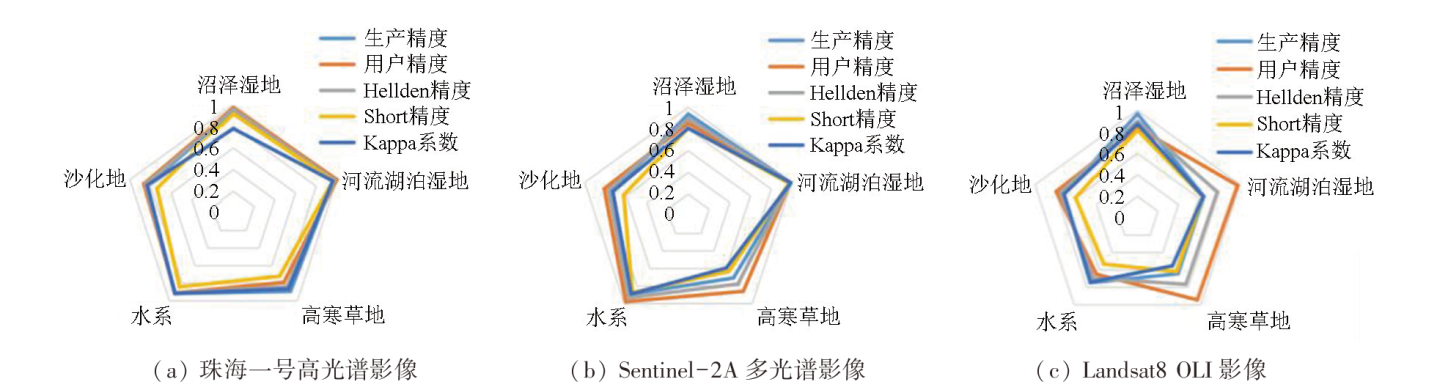
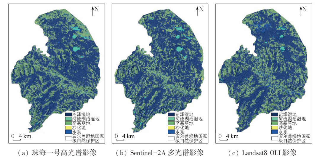
Abstract Alpine wetlands, a critical part of the natural ecosystem in the Qinghai-Tibet Plateau, serve as extremely significant water conservation and climate regulation areas in China. Accurately extracting land cover information of alpine wetlands is crucial for local ecological security monitoring and protection. This study performed object-oriented classification of the data from the Zoige wetland, including the Zhuhai-1 hyperspectral remote sensing image, Sentinel-2A remote sensing image, and Landsat-8 OLI image, integrated with spectral, textural, and topographic features. The results show that the overall data classification accuracy of the three images exceeded 85 %, with a Kappa coefficient above 68 %. The optimal classification result was observed in the Zhuhai-1 hyperspectral remote sensing image. The three images showed generally consistent data classification results, with marsh wetlands being the dominant land type. They indicated roughly the same distribution of riverine and lacustrine wetlands and slightly varying distributions of alpine grasslands, with minor area differences. Additionally, they displayed minimally different distributions of desertified land and almost the same hydrographic net distribution except for slightly different tributary distributions. This study fully explores the combinations of spectral features favorable for image classification, improving the identification accuracy of remote sensing images and providing technical support for the conservation of alpine wetlands.
|
| Keywords
alpine wetland
remote sensing image classification
spectral coupling
feature selection
Zoige
|
|
|
|
Issue Date: 09 May 2025
|
|
|
| [1] |
侯蒙京, 殷建鹏, 葛静, 等. 基于随机森林的高寒湿地地区土地覆盖遥感分类方法[J]. 农业机械学报, 2020, 51(7):220-227.
|
| [1] |
Hou M J, Yin J P, Ge J, et al. Land cover remote sensing classification method of alpine wetland region based on random forest algorithm[J]. Transactions of the Chinese Society for Agricultural Machinery, 2020, 51(7):220-227.
|
| [2] |
郭长庆. 基于多目标遗传算法的若尔盖高原高寒湿地生态修复优化研究[D]. 北京: 北京林业大学, 2021.
|
| [2] |
Guo C Q. Research on ecological restoration optimization of alpine wetland in Zoige Plateau based on multi-objective genetic algorithm[D]. Beijing: Beijing Forestry University, 2021.
|
| [3] |
韦玮, 李增元, 谭炳香. 高光谱遥感技术在湿地研究中的应用[J]. 世界林业研究, 2010, 23(3):18-23.
|
| [3] |
Wei W, Li Z Y, Tan B X. A review of application of hyperspectral remote sensing to wetland study[J]. World Forestry Research, 2010, 23(3):18-23.
|
| [4] |
庞一剑. 基于遥感技术的若尔盖高原湿地生态系统的评价及其监测[D]. 武汉: 武汉大学, 2019.
|
| [4] |
Pang Y J. Evaluation and monitoring of Zoige Plateau wetland ecosystem based on remote sensing technology[D]. Wuhan: Wuhan University, 2019.
|
| [5] |
王利花. 基于遥感技术的若尔盖高原地区湿地生态系统健康评价[D]. 长春: 吉林大学, 2007.
|
| [5] |
Wang L H. Health evaluation of the wetland ecosystem in Zoige Plateau district based on remote sensing[D]. Changchun: Jilin University, 2007.
|
| [6] |
李京, 蒋卫国. 高光谱遥感在湿地监测与分类中的应用[C]// 第十届全国光电技术学术交流会论文集, 2012:152-153.
|
| [6] |
Li J, Jiang W G. Application of hyperspectral remote sensing in wetland monitoring and classification[C]// Proceedings of the 10th National Optoelectronic Technology Academic Exchange Conference, 2012:152-153.
|
| [7] |
王诗洋. 基于多时相遥感影像的辽宁双台河口湿地信息提取研究[D]. 成都: 成都理工大学, 2016.
|
| [7] |
Wang S Y. Extraction of wetlands information using multi-temporal remote sensing images in Shuangtai Estuary area of Liaoning Province[D]. Chengdu: Chengdu University of Technology, 2016.
|
| [8] |
高永攀, 陈书文. 基于遥感影像的湖泊湿地识别研究[J]. 地理空间信息, 2014, 12(5):85-86,10.
|
| [8] |
Gao Y P, Chen S W. Recognition of wetlands based on remote sensing images[J]. Geospatial Information, 2014, 12(5):85-86,10.
|
| [9] |
阮仁宗, 冯学智. 基于多时相遥感和GIS技术的湿地识别研究[J]. 遥感信息, 2005, 20(2):20-23,69.
|
| [9] |
Ruan R Z, Feng X Z. Identification on wetland based on GIS and multi-temporal remote sensing images[J]. Remote Sensing Information, 2005, 20(2):20-23,69.
|
| [10] |
张磊, 宫兆宁, 王启为, 等. Sentinel-2影像多特征优选的黄河三角洲湿地信息提取[J]. 遥感学报, 2019, 23(2):313-326.
|
| [10] |
Zhang L, Gong Z N, Wang Q W, et al. Wetland mapping of Yellow River Delta wetlands based on multi-feature optimization of Sentinel-2 images[J]. Journal of Remote Sensing, 2019, 23(2):313-326.
|
| [11] |
常文涛, 王浩, 宁晓刚, 等. 融合Sentinel-2红边波段和Sentinel-1雷达波段影像的扎龙湿地信息提取[J]. 湿地科学, 2020, 18(1):10-19.
|
| [11] |
Chang W T, Wang H, Ning X G, et al. Extraction of Zhalong wetlands information based on images of Sentinel-2 red-edge bands and Sentinel-1 Radar bands[J]. Wetland Science, 2020, 18(1):10-19.
|
| [12] |
乔雯钰. 基于高光谱遥感影像的黄河入海口湿地分类方法研究[D]. 青岛: 山东科技大学, 2020.
|
| [12] |
Qiao W Y. Research on Yellow River estuary wetland classification based on hyperspectral remote sensing images[D]. Qingdao: Shandong University of Science and Technology, 2020.
|
| [13] |
姚杰鹏, 杨磊库, 陈探, 等. 基于Sentinel-1,2和Landsat8时序影像的鄱阳湖湿地连续变化监测研究[J]. 遥感技术与应用, 2021, 36(4):760-776.
doi: 10.11873/j.issn.1004-0323.2021.4.0760
|
| [13] |
Yao J P, Yang L K, Chen T, et al. Consecutive monitoring of the Poyang Lake wetland by integrating Sentinel-2 with Sentinel-1 and Landsat8 data[J]. Remote Sensing Technology and Application, 2021, 36(4):760-776.
|
| [14] |
张晓斌, 石佳, 欧明武, 等. 基于Landsat8遥感数据的东洞庭湖湿地变化监测与分析[J]. 上海国土资源, 2021, 42(1):24-28.
|
| [14] |
Zhang X B, Shi J, Ou M W, et al. Monitoring and analysis of wetland change in East Dongting Lake based on Landsat8 remote sensing data[J]. Shanghai Land and Resources, 2021, 42(1):24-28.
|
| [15] |
于新菊. 图谱耦合的高分辨率城市精细不透水面提取方法研究[D]. 北京: 中国科学院大学(中国科学院遥感与数字地球研究所), 2016.
|
| [15] |
Yu X J. Fine scale impervious surface extraction method research based on coupled spectral and spatial features[D]. Beijing: University of Chinese Academy of Sciences (Institute of Remote Sensing and Digital Earth Chinese Academy of Sciences), 2016.
|
| [16] |
左丹丹, 罗鹏, 杨浩, 等. 保护地空间邻近效应和保护成效评估——以若尔盖湿地国家级自然保护区为例[J]. 应用与环境生物学报, 2019, 25(4):854-861.
|
| [16] |
Zuo D D, Luo P, Yang H, et al. Assessing the space neighborhood effects and the protection effectiveness of a protected area:A case study from Zoige Wetland National Nature Reserve[J]. Chinese Journal of Applied and Environmental Biology, 2019, 25(4):854-861.
|
| [17] |
费世民, 崔丽娟, 何亚平, 等. 若尔盖高寒湿地生态系统定位站的背景研究——若尔盖高寒湿地研究概述[J]. 四川林业科技, 2006, 27(2):21-29.
|
| [17] |
Fei S M, Cui L J, He Y P, et al. A background study of the wetland ecosystem research station in the Ruoergai Plateau[J]. Journal of Sichuan Forestry Science and Technology, 2006, 27(2):21-29.
|
| [18] |
武高洁, 林海晏, 宁宇, 等. 近12年若尔盖自然保护区各功能区景观格局动态分析[J]. 西部林业科学, 2017, 46(5):6-12.
|
| [18] |
Wu G J, Lin H Y, Ning Y, et al. Landscape pattern dynamic of Zoige Wetland during 12 years based on functional zone division[J]. Journal of West China Forestry Science, 2017, 46(5):6-12.
|
| [19] |
张振勇, 王萍, 朱鲁, 等. eCognition技术在高分辨率遥感影像信息提取中的应用[J]. 国土资源信息化, 2007(2):15-17,33.
|
| [19] |
Zhang Z Y, Wang P, Zhu L, et al. Application of the eCognition technology to information extraction from high resolution remote sensing image[J]. Land and Resources Informatization, 2007(2):15-17,33.
|
| [20] |
郭霞. 基于Landsat8 OLI遥感数据的随机森林分类优化研究[D]. 秦皇岛: 燕山大学, 2021.
|
| [20] |
Guo X. Optimization research of random forest classification based on Landsat8 OLI remote sensing Images[D]. Qinhuangdao: Yanshan University, 2021.
|
| [21] |
郑淑丹, 郑江华, 石明辉, 等. 基于分形和灰度共生矩阵纹理特征的种植型药用植物遥感分类[J]. 遥感学报, 2014, 18(4):868-886.
|
| [21] |
Zheng S D, Zheng J H, Shi M H, et al. Classification of cultivated Chinese medicinal plants based on fractal theory and gray level co-occurrence matrix textures[J]. Journal of Remote Sensing, 2014, 18(4):868-886.
|
| [22] |
陈云浩, 冯通, 史培军, 等. 基于面向对象和规则的遥感影像分类研究[J]. 武汉大学学报(信息科学版), 2006, 31(4):316-320.
|
| [22] |
Chen Y H, Feng T, Shi P J, et al. Classification of remot sensing image based on object oriented and class rules[J]. Geomatics and Information Science of Wuhan University, 2006, 31(4):316-320.
|
|
Viewed |
|
|
|
Full text
|
|
|
|
|
Abstract
|
|
|
|
|
Cited |
|
|
|
|
| |
Shared |
|
|
|
|
| |
Discussed |
|
|
|
|
 2025,
Vol. 37
2025,
Vol. 37