
0 引言
我国每年都进行年度土地利用变更调查,以保证我国土地利用调查数据成果具有很好的现势性。目前的土地利用变化信息获取还是以人工解译遥感影像为主,任务繁重,效率较低。利用计算机自动分类技术快速获得土地利用变化信息已成为当前的迫切需求。
根据变化检测前是否获得土地利用/覆盖的类别信息,可以将变化检测方法分为分类后比较法和直接比较法。直接比较法是直接对同一区域不同时相遥感影像的光谱和其他特征信息进行比较,利用差异信息直接确定变化的位置与范围,常用方法有影像代数法[1]、变化矢量分析法[2,3]、多元变化检测(multivariate alteration detection,MAD)变换法[4]以及光谱梯度差分法[5]等。在这类方法中,除了光谱特征,距离测度[6]、自相关性[7,8]和建筑物指数[9,10,11]等也被广泛使用,在直接比较结果的基础上设置阈值或进行二类分类从而获得变化区域[2-3,12-13]。分类后比较法是先获得前后时相的土地利用/覆盖类别,通过对比前后类别发现变化,常用的方法有基于像元的随机森林分类[14]、贝叶斯分类[15]、马尔科夫随机场集成多特征分类[16,17,18],以及面向对象分类[19,20]等。分类后比较法的关键问题在于分类本身是一个比较繁琐的过程,且易于将分类误差引入变化检测结果并放大。目前也有学者开始研究利用土地利用数据库辅助变化检测,如将后一时相分类结果与土地利用矢量对比发现变化[19,21]、从土地利用数据中学习规则知识[22]等。
尽管这些方法在国内外取得了较好的变化检测效果,但往往过程较复杂,需要人工设置一定的参数或规则,并存在较多的漏提。土地利用变更调查的原则是尽量不遗漏任何疑似变化区域,同时由于作业范围大,要求方法具有一定的自动化程度和较快的运行速度。针对这些需求,本文提出一种基于多源数据的土地利用变化自动检测方法。该方法利用多源数据实现信息互补,将分类后比较法和直接比较法相结合,以提高变化检测的自动化程度、效率和可靠性。
1 研究区概况与数据源
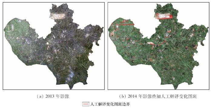
本文研究区选择了我国南方和北方2个生态经济区的典型区域。一个位于黑龙江省杜尔伯特蒙古族自治县,属于东北平原地区。该县近些年来以“畜牧强县”政策为主发展经济,大力发展畜牧业,并且鼓励牧民进城镇生活,出现了大量新增建设用地。研究区域为该县政府驻地的康泰镇及其周围区域,面积约为150 km2。另一个位于湖南省长沙县,属于南方丘陵地区。该县处于长株潭“两型社会”(资源节约型和环境友好型社会)综合配套改革试验区的核心地带,近年大力发展工业、建立物流基地,同样出现大量土地利用变化。区内包括黄兴镇和干杉镇范围,面积约为160 km2。本文使用的数据为国家年度变更调查标准数据,包括前、后2时相的遥感影像,以及前一时相的土地利用数据。同时采用后一时相国家土地利用变更调查中人工解译提取的变化图斑结果作为对比数据,该结果是作业人员在ArcGIS软件中通过目视对比前后时相影像提取的。其中,杜尔伯特蒙古族自治县研究区数据为2012和2013年度的数据,遥感影像是SPOT5影像(空间分辨率为2.5 m); 长沙县研究区数据为2013和2014年度的数据,遥感影像为国产高分卫星影像(空间分辨率为2 m)。所使用的遥感影像均按照国家年度变更调查标准技术规范进行了几何纠正和辐射校正处理,与土地利用数据精确配准。研究区域遥感影像分别如图1和图2所示。
图1
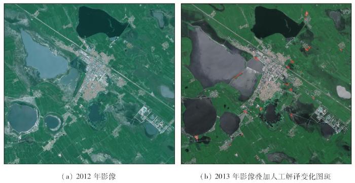
图1
杜尔伯特蒙古族自治县研究区数据
Fig.1
Experiment data in Dorbet Mongolian Autonomous County
图2
2 基于多源数据的土地利用变化检测
本文提出利用多源数据进行自动的土地利用变化检测。首先,利用前一时相的土地利用数据,自动获取后一时相影像上的训练样本,进行影像分类,将后一时相分类结果与前一时相土地利用数据对比,自动地发现变化区域; 然后,对前、后2时相影像做MAD变换,利用MAD变换影像自动设置阈值去除伪变化; 最后,通过目视判别确定提取的疑似变化图斑是否为真实变化,对于真实变化区域采用人工绘制边界方法提取变化图斑。整体技术流程如图3所示。
图3

2.1 矢量数据辅助影像自动分类
影像分类是一个比较繁琐的过程,特征选择、样本提取和分类器参数设置等方面均影响分类结果,对操作人员经验要求较高。本文基于第二次土地利用调查中农村土地利用类别体系建立分类类别体系,研究从已有土地利用矢量数据中自动获得样本的影像全自动分类方法,并在此基础上实现自动的变化检测。
2.1.1 自动分类类别体系设计
年度土地利用变更调查重点监测的是非建设用地到建设用地的变化,包括已建成区域和在建区域,其规定的变化类型与土地利用调查土地分类体系中的类别并不完全对应一致。在内业变化图斑提取过程中,只需要发现变化区域,最重要的需求是不遗漏真正变化区域和提取效率尽可能高,最终的变化后地物类别是通过外业核查确定的。针对这一特点,本文将土地利用调查土地分类体系中的地物类别简化为5大地类进行影像分类,将“耕地”、“园地”、“林地”和“草地”简化为植被类; “交通运输用地”中除“机场用地“和“港口码头用地”外,均简化为道路类; “水域及水利设施用地”中除“水工建筑用地”外,均简化为水体类; “其他土地”中除“设施农用地”外,均简化为裸地类; “城镇村及工矿用地”、“机场用地”、“港口码头用地”、“水工建筑用地”和“设施农用地”合并为建筑物类。
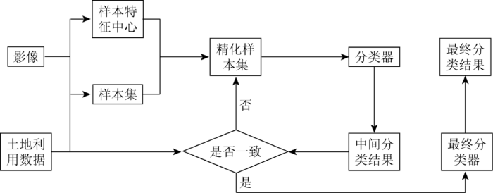
2.1.2 样本的自动选择与精化
样本的选择对分类结果有较大的影响。传统方法中分类样本是通过人工选取的,选取的结果严重依赖于作业员的专业知识和经验,使分类结果受作业员的主观性影响较大。在本文方法中,利用已有土地利用数据自动获得训练样本并精化,从而实现全自动的影像分类,在提高效率的同时保证了分类结果的客观性。
在土地利用变更调查中已有前一时相土地利用矢量数据,尽管后一时相部分区域土地利用会发生变化,但在未发生变化的区域,矢量数据的类别和影像是正确对应的。实际情况中,1 a内变化区域相对只是少数,土地利用数据中图斑的类别信息可认为绝大部分都是准确的。因此,将前一时相土地利用数据中的所有图斑作为初始样本,采用迭代过程剔除少数错误样本,精化初始样本。其步骤为: 首先,计算每个类别的类别特征中心,计算每个样本与各个类别特征中心的特征距离,选择所有特征距离最小类别与土地利用数据类别一致的样本,组成初始的精化样本集; 然后,利用初始的精化样本集训练分类器对每个样本进行分类,对比每一个样本分类类别和在土地利用数据中的类别,将不一致的样本剔除,得到新的精化样本集; 最后,利用新的样本集重新训练分类器,如此循环迭代,直至所有样本的分类类别与土地利用数据中的类别一致,得到最终的精化样本集,并采用训练得到的最终分类器对影像进行分类,得到最终分类结果。方法的基本流程如图4所示。
图4
2.1.3 分类器设计与分类特征计算
支持向量机(support vector machine,SVM)遵循结构风险最小化的原则,具有强大的非线性和高维处理能力及泛化能力,非常适合于遥感影像的分类。大量实验表明,在SVM的各种核函数中,径向基函数(radial basis function,RBF)具有较好的稳定性。因此,本文选择基于RBF的SVM作为影像分类器。通过大量实验,设置RBF的γ参数为2.0,惩罚系数C为1.0。
本文采用的分类特征是影像的光谱特征和光谱特征的归一化四则运算特征。归一化四则运算特征计算方式为
式中:
完成影像分类后,将分类结果与土地利用矢量对比即可获得变化检测结果。土地利用变更调查主要关注非建设用地变化为建设用地。因此,将类别不一致且分类类别为建筑物、道路或裸地的像素标记为变化像素,将相邻的变化像素聚集成疑似变化图斑。尽管在分类过程中不可避免会存在分类误差,但本文方法的主要错误分类是将非建设用地误分为建设用地,因此,变化检测的结果一般不会出现漏提现象,满足变更调查不遗漏变化的要求。另一方面,变化检测结果会存在较多的伪变化,需要进一步去除,本文利用前后时相影像的MAD变换影像来去除伪变化。
2.2 基于MAD变换的伪变化去除
2.2.1 MAD变换原理
MAD变换的基本思想是认为前后时相影像在未变化的区域存在强相关,在变换区域存在弱相关。通过典型相关分析可以分析前后时相影像的整体相关性突出变化区域。
设随机向量
式中:
根据典型相关分析原理,2个新的变量
2.2.2 利用MAD变换去除伪变化
尽管现有研究表明,MAD变换相比于其他正交变换(如主成分分析变换)具有更好的突显变化的能力[4],但当影像覆盖范围大、地物复杂时,MAD影像上变化区域和非变化区域灰度值区间仍然存在一定重叠,设置阈值提取变化区域时,要满足变更调查“不遗漏变化”的要求,会造成较多的误提伪变化。因此,本文并不直接利用MAD影像提取变化区域,而是在自动分类变化检测基础上,利用MAD影像剔除伪变化区域。
大范围检测任务下,影像上变化区域所占比例较小。因此本文通过灰度直方图自动确定阈值,即将直方图中一定百分比对应的灰度值作为阈值,小于阈值的像素被认为是一定没有发生变化的像素,如果一个疑似变化区域所有像素的灰度值均小于阈值,则认为是伪变化区域,将其剔除。另外,高空间分辨率影像上地物局部细节的变化可能会造成细小的伪变化,以及前后时相存在几何配准误差也会造成细小的伪变化,这些伪变化可以通过设置面积阈值滤除。
2.3 变化图斑绘制与提取
实际作业中,一般在伪变化去除后仍然会有一定的伪变化存在。这些伪变化除了来源于分类错误之外,更多的是客观地物与土地利用定义不一致造成的。例如农田由于搭建农业大棚等呈现类似建筑物的特征被误分为建筑物,盐碱地等也会呈现类似建筑物的光谱特征; 而田间的道路由于一般宽度较窄在土地利用分类中仍被归为农田类(旱地、水浇地和水田等)的一部分。这些伪变化很难通过自动方法滤除。因此本文方法采用目视观察剔除这类伪变化,然后通过目视对比确定变化区域的变化类型,最后人工绘制准确的变化图斑边界。
3 实验与分析
采用本文方法对杜尔伯特蒙古族自治县研究区域数据进行处理,结果如图5所示。
图5

图5
杜尔伯特蒙古族自治县数据处理结果
Fig.5
Processing results of experiment data in Dorbet Mongolian Autonomous County
首先将2012年度土地利用数据进行类别简化(图5(a)),然后通过样本精化自动获得训练样本,利用自动训练的分类器对2013年影像进行分类,结果如图5(b)。从图中可以看出,自动分类结果存在一定的误差,主要的误分区域是部分亮水体和道路被误分为建筑物。其中道路和建筑物都属于建设用地,在土地利用变化检测过程中,道路的误分不会造成影响,而水体的误分会造成误提的伪变化,需要通过后续处理去除。另一方面值得注意的是,2013年影像成像时间在雨季,地面积水比较严重,在2012年影像上部分草地和滩涂裸地被水淹没,2013影像的分类结果上表现出较多的水体,这并非真实的变化,而本文变化检测方法中只关注新增建设用地,这一现象不会造成建设用地变化检测的漏提或误提。将分类结果与2012年土地利用结果对比,得到的初步的变化检测结果如图5(c)所示。从图5(c)中可以看出,尽管自动分类存在一定误差,但其错误主要造成伪变化,而不会漏提真实变化区域。初步提取的疑似变化图斑数量较多(23 735个),需要进一步去除伪变化。首先利用变化区域的面积大小去除过小的伪变化。我国的土地利用规范要求平原地区最小图斑面积为600 m2,影像的空间分辨率为2.5 m,因此将面积阈值设为90个像元。然后计算2012年和2013年影像的MAD变换影像,如图5(d)所示。从图中可以看出发生变化的区域在MAD影像上亮度值都相对较高,可以通过设置阈值去除一定的伪变化。如上文所述采用累积直方图确定阈值,本研究中累积直方图比例设为98%。进行伪变化去除后结果如图5(e)所示,去除伪变化后剩余疑似变化图斑减少到512个。剩下的疑似图斑中仍有比较多的伪变化,这些伪变化除水体外,主要是裸露的农田和农田间的道路,如上文所述,大部分伪变化是客观地物与土地利用定义不一致造成的,只能通过目视观察分辨。这些伪变化往往比较集中,可以通过目视观察快速剔除。经过目视判别后,最终提取并绘制变化图斑37个,结果如图5(f)所示。
采用同样的处理流程对长沙县数据进行处理,取得类似的处理结果,该研究区域地物细碎且变化较多,最终提取变化图斑156个,如图6所示。
图6
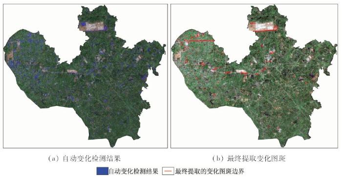
将本文方法提取的结果与国家年度土地利用变更调查结果对比。对于杜尔伯特蒙古族自治县,国家土地利用变更调查共提取了24个变化图斑,本文方法提取了37个变化图斑; 对于长沙县,国家土地利用变更调查共提取了139个变化图斑,本文方法提取了146个变化图斑。相比之下,本文方法能够提取更多的变化图斑,更不易遗漏变化区域。图7示出本文方法与传统方法提取结果的局部对比。
图7

图7
本文方法提取结果与现有方法对比
Fig.7
Comparison of results of the proposed method and traditional method
在实际应用效率方面,本文方法在自动变化检测基础上提取变化图斑,相比于现有目视判读整幅影像的方法能够显著减少工作量,提高作业效率。由于无法得知实际变更调查中研究区域数据的实际作业时间,因此本文设计了对比实验衡量本文方法效率,由相同熟练程度的操作人员按照年度土地利用变更技术规程要求目视解译提取研究区域变换图斑,将其效率与本文方法对比。对于杜尔伯特蒙古族自治县研究区,本文方法所需时间约为23 min,而目视解译作业时间约为50 min; 对于长沙县研究区,本文方法处理所需时间约为70 min,而目视解译作业时间约为2.5 h。与目视判别相比,本文方法所需时间缩短了一半。
4 结语
针对土地利用变更调查提出了一种基于多源数据的土地利用变化检测方法,能够实现自动化、高效率的土地利用变化检测与提取。研究取得如下结论:
1)利用已有前一时相土地利用数据自动获得后一时相影像的训练样本,并通过迭代分类过程自动剔除错误样本,能够实现全自动的影像分类,在提高效率的同时保证了分类结果的客观性; 在此基础上与前一时相土地利用数据对比可以实现全自动的变化检测。
2)对前、后时相影像做MAD变换,利用MAD变换影像可以通过设置简单阈值有效地剔除大部分伪变化区域,提高工作效率。
3)研究证明相比于现有作业方法,本文方法的自动化程度更高,作业速度提高一倍以上,且更不易于遗漏真实变化区域。
4)本文方法的不足之处在于变化图斑的最终提取方面还需要一定的人工干预,需要人工判断变化类型以及绘制变化图斑准确边界,如何进一步提高这方面的自动化程度,是下一步研究的方向。
参考文献
AlKofahi O,et al.Image change detection algorithms:A systematic survey
[J].
DOI:10.1109/TIP.2004.838698
URL
PMID:15762326
[本文引用: 1]

Detecting regions of change in multiple images of the same scene taken at different times is of widespread interest due to a large number of applications in diverse disciplines, including remote sensing, surveillance, medical diagnosis and treatment, civil infrastructure, and underwater sensing. This paper presents a systematic survey of the common processing steps and core decision rules in modern change detection algorithms, including significance and hypothesis testing, predictive models, the shading model, and background modeling. We also discuss important preprocessing methods, approaches to enforcing the consistency of the change mask, and principles for evaluating and comparing the performance of change detection algorithms. It is hoped that our classification of algorithms into a relatively small number of categories will provide useful guidance to the algorithm designer.
A novel approach to unsupervised change detection based on a semisupervised SVM and a similarity measure
[J].
DOI:10.1109/TGRS.2008.916643
URL
[本文引用: 2]
This paper presents a novel approach to unsupervised change detection in multispectral remote-sensing images. The proposed approach aims at extracting the change information by jointly analyzing the spectral channels of multitemporal images in the original feature space without any training data. This is accomplished by using a selective Bayesian thresholding for deriving a pseudotraining set that is necessary for initializing an adequately defined binary semisupervised support vector machine classifier. Starting from these initial seeds, the performs change detection in the original multitemporal feature space by gradually considering unlabeled patterns in the definition of the decision boundary between changed and unchanged pixels according to a semisupervised learning algorithm. This algorithm models the full complexity of the change-detection problem, which is only partially represented from the seed pixels included in the pseudotraining set. The values of the classifier parameters are then defined according to a novel unsupervised model-selection technique based on a similarity measure between change-detection maps obtained with different settings. Experimental results obtained on different multispectral remote-sensing images confirm the effectiveness of the proposed approach.
A novel approach for change detection of remotely sensed images using semi-supervised multiple classifier system
[J].
DOI:10.1016/j.ins.2014.01.037
URL
[本文引用: 2]
In this article, a novel approach using ensemble of semi-supervised classifiers is proposed for change detection in remotely sensed images. Unlike the other traditional methodologies for detection of changes in land-cover, the present work uses a multiple classifier system in semi-supervised (leaning) framework instead of using a single weak classifier. Iterative learning of base classifiers is continued using the selected unlabeled patterns along with a few labeled patterns. Ensemble agreement is utilized for choosing the unlabeled patterns for the next training step. Finally, each of the unlabeled patterns is assigned to a specific class by fusing the outcome of base classifiers using some combination rule. For the present investigation, multilayer perceptron (MLP), elliptical basis function neural network (EBFNN) and fuzzy k-nearest neighbor (k-nn) techniques are used as base classifiers. Experiments are carried out on multi-temporal and multi-spectral images and the results are compared with the change detection techniques using MLP, EBFNN, fuzzy k-nn, unsupervised modified self-organizing feature map and semi-supervised MLP. Results show that the proposed work has an edge over the other state-of-the-art techniques for change detection.
The regularized iteratively reweighted MAD method for change detection in multi-and hyperspectral data
[J].
DOI:10.1109/TIP.2006.888195
URL
PMID:17269639
[本文引用: 2]
This paper describes new extensions to the previously published multivariate alteration detection (MAD) method for change detection in bi-temporal, multi- and hypervariate data such as remote sensing imagery. Much like boosting methods often applied in data mining work, the iteratively reweighted (IR) MAD method in a series of iterations places increasing focus on "difficult" observations, here observations whose change status over time is uncertain. The MAD method is based on the established technique of canonical correlation analysis: for the multivariate data acquired at two points in time and covering the same geographical region, we calculate the canonical variates and subtract them from each other. These orthogonal differences contain maximum information on joint change in all variables (spectral bands). The change detected in this fashion is invariant to separate linear (affine) transformations in the originally measured variables at the two points in time, such as 1) changes in gain and offset in the measuring device used to acquire the data, 2) data normalization or calibration schemes that are linear (affine) in the gray values of the original variables, or 3) orthogonal or other affine transformations, such as principal component (PC) or maximum autocorrelation factor (MAF) transformations. The IR-MAD method first calculates ordinary canonical and original MAD variates. In the following iterations we apply different weights to the observations, large weights being assigned to observations that show little change, i.e., for which the sum of squared, standardized MAD variates is small, and small weights being assigned to observations for which the sum is large. Like the original MAD method, the iterative extension is invariant to linear (affine) transformations of the original variables. To stabilize solutions to the (IR-)MAD problem, some form of regularization may be needed. This is especially useful for work on hyperspectral data. This paper describes ordinary two-set canonical correlation analysis, the MAD transformation, the iterative extension, and three regularization schemes. A simple case with real Landsat Thematic Mapper (TM) data at one point in time and (partly) constructed data at the other point in time that demonstrates the superiority of the iterative scheme over the original MAD method is shown. Also, examples with SPOT High Resolution Visible data from an agricultural region in Kenya, and hyperspectral airborne HyMap data from a small rural area in southeastern Germany are given. The latter case demonstrates the need for regularization
A spectral gradient difference based approach for land cover change detection
[J].
DOI:10.1016/j.isprsjprs.2013.07.009
URL
[本文引用: 1]
Change detection with remotely sensed imagery plays an important role in land cover mapping, process analysis and dynamic information services. Euclidean distance, correlation and other mathematic metrics between spectral curves have been used to calculate change magnitude in most change detection methods. However, many pseudo changes would also be detected because of inter-class spectral variance, which remains a significant challenge for operational remote sensing applications. In general, different land cover types have their own spectral curves characterized by typical spectral values and shapes. These spectral values are widely used for designing change detection algorithms. However, the shape of spectral curves has not yet been fully considered. This paper proposes to use spectral gradient difference (SGD) to quantitatively describe the spectral shapes and the differences in shape between two spectra. Change magnitude calculated in the new spectral gradient space is used to detect the change/no-change areas. Then, a chain model is employed to represent the SGD pattern both qualitatively and quantitatively. Finally, the land cover change types are determined by pattern matching with the knowledgebase of reference SGD patterns. The effectiveness of this SGD-based change detection approach was verified by a simulation experiment and a case study of Landsat data. The results indicated that the SGD-based approach was superior to the traditional methods. (C) 2013 International Society for Photogrammetry and Remote Sensing, Inc. (ISPRS) Published by Elsevier B.V. All rights reserved.
Semi-supervised change detection method for multi-temporal hyperspectral images
[J].
DOI:10.1016/j.neucom.2014.06.024
URL
[本文引用: 1]
Change detection is one of the most important open topics for multi-temporal remote sensing technology to observe the earth. Recently, many methods are proposed to detect the land-cover change information by multi-temporal hyperspectral images. However, many existing traditional change detection methods failed to utilize the spectral information effectively. Hence the models are not robust enough for more widely applications with “noise” bands. In this case, a semi-supervised distance metric learning method is proposed to detect the change areas by abundant spectral information of hyperspectral image under the “noisy” condition. This paper focuses on semi-supervised change detection method, and proposes a new distance metric learning framework for change detection in “noisy” condition with three mainly contributions: (1) Distance metric learning is demonstrated to be an effective method for revealing the change information by high spectral features. (2) An evolution regular framework is utilized to handle change detection under a “noisy” condition without removing any noise bands, which is impacted by atmosphere (or water) and always removed manually in other literatures. (3) A semi-supervised Laplacian Regularized Metric Learning method is exploited to tackle the ill-posed sample problem, and large unlabeled data is exploited in our method. The proposed method is performed on two multi-temporal hyperspectral datasets. Experimental results show that the proposed method outperforms the state-of-the-art change detection methods under both “ideal” and “noisy” conditions.
Land cover change detection using autocorrelation analysis on MODIS time-series data:Detection of new human settlements in the Gauteng Province of South Africa
[J].
DOI:10.1109/JSTARS.2012.2187177
URL
[本文引用: 1]
Human settlement expansion is one of the most pervasive forms of land cover change in the Gauteng province of South Africa. A method for detecting new settlement developments in areas that are typically covered by natural vegetation using 500 m MODIS time-series satellite data is proposed. The method is a per pixel change alarm that uses the temporal autocorrelation to infer a change index which yields a change or no-change decision after thresholding. Simulated change data was generated and used to determine a threshold during an off-line optimization phase. After optimization the method was evaluated on examples of known land cover change in the study area and experimental results indicate a 92% change detection accuracy with a 15% false alarm rate. The method shows good performance when compared to a traditional NDVI differencing method that achieved a 75% change detection accuracy with a 24% false alarm rate for the same study area.
Rapid detection of new and expanding human settlements in the Limpopo Province of South Africa using a spatio-temporal change detection method
[J].
DOI:10.1016/j.jag.2015.04.009
URL
[本文引用: 1]
Recent development has identified the benefits of using hyper-temporal satellite time series data for land cover change detection and classification in South Africa. In particular, the monitoring of human settlement expansion in the Limpopo province is of relevance as it is the one of the most pervasive forms of land-cover change in this province which covers an area of roughly 125000km2. In this paper, a spatio-temporal autocorrelation change detection (STACD) method is developed to improve the performance of a pixel based temporal Autocorrelation change detection (TACD) method previously proposed. The objective is to apply the algorithm to large areas to detect the conversion of natural vegetation to settlement which is then validated by an operator using additional data (such as high resolution imagery). Importantly, as the objective of the method is to indicate areas of potential change to operators for further analysis, a low false alarm rate is required while achieving an acceptable probability of detection. Results indicate that detection accuracies of 70% of new settlement instances are achievable at a false alarm rate of less than 1% with the STACD method, an improvement of up to 17% compared to the original TACD formulation.
Improving the normalized difference built-up index to map urban built-up areas using a semiautomatic segmentation approach
[J].
DOI:10.1080/01431161.2010.481681
URL
[本文引用: 1]
Remote sensing images are useful for monitoring the spatial distribution and growth of urban built-up areas because they can provide timely and synoptic views of urban land cover. Although the normalized difference built-up index (NDBI) is useful to map urban built-up areas, it still has some limitations. This study sought to improve the NDBI by using a semiautomatic segmentation approach. The proposed approach had more than 20% higher overall accuracy than the original method when both were implemented simultaneously at the National Olympic Park (NOP), Beijing, China. One reason for the improvement is that the proposed NDBI approach separates urban areas from barren and bare land to some extent. More importantly, the proposed method eliminates the original assumption that a positive NDBI value should indicate built-up areas and a positive normalized difference vegetation index (NDVI) value should indicate vegetation. The new method has improved universality and lower commission error compared with the original method.
Building change detection from multitemporal high-resolution remotely sensed images based on a morphological building index
[J].
DOI:10.1109/JSTARS.2013.2252423
URL
[本文引用: 1]
In this study, urban building change detection is investigated, considering that buildings are one of the most dynamic structures in urban areas. To this aim, a novel building change detection approach for multitemporal high-resolution images is proposed based on a recently developed morphological building index (MBI), which is able to automatically indicate the presence of buildings from high-resolution images. In the MBI-based change detection framework, the changed building information is decomposed into MBI, spectral, and shape conditions. A variation of the MBI is a basic condition for the indication of changed buildings. Besides, the spectral information is used as a mask since the change of buildings is primarily related to the spectral variation, and the shape condition is then used as a post-filter to remove irregular structures such as noise and road-like narrow objects. The change detection framework is carried out based on a threshold-based processing at both the feature and decision levels. The advantages of the proposed method are that it does not need any training samples and it is capable of reducing human labor, considering the fact that the current building change detection methods are totally reliant on visual interpretation. The proposed method is evaluated with a QuickBird dataset from 2002 and 2005 covering Hongshan District of Wuhan City, China. The experiments show that the proposed change detection algorithms can achieve satisfactory correctness rates (over 80%) with a low level of total errors (less than 10%), and give better results than the supervised change detection using the support vector machine (SVM).
Improved NDBI differencing algorithm for built-up regions change detection from remote-sensing data:An automated approach
[J].
DOI:10.1080/2150704X.2013.763297
URL
[本文引用: 1]
Remote-sensing-based multi-temporal satellite images allow the mapping of changes in built-up areas over time to illustrate the urban development. An improved normalized difference built-up index (NDBI) has recently been promoted as a more effective algorithm to identify built-up regions, compared with the conventional NDBI approach. The conventional NDBI algorithm assumes that difference between the values of the binary NDBI and binary normalized difference vegetation index (NDVI) would indicate built-up areas. The modified NDBI approach improves this assumption by assigning higher positive difference values of continuous NDBI and NDVI to built-up region using an optimal threshold value. This article extends the concept of improved NDBI approach to automate the extraction of built-up changes using multi-temporal satellite images. An automated kernel-based thresholding algorithm is used to sort the difference values of multi-temporal built-up image, obtained from modified improved NDBI differencing algorithm, into built-up and no-built-up change regions for enhancing the efficiency of built-up change detection process. The improved NDBI differencing algorithm better detects built-up change regions than original NDBI differencing algorithm. As a case study, the proposed algorithm has been implemented on Landsat-5 Thematic Mapper (TM) images of a typical Indian city and surrounding areas for built-up change detection.
Unsupervised change-detection methods for remote-sensing images
融合多特征的遥感影像变化检测
[J].
Change detection from multi-temporal remote sensing images by integrating multiple features
[J].
Land use/land cover change detection and prediction in the north-western coastal desert of Egypt using Markov-CA
[J].
DOI:10.1016/j.apgeog.2015.06.015
URL
[本文引用: 1]
61Random forests potential for mapping deserts' LULC using spectral & ancillary data.61Stages of change in LULC of Egyptian northwestern desert due development activities.61Markov-CA approach merit for projecting future land use changes in arid regions.61Understanding changes in LULC can help guide conservation planning in arid regions.
D’Addabbo A,Pasquariello G.A composed supervised/unsupervised approach to improve change detection from remote sensing
[J].
DOI:10.1016/j.patrec.2006.08.010
URL
[本文引用: 1]
In this paper a new approach to performing change detection analyses based on a combination of supervised and unsupervised techniques is presented. Two remotely sensed, independently classified images are compared. The change estimation is performed according to the Post Classification Comparison (PCC) method if the posterior probability values are sufficiently high; otherwise a land cover transition matrix, automatically obtained from data, is used. The proposed technique is compared with the traditional PCC approach. It is shown that the new approach correctly detects the “true change” without overestimating the “false” one, while PCC points out “true change” pixels together with a large number of “false changes”.
A multilayer markovian model for change detection in aerial image pairs with large time differences
Change detection in optical aerial images by a multilayer conditional mixed Markov model
[J].
DOI:10.1109/TGRS.2009.2022633
URL
[本文引用: 1]
In this paper, we propose a probabilistic model for detecting relevant changes in registered aerial image pairs taken with the time differences of several years and in different seasonal conditions. The introduced approach, called the conditional mixed Markov model, is a combination of a mixed Markov model and a conditionally independent random field of signals. The model integrates global intensity statistics with local correlation and contrast features. A global energy optimization process ensures simultaneously optimal local feature selection and smooth observation-consistent segmentation. Validation is given on real aerial image sets provided by the Hungarian Institute of Geodesy, Cartography and Remote Sensing and Google Earth.
Segmentation of remote sensing images using similarity-measure-based fusion-MRF model
[J].
DOI:10.1109/LGRS.2014.2300873
URL
[本文引用: 1]
Classifying segments and detecting changes in terrestrial areas are important and time-consuming efforts for remote sensing image analysis tasks, including comparison and retrieval in repositories containing multitemporal remote image samples for the same area in very different quality and details. We propose a multilayer fusion model for adaptive segmentation and change detection of optical remote sensing image series, where trajectory analysis or direct comparison is not applicable. Our method applies unsupervised or partly supervised clustering on a fused-image series by using cross-layer similarity measure, followed by multilayer Markov random field segmentation. The resulted label map is applied for the automatic training of single layers. After the segmentation of each single layer separately, changes are detected between single label maps. The significant benefit of the proposed method has been numerically validated on remotely sensed image series with ground-truth data.
Integrating remotely sensed data,GIS and expert knowledge to update object-based land use/land cover information
[J].
DOI:10.1080/01431161.2010.536182
URL
[本文引用: 2]
Remote-sensing technology provides a powerful means for land use/land cover (LU/LC) monitoring at global and regional scales. However, it is more efficient and effective to combine remote-sensing measurements with a geographic information system (GIS) database and expert knowledge for change updating than to use remote-sensing technology alone. In this article, these different sources of information are integrated in the proposed framework, which is able to provide rapid updating of LU/LC information. An object-based data analysis is adopted for thematic mapping, taking both spectral and spatial properties into consideration. An expert knowledge coding is introduced and combined quantitatively with other evidence provided by remotely sensed data and the GIS database. A case study using Landsat Thematic Mapper (TM) datasets demonstrated an overall successful LU/LC map updating and a satisfactory change detection using the proposed change-updating framework.
Change detection from remotely sensed images:From pixel-based to object-based approaches
[J].
DOI:10.1016/j.isprsjprs.2013.03.006
URL
[本文引用: 1]
The appetite for up-to-date information about earth's surface is ever increasing, as such information provides a base for a large number of applications, including local, regional and global resources monitoring, land-cover and land-use change monitoring, and environmental studies. The data from remote sensing satellites provide opportunities to acquire information about land at varying resolutions and has been widely used for change detection studies. A large number of change detection methodologies and techniques, utilizing remotely sensed data, have been developed, and newer techniques are still emerging. This paper begins with a discussion of the traditionally pixel-based and (mostly) statistics-oriented change detection techniques which focus mainly on the spectral values and mostly ignore the spatial context. This is succeeded by a review of object-based change detection techniques. Finally there is a brief discussion of spatial data mining techniques in image processing and change detection from remote sensing data. The merits and issues of different techniques are compared. The importance of the exponential increase in the image data volume and multiple sensors and associated challenges on the development of change detection techniques are highlighted. With the wide use of very-high-resolution (VHR) remotely sensed images, object-based methods and data mining techniques may have more potential in change detection. (C) 2013 International Society for Photogrammetry and Remote Sensing, Inc. (ISPRS) Published by Elsevier B.V. All rights reserved.
基于LBP/C纹理的遥感影像居民地变化检测
[J].针对遥感影像上居民地纹理的特点,将基于方差的纹理分析方法、基于LAWS纹理能量测度的纹理分析方法、基于LBP/C(local binary pattern/contrast)的纹理分析方法分别对遥感影像上的居民地纹理特征进行分析描述;然后进行基于区域生长的扩张检测,得到居民地变化检测的结果。对不同地区、不同居民地分布情况的遥感影像进行了居民地扩张变化检测的试验。结果表明,基于LBP/C的变化检测方法可以高精度地检测出居民地的扩张变化,并提高了检测的自动化程度。
Change detection of residential area by remote sensing image based on LBP/C texture
[J].
Automatic change detection of buildings in urban environment from very high spatial resolution images using existing geodatabase and prior knowledge
[J].
DOI:10.1016/j.isprsjprs.2009.10.002
URL
[本文引用: 1]
The updating of geodatabases (GDB) in urban environments is a difficult and expensive task. It may be facilitated by an automatic change detection method. Several methods have been developed for medium and low spatial resolution images. This study proposes a new method for change detection of buildings in urban environments from very high spatial resolution images (VHSR) and using existing digital cartographic data. The proposed methodology is composed of several stages. The existing knowledge on the buildings and the other urban objects are first modelled and saved in a knowledge base. Some change detection rules are defined at this stage. Then, the image is segmented. The parameters of segmentation are computed thanks to the integration between the image and the geodatabase. Thereafter, the segmented image is analyzed using the knowledge base to localize the segments where the change of building is likely to occur. The change detection rules are then applied on these segments to identify the segments that represent the changes of buildings. These changes represent the updates of buildings to be added to the geodatabase. The data used in this research concern the city of Sherbrooke (Quebec, Canada) and the city of Rabat (Morocco). For Sherbrooke, we used an Ikonos image acquired in October 2006 and a GDB at the scale of 1:20,000. For Rabat, a QuickBird image acquired in August 2006 has been used with a GDB at the scale of 1:10,000. The rate of good detection is 90%. The proposed method presents some limitations on the detection of the exact contours of the buildings. It could be improved by including a shape post-analysis of detected buildings. The proposed method could be integrated into a cartographic update process or as a method for the quality assessment of a geodatabase. It could be also be used to identify illegal building work or to monitor urban growth.
