

0 引言
水系提取在地学研究中有很多应用,比如在水系沉积物化探中,需要提取水系网,根据水系网设计采样点; 在遥感蚀变矿物异常提取中,河道中的水体和沉积物会对异常提取产生干扰,需要对水系进行提取和掩模; 同时水系还是遥感构造分析和岩性解译的重要标志[1]。水系提取根据采用的数据可分为基于数字高程模型(digital elevation model,DEM)的和基于遥感影像的,以及二者结合的方法。基于遥感影像的水系提取大多是依据水系中的水体光谱特征,常用方法有单波段阈值法、比值法、波段差值、谱间分析、模式识别和水体指数法等,其中尤以水体指数法最为常用[2,3,4,5,6,7]。但是,在冲沟、处于枯水期的季节性河流以及干涸的河道中,因缺乏水体,水系与裸地等其他地物光谱特征相似,故上述基于水体光谱特征的方法并不适用。因此,对于干涸水系,目前主要通过增强水体特征[5]、监督分类以及利用除水体光谱特征以外的其他特征,如形态特征和地形特征等[8,9,10,11,12,13]进行识别提取。显然,增强水体特征的方法只适合于半干旱的水系; 监督分类方法需要人工选择训练样本,存在主观干预大且耗费人力的缺点; 而基于水体形态特征及地形特征的方法则需要借助DEM等除遥感影像以外的其他数据。
针对以上问题,本文提出基于独立成分分析(independent component analysis,ICA)和形态特征的干涸水系提取方法。ICA是一种线性分解技术,在目标检测中有很好的应用效果[14,15,16,17]。通过优化算法按照统计独立的原则将观测数据分解成若干独立分量,以代表在观测变量上具有不同实际意义的独立信号源。在遥感影像目标检测中,不同地物可以视为不同信号源,它们之间有不同的光谱特征,大多数可以被视为统计独立的实体。因此,通过ICA可以将目标地物和无关地物信号分解到不同分量中,从而分离出目标。利用ICA提取水系的基本思路是通过ICA对包含水系信号的遥感影像进行分离,使得水系独立于其他地物信号,从而识别出水系。ICA是一种非监督方法,不需要选择训练样本,不借助DEM等其他数据,仅利用遥感影像就可进行水系识别,操作简便,能够克服传统方法的诸多不足。
通过ICA提取的水系信息分量图中难免有一些来自于相似地物以及背景的噪声。传统上对于噪声像元通过数学形态学滤波方法[18]进行压制,能够起到一定的作用,但该方法是全局统一尺度的,无法兼顾水系信息的保持和噪声去除,一些较大的噪声图斑无法消除。为了克服这些噪声无法消除的问题,本文提出在数学形态学滤波的基础上再进行基于图斑形态参数的噪声分离。即将经过数学形态学滤波的ICA水系分割二值图像转换为矢量对象,提取每个矢量对象的形态参数,用这些形态参数作为依据进行水系和噪声的分离。
以内蒙古自治区乌拉特后旗获各琦地区为例,应用ICA方法对ASTER影像数据进行线性分解,提取出代表水系信号的独立成分分量,对水系分量进行基于中值滤波的背景抑制,以增强局部信息,减少背景干扰; 然后采用数学形态学滤波进行初步去噪; 再通过将分割结果转换为矢量对象,提取出对象的形态特征,并用这些特征进行基于规则的噪声消除,最终分割出水系。
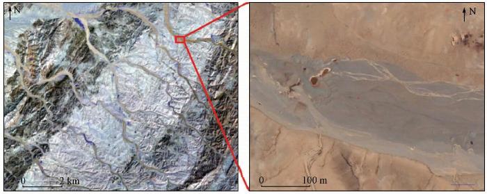
1 研究区概况及数据源
1.1 研究区概况
图1
1.2 数据源
2 研究方法
2.1 独立成分分析
设
以向量形式表示为
式中
ICA理论认为用来观测的混合数据阵x是由独立源
当估计量与源信号最接近时,有
根据式(3)和式(4)可得,
因此,问题求解的思路就是要找到最接近
2.2 水系分量图像增强
通过ICA将数据分解成不同的分量,分别代表对不同独立信号源的近似估计。由于各个分量之间是统计独立的,不同信号源中的信息被集中到不同分量中。对于水系分量来说,水系信息被突出显示,呈现高频特征,而与水系信号在统计上独立性较大的其他信号源的信息在该分量中较少,在图中表现为低频信息,呈现较为连续的低缓背景,即背景值。这些背景值在空间上是有涨落变化的,如果用统一的阈值去分割水系目标和背景,就可能造成错分,导致一些弱的水系信息不能被识别,而一些强的背景信息会被提取为水系。同时,利用ICA分解出的水系分量中可能包含其他与水系信息比较相似的地物信息,会对水系提取造成干扰。综上所述,通过ICA提取的水系分量中可能包含的干扰信号来自于相似信号源和背景信号涨落2方面。对于相似地物造成的干扰较难分离,可以通过后续的基于形态特征的方法进行消除; 对于背景造成的干扰,有很多处理方法,其中基于中值滤波的背景抑制方法是一种常用的方法[26]。该方法的具体做法是: 选择合适大小的窗口进行中值滤波,用滤波值代表每个像元点的局部背景值,将所有像元点的实际灰度值与滤波值相减,得到的值就能很好地降低背景干扰,增强水系信息。
2.3 基于形态特征的图像去噪
将经过局部信息增强的图像用阈值分割方法分割出水系。这种基于像元灰度值分割出来的结果中必然含有一些噪声,传统上可通过数学形态学滤波将这些噪声与水系信息分离[18,27]。但由于数学形态学滤波是全局统一尺度的滤波,无法兼顾水系信息的保持和噪声去除,仍可能会在消除噪声的同时造成细小水系信息的丢失,且当噪声数据较大时无法消除,因此应用效果比较有限。而将分割出的图斑转换为矢量对象后,图斑即具有形态属性,如面积、长宽比和形状等,这些特征可以帮助区别水系信息和噪声。在转换为矢量的对象中,水系对象往往呈连续的长条形大图斑,而噪声往往呈零散的小图斑,提取出这些矢量对象的形态学属性,从这些属性中挑选出能够区别水系和噪声的特征变量,就可以实现两者的分离。对于提取出的矢量对象,可以用单个形态变量找出合适的阈值分割水系,如果没有能够分离水系和噪声的单个变量,则需要用多个形态特征变量进行多阈值分割或多变量监督分类。
2.4 方法流程
本文提出的水系提取方法的操作流程见图2。其中遥感影像预处理、ICA、图像增强、数学形态学滤波以及监督分类用ENVI5.2软件完成,图斑转矢量及其矢量对象特征提取用eCognition9.0和ArcGIS10.3软件完成。
图2

3 结果和讨论
图3
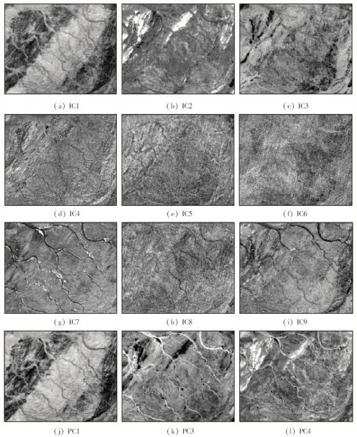
图3
独立成分分量及主成分分量
Fig.3
Independent components obtained using ICA and principle components obtained using PCA
由图3可知,ICA提取的9个独立成分分量中IC7的水系信息最强,所有水系在IC7中都有所显示,水系细节清晰,且其他地物信号的干扰较少。IC7之外的其他分量中干扰信息较多,水系信息较少且都不明显。PCA提取结果显示水系信息分散在多个主成分分量中,而不是主要集中在某一个分量中,且其中非水系信号干扰也较强。
ICA和PCA方法提取水系的结果对比说明,ICA能够将水系信息与其他地物信息分解到不同独立分量中,减少其他地物对水系提取的影响。而PCA不是以分量之间的相互独立为目标的,所以得到的水系信息与其他地物之间独立性差,表现在图上就是在水系分量中存在大量的其他地物信息,与水系信息相互干扰,不利于水系提取。通过与PCA提取结果的对比,可以看出ICA之所以能用于水系提取,关键在于其分解结果是对不同独立信号源的近似估计,独立分量相互之间统计独立,即水系和其他地物之间可视为相互统计独立,因此ICA能够将水系和其他大部分地物分离成相互独立的分量,从而分离出水系。
根据ICA分解结果选择IC7提取水系。IC7中干涸水系集中在图像中较暗的部分,较亮的部分则代表植被。图中水系为高频信息,其余大面积的非水系部分则表现较为连续的低频信息,为背景值。从图中可见,背景值在空间上是有变化的,这种变化会给水系信息的提取带来干扰。除了背景值,还有来自于相似地物的噪声干扰。利用前文提到的背景抑制及去噪方法消除背景及噪声影响,结果见图4。
图4
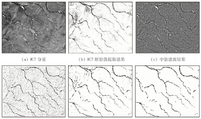
图4
水系分量及不同方法下的去噪结果
Fig.4
Drainage system component and de-noising results with different methods
去背景干扰之后的分割结果与水系的真实分布符合度很高,但仍然有相当数量的错分像元,噪声像元非常多。通过ENVI5.2软件的数学形态学滤波功能,选择不同尺寸的窗口进行各种数学形态学滤波尝试,发现3像元×3像元窗口下进行先膨胀后腐蚀的操作能最好地消除噪声和保留目标信息。图4(e)为数学形态学滤波结果,从图中可见,虽然通过数学形态学滤波消除了一部分较小的噪声,但仍有很多噪声无法消除。对于这部分噪声,本文通过提取形态特征进行消除,即对经过数学形态学滤波的图像,用eCognition9.0软件进行矢量化,提取出矢量对象,通过矢量对象的形态参数进行噪声分离。以图斑为单位进行矢量化,提取出对象的形态参数,具体包括: 面积、长度、宽度、长宽比、形状指数、边界指数、对称度和边界长度。通过观察每个属性的空间变化对于水系分布的响应程度确定出用于分割水系的形态特征集,并经过试验确定出相关变量的阈值,构建水系分类规则,最终分离出水系(图4(f))。从图4(f)可见,噪声大大减少,分割出的水系与实际吻合度很好。
在实际工作中,干涸水系提取更为常用的处理思路是监督分类。通过对比监督分类方法和本文方法的效果来进一步探讨本文方法在水系提取中的表现。通过尝试不同的监督分类方法,本文最终选定效果最好的支持向量机(support vector machine,SVM)算法进行分类和效果比较。SVM算法是一种常用的监督分类方法,在遥感影像分类中应用较多,其原理见文献[28],本文不再赘述。本文SVM模型采用径向基函数(radial basis function,RBF)作为核函数,通过网格搜索[29]选取最佳模型参数,分别为惩罚系数C=25,RBF核参数γ=0.116。根据目视解译分别选择5 000个水系和非水系的标注样本,进行模型训练和分类。分类结果的总分类精度为93.011%,Kappa系数为0.764 6,输出结果见图5(a)。通过3像元×3像元中值滤波进行分类后处理,结果见图5(b)。将监督分类结果与影像叠加(图5(c))进行对比,发现监督分类结果在影像左上部与实际吻合度较差,这主要是因为左上部一些地层(红色圈内)的光谱特征与水系光谱特征极为相似,不容易区分。图5(d)为本文方法提取结果与影像叠加,对比图5(c)和图5(d)发现监督分类对于较细小的水系识别正确率较差,如图中蓝色圈内。监督分类识别出的部分水系连续性差,而且非水系地物被分为水系的情况较严重(如图5(c)中红色圈内)。综上所述,本文方法整体效果好于监督分类方法,且监督分类方法需要选择训练样本数据,受人主观因素以及模型和参数的影响较大; 而本文方法中ICA不需要设置过多参数,也不需要训练样本数据,因此在实际应用中更有优势。
图5
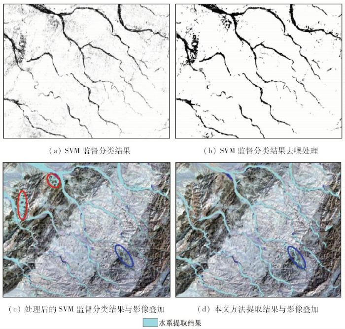
图5
SVM监督分类方法提取水系结果与本文方法提取结果对比
Fig.5
Comparison of drainage system extraction results by SVM supervised classification method and the method proposed in this paper
4 结论
针对干涸水系与裸地等其他地物光谱特征相似,而无法仅利用光谱信息进行干涸水系提取的问题,本文提出了基于ICA和利用形态特征去噪的干涸水系提取方法。对于ICA分离出的水系信息分量,通过中值滤波降低背景干扰,再通过数学形态学滤波和图斑形态特征消除噪声,最终得到精度较高的水系分布。经过对内蒙古自治区获各琦地区的ASTER数据进行实验,验证了该方法的实际效果。本文研究结果表明:
1)通过ICA可以实现水系和大部分非水系地物的分离,提取的水系信息独立分量中水系信息得到增强和突出,其他地物的干扰被大大减少。
2)通过ICA提取的水系分量中存在少量背景干扰和来自于相似地物的干扰,利用基于中值滤波去背景的方法能够降低背景信息干扰,突出局部水系信息。
3)通过将图斑矢量化提取其形态特征,可以提升噪声分离的效果。
4)本文方法能够很好地用于干涸水系信息的提取,相比于传统的监督分类方法识别精度更高,且无需训练样本数据,操作简便,实用性强。
5)本文提出的水系识别方法识别的水系结果是通过与原图进行目视对比,以及通过与大比例尺谷歌地图进行对比验证的,尚缺少实地验证,这是本文存在的不足之处。
参考文献
水系提取方法研究及其地质意义
[D].
The Research of Drainage Extraction Method and Its Geological Significance
[D].
SPOT卫星影像的水体提取方法及分类研究
[J].
DOI:10.3321/j.issn:1007-4619.2001.03.009
URL
[本文引用: 1]

文中分析了水体及其它主要地物的光谱特性在SPOT影像中的表现特征 ,发现大多数地形阴影与水体的光谱特征具有一定的相似性 ,因而用单一的方法很难有效地提取山区中的水体。经过研究 ,发现用决策树分类方法 ,在各节点设计不同的分类器 ,可以有效地提取山区中的水体。由于不同类型的水体其面积、周长、形状等几何特征各有特点 ,并且与地貌类型有一定的关系 ,因而可利用水体的空间特征信息 ,对提取的水体进行分类 ,其方法也选用决策树分类方法 ,分类结果令人满意
Study on water bodies extraction and classification from SPOT image
[J].
水体的遥感信息自动提取方法
[J].
DOI:10.11834/jrs.19980406
URL
[本文引用: 1]
本文在对各种遥感信息提取方法进行深入分析的基础上,提出了一种水体的遥感信息自动提取方法。该方法从遥感信息机理的角度出发,构造地物信息提取模型,并利用面向对象的设计方法建立了该模型,从而实现广义上的基于知识的专题信息提取。以NOAA/AVHRR图像为例进行水体的自动提取,通过对自然水体和新积水区的应用研究,取得了较好的效果。可进一步应用于洪水灾害的监测。
Automatically extracting remote sensing information for water bodies
[J].
利用改进的归一化差异水体指数(MNDWI)提取水体信息的研究
[J].
DOI:10.3321/j.issn:1007-4619.2005.05.012
URL
[本文引用: 1]
在对Mcfeeters提出的归一化差异水体指数(NDWI)分析的基础上,对构成该指数的波长组合进行了修改,提出了改进的归一化差异水体指数MNDWI(Modified NDWI), 并分别将该指数在含不同水体类型的遥感影像进行了实验,大部分获得了比NDWI好的效果,特别是提取城镇范围内的水体.NDWI指数影像因往往混有城镇建筑用地信息而使得提取的水体范围和面积有所扩大.实验还发现MNDWI比NDWI更能够揭示水体微细特征,如悬浮沉积物的分布、水质的变化.另外, MNDWI可以很容易地区分阴影和水体, 解决了水体提取中难于消除阴影的难题.
A study on information extraction of water body with the modified normalized difference water index (MNDWI)
[J].
利用增强型水体指数(EWI)和GIS去噪音技术提取半干旱地区水系信息的研究
[J].
A study on information extraction of water system in semi-arid regions with the enhanced water index(EWI) and GIS based noise remove techniques
[J].
River segmentation using satellite image contextual information and Bayesian classifier
[J].
DOI:10.1080/13682199.2016.1236067
URL
[本文引用: 1]
Satellite-based remote sensing imaging can provide continuous snapshots of the Earth090005s surface over long periods. River extraction from remote sensing images is useful for the comprehensive study of dynamic changes of rivers over large areas. This paper presents a new method of extracting rivers by using training samples based on the mathematical morphology, Bayesian classifier and a dynamic alteration filter. The use of a training map from erosion morphology helps to extract the non-predictive river090005s curves in the image. The algorithm has two phases: creating the profile to separate river area via evaluated morphological erosion and dilation, namely, a training map; and improving the river090005s image segmentation using the Bayesian rule algorithm in which two consecutive filters swipe false positive (non-water area) along the image. The proposed algorithm was tested on the Kuala Terengganu district, Malaysia, an area that includes a river, a bridge, dam and a fair amount of vegetation. The results were compared with two standard methods based on visual perception and on peak signal-to-noise ratio, respectively. The novelty of this approach is the definition of the contextual information filtering technique, which provides an accurate extraction of river segmentation from satellite images.
A novel active contour model based on modified symmetric cross entropy for remote sensing river image segmentation
[J].
DOI:10.1016/j.patcog.2017.02.022
URL
[本文引用: 1]
The traditional active contour models can not segment the remote sensing river images accurately. To solve this problem, a novel active contour model based on modified symmetric cross entropy is proposed. In the proposed model, the external energy constraint terms are defined by the symmetric cross entropy and the region fitting centers are represented by the medians of pixel grayscale values inside the object and background regions. Moreover, the penalty energy term is incorporated into the energy functional to avoid the re-initialization. In order to improve the segmentation efficiency of the proposed model, the Chebyshev distance between the pixel grayscale values inside the region and its region fitting center is chosen as its region energy weight, which can be adaptively adjusted, instead of the constant region energy weight. The extensive experiments are performed on a large number of remote sensing river images and the results demonstrate that, compared with the CV model, the GAC model, the CEACM model, the RSF model, the LIF model, and the LGIF model, the proposed model can segment the images more accurately and rapidly, which has the clear advantages in both segmentation performance and segmentation efficiency.
Remote gully erosion mapping using ASTER data and geomorphologic analysis in the Main Ethiopian Rift
[J].
DOI:10.1007/s11806-011-0565-1
URL
[本文引用: 1]
The Main Ethiopian Rift (MER) is an area of extreme topography underlain by post-Miocene volcanic rocks, Jurassic limestone and a Precambrian basement. A prime concern is the rapid expansion of wide gullies that are impinging on agricultural land. We investigate the potential contribution of Advanced Space-borne Thermal Emission and Reflection Radiometer (ASTER) data and geomorphologic parameters to discern patterns and features of gully erosion in the MER. Maximum Likelihood Classification (MLC), Support Vector Machine (SVM), and Minimum Distance (MD) classifiers are used to extract different gully shapes and patterns. Several spatial textures based on Grey Level Co-occurrence Matrices (GLCMs) are then generated. Afterwards, the same classifiers are applied to the ASTER data combined with the spatial texture information. We used geomorphologic parameters extracted from SRTM and ASTER DEMs to describe the geomorphologic setting and the gullies鈥 shapes. The classifications show accuracies varying between 67% and 89%. Maps derived from this quantitative analysis allow the monitoring and mapping of land degradation as a direct result of gully-widening. This study reveals the utility of combining ASTER data and spatial textural information in discerning areas affected by gully erosion.
Gully Mapping Using Remote Sensing:Case Study in KwaZulu-Natal, South Africa
[D].
The normalized topographic method:An automated procedure for gully mapping using GIS
[J].
DOI:10.1002/esp.3595
URL
[本文引用: 1]
ABSTRACT Gully delineation is a critical aspect of accurately determining soil losses but associated methodologies are rarely detailed. Here, we describe a new gully mapping method, the normalized topographic method (NorToM), based on processing digital elevation model (DEM) data, and we assess associated errors when it is applied over a range of geomorphological scales. The NorToM is underpinned by two gully detection variables (normalized slope and elevation) calculated over local windows of prescribed size, and a group of filtering variables. For four study sites, DEMs of gullies were obtained using field and airborne photo-reconstruction and evaluated using total station and differential global positioning system (dGPS) survey. NorToM provided accurate areal and volume estimates at the individual gully scale but differences increased at the larger gully system and gully network scales. We were able to identify optimal parameters for using the NorToM approach and so confirm that is represents a useful scale-independent means of gully mapping that is likely to be valid in other environments. Its main limitations are that the normalization process might be time-consuming at regional scales and the need for a fixed window size when applied to landforms with extreme variations in dimensions. Copyright 2014 John Wiley & Sons, Ltd.
Gully erosion mapping and monitoring at multiple scales based on multi-source remote sensing data of the Sancha River catchment,Northeast China
[J].
DOI:10.3390/ijgi5110200
URL
[本文引用: 1]
This research is focused on gully erosion mapping and monitoring at multiple spatial scales using multi-source remote sensing data of the Sancha River catchment in Northeast China, where gullies extend over a vast area. A high resolution satellite image (Pleiades 1A, 0.7 m) was used to obtain the spatial distribution of the gullies of the overall basin. Image visual interpretation with field verification was employed to map the geometric gully features and evaluate gully erosion as well as the topographic differentiation characteristics. Unmanned Aerial Vehicle (UAV) remote sensing data and the 3D photo-reconstruction method were employed for detailed gully mapping at a site scale. The results showed that: (1) the sub-meter image showed a strong ability in the recognition of various gully types and obtained satisfactory results, and the topographic factors of elevation, slope and slope aspects exerted significant influence on the gully spatial distribution at the catchment scale; and (2) at a more detailed site scale, UAV imagery combined with 3D photo-reconstruction provided a Digital Surface Model (DSM) and ortho-image at the centimeter level as well as a detailed 3D model. The resulting products revealed the area of agricultural utilization and its shaping by human agricultural activities and water erosion in detail, and also provided the gully volume. The present study indicates that using multi-source remote sensing data, including satellite and UAV imagery simultaneously, results in an effective assessment of gully erosion over multiple spatial scales. The combined approach should be continued to regularly monitor gully erosion to understand the erosion process and its relationship with the environment from a comprehensive perspective.
GIS-based detection of gullies in terrestrial LiDAR data of the Cerro Llamoca peatland (Peru)
[J].DOI:10.3390/rs5115851 URL [本文引用: 1]
Gully erosion mapping using object-based and pixel-based image classification methods
[J].DOI:10.2113/gseegeosci.21.2.101 URL [本文引用: 1]
An assessment of independent component analysis for detection of military targets from hyperspectral images
[J].
DOI:10.1016/j.jag.2011.03.007
URL
[本文引用: 2]
Hyperspectral data acquired over hundreds of narrow contiguous wavelength bands are extremely suitable for target detection due to their high spectral resolution. Though spectral response of every material is expected to be unique, but in practice, it exhibits variations, which is known as spectral variability. Most target detection algorithms depend on spectral modelling using a priori available target spectra In practice, target spectra is, however, seldom available a priori. Independent component analysis (ICA) is a new evolving technique that aims at finding out components which are statistically independent or as independent as possible. The technique therefore has the potential of being used for target detection applications. A assessment of target detection from hyperspectral images using ICA and other algorithms based on spectral modelling may be of immense interest, since ICA does not require a priori target information. The aim of this paper is, thus, to assess the potential of ICA based algorithm vis a vis other prevailing algorithms for military target detection. Four spectral matching algorithms namely Orthogonal Subspace Projection (OSP), Constrained Energy Minimisation (CEM), Spectral Angle Mapper (SAM) and Spectral Correlation Mapper (SCM), and four anomaly detection algorithms namely OSP anomaly detector (OSPAD), Reed iaoli anomaly detector (RXD), Uniform Target Detector (UTD) and a combination of Reed iaoli anomaly detector and Uniform Target Detector (RXD TD) were considered. The experiments were conducted using a set of synthetic and AVIRIS hyperspectral images containing aircrafts as military targets. A comparison of true positive and false positive rates of target detections obtained from ICA and other algorithms plotted on a receiver operating curves (ROC) space indicates the superior performance of the ICA over other algorithms.
Target detection approach for hyperspectral imagery based on independent component analysis and local singularity
基于带参考信号独立分量分析的高光谱图像目标探测
[J].提出了一种用于高光谱图像目标探测的预处理方法, 目的是提高目标光谱的准确性, 进而提高有监督目标探测算法的精度.该方法将实验室或野外获取的目标光谱作为参考信号, 利用带参考信号的独立分量分析方法, 从图像中提取出与参考信号相关性最大的独立分量作为新的目标光谱.仿真和实际高光谱数据的实验结果表明, 所提出的方法能较大提高目标光谱的准确性, 从而较大提高目标探测算法的精度.
Target detection in hyperspectral imagery based on independent component analysis with references
[J].
基于独立分量分析的高光谱图像目标检测算法
[J].
DOI:10.3969/j.issn.1003-0530.2009.12.016
URL
[本文引用: 1]
提出一种基于独立分量分析(ICA)的高光谱图像目标检测算法。首先利用无监督正交子空间投影进行端元提取,并将端元矢量构成矩阵作为快速定点独立分量分析的初始化混合矩阵,解决了独立分量在排序上的随机性;同时采用基于噪声调整的主分量分析(NAPCA)对原始图像数据降维,继而采用初始化后的快速独立分量分析从保留的主分量中依次提取出目标。利用AVIRIS高光谱数据进行实验研究,结果表明提出的算法能够有效地提取图像中的目标信息,其性能优于改进的CEM检测算法。
Target detection algorithm in hyperspectral imagery based on ICA
[J].
数学形态学在图象处理中的应用进展
[J].
DOI:10.3969/j.issn.1000-8152.2001.04.002
URL
[本文引用: 2]
数学形态学是一种非线性滤波方法形态和差运算,即膨胀与腐蚀是数学形态学的基础.数学形态学已由二值形态学、灰度形态学、软数学形态学、模糊形态学发展到模糊软形态学,可用于抑制噪声、特征提取、边缘检测、图象分割、形状识别、纹理分析、图象恢复与重建等图象处理问题,在图象处理领域得到了越来越广泛的应用.本文结合目前的研究进展,对数学形态学的理论研究及其应用进展进行综合性阐述.
The advances of mathematical morphology in image processing
[J].
Improvements in mapping water bodies using ASTER data
[J].
DOI:10.1016/j.ecoinf.2009.09.013
URL
[本文引用: 1]
Coalbed Natural Gas extraction usually results in the production of excess, or product, water, necessitating a strategy for disposal and minimizing landscape and habitat impacts. In the Powder River Basin in Wyoming, product water is either discharged into ephemeral streams or retention/detention ponds. Monitoring these water bodies is important for environmental, habitat, and human health perspectives. This study assessed the benefits of using higher spatial resolution ASTER image, in contrast to more commonly used moderate-resolution Landsat imagery, for detecting smaller water bodies in the Powder River Basin. ASTER and Landsat Thematic Mapper (TM) images were acquired concomitantly and classified following similar methods to identify water bodies for three color classes and a range of sizes. Results showed that the ASTER image had significantly higher accuracies for detecting clear and green colored water bodies, but did not demonstrate significant improvement for detecting turbid water bodies. ASTER also showed significant improvements in detecting small-scale water bodies. However this improved performance was somewhat offset due to the misclassification of other landscape elements as water in the ASTER image. Overall when compared to Landsat TM image, ASTER image more accurately detected more water bodies, especially those with a relatively small surface area, with the two images producing similar results at large scales. The application of ASTER is therefore appropriate for monitoring and evaluation of water bodies in the Powder River Basin and elsewhere.
ASTER数据在寒区流域水系参数化中的应用——以木扎尔特流域为例
[J].
DOI:10.3321/j.issn:1000-1964.2005.05.024
URL
[本文引用: 1]
介绍了以ASTER遥感数据为信息源,通过遥感图像处理技术自动提取天山南麓木扎尔特流域的DEM.根据已建立的数字高程模型,在A rc/Info模块支持下,自动提取流域水系的参数,如栅格水系流向、自动生成河网等,并探讨了寒区流域水系的参数化过程.结果表明,部分冰川覆盖的槽谷地形(U形)区被误判为流域水系,其误差率为21.1%;经过剔除冰川覆盖区误判以后的水系再与来自1¨100 000地形图的水系长度相比,误差仅为0.9%;另外,由于两者数据源的获取时间不同,河流位置也略有差异,这可能与河道的摆动或改道相关,但来自ASTER影像提取水系更能反映河道的近期信息.总体上讲,ASTER数据能适合寒区流域水系参数化的需要,为水文定量化研究及应用提供数据基础.
Application of ASTER data in parameterizing water system in cold region:Case study for Muzaerte valley
[J].
Independent component analysis:Algorithms and applications
[J].DOI:10.1016/S0893-6080(00)00026-5 URL [本文引用: 1]
Comparative assessment of independent component analysis (ICA) for face recognition
ICA by PCA approach:Relating higher-order statistics to second-order moments
基于独立分量分析特征提取方法的研究及其应用
[D].
Reserch of Feature Extraction Based on Independent Component Analysis and Its Application
[D].
独立成分分析方法综述
[J].
Independent component analysis:A survey
[J].
基于局部自适应中值滤波的红外背景抑制方法
[J].
Algorithm of suppressing infrared background baseing on local self-adaptive median filter
[J].
利用数学形态学的遥感影像水系提取方法
[J].A mathematical morphology based drainage line extraction method from remote sensing image is proposed.The coarse drainage line is first extracted with spectral pattern recognition approach,and then is subject to processes such as drainage line connection,noise removal and drainage line thinning using mathematical morphology transformations.A subset of landsat ETM+ image is used to test the presented method.The result shows that this method can effectively extract continuous and smooth drainage lines.Further comparison is made between the extracted drainage lines and that of the digital line graph(DLG) with reference of remote sensing image.It demonstrated that the drainage lines by the proposed method are better agreed with the image than that of DLG.
Mathematical morphology based drainage line extraction from remote sensing image
[J].
The Nature of Statistical Learning Theory
[M].
