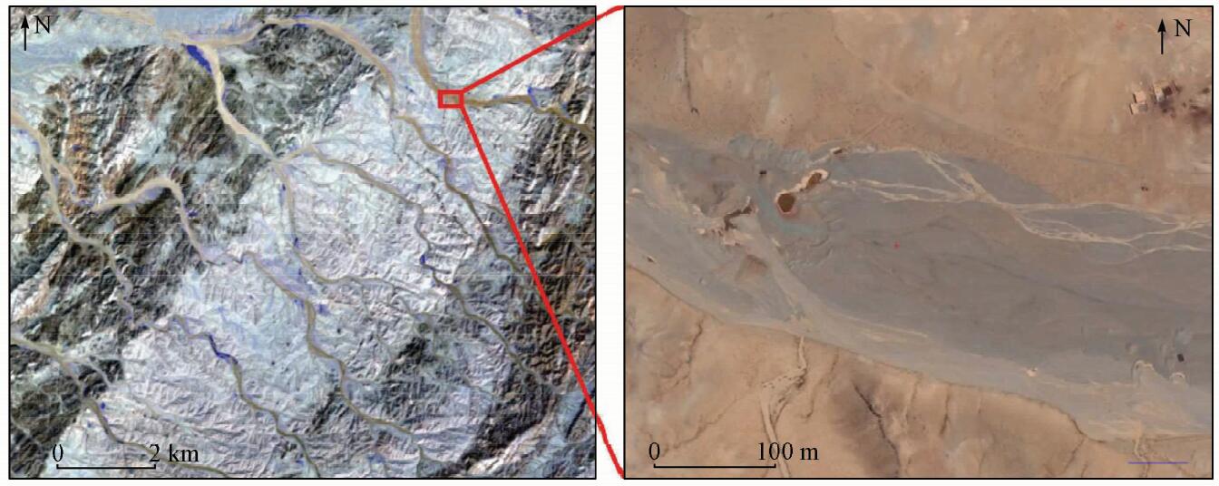
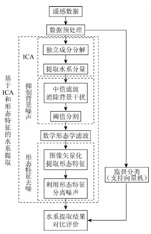
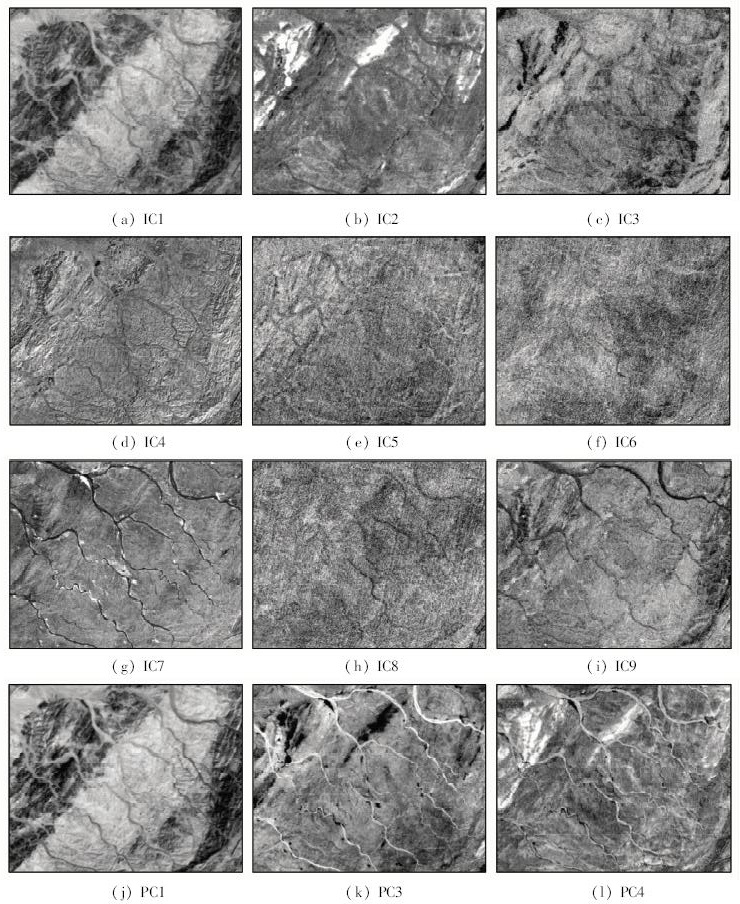
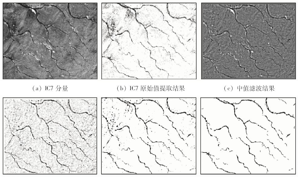
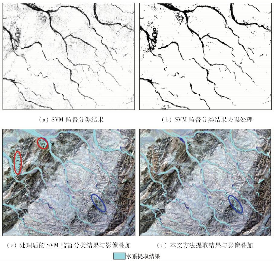
The extraction of drainage system is necessary in many geoscience research fields. For instance, drainage system is an important indicator for structure and lithologic interpretation, sample sites in stream sediment geochemical exploration are designed according to drainage system, and drainage system needs to be recognized and masked in mineral alteration extraction. The drainage system in remote sensing image is generally extracted according to spectral features of water body. However, in the dry drainage systems, such as gullies and seasonal rivers in dry season and under prolonged dry condition, the method based on water body is not applicable. To tackle this problem, the authors propose a method based on independent component analysis (ICA). ICA is a signal decomposition technique that converts multispectral data to independent components which represent independent signal sources, thereby enhancing and separating the specific target in the image. The streambed system extracted by ICA may be still accompanied by noisy data. A series of methods are used to enhance image and remove noise, which include background suppression, morphological filtering and de-noising based on morphological features. The proposed method was tested with ASTER data from Huogeqi area of Urad Rear Banner in Inner Mongolia Autonomous Region, and the result was compared with that derived from supervised classification. The results indicate that the method proposed in this paper can be used to identify dry drainage system, and the recognition result is better than the traditional supervised classification method. The method put forward by the authors performs better in interference information reduction and de-noising, and training data are not needed in this method. In conclusion, the method proposed in this paper is ideal and practical in the extraction of dry drainage system.
陈军林, 彭润民, 闫岩, 赵伟光. 基于独立成分分析和形态特征的干涸水系提取[J]. 国土资源遥感, 2018, 30(4): 163-170.
Junlin CHEN, Runmin PENG, Yan YAN, Weiguang ZHAO. Extraction of dry drainage system based on independent component analysis and morphological characteristics. Remote Sensing for Land & Resources, 2018, 30(4): 163-170.
Du J K, Huang Y S, Feng X Z , et al. Study on water bodies extraction and classification from SPOT image[J]. Journal of Remote Sensing, 2001,5(3):214-219.
Xu H Q . A study on information extraction of water body with the modified normalized difference water index (MNDWI)[J]. Journal of Remote Sensing, 2005,9(5):589-595.
Yan P, Zhang Y J, Zhang Y . A study on information extraction of water system in semi-arid regions with the enhanced water index(EWI) and GIS based noise remove techniques[J]. Remote Sensing Information, 2007,( 6):62-67.
[6]
Yousefi P, Jalab H A, Ibrahim R W , et al. River segmentation using satellite image contextual information and Bayesian classifier[J]. The Imaging Science Journal, 2016,64(8):453-459.
doi: 10.1080/13682199.2016.1236067
[7]
Han B, Wu Y Q . A novel active contour model based on modified symmetric cross entropy for remote sensing river image segmentation[J]. Pattern Recognition, 2017,67:396-409.
doi: 10.1016/j.patcog.2017.02.022
[8]
Bouaziz M, Wijaya A, Gloaguen R . Remote gully erosion mapping using ASTER data and geomorphologic analysis in the Main Ethiopian Rift[J]. Geo-spatial Information Science, 2011,14(4):246-254.
doi: 10.1007/s11806-011-0565-1
[9]
Taruvinga K . Gully Mapping Using Remote Sensing:Case Study in KwaZulu-Natal, South Africa[D]. Waterloo:University of Waterloo, 2009.
[10]
Castillo C, Taguas E V, Zarco-Tejada P , et al. The normalized topographic method:An automated procedure for gully mapping using GIS[J]. Earth Surface Processes and Landforms, 2015,39(15):2002-2015.
doi: 10.1002/esp.3595
[11]
Wang R H, Zhang S W, Pu L M , et al. Gully erosion mapping and monitoring at multiple scales based on multi-source remote sensing data of the Sancha River catchment,Northeast China[J]. ISPRS International Journal of Geo-Information, 2016,5(11):200.
doi: 10.3390/ijgi5110200
[12]
Höfle B, Griesbaum L, Forbriger M . GIS-based detection of gullies in terrestrial LiDAR data of the Cerro Llamoca peatland (Peru)[J]. Remote Sensing, 2013,5(11):5851-5870.
doi: 10.3390/rs5115851
[13]
Karami A, Khoorani A, Nuhegar A , et al. Gully erosion mapping using object-based and pixel-based image classification methods[J]. Environmental and Engineering Geoscience, 2015,21(2):101-110.
doi: 10.2113/gseegeosci.21.2.101
[14]
Tiwari K C, Arora M K, Singh D . An assessment of independent component analysis for detection of military targets from hyperspectral images[J]. International Journal of Applied Earth Observation and Geoinformation, 2011,13(5):730-740.
doi: 10.1016/j.jag.2011.03.007
[15]
Zhang J P, Zhu F Y. Target detection approach for hyperspectral imagery based on independent component analysis and local singularity [C]//International Conference on Natural Computation.Tianjin:IEEE, 2009: 603-607.
Jin S, Wang B, Xia W . Target detection in hyperspectral imagery based on independent component analysis with references[J]. Journal of Infrared and Millimeter Waves, 2015,34(2):177-183.
Dai Q Y, Yu Y L . The advances of mathematical morphology in image processing[J]. Control Theory and Applications, 2001,18(4):478-482.
[19]
Sivanpillai R, Miller S N . Improvements in mapping water bodies using ASTER data[J]. Ecological Informatics, 2010,5(1):73-78.
doi: 10.1016/j.ecoinf.2009.09.013
Zhang Q F, Shangguan D H, Liu S Y , et al. Application of ASTER data in parameterizing water system in cold region:Case study for Muzaerte valley[J]. Journal of China University of Mining and Technology, 2005,34(5):655-659.
[21]
Hyvärinen A, Oja E . Independent component analysis:Algorithms and applications[J]. Neural Networks, 2000,13(4-5):411-430.
doi: 10.1016/S0893-6080(00)00026-5
[22]
Liu C J, Wechsler H. Comparative assessment of independent component analysis (ICA) for face recognition [C]//International Conference on Audio and Video Based Biometric Person Authentication.Washington D.C., 1999: 22-24.
[23]
Zhang K, Chan L W. ICA by PCA approach:Relating higher-order statistics to second-order moments [C]// International Conference on Independent Component Analysis and Signal Separation. Berlin:Springer, 2006: 311-318.
[24]
谢亮 . 基于独立分量分析特征提取方法的研究及其应用[D]. 金华:浙江师范大学, 2009.
Xie L . Reserch of Feature Extraction Based on Independent Component Analysis and Its Application[D]. Jinhua:Zhejiang Normal University, 2009.
Jin A L, Wang Y Z . Algorithm of suppressing infrared background baseing on local self-adaptive median filter[J]. Infrared Technology, 2007,29(8):452-454.
Li H, Dai Z Y, Zhang L H , et al. Mathematical morphology based drainage line extraction from remote sensing image[J]. Geomatics and Information Science of Wuhan University, 2011,36(8):956-959.
[28]
Vapnik V N . The Nature of Statistical Learning Theory[M]. Springer Science and Business Media, 2013.
 2018, Vol. 30
  ), 闫岩, 赵伟光