
0 引言
随着遥感技术的不断发展,高空间分辨率遥感影像层出不穷。面向对象的影像分割方法已成为高空间分辨率影像信息提取的重要手段。但是,目前面向对象的影像分割大多设定一个统一的分割尺度,对不同面积的地物易造成“过分割”和“欠分割”问题[1]。多尺度分割方法可以获得更全面的地物目标特征,逐渐成为研究热点。
针对多尺度分割最优尺度的选取,除依靠经验并结合目视选择最优分割尺度外,一些学者在通过统计计算确定最优尺度方面也开展了许多工作。Espindola等[2]利用影像对象的光谱标准差和Moran’s I指数,构建优度函数进行最优尺度选取; Woodcock等[3]利用对象的均值方差选取最优尺度,认为当影像分割对象的均值方差达到最大时,影像层中的纯对象最多,其所对应的分割尺度最优,但当存在过分割时均值方差也可能很大; 张俊等[4]提出用对象标准差和对象与邻域均值差分绝对值作为指标,构建函数模型选取最优分割尺度; 黄慧萍等[5]运用统计学方法,确定最大面积与分割尺度的关系,结合目视确定不同地物的最优分割尺度。目前已有的最优分割尺度选取方法大多数采用方差或标准差作为对象内部同质性的指标,只考虑对象的光谱统计特性,对于对象的空间分布特性考虑不足[6],没有充分利用高空间分辨率影像的特征,且方差和标准差不能很好地评价对象的同质性[7]; 用Moran’s I指数作为异质性指标,整个分割结果只得到一个异质性指数,忽略了局部对象与对象之间的异质性,具有一定的片面性[8]。
高空间分辨率影像具有更丰富的地物结构与形状信息以及更清晰的纹理特征[5]。已有研究表明,将纹理特征应用于高空间分辨率影像分割以及分类中可以显著提高分割效果和分类精度。Coburn等[9]将本湖影像的纹理信息参与分割和分类,林分的提取效果得到很大改善,分类精度最高提高了40%; Kim等[10]对超高分辨率影像进行面向对象分析,对比了单尺度与多尺度分割结果以及有无纹理特征对分割及分类结果的影响,结果表明辅助纹理特征角二阶矩阵和信息熵等的多尺度分割总精度比单尺度高6%,阐明了纹理的重要性; 林雪等[11]利用GF-1影像的多尺度纹理特征进行面向对象分类,表明结合纹理特征能更有效地提取地物信息,且纹理特征中的均值、协同性和信息熵等均能提高分割效果和分类精度。目前,应用纹理特征进行影像分割和分类较多,但在最优分割尺度选取方面应用信息熵和角二阶矩阵等灰度共生矩阵特征的较少。
针对上述情况,本研究提出用对象的纹理信息熵评价对象内部同质性,用与邻域均值差分绝对值评价对象之间的异质性,简称RMNE(the ratio of mean difference to neighbors(Abs)to entropy)方法,以2016年北京市位于城市边缘的研究区为例,基于6 m空间分辨率的SPOT6影像,采用面向对象的多尺度分割方法,利用RMNE方法选取最优分割尺度,并验证该方法的有效性。
1 研究方法
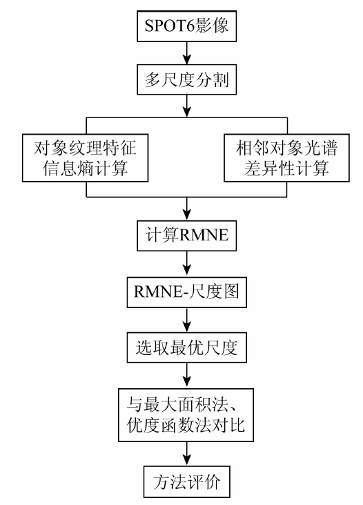
最优分割尺度指的是分割后影像对象与地物目标轮廓相当,大小接近,对象多边形既不能太破碎,也不能边界模糊,且光谱变异情况较小,影像对象内部同质性尽量高,不同类别对象之间的异质性尽量大。本研究依据此原则,利用纹理特征信息熵评价对象内部一致性,光谱特征与邻域均值差分绝对值评价对象外部差异性,构造RMNE指标进行最优分割尺度选取。通过多尺度的RMNE变化曲线确定最优尺度,并与目前常用的最大面积法和优度函数法对比,评价RMNE方法的有效性。基于RMNE方法的多尺度分割最优分割尺度选取流程如图1所示。
图1
1.1 多尺度分割
多尺度分割算法的目标是在指定的与感兴趣的地物目标或空间结构特征相对应的尺度下,将影像分割成高同质的、互相连接的不同影像区域,与感兴趣的地物目标或空间结构特征相对应[12]。本研究运用eCognition8.7平台的多尺度分割技术,从像元开始,采用区域合并方法形成尺度(面积)不等的对象。相邻影像区域两两合并增长,合并的判断依据由相邻对象的异质性表达式值即阈值来决定。阈值可以看作是尺度参数[13]。该尺度参数的选取决定了图像分割停止的条件。若尺度参数过小,容易产生过分割现象,使同一地物被分割成多个对象; 而尺度过大,则容易产生欠分割现象,因此,分割尺度参数的选取成为影响图像分类精度的重要因子[14]。
1.2 RMNE计算及最优分割尺度选取
1.2.1 对象内部纹理信息熵
式中: ENT为对象纹理信息熵值; P(i,j)为灰度共生矩阵中第i行第j列处的概率值; N为灰度共生矩阵的行列数。
计算每一影像对象层的对象信息熵的平均值,作为该层的同质性指数,以此得到所有影像对象层的同质性指数。
为了消除量纲影响,将所得不同影像对象层的信息熵平均值进行归一化处理,取值范围为[0,1],即
式中: ENTmax和ENTmin分别为不同分割尺度对象层的信息熵平均值的最大值和最小值; F(ENT)为对象信息熵归一化后的值,F(ENT)越接近1,表示对象内部分布越复杂,即对象同质性越低; F(ENT)越接近0,表示对象内部分布越均一,即对象同质性越高。
1.2.2 对象之间异质性指数
对象与邻域均值差分绝对值可以揭示对象与每个分割层相邻影像对象的离散情况,由对象的光谱特征计算得到,计算公式为
式中: ΔCL为L波段单个尺度分割对象光谱均值与邻域光谱均值差分的绝对值; B为当前对象的边界长度; m为与目标对象直接相邻的对象个数; Bi为当前对象和第i个直接相邻对象的公共边界长度;
计算每一影像对象层的对象ΔCL平均值,作为该层影像对象层的异质性指数,以此得到所有影像对象层的异质性指数。
已有研究表明该指数可以很好地揭示对象与对象之间的异质性[7]。为了消除量纲影响,同样将所得不同影像对象层的ΔCL平均值进行归一化处理,取值范围为[0,1],计算公式为
式中: ΔCLmax和ΔCLmin分别为不同分割尺度对象层的对象与邻域均值差分绝对值的平均值的最大值和最小值; F(ΔCL)为对象与邻域均值差分绝对值归一化后的值。F(ΔCL)越接近1,表示相邻对象之间越离散,即对象之间异质性越高; F(ΔCL)越接近0,表示相邻对象之间越依赖,即对象异质性越低。
1.2.3 RMNE
基于最优分割尺度原则,采用基于纹理的信息熵来评价对象内部同质性,与邻域均值差分绝对值来评价对象之间的异质性,由于合适的分割参数选择应该是结合了低的信息熵(即对象内部同质好)和高的与邻域均值差分绝对值(即对象之间异质性好),故本文将上述2个归一化后的值相除构建分割评价函数RMNE,计算公式为
RMNE值越大,代表该尺度得到的对象内部具有越高的同质性,对象之间具有越高的异质性。
1.2.4 最优分割尺度选取
在分割实验中,当分割尺度小于某种地物类别目标时,对象内含有相同的地物类别,对象信息熵较小,相邻对象之间属于同一个类别,从而具有空间相关性,离散程度较小,对象与邻域均值差分绝对值较小,故RMNE值较小; 当分割尺度大小等于某种类别目标时,对象内含有相同的地物类别,F(ENT)最小,相邻对象属于不同的类别目标,离散程度最大,F(ΔCL)最大,故RMNE值最大; 当分割尺度进一步增大时,对象内都会含有不同的地物类别,F(ENT)增大,与相邻对象之间的离散程度开始逐渐降低,F(ΔCL)减小,故RMNE值也开始减小。
综上,随着分割尺度的变化,RMNE值呈现由小到大再变小的波动过程,故多尺度分割的RMNE变化曲线的极值所对应的尺度就是最优分割尺度。因此,影像分割的最优尺度可以通过影像对象的RMNE值曲线来选择,结合目视判读或参考数据即可确定不同地物的最优分割尺度。
2 研究区概况及数据源
选取北京市朝阳区与顺义区交界处一地类丰富的地区为研究区,以检验本文方法的有效性(图2)。研究区内包含部分顺义中央别墅区、商业中心、道路、水体、草地和耕地等地物类型,总面积为90.63 km2。实验数据为2016年5月16日获取的6 m空间分辨率的SPOT6多光谱影像,含有蓝光(B)、绿光(G)、红光(R)和近红外(NIR)4个波段; 选择2016年6月14日的Google Earth影像作为实际地物参考影像。
图2
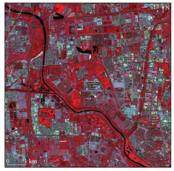
图2
研究区影像
(SPOT6 NIR(R),R(G),G(B)假彩色合成)
Fig.2
Remote sensing image of the study area
3 实验与结果
3.1 分割参数设置
在本研究中,将预处理(包括辐射校正、大气校正等)后的SPOT6影像的4个波段作为图像分割的输入波段,考虑到每个波段的信息都很丰富,所以将4个波段的权重都赋为1。根据经验,将实验中的光谱因子和形状因子权重分别设为0.7和0.3,紧致度因子和光滑度权重都设为0.5。在预实验分割中,当eCognition8.7软件分割尺度参数设置为100时,整个研究区仅被分割为29个对象,对象内部混杂,对象之间无明显边界,这样的对象已不具备研究意义,所以本文将分割尺度参数上限设置为100。选择分割尺度从10增至100,以10为步长的一系列尺度参数对研究区进行预分割,计算分割后每个尺度下的RMNE值,进而选取最优分割尺度。
3.2 RMNE计算结果及最优分割尺度选取
基于多尺度分割技术得到的不同尺度的影像对象,根据1.2节方法计算不同尺度的纹理信息熵值、与邻域均值差分绝对值和RMNE值,结果分别如图3所示。
图3
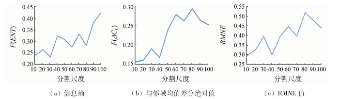
由图3(a)可知,随着分割尺度的增大,对象信息熵值呈现3段先增大再减小的波动上升趋势,在分割尺度分别为30,60和80处形成3个极小值,当分割尺度大于80时F(ENT)急剧上升; 由图3(b)可知,随着分割尺度的增大,对象与邻域均值差分绝对值也呈现3段先增大再减小的波动趋势,当分割尺度分别为30,60和80时,对象与邻域均值差分绝对值出现了3个极大值点,当分割尺度大于80时F(ΔCL)迅速减小; 由图3(c)可知,随着分割尺度与地物类别目标大小之间的变化, RMNE值同样呈现先增大再减小的波动趋势,形成3个极大值点,对应的尺度分别为30,60和80。所以,由最优分割尺度选取方法及图3(c)可知,最优分割尺度组合为30,60和80。结合目视判断,尺度为30时,水体、道路、部分草地和水边林地的边界清晰,且能与其他相邻地物区分开,但大面积的耕地、建筑用地被分割的过于破碎; 尺度为60时,部分草地、建筑用地、耕地以及林地边界完整清晰,光谱差异较为显著; 尺度为80时,大面积的建筑用地和耕地具有完整的形状和边界,且容易与周围地物区分开。
3.3 方法比较
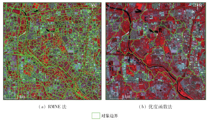
图4
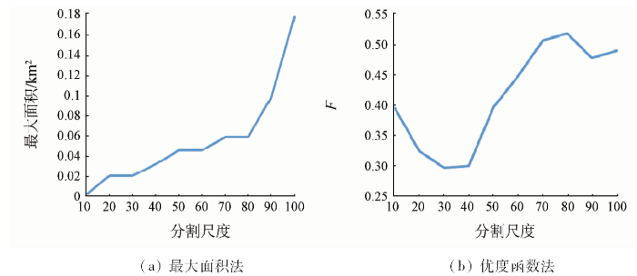
图4
最大面积法和优度函数法结果
Fig.4
Results of maximum area method and objective function method
由图4(a)可知,最大面积法得到的最优尺度区间分别为[20,30],[50,60]和[70,80],RMNE方法得到的最优分割尺度分别为30,60和80,处于上述尺度区间内,表明用RMNE方法获取最优分割尺度是有效的。而且相比最大面积法,RMNE法可以确定一个明确的尺度,更有利于后续实验。为了表明加入灰度共生矩阵的信息熵特征更有利于对高空间分辨率影像进行最优分割尺度选择,本文又将RMNE法得到的结果与优度函数法得到的结果进行对比,由图4(b)可以看出,优度函数法得到的最优分割尺度只有80。所以,仅用光谱特征来构建优度函数选取最优分割尺度对高空间分辨率影像来说具有一定的局限性,而加入了纹理特征,可以更好地选取最优分割尺度。通过与上述方法的对比分析可以发现,RMNE方法可以更好地选取多尺度分割的最优分割尺度。
3.4 多尺度分割结果及评价
图5
为了对比RMNE方法和最大面积法的分割结果,取最大面积法得到的3个最优分割尺度区间的中值(25,55和75)进行多尺度分割。随机选取2种方法分割得到的4块不同地物类型(别墅、城镇居民地、商业用地和耕地)的影像对象进行对比,并以Google Earth影像作为参考,结果如图6所示。
图6
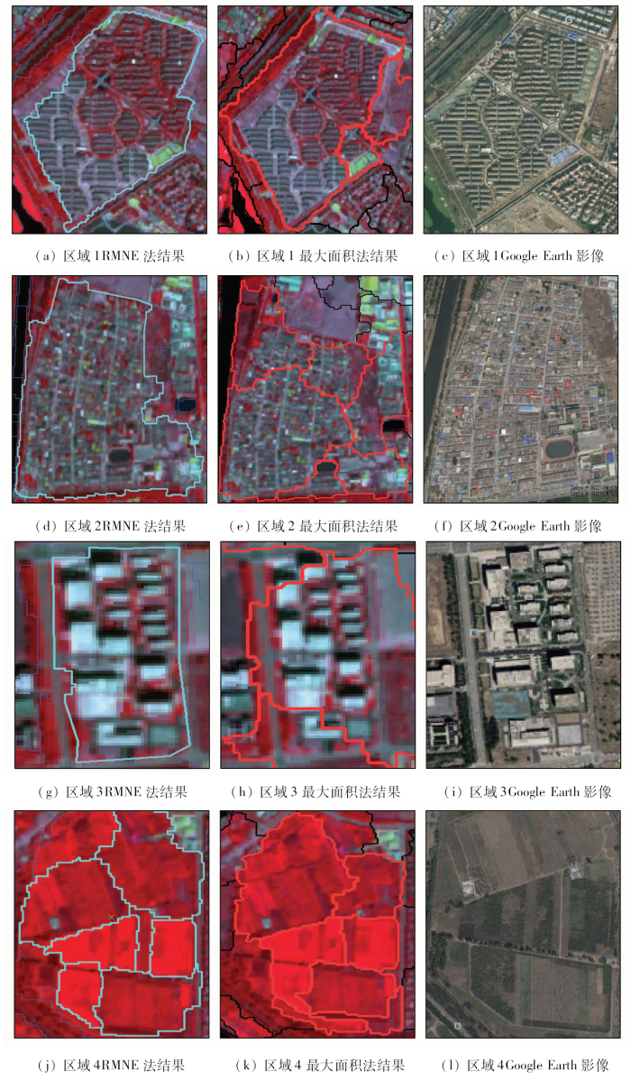
图6
多尺度分割结果与参考影像对比
Fig.6
Comparison of multi-scale segmentation results and reference images
可以发现RMNE方法分割得到的结果可以更好地对应实际地物对象,更具有地理意义,匹配度更高,故RMNE方法得到的最优分割尺度更优。
4 结论
本文提出了一种多尺度分割的最优分割尺度选取方法(RMNE),对研究区的SPOT6多光谱影像数据进行多尺度分割,通过与Google Earth影像对比可知,分割得到的影像对象大小与地物实际大小较为相符,实验结果验证了RMNE方法的有效性,并得出以下结论:
1)利用RMNE方法得到研究区的最优分割尺度组合为30,60和80,表明本文提出的采用对象的纹理信息熵和与邻域均值差分绝对值评价对象的同质性和异质性是有效的,对高空间分辨率遥感影像是适用的。
2)与最大面积法和优度函数法的结果进行对比可知,RMNE方法的分割结果更符合地物的实际大小和形状,具有明显优势,所以纹理信息的加入更有利于多尺度分割的最优分割尺度选择。
但是,本文的分割尺度从10开始,以10为步长,增加到100,尺度范围设置的略为宽泛。下一步将细化步长值,更精确地定位分割尺度。
参考文献
A multiscale object-specific approach to digital change detection
[J].
DOI:10.1016/S0303-2434(03)00010-2
URL
[本文引用: 1]

Landscape spatial pattern is dependent not only on interacting physiographic and physiological processes, but also on the temporal and spatial scales at which the resulting patterns are assessed. To detect significant spatial changes occurring through space and time three fundamental components are required. First, a multiscale dataset must be generated. Second, a change detection framework must be applied to the multiscale dataset. Third, a procedure must be developed to delineate individual image-objects and identify them as they change through scale. In this paper, we introduce an object-specific multiscale digital change detection approach. This approach incorporates multitemporal SPOT Panchromatic (Pan) data, object-specific analysis (OSA), object-specific up-scaling (OSU), marker-controlled watershed segmentation (MCS) and image differencing change detection. By applying this framework to SPOT Pan data, image-objects that have changed between registration dates can be identified and delineated at their characteristic scale of expression. Results illustrate that this approach has the ability to automatically detect changes at multiple scales as well as suppress sensor related noise. This study was conducted in the forest region of the rebro Administrative Province, Sweden.
Parameter selection for region-growing image segmentation algorithms using spatial autocorrelation
[J].
DOI:10.1080/01431160600617194
URL
[本文引用: 2]
http://www.tandfonline.com/doi/abs/10.1080/01431160600617194
The factor of scale in remote sensing
[J].
DOI:10.1016/0034-4257(87)90015-0
URL
[本文引用: 1]
Thanks to such second- and third-generation sensor systems as Thematic Mapper, SPOT, and AVHRR, a user of digital satellite imagery for remote sensing of the earth's surface now has a choice of image scales ranging from 10 m to 1 km. The choice of an appropriate scale, or spatial resolution, for a particular application depends on several factors. These include the information desired about the ground scene, the analysis methods to be used to extract the information, and the spatial structure of the scene itself. A graph showing how the local variance of a digital image for a scene changes as the resolution-cell size changes can help in selecting an appropriate image scale. Such graphs are obtained by imaging the scene at fine resolution and then collapsing the image to successively coarser resolutions while calculating a measure of local variance. The local variance/resolution graphs for the forested, agricultural, and urban/suburban environments examined in this paper reveal the spatial structure of each type of scene, which is a function of the sizes and spatial relationships of the objects the scene contains. At the spatial resolutions of SPOT and Thematic Mapper imagery, local image variance is relatively high for forested and urban/suburban environments, suggesting that information-extracting techniques utilizing texture, context, and mixture modeling are appropriate for these sensor systems. In agricultural environments, local variance is low, and the more traditional classifiers are appropriate.
面向对象高分辨率影像信息提取中的尺度效应及最优尺度研究
[J].本文从面向对象的遥感信息提取中的尺度效应研究入手,对影像对象的分形维数、紧凑度、面积、 均值、标准差和与邻域均值差分等特征进行了实验。在此基础上,根据"类内同质性大,类间异质性大"的最佳分类原则,提出了面向对象的RMAS方法,该方法 的思想是,当对象RMAS值最大时,对象内部的异质性最小,对象外部的异质性最大,此时的分割尺度为类别提取的最优分割尺度。根据最优尺度下信息提取精度 最高的原理,实验验证了该方法的可行性,且能获得较好的分类结果。
Scale effect and optimal scale in object-oriented information extraction of high spatial resolution remote sensing image
[J].
地物大小、对象尺度、影像分辨率的关系分析
[J].
DOI:10.3969/j.issn.1004-0323.2006.03.013
URL
Magsci
[本文引用: 3]
<p>遥感数据的分辨率越来越高, 给地物信息提取提出了新的挑战。利用基于像元的分类技术和基于多尺度分割的面向对象分类技术对高分辨率影像进行分类实验, 分析地物大小、对象尺度与影像分辨率的关系。实验结果表明不同地物由于其空间尺度不同, 与之相适宜的空间分辨率和对象尺度也不同, 在适宜分辨率的影像提取有较高的精度, 在适宜的对象尺度上提取对象信息有更高的精度。分析也表明面向对象的多尺度影像分类技术适应了不同地物有其相适宜的空间分辨率, 在适宜尺度影像层中提取地物, 其分类精度大大高于基于像元的分类方法。</p>
Analysis to the relationship of feature size,objects scales,image resolution
[J].
多尺度分割的高分辨率遥感影像变化检测
[J].
DOI:10.11834/jrs.20165074
URL
[本文引用: 1]
针对高空间分辨率的遥感影像,提出了一种基于多尺度分割的变化检测算法。采用Mean-Shift分割算法对影像进行多尺度分割,构建了不同尺度上的地理对象,以不同尺度上的地理对象灰度均值构建了变化检测的多尺度特征向量,采用变化矢量分析法获得最后的变化检测结果。以城镇区和农田区的Quick Bird影像对本文算法进行了检验,从精度评价的效果来看,无论城镇区还是农田区,采用面向对象的变化检测方法精度都高于基于单像素的检测方法,且当尺度层数固定时,多尺度组合的变化检测结果优于单一尺度的变化检测结果,对城镇、农田区域的变化检测的精度分别达到87.57%和81.55%。本文算法既可以顾及大面积同质区域变化,又可以反映小的地物目标及边缘部分的变化,能够很好地满足城镇、农田等不同环境背景下的变化检测需求,在国土资源监测中具有一定的应用价值。
Change detection for high-resolution images using multilevel segment method
[J].
赣州稀土矿山高分辨率遥感影像分割的最优尺度选取
[J].
DOI:10.3969/j.issn.1672-5867.2013.09.013
URL
[本文引用: 2]
随着高分辨率遥感影像在矿山分类工作中的广泛应用,面向对象的多尺度分割技术成为研究热点。最优尺度的选取是此类技术的关键。为获取高分遥感影像最适宜的分割尺度,本文以赣州稀土矿山高分辨率遥感影像为源数据,选择与邻域绝对均值差分方差比方法 RMAS(Ratio of Mean Difference to Neighbors(ABS)to Standard Deviation)方法获取最优分割尺度。通过分割质量值对分割结果进行评价分析,研究验证了RMAS方法的可行性。
Optimal scale selection research of high-resolution remote sensing images of rare earth mine in Ganzhou
[J].
Adaptive scale fixing for multiscale texture segmentation
[J].
DOI:10.1109/TIP.2005.860340
URL
PMID:16435554
[本文引用: 1]
This paper addresses two challenging issues in unsupervised multiscale texture segmentation: determining adequate spatial and feature resolutions for different regions of the image, and utilizing information across different scales/resolutions. The center of a homogeneous texture is analyzed using coarse spatial resolution, and its border is detected using fine spatial resolution so as to locate the boundary accurately. The extraction of texture features is achieved via a multiresolution pyramid. The feature values are integrated across scales/resolutions adaptively. The number of textures is determined automatically using the variance ratio criterion. Experimental results on synthetic and real images demonstrate the improvement in performance of the proposed multiscale scheme over single scale approaches.
A multiscale texture analysis procedure for improved forest stand classification
[J].
DOI:10.1080/0143116042000192367
URL
[本文引用: 1]
Image texture is a complex visual perception. With the ever-increasing spatial resolution of remotely sensed data, the role of image texture in image classification has increased. Current approaches to image texture analysis rely on a single band of spatial information to characterize texture. This paper presents a multiscale approach to image texture where first and second-order statistical measures were derived from different sizes of processing windows and were used as additional information in a supervised classification. By using several bands of textural information processed with different window sizes (from 5 5 to 15 15) the main forest stands in the image were improved up to a maximum of 40%. A geostatistical analysis indicated that there was no single window size that would adequately characterize the range of textural conditions present in this image. A number of different statistical texture measures were compared for this image. While all of the different texture measures provided a degree of improvement (from 4 to 13% overall), the multiscale approach achieved a higher degree of classification accuracy regardless of which statistical procedure was used. When compared with single band texture measures, the level of overall improvement varied between 4 and 8%. The results indicate that this multiscale approach is an improvement over the current single band approach to analysing image texture.
Multi-scale GEOBIA with very high spatial resolution digital aerial imagery:Scale,texture and image objects
[J].
DOI:10.1080/01431161003745608
URL
[本文引用: 1]
This study used geographic object-based image analysis (GEOBIA) with very high spatial resolution (VHR) aerial imagery (0.3 m spatial resolution) to classify vegetation, channel and bare mud classes in a salt marsh. Three classification issues were investigated in the context of segmentation scale: (1) a comparison of single- and multi-scale GEOBIA using spectral bands, (2) the relative benefit of incorporating texture derived from the grey-level co-occurrence matrix (GLCM) in classifying the salt marsh features in single- and multi-scale GEOBIA and (3) the effect of quantization level of GLCM texture in the context of multi-scale GEOBIA. The single-scale GEOBIA experiments indicated that the optimal segmentation was both class and scale dependent. Therefore, the single-scale approach produced an only moderately accurate classification for all marsh classes. A multi-scale approach, however, facilitated the use of multiple scales that allowed the delineation of individual classes with increased between-class and reduced within-class spectral variation. With only spectral bands used, the multi-scale approach outperformed the single-scale GEOBIA with an overall accuracy of 82% vs. 76% (Kappa of 0.71 vs. 0.62). The study demonstrates the potential importance of ancillary data, GLCM texture, to compensate for limited between-class spectral discrimination. For example, gains in classification accuracies ranged from 3% to 12% when the GLCM mean texture was included in the multi-scale GEOBIA. The multi-scale classification overall accuracy varied with quantization level of the GLCM texture matrix. A quantization level of 2 reduced misclassifications of channel and bare mud and generated a statistically higher classification than higher quantization levels. Overall, the multi-scale GEOBIA produced the highest classification accuracy. The multi-scale GEOBIA is expected to be a useful methodology for creating a seamless spatial database of marsh landscape features to be used for further geographic information system (GIS) analyses.
结合多尺度纹理特征的遥感影像面向对象分类
[J].
DOI:10.19349/j.cnki.issn1006-7949.2016.07.005
URL
[本文引用: 2]
地物具有多尺度的特点,单一尺度难以准确描述遥感影像包含的地物纹理信息.利用我国自行研发的高分一号遥感影像数据,采用灰度共生矩阵对第一主成分进行纹理特征提取,利用Jeffries-Matusit距离选择多尺度组合,并通过单一纹理结合多光谱数据的分类精度,以及纹理特征间的相关性,最终选择多尺度纹理特征组合进行面向对象分类.研究结果表明:结合多尺度纹理特征组合的面向对象GF-1影像分类能有效提取地物信息,总体分类精度达到81.75%,Kappa系数0.78.
Object-oriented classification with multi scale texture feature based on remote sensing image
[J].
A new multi-scale analytic algorithm for edge extraction of strawberry leaf images in natural light
[J].In this study, a new algorithm was proposed for edge extraction of greenhouse strawberry leaf in natural light based on the 4-level daubechies 5 ('db5') wavelet decomposition. This algorithm adopts different segmentation methods for the reconstructed images at different scales to erase the external background and the internal leaf vein interference. There were two advantages of this method. One...
基于最优尺度和规则的高分辨率影像分类研究
[J].高分辨率影像的广泛应用推进面向对象影像分析(OBIA)的发展,而分割作为面向对象分类的关键步骤,其尺度的选择直接关系到地物信息的提取。空间尺度是地物的固有属性,在合适的分割尺度下可以更好地挖掘地物信息。本文结合最大面积法和分割质量评价模型对张山营镇影像进行分割实验,先通过分析对象最大面积初步得到最优尺度范围,后结合分割质量评价模型以确定最优分割尺度层次。在此基础上,综合样本提取的光谱、纹理等特征进行规则训练,最终完成面向对象的土地覆被分类研究。结果显示:基于多层次最优尺度的规则分类方法获得更好的分类结果,其总体精度为88.8%,Kappa系数为0.861,而基于单一尺度的最邻近法总体精度81.4%,Kappa系数0.773,基于单一尺度的规则分类法总体精度为83.2%,Kappa系数为0.85。
Classification of high-resolution image based on optimal scale and rule
[J].
综合多层优选尺度的高分辨率影像分割
[J].
DOI:10.3724/SP.J.1047.2016.00632
URL
Magsci
[本文引用: 1]
<p>采用面向对象方法处理高空间分辨率遥感影像时,影像分割质量对后续影像的信息提取结果影响很大。本文主要针对高分辨率影像分割中地物多尺度的问题,提出了一种基于多层优选尺度的高分辨率影像分割算法。该算法首先采用一系列规律变化的尺度对高分辨率影像进行多尺度分割,然后通过单分割层全局标准差的变化与尺度的关系确定一组最优分割尺度。在此基础上,通过各优选分割层之间的包含关系,局部建立多层次对象树,从整体上形成影像森林;通过局部同质性异质性综合评价指数的比较及父层光谱特征的限制来选取多层次对象树中的优势对象,从而获得最终的高分辨率影像分割结果。最后,本文分别采用了Geoeye和ZY3多光谱影像进行了2组分割实验,结果表明本文算法能有效地提高正常分割影像对象的比例。</p>
Optimal scales based segmentation of high spatial resolution remote sensing data
[J].
Contour and texture analysis for image segmentation
[J].
DOI:10.1023/A:1011174803800
URL
[本文引用: 2]
This paper provides an algorithm for partitioning grayscale images into disjoint regions of coherent brightness and texture. Natural images contain both textured and untextured regions, so the cues of contour and texture differences are exploited simultaneously. Contours are treated in the intervening contour framework, while texture is analyzed using textons . Each of these cues has a domain of applicability, so to facilitate cue combination we introduce a gating operator based on the texturedness of the neighborhood at a pixel. Having obtained a local measure of how likely two nearby pixels are to belong to the same region, we use the spectral graph theoretic framework of normalized cuts to find partitions of the image into regions of coherent texture and brightness. Experimental results on a wide range of images are shown.
