

0 引言
我国城市化发展快速、地域分布广等特点,决定了该过程必然面临诸多新问题[10,11]。就资源领域而言,同种资源因管理部门和调查方法差异,会出现资源评估数据不一致等情况,严重影响管理决策。为此,国家调整组建了自然资源部,以解决山水林田湖草等自然资源的评估与监测[12],面临的首要问题是如何开展顶层设计、统一评价与监测标准、形成对应的技术体系,准确获取各种资源空间布局等基础资料,服务于资源保护与优化利用。相比自然生态系统,城市生态系统人为干扰程度高,高楼林立、下垫面异质性高[13],绿地呈斑块化、破碎化分布,增加了评估与监测的难度,基于自然生态系统发展的传统抽样调查方法与结果可能与实际不符[14,15]。为满足新时期城市建设与生态环境保护需求,迫切需要开展精细化的城市绿地资源监测、建立可行的评估方法与监测系统,准确、及时掌握绿地资源的状况与动态变化等基础数据,服务城市建设与管理决策。
为此,本文针对国家对城市绿地等自然资源评估与监测业务需求的紧迫性,以城市绿地中常见的植被和水体为例,从资源的数量、质量与生态价值3个层次梳理对比主流的监测评价方法并分析其优势; 在此基础上,结合本文作者近期研究成果,讨论城市绿地多尺度监测与评价方法,为我国新时期城市自然资源管理等工作提供方法支持。
1 城市植被评估与监测方法
图1
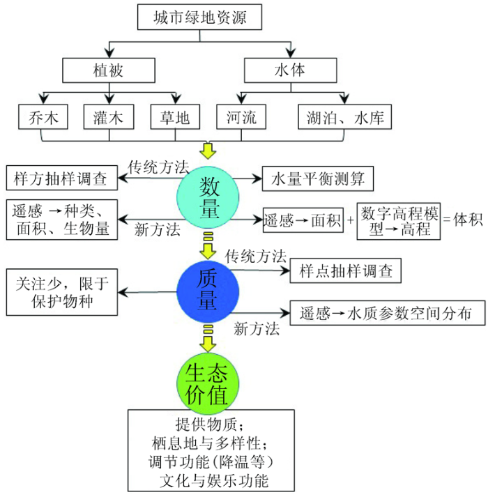
图1
城市绿地资源不同层次评价与监测方法
Fig.1
Different methods used to assess and monitor urban green space resources
1.1 数量方面
随着20世纪下半叶遥感技术的发展,从空中监测地表成为可能[21,22],发展了针对自然生态系统中森林资源种类判别、面积区划的方法等[23,24,25,26,27,28]。我国从第6次全国森林资源清查开始增加遥感抽样调查,以快速、高效地获取相关基础数据,评估森林资源[19]。但这些评估方法主要基于中低空间分辨率(<30 m)的卫星遥感数据,难以应用于斑块破碎、面积较小的城市绿地。近20 a来高空间分辨率商业卫星数据的发展,可提供地表0.5~5 m精细尺度的可见光遥感数据[21,29],城市绿地资源精细化评估与监测成为可能,包括植被种类识别、冠幅大小与数量等评估[30,31,32,33]。尤其是最近的三维激光雷达,可提取乔木的高度和垂直结构信息,如冠幅、胸径和树高、蓄积量/生物量等[34,35,36,37]。图2为本文作者利用三维激光雷达监测评估乔木资源的案例,图2(a)和(b)是在高植被覆盖度的森林区域,采用定点式激光扫描,以观测点为圆心360°探测,经数据处理后,提取各株乔木的三维信息,据此可获取树高、胸径、蓄积量/生物量等信息,与传统标准木调查方法获取结果精度相当(如胸径R2=0.99),且能获得林分任意树木的信息及空间位置关系等,提供更多的精准数据[35]; 图2(c)和(d)是利用最新研发的背包式激光雷达,在行走中探测道路周围植被的三维信息,根据点云提取植被相关信息,无需考虑样方数量、样方面积等问题,有助于调查斑块破碎的城市植被,若将该设备置于车载平台,可形成车载移动式观测,具有较好的应用前景[38]。
图2
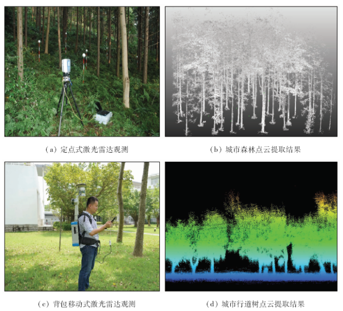
图2
三维激光雷达调查评估城市植被方法示例
Fig.2
Examples showing assessment and monitoring of urban trees based on three-dimensional laser scanning
1.2 生态功能
目前,城市蒸散发典型的测算方法包括: ①针对乔木的树干液流计,用于测算单株树木的蒸腾量[58,59]; ②针对草本或低矮灌木的称重式蒸渗仪,即根据水量平衡方程在控制条件下测量蒸散发之外的变量,推算蒸散发[60,61]; ③针对不同植被类型,借助世界粮农组织参考作物蒸散发的概念,根据彭曼-蒙蒂斯公式与气象观测数据获得参考蒸散发,利用植被系数(landscape or garden coefficient)推算实际蒸散发[62,63]。尽管可将单株树干液流测算的蒸腾量推绎到林分或景观尺度,但结果的代表性与精确性值得商榷[64]。水量平衡方法测算结果代表某区域平均值,难以反映区域内蒸散发的空间差异,且仅在观测条件较好的固定试验场所,才可能准确测算水分平衡的各分量。城市区域高楼林立、对流强烈、微气象环境差异大,彭曼-蒙蒂斯公式仅适用于平坦均质地表; 加之植被系数受多种因素影响,缺乏不同水热条件下的观测值,亦影响推算的蒸散发,且同种植被赋予相同的植被系数,结果同样不能反映空间差异。
热红外卫星遥感的发展(表1)提供了100 m左右(如Landsat系列数据、ASTER数据)至1 km(如MODIS数据)的地表温度[65],如图3所示,促进了城市景观尺度地表温度空间差异及其与植被关系的研究 [66,67]。但基于卫星遥感地表温度和植被蒸腾机理探讨降温的研究相对较少[68,69],一方面城市中蒸散发及其植被蒸腾组分定量困难,二是目前较低空间分辨率的卫星遥感数据(约100 m)制约了对城市蒸散发深入、系统的研究,因为城市植被斑块破碎、通常在10 m范围内都会因植被类型差异而使蒸散发具有高异质性[70],用100 m的热红外遥感数据研究城市全局尺度(104~106 m)基本可行,但限制了街区尺度(<104 m)的精细研究。近年无人机的发展使亚米级遥感数据获取成为可能,无人机光学数据获取相对成熟[71]。受传感器与无人机搭载平台耦合等制约,高空间分辨率热红外数据的无人机获取仍然面临较大挑战,如确定图像地理空间位置、拼接不同航带图像等。本文作者经过前期探索,研发了基于热红外温度的三温模型,可测算城市草坪、灌木、乔木等植被的蒸散发,与传统的波文比能量平衡法、树干液流法等测算结果接近,但可提供蒸散发空间分布信息、实现了城市复杂下垫面蒸散发精准估算[42-43, 53]; 提出移动式运动样带法,可定量研究条带状城市绿地植被对温度的影响(图4)[41]; 近期解决了热红外传感器与无人机平台兼容搭载、地理坐标定位、数据拼接处理等,实现了亚米级地表温度及蒸散发时空分布数据获取(图5),有望为系统评估城市绿地蒸散发及其降温效果提供新方法。
表1 典型的卫星热红外遥感数据
Tab.1
| 传感器 | 卫星平台 | 幅宽/ km | 空间分 辨率/m | 时间分 辨率 |
|---|---|---|---|---|
| TM | Landsat(美国) | 185 | 120 | 16 d |
| ETM+ | 60 | |||
| OLI | 100 | |||
| ASTER | Terra(美国) | 60 | 90 | 9~16 d |
| IRMSS | CBERS-01/02(中国) | 120 | 156 | 26 d |
| IRS | HJ-1B(中国) | 720 | 300 | 4 d |
| VIIRS | NPP(美国) | 3 000 | 400 | 4 h |
| MODIS | Terra/Aqua(美国) | 2 330 | 1 000 | 1 d |
| AVHRR | NOAA(美国) | 2 800 | 1 100 | 0.5 d |
| SEVIRI | MSG(欧盟) | 全球 | 3 000 | 15 min |
| SVISSR | FY-2(中国) | 全球 | 5 000 | 1 h |
图3
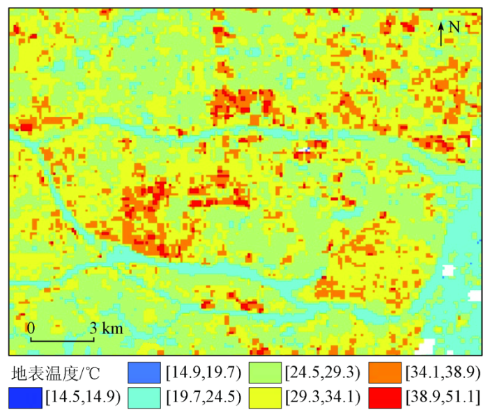
图3
基于ASTER AG100v003产品的广州市海珠区2000—2008年平均地表温度空间分布
Fig.3
Distribution of average land surface temperature based on ASTER product (AG100v003) for Haizhu District, Guangzhou City during 2000—2008
图4
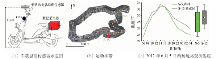
图4
基于车载(电动摩托车)移动式的运动样带城市绿地类型与温度关系研究方法
(运动样带位于广东省深圳市南山区大学城)
Fig.4
A mobile traverse observation method to study the relationship between air temperature and different types of urban green spaces
图5
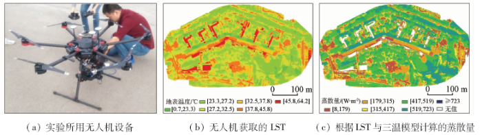
图5
基于无人机与热红外遥感的城市绿地蒸腾作用与地表温度关系研究
(研究区位于
Fig.5
An unmanned aerial vehicle and thermal infrared based method to study the mechanical impact of ET on LST
2 城市水体评估与监测方法
2.1 水量评估
传统的水资源数量评估,以降水、径流为主要要素,多在流域尺度根据水量平衡原理开展。若能将城市生态系统的各水文分量监测清楚,可以测算水总量。在仅考虑城市河流、湖泊水库情况下,具体水量的评估可考虑使用体积描述,即水面面积与水深之积。遥感数据测算面积精度非常高、相对容易。此时,仅需获得水深信息即可。目前数字高程模型可提供高程信息,如30 m空间分辨率的ASTER GDEM,高程精度平均为(7.4±12.7) m。我国最新的高分七号卫星可获取亚米级立体影像,高程精度可望高达1.5 m。为利用高精度遥感信息开展水量评估提供了丰富的数据源。基于遥感的水量评估方法,可获取空间任意位置水量信息,弥补了传统水量平衡测算法只能获取区域平均值的不足。
2.2 水质评估与监测
随着生态宜居等城市建设需求,城市水体水质成为政府、研究人员与城市居民关注的焦点。传统的水质评估依赖监测断面定点观测数据,但受到监测断面数量、采样频次等限制,评价结果通常难以反映水质的时空分布信息。遥感数据覆盖范围广、快速成像与周期成像的特征,为水质时空监测提供了强有力的工具。目前典型的监测评估要素包括水温、叶绿素浓度、总悬浮物、可溶性有机污染物等[72]。根据《全国城市市政基础设施建设“十三五”规划》,将整治城市黑臭水体2 000多个、总长度约5 800 km,建立城市水质监测与评估方法必然是治理的重要内容之一。图6是本文作者利用30 m空间分辨率的Landsat系列数据评估广东省珠海市大镜山水库(约1 km2)叶绿素浓度时空分布的案例,尽管采用线性回归算法,却弥补了传统水质评估中有限采样点难以反映水质空间分布的不足[73]。考虑到我国中小型水库(库容小于106 m3)数量高达93 308座[74],是未来水质与水量监测与管理的重点,传统人工调查方法难以快速获取水质空间信息、周期更新更难,基于遥感影像的水质评估方法可快速、周期性地获取水质时空分布信息,必将发挥重要作用。城市水质遥感监测与评估的难点在于,由于水体浑浊度高,无机悬浮颗粒、可溶性有机污染物的光谱特征与叶绿素重叠,水体光学特性复杂,增加了水质参数的反演难度[73]。且卫星遥感数据空间分辨率与光谱分辨率的博弈,导致多(高)光谱数据的低空间分辨率制约城市河流、湖泊、水库的识别,或高空间分辨率影像的低光谱分辨率制约水质参数的精细化遥感反演。因此,基于无人机高光谱、高时空分辨率的数据获取与水质反演是未来城市水质监测与评估的重要手段。
图6
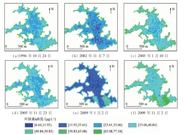
图6
基于Landsat TM/ETM+遥感数据的水质遥感多时间序列监测评估示 例: 广东省珠海市大镜山水库叶绿素a浓度时空分布图
Fig.6
Examples showing chlorophyll-a concentration (mg/L) monitoring at Dajingshan Reservoir, Zhuhai City, Guangdong, based on Landsat TM/ETM+ series datasets
3 结论与建议
1)尽管基于样方的传统抽样方法可获得城市绿地的数量信息,但城市绿地高度斑块化特征限制了样方结果尺度推绎。
2)卫星遥感是监测城市绿地的有效手段,可准确获取绿地空间分布、面积、种类、质量变化等信息,但生物量(或蓄积量)、体积等信息需要米级(< 5 m)遥感数据和其他新技术支持精细化研究。
3)无人机可获得亚米级(如< 5 cm)数据,满足精细化监测需求,但受飞行管制、电池续航能力等限制,数据覆盖范围有限,且数据拼接等后处理复杂、传统的数据处理或反演算法可能不适用于亚米级空间分辨率数据。
4)城市绿地类型、面积与城市温度关系研究较多,但当前100 m(及更粗空间分辨率)的热红外地表温度数据难以支持绿地蒸腾降温机理等精细化研究。可见,城市绿地的精细化资源评估与监测仍面临诸多挑战,建议未来加强米级、亚米级遥感数据在城市绿地评估与监测中的应用研究,加强研究多传感器与无人机搭载平台耦合及数据处理业务化流程、研发适用于城市绿地精细化管理的反演算法。
参考文献
World urbanization prospects 2018:Highlights
[EB/OL].[
Realizing China’s urban dream
[J].
Historic and future increase in the global land area affected by monthly heat extremes
[J].
Heat wave impact on mortality in Pudong New Area,China in 2013
[J].
中国的城市化与生态环境问题——“2018中国人文社会科学环境论坛”研讨述评
[J].
Urbanization in China and its eco-environmental effects:a review on the discussion of “2018 Chinese humanities and social sciences environment forum”
[J].
基于供给侧的城市绿地系统规划新思考
[J].
New thought on urban green space system planning based on the perspective of supply side
[J].
城市绿色空间的生态系统服务功能研究进展:指标、方法与评估框架
[J].
Review of study on ecosystem services function of urban green spaces:Indicators,methods and assessment framework
[J].
城市绿地空间供需评价与布局优化——以徐州中心城区为例
[J].
Spatial supply-demand evaluation and layout optimization for urban green space:A case study of Xuzhou central district
[J].
21世纪中国的城市化特点及其生态环境挑战
[J].
China’s urbanization and its ecological environment challenges in the 21st century
[J].
中国城镇生态环境遥感监测现状及发展趋势
[J].
Progress of urban ecological environment monitoring by remote sensing in China
[J].
我国自然资源、自然资源资产监测发展现状及问题分析
[J].
Research on the current situation and problems of natural resources monitoring and natural resources assets monitoring in China
[J].
Global change and the ecology of cities
[J].
城市植物分层随机抽样调查方案设计的方法探讨
[J].
Proposed procedure in designing and planning stratified random selection investigation of urban vegetation
[J].
Effects of sampling approaches on quantifying urban forest structure
[J].
基于高光谱特征选择和RBFNN的城市植被胁迫程度监测
[J].
Urban vegetation stress level monitoring based on hyperspectral feature selection and RBF neural network
[J].
高光谱遥感城市植被胁迫监测研究
[J].
Research on urban vegetation stress monitoring by hyperspectral remote sensing
[J].
Sampling methods for estimating change in forest resources
[J].
森林资源抽样调查技术方法研究进展
[J].
Progress in sampling technology and methodology in forest inventory
[J].
Species-area relationships always overestimate extinction rates from habitat loss
[J].
2019年中国陆表定量遥感发展综述
[J].
Review of China’s land surface quantitative remote sensing development in 2019
[J].
In situ/remote sensing integration to assess forest health:A review
[J].
Optical remote-sensing techniques for the assessment of forest inventory and biophysical parameters
[J].
Local parameter estimation of topographic normalization for forest type classification
[J].
Understanding forest health with remote sensing Part I:A review of spectral traits,processes and remote-sensing characteristics
[J].
“3S”及抽样技术在森林资源动态监测中的应用
[J].
Application of “3S” technology and sampling techniques to dynamic monitoring of forest resources
[J].
中国历史时期森林空间格局网格化重建方法研究——以东北地区为例
[J].
An approach of spatially-explicit reconstruction of historical forest in China:A case study in Northeast China
[J].
浙江省森林信息提取及其变化的空间分布
[J].
The extraction of forest information and the spatial distribution of its change in Zhejiang Province
[J].
Remote sensing platforms and sensors:A survey
[J].
基于高分辨率卫星图像的立木材积表的编制
[J].
Compiling the standing volume table of Chinese fir based on the high-resolution satellite image
[J].
城市植被尺度鉴别与分类研究
[J].城市地物具有多尺度分布特点,尺度鉴别与确定是分类的前提.提出改进的面积相对差指标,根据城市植被的分布状态确定最优分割尺度.采用面向对象方法,利用对象的光谱和空间信息对高空间分辨率影像进行植被分类.与基于像元的传统光谱分类方法和单尺度分类结果比较,最优分割尺度的鉴别和面向对象的分类方法分类精度较高,6种城市植被的分类总精度达85.5%,Kappa系数为0.83;同时有效抑制了光谱数据分类中存在的地物破碎问题.
Scale identification for urban vegetation classification using high spatial resolution satellite data
[J].
基于WorldView-2影像城市绿地信息提取研究
[J].
WorldView-2 images based urban green space information extraction
[J].
Segment-constrained regression tree estimation of forest stand height from very high spatial resolution panchromatic imagery over a boreal environment
[J].
LiDAR remote sensing of forest structure
[J].
Retrieval and accuracy assessment of tree and stand parameters for Chinese fir plantation using terrestrial laser scanning
[J].
Structure from motion photogrammetry in forestry:A review
[J].DOI:10.1007/s40725-019-00094-3 URL [本文引用: 1]
Canopy detection over roads using mobile LiDAR data
[J].
生物多样性近地面遥感监测:应用现状与前景展望
[J].
A near-surface remote sensing platform for biodiversity monitoring:Perspectives and prospects
[J].DOI:10.17520/biods.2016059 URL [本文引用: 1]
城市植被:特点、类型与功能
[J].
Urban vegetation:Its characteristic,type and function
[J].
惠州城市植被的滞尘效应
[J].
The dust retention effect of urban vegetation in Huizhou,Guangdong Province
[J].
Experimental studies on the effects of green space and evapotranspiration on urban heat island in a subtropical megacity in China
[J].
Characteristics of evapotranspiration of urban lawns in a sub-tropical megacity and its measurement by the “Three Temperature Model + infrared remote sensing” method
[J].
Quantifying the evapotranspiration rate and its cooling effects of urban hedges based on Three-Temperature model and infrared remote sensing
[J].
Urban greening to cool towns and cities:A systematic review of the empirical evidence
[J].
Local climate zones for urban temperature studies
[J].
Green and cool roofs’ urban heat island mitigation potential in tropical climate
[J].
City size and the urban heat island
[J].
More intense,more frequent,and longer lasting heat waves in the 21st century
[J].
Future heat-waves,droughts and floods in 571 European cities
[J].
Avoided climate impacts of urban and rural heat and cold waves over the U.S. using large climate model ensembles for RCP8.5 and RCP4.5
[J].
气候变化科学与人类可持续发展
[J].
Climate change science and sustainable development
[J].
An evapotranspiration-interception model for urban areas
[J].
An advanced approach for measuring the transpiration rate of individual urban trees by the 3D three-temperature model and thermal infrared remote sensing
[J].
A review on global terrestrial evapotranspiration:Observation,modeling,climatology,and climatic variability
[J].
A review of remote sensing based actual evapotranspiration estimation
[J].
水文学研究进展与展望
[J].
Progress and prospect of hydrological sciences
[J].
近70年来中国自然地理与生存环境基础研究的重要进展与展望
[J].
Major advances in studies of the physical geography and living environment of China during the past 70 years and future prospects
[J].
Transpiration of urban forests in the Los Angeles metropolitan area
[J].
高温天气植被蒸腾与遮荫降温效应的变化特征
[J].
Characteristics of vegetation shading and transpiration cooling effects during hot summer
[J].
Living green walls:Estimation of water requirements and assessment of irrigation management
[J].
Precipitation collection and evapo(transpi)ration of living wall systems:A comparative study between a panel system and a planter box system
[J].
A guide to estimating irrigation water needs of landscape plantings in California
[R].
Performance evaluation of five Mediterranean species to optimize ecosystem services of green roofs under water-limited conditions
[J].
Tree transpiration in a multi-species Mediterranean garden
[J].
Satellite-derived land surface temperature:Current status and perspectives
[J].
DOI:10.1016/j.rse.2012.12.008
URL
[本文引用: 1]

Land surface temperature (LST) is one of the key parameters in the physics of land surface processes from local through global scales. The importance of LST is being increasingly recognized and there is a strong interest in developing methodologies to measure LST from space. However, retrieving LST is still a challenging task since the LST retrieval problem is ill-posed. This paper reviews the current status of selected remote sensing algorithms for estimating LST from thermal infrared (TIR) data. A brief theoretical background of the subject is presented along with a survey of the algorithms employed for obtaining LST from space-based TIR measurements. The discussion focuses on TIR data acquired from polar-orbiting satellites because of their widespread use, global applicability and higher spatial resolution compared to geostationary satellites. The theoretical framework and methodologies used to derive the LST from the data are reviewed followed by the methodologies for validating satellite-derived LST. Directions for future research to improve the accuracy of satellite-derived LST are then suggested. (c) 2012 Elsevier Inc.
Study on the cooling effects of urban parks on surrounding environments using Landsat TM data:A case study in Guangzhou,southern China
[J].
DOI:10.1080/01431161.2012.676743
URL
[本文引用: 1]
The temperature cooling effects of ten urban parks on surrounding environments in Guangzhou, southern China, are analysed and quantified using Landsat Thematic Mapper data. The results show that there is a temperature rise (about 1.74 degrees C) between green spaces of parks and bare-ground areas of the surroundings. For those parks whose green area percentage is more than 69% and length: width ratio is close to 1, the average temperature differences between boundaries and surrounding sites of parks have linear relationships with the green areas of parks (R-2 > 0.82). Moreover, the nonlinear relationship between the average cooling distance of parks and green areas can be simulated very well using a logarithmic curve (R-2 > 0.93). When the green areas of parks are smaller than 10 566 m(2), parks will have no temperature cooling effects on their surrounding environments. When the green areas of parks reach 740 000 m(2), the increase of temperature cooling distance is less than 1 m per 10 000 m(2) increase of the green area. The most appropriate size of green areas of urban parks should fall between 10 566 and 740 000 m(2). For those parks with water areas larger than 128 889 m(2), the temperature cooling effects are usually more remarkable. When the length: width ratios of the green areas of urban parks are more than or equal to 2, their temperature cooling distances are always larger than those with length: width ratios equal to 1 given similar green area. Parks with larger green areas (37 163 m(2)) or larger water areas (>128 889 m(2)) will have more significant temperature cooling effects in June than in October.
Efficiency of parks in mitigating urban heat island effect:An example from Addis Ababa
[J].
DOI:10.1016/j.landurbplan.2013.12.008
URL
[本文引用: 1]
Evapotranspiration estimation considering anthropogenic heat based on remote sensing in urban area
[J].
Estimation of hourly and daily evapotranspiration and soil moisture using downscaled LST over various urban surfaces
[J].
Actual evapotranspiration estimation for different land use and land cover in urban regions using Landsat 5 data
[J].
无人机遥感技术在城市绿地监测中的应用进展
[J].
Review on the applications of UAV remote sensing technology to urban green space monitoring
[J].
Aquatic color radiometry remote sensing of coastal and inland waters:Challenges and recommendations for future satellite missions
[J].
Remotely assessing and monitoring coastal and inland water quality in China:Progress,challenges and outlook
[J].
