

0 引言
海岸线是划分陆域和海域的界线,其形态上曲直各异,是水体、大气、人类活动共同作用的结果,国际地理信息委员会将海岸线确定为27个最重要的地表特征之一[1,2,3]。精准、快速、全面地监测海岸线动态信息,对于加强海洋资源开发与管理,实现海洋可持续发展具有重要的意义[4,5,6]。长期以来,以“测量拐点坐标,顺序连接成线”方式进行的野外实地测量是海岸线信息获取的重要手段,虽然精度较高,但是花费人工多、效率低下、工作周期长,而且受地理条件的限制,存在测量困难和无法到达区域,无法满足大范围提取的要求[7,8,9,10]。遥感技术凭借时效性强、观测范围大、成像谱段多、经济效益好等特点,能够有效克服海岸线实地测量中可能遇到的各种限制[11,12,13,14]。海岸线遥感信息提取方法可以分为2类: 目视解译和自动解译[15,16]。其中,目视解译法适用于范围较小的区域,虽然精度较高、提取结果连续性好,但易受操作人员主观因素影响,效率低下,难以满足海岸线信息快速提取和时空演变分析的时效性要求,而自动解译法以其时效性高、复用性强等特点成为了海岸线遥感信息提取的主要手段[17,18,19,20,21]。
海岸线信息遥感自动解译方法主要包括边缘检测法、面向对象法、阈值分割法、区域生长法和元胞自动机法等[22,23]。边缘检测法利用边缘检测算子提取水陆分界线,该方法对平直、简单海岸线效果较好,但抗噪性差,海岸线容易中断[24,25,26]。面向对象法综合利用遥感图像的光谱、空间和纹理对水陆进行分割,并结合解译标志提取海岸线信息,该方法精度较高,但规则设置复杂,时效性差[27,28,29,30]。阈值分割法利用目标物与背景地物的像元灰度值不同,通过设置相应的阈值分割出水体区域,该方法简单,运算速度快,但容易受到光谱相似性地物的影响[31,32,33,34]。区域生长法在一定规则支持下集合具备相似特性的像元,该方法较为成熟,但易受噪声影响,且在地物背景复杂的情况下易变形[35,36,37]。元胞自动机法通过计算某一邻域内各个方向的突变值来进行水陆分离,该方法在提取淤泥质海岸线时精度较高,但需要多次迭代,耗时较长[38,39,40,41]。
海岸线遥感信息提取往往建立在水体、陆地准确分离的基础上,在特定领域取得了成功,时效性较野外实地测量法有了很大提高。但是,由于近岸水体受人类活动、区域地形等影响很大,悬浮泥沙含量较高,光谱特征较正常情况下差异明显,使得传统水陆分离方法存在局限。为此,考虑缨帽变换在表征地物含水量方面的优势,发展基于缨帽变换的海岸线遥感信息提取方法,基于长时间序列卫星遥感数据分析舟山群岛区域海岸线的时空演变特征。
1 研究区概况及数据源
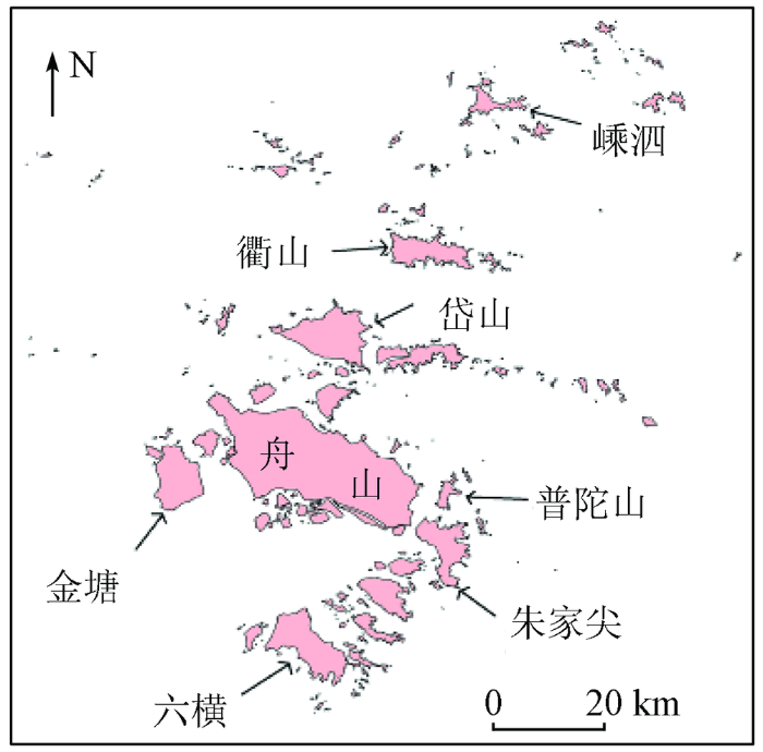
1.1 研究区概况
图1
1.2 数据源
本文选择中国科学院空天信息创新研究院(
表1 本文所用遥感数据情况
Tab.1
| 卫星 | 传感器 | 成像时间 | 卫星 | 传感器 | 成像时间 | |
|---|---|---|---|---|---|---|
| Landsat5 | TM | 2000.05.14,2000.06.06, 2003.08.27,2003.08.02, 2007.01.26,2006.04.20, 2009.08.27,2009.07.17, 2012.08.16,2012.11.17 | Landsat8 | OLI | 2015.04.22, 2015.03.12, 2018.06.01, 2018.07.26 |
2 研究方法
准确提取水体信息是实现海岸线精准监测的基础和关键。本研究针对悬浮泥沙、潮滩等导致传统水体信息提取方法精度较低、准确性较差的问题开展研究,基于缨帽变换在地物含水量表征方面的优势,提取长时间序列海岸线信息,开展海岸线时空演变分析。本研究技术路线如图2所示。
图2
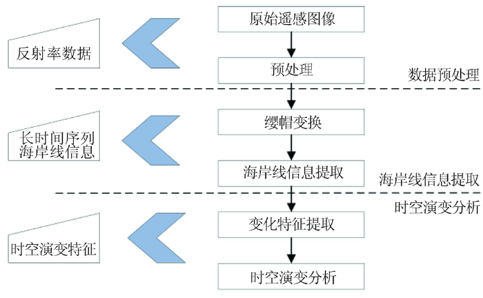
图3
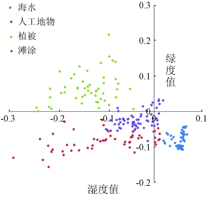
图3
典型地物缨帽变换特征空间图(绿度指数-湿度指数)
Fig.3
Scatter plot of typical feature in study area (greeness-wetness)
式中: Iw和Ig分别为缨帽变换后湿度指数和绿度指数; K为湿度指数特征值,通常情况下取0.025。
3 结果与分析
3.1 海岸线遥感信息提取
表2 海岸线遥感信息提取结果准确性评估
Tab.2
| 年份 | 生产者精度 | 用户精度 | 漏分误差 | 错分误差 |
|---|---|---|---|---|
| 2000年 | 86.82 | 89.30 | 13.18 | 10.70 |
| 2003年 | 95.89 | 98.10 | 4.11 | 1.90 |
| 2006年 | 95.74 | 98.02 | 4.26 | 1.98 |
| 2009年 | 93.55 | 98.42 | 6.45 | 1.58 |
| 2012年 | 93.47 | 97.52 | 6.53 | 2.48 |
| 2015年 | 93.69 | 95.42 | 6.31 | 4.58 |
| 2018年 | 96.21 | 96.26 | 3.79 | 3.74 |
| 平均值 | 93.62 | 96.15 | 6.38 | 3.85 |
生产者精度、用户精度、漏分误差和错分误差的平均值分别为93.62%,96.15%,6.38%和3.85%。这表明本文方法所获取海岸线信息较为准确,能够满足后续时空演变分析的要求,不仅所得结果在目视解译数据中占比较大,漏分误差较小,而且所得结果中正确提取的比例较高。
3.2 海岸线时空演变分析
图4
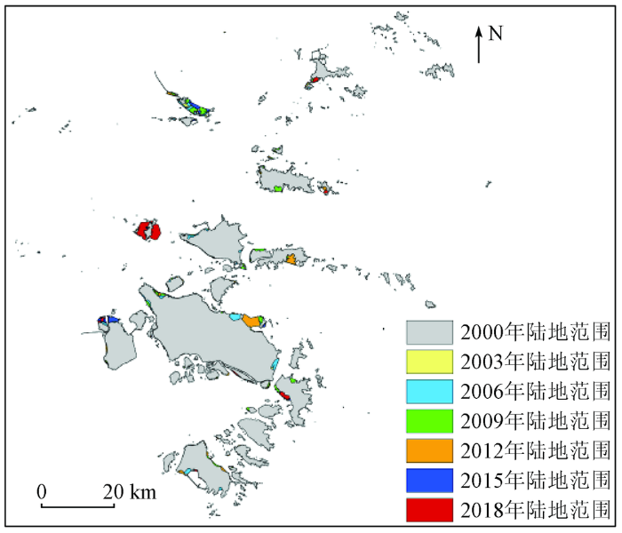
表3 各岛屿2000—2018年间的海岸线长度和面积统计
Tab.3
| 岛屿 | 长度/km | 面积/km2 | ||||||||||||
|---|---|---|---|---|---|---|---|---|---|---|---|---|---|---|
| 2000年 | 2003年 | 2006年 | 2009年 | 2012年 | 2015年 | 2018年 | 2000年 | 2003年 | 2006年 | 2009年 | 2012年 | 2015年 | 2018年 | |
| 舟山本岛 | 185.80 | 202.50 | 179.42 | 180.88 | 215.88 | 208.25 | 209.40 | 485.79 | 483.16 | 497.51 | 501.54 | 515.76 | 518.18 | 515.02 |
| 金塘 | 55.53 | 58.80 | 55.26 | 52.26 | 65.88 | 60.54 | 65.88 | 79.04 | 78.75 | 79.88 | 80.91 | 80.09 | 86.09 | 84.71 |
| 岱山 | 99.13 | 93.84 | 91.92 | 90.90 | 114.54 | 101.10 | 113.04 | 109.00 | 104.30 | 112.17 | 113.40 | 110.70 | 113.41 | 110.85 |
| 衢山 | 109.48 | 119.52 | 113.22 | 110.41 | 116.58 | 107.40 | 111.93 | 61.18 | 61.68 | 63.22 | 65.48 | 65.72 | 65.58 | 65.56 |
| 嵊泗 | 66.12 | 72.24 | 70.28 | 69.99 | 79.69 | 76.36 | 70.50 | 22.36 | 23.35 | 23.67 | 23.55 | 23.87 | 23.95 | 25.33 |
| 六横 | 100.31 | 104.65 | 104.34 | 101.40 | 115.47 | 122.71 | 134.84 | 97.42 | 95.01 | 100.22 | 101.79 | 105.03 | 105.47 | 106.54 |
| 朱家尖 | 92.41 | 93.18 | 92.46 | 93.47 | 99.32 | 104.82 | 98.58 | 62.00 | 62.41 | 63.35 | 65.39 | 65.80 | 65.78 | 68.47 |
| 桃花岛 | 59.46 | 63.66 | 63.12 | 63.84 | 62.70 | 62.16 | 62.88 | 41.99 | 41.05 | 41.62 | 41.24 | 41.24 | 41.16 | 41.37 |
| 秀山 | 40.07 | 43.26 | 40.68 | 42.48 | 43.08 | 43.08 | 48.00 | 24.27 | 23.36 | 24.44 | 24.56 | 24.42 | 24.31 | 24.14 |
| 其他岛屿 | 1 725.88 | 1 818.18 | 1 798.99 | 1 806.46 | 1 824.81 | 1 946.14 | 1 946.50 | 315.21 | 312.45 | 329.89 | 346.89 | 343.19 | 361.78 | 368.53 |
| 总计 | 2 534.19 | 2 669.83 | 2 609.69 | 2 612.09 | 2 737.95 | 2 832.56 | 2 861.55 | 1 298.26 | 1 285.52 | 1 335.97 | 1 364.75 | 1 375.82 | 1 405.71 | 1 410.52 |
3.2.1 时间演变特征分析
统计了不同年份的海岸线长度、长度变化、所围面积和面积变化,具体如图5所示。可以看出,舟山市海岸线总长度从2000年的2 534.19 km变化为2018年的2 861.55 km,增加了约327.36 km,年均增加长度为18.19 km/a,年均增长速率为0.72%,其中2000—2003年间和2009—2012年间增加较多,2003—2006年间出现减少。在面积方面,舟山市海岸线所围成的陆地面积从2000年的1 298.26 km2变化为2018年的1 410.52 km2,增加了约112.26 km2,年均增加面积为6.24 km2/a,年均增长速率为0.49%,其中2003—2006年增加较多,2000—2003年间出现减少。
图5
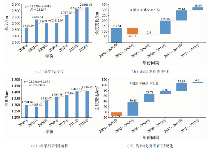
图5
2000—2018年间舟山市海岸线长度和面积变化
Fig.5
Changes of coastal line length and area in Zhoushan from 2000 to 2018
3.2.2 空间演变特征分析
通过分析发现,2000—2018年间海岸线变化最为明显的区域主要集中在舟山本岛、长峙岛及小干岛、朱家尖、嵊泗、岱山、渔山、衢山、洋山、六横等区域。
图6
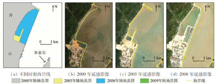
图6
2000—2018年间舟山本岛东港区域海岸线变化
Fig.6
Coastline change in Donggang of the Zhoushan island during 2000 to 2018
图7
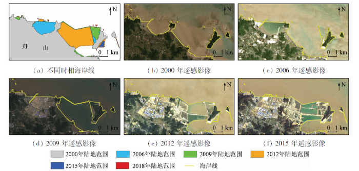
图7
2000—2018年间舟山本岛北蝉区域海岸线变化
Fig.7
Coastline change in Beichan of the Zhoushan island during 2000 to 2018
图8
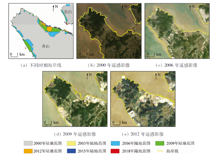
图8
2000—2018年间舟山本岛岑港区域海岸线变化
Fig.8
Coastline change in Cengang of the Zhoushan island during 2000 to 2018
2)长峙岛及小干岛。如图9所示,对于小干岛来说,海岸线变化主要是由于淤积和人工建设引起的,其中淤积发生在西北区域,使得原本分离的多个岛屿连接成为一个整体,人工建设使得海岸线由陆地向海扩张。对于长峙岛来说,大学园区的建设使得东部区域向外围成弧形海堤。
图9-1
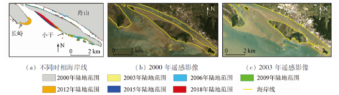
图9-1
2000—2018年间长峙岛及小干岛海岸线变化
Fig.9-1
Coastline change in Changzhi island and Xiaogan island during 2000 to 2018
图9-2
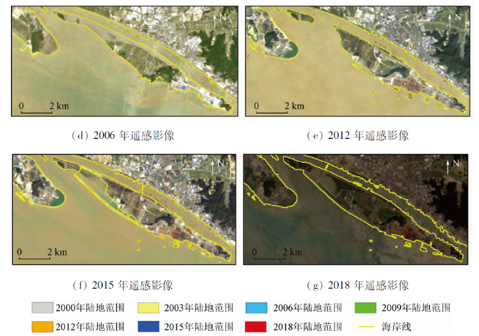
图9-2
2000—2018年间长峙岛及小干岛海岸线变化
Fig.9-2
Coastline change in Changzhi island and Xiaogan island during 2000 to 2018
3)朱家尖。2000—2018年间,朱家尖的海岸线变化情况如图10。2000—2009年间,由于海堤修建,海湾被填平,陆地区域向海扩张; 2009—2012年间,由于填海造陆,陆地区域向海扩张进一步加剧; 2012—2015年间,各处修建的海堤相互连接形成闭合; 2015—2018年间,围填海完成,形成完整的陆地区域。
图10
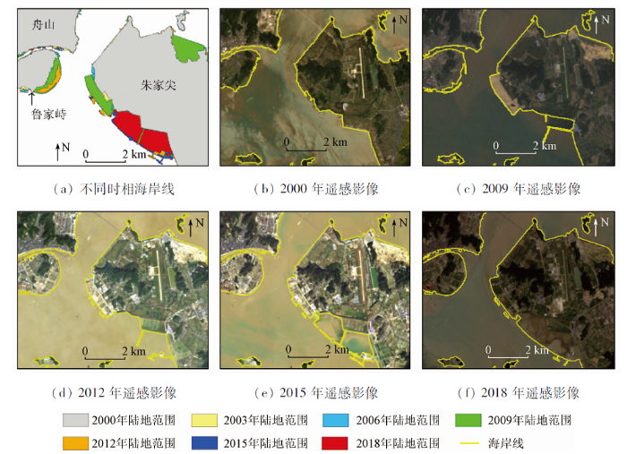
图10
2000—2018年间朱家尖海岸线变化
Fig.10
Coastline change in Zhujiajian island during 2000 to 2018
4)嵊泗。2000—2018年间,嵊泗的海岸线变化主要包括2种情况(图11): 一种是围填海,导致曲折的海湾自然海岸线变化为较短的直线型人工海岸线,如泗礁山岛和金鸡岛; 第二种是由海堤、桥梁将相邻岛屿连接,并同时建造码头,使得人工海岸线长度增加,如马迹岛。另外,剑门大桥和马迹门大桥的修建使得泗礁山岛、金鸡岛和马迹岛连接成为一个整体。
图11
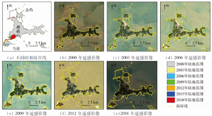
图11
2000—2018年间嵊泗海岸线变化
Fig.11
Coastline change in Shengsi island during 2000 to 2018
5)岱山。2000—2018年间,岱山的海岸线变化情况如图12所示。在岱山岛中部和大长涂岛南部区域,由于海堤的修建,海岸向陆凹进处逐渐形成闭合,使得曲折复杂岸线变得较为平直。另一方面,随着港口、码头等临海工程的建设,小长涂岛北部和东部的土地利用类型发生了较大变化,并持续向海扩张。
图12
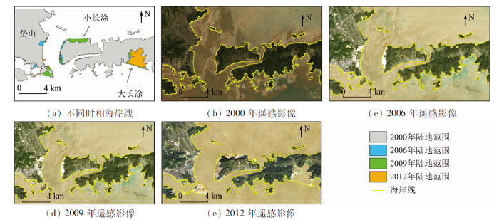
图12
2000—2018年间岱山海岸线变化
Fig.12
Coastline change in Daishan island during 2000 to 2018
6)鱼山。2000—2018年间,鱼山的海岸线变化情况如图13所示。2000—2015年间,海岸形态较
图13
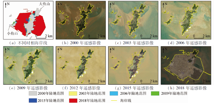
图13
2000—2018年间鱼山海岸线变化
Fig.13
Coastline change in Yushan island during 2000 to 2018
为稳定,以海水自然侵蚀和小规模人工建设为主。2015—2018年间,由于舟山绿色石化基地工程建设的开展,大鱼山和小鱼山的海岸线及岛屿形态发生了剧烈变化。
7)金塘。2000—2018年间,金塘的海岸线变化情况如图14所示。2000—2009年间,金塘岛的西南海湾处发生了填海造陆; 2009—2012年间,金塘岛的西边区域和东北区域的凹处被围海填平,西南海湾处继续由陆地向海扩张; 2012—2015年间,金塘岛和大鹏山岛的北部发生较为明显的围填海; 2015—2018年间,围填海完成,改变了海岸形态。
图14
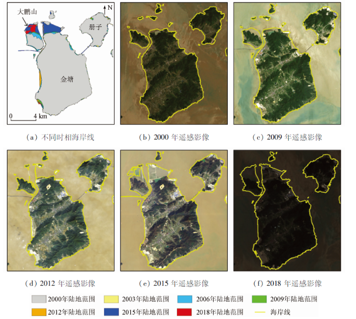
图14
2000—2018年间金塘海岸线变化
Fig.14
Coastline change in Jintang island during 2000 to 2018
8)衢山。2000—2018年间,衢山的海岸线变化情况如图15所示,主要发生在衢山岛、黄泽山、双子山、鼠浪湖等区域。其中,矿石中转码头项目的建设使得鼠浪湖岛土地利用类型发生了较大变化,并持续向海扩张; 衢山岛南边修建了海堤,使得海湾封闭,改变了原始海岸形态。
图15
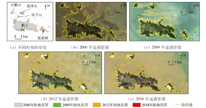
图15
2000—2018年间衢山海岸线变化
Fig.15
Coastline change in Qushan island during 2000 to 2018
9)洋山。2000—2018年间,洋山的海岸线变化情况如图16所示。在研究期间内,洋山水深港区的开发建设使得小洋山岛和大乌龟岛的土地利用类型发生较大变化,并且围填海工程使得小洋山岛与周围几个面积较小的岛屿连接成为一个整体; 在大洋山岛,围垦工程使得海岸线向海扩张,岛屿陆地面积持续增加。
图16
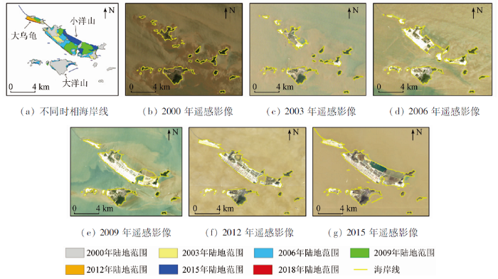
图16
2000—2018年间洋山海岸线变化
Fig.16
Coastline Change in Yangshan during 2000 to 2018
10)六横。2000—2018年间,六横的海岸线变化情况如图17所示。在研究期间内,船舶修造、临港石化、港口物流等临港产业的发展使得沿岸滩涂被围垦作为建设用地,海岸线不断由陆地向海扩展。另一方面,海堤、港口、码头等设施的修建使得原本开阔的海湾封闭。
图17
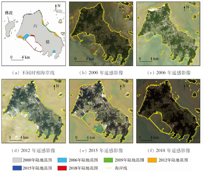
图17
2000—2018年间六横海岸线变化
Fig.17
Coastline change in Liuheng island during 2000 to 2018
4 结论与讨论
在分析传统海岸线遥感信息提取算法的基础上,针对高悬浮泥沙含量水域、滩涂等区域开展研究,考虑不同地物在含水量方面的差异,发展了基于缨帽变换的海岸线遥感信息提取方法,并基于长时间序列卫星遥感数据,分析海岸线时空演变。主要结论如下:
1)本文方法能够准确提取复杂海洋环境下的海岸线信息,生产者精度、用户精度、漏分误差和错分误差的平均值分别为93.62%,96.15%,6.38%和3.85%; 海岸线长度从2000年的2 534.19 km变化为2018年的2 861.55 km,年均增加长度为18.19 km/a,年均增长率为0.72%; 海岸线所围成的陆地面积从2000年的1 298.26 km2变化为2018年的1 410.52 km2,增加了约112.26 km2,年均增加面积为6.24 km2/a,年均增长速率为0.49%。
2)舟山群岛区域海岸线和海岸形态变化主要集中在舟山本岛、长峙岛及小干岛、朱家尖、嵊泗、岱山、渔山、衢山、洋山、六横等区域,围填海和临海工程建设使得较多的自然海岸线变化为人工海岸线,海岸线形态也由曲折复杂变化为平直。
本研究虽然准确提取了高悬浮泥沙含量水域、滩涂区域的海岸线信息,并开展了时空演变分析,但仍然存在一些问题需要未来进一步开展研究: ①结合高精度的区域地形数据和潮位数据,开展潮汐校正,获取空间位置更加准确的海岸线信息; ②构建海岸线时空演变定量分析指标体系,明确海岸线总体进退情况和空间差异。
参考文献
遥感影像的海岸线自动提取方法研究进展
[J].
Research progress on methods of automatic coastline extraction based on remote sensing images
[J].
Dynamic process and artificial mechanism of coastline change in the Pearl River Estuary
[J].DOI:10.1016/j.rsma.2019.100715 URL [本文引用: 1]
Mapping changes in coastlines and tidal flats in developing islands using the full time series of Landsat images
[J].DOI:10.1016/j.rse.2020.111665 URL [本文引用: 1]
Using GPS-surveyed intertidal zones to determine the validity of shorelines automatically mapped by Landsat water indices
[J].DOI:10.1016/j.jag.2017.10.007 URL [本文引用: 1]
基于遥感影像的海岸线提取方法综述
[J].
DOI:10.12082/dqxxkx.2018.180152
[本文引用: 1]

近年来,全球气候变暖等原因导致海平面不断升高,人类对海岸带的开发也越来越频繁,海岸带的变化比以前更为活跃,因此精确快速地提取出海岸线并实时监测其变化对我国海岸带的开发规划与利用具有重要的意义。本文详细梳理了国内外利用光学遥感、微波遥感和雷达遥感手段提取瞬时水边线或理论海岸线的方法,对各种经典方法和一些近年来出现的新方法进行了分析和比较,并指出各种方法的适用情况和不足。最后,针对目前中国在此方面的研究现状给出了一些建议。
Review of coastline extraction methods based on remote sensing images
[J].
我国海岸带海岛礁遥感研究进展及建议
[J].
Remote sensing application in China’s coastal zones and islands:Recent progress and some suggestions
[J].
Evaluation of annual mean shoreline position deduced from Landsat imagery as a mid-term coastal evolution indicator
[J].DOI:10.1016/j.margeo.2015.12.015 URL [本文引用: 1]
围填海影响下东海区主要海湾形态时空演变
[J].
DOI:10.11821/dlxb202001010
[本文引用: 1]
围填海影响下海湾形态变化能够深刻反映人类活动对海湾自然环境的影响程度,分析海湾形态变化对合理高效地利用与保护海湾资源具有重要意义。研究以东海区12个主要海湾(包括陆域与水域)为研究区,基于20世纪90年代以来6个时期的Landsat TM/OLI遥感影像数据,通过海湾岸线与湾面形态分析东海区主要海湾的变化特征,探讨围填海强度与海湾形态变化之间的相关性。主要结论为:① 1990—2015年,东海区主要海湾岸线总长度共波动增长66.65 km,2005—2010年间海湾开发最活跃,阶段内岸线增长量达38 km。岸线长度三沙湾最大(439 km),泉州湾最小(105 km);兴化湾增长最多(54.53 km),罗源湾缩短最多(25.75 km)。自然岸线与人工岸线长度此消彼长,岸线人工化程度不断加强,东海北部海湾岸线总长度大于南部海湾。② 1990—2015年,东海区海湾岸线共向海推进26.93 km,合1.08 km/a,在1995—2000年及2005—2010年间推进最多,分别达7.10 km和 6.00 km,在1990—1995年间推进量最小,为2.97 km。杭州湾(4.93 km)和兴化湾(4.15 km)岸线向海推进距离最长,厦门湾推进(0.55 km)最短;东海南部海湾岸线迁移量平缓,北部海湾则更为剧烈,是东海区岸线迁移变化的主体。③ 1990—2015年间东海区主要海湾水域总面积由初期的13.85 km2减少至12.29 km2,累积减少11.23 %,海湾形状不断向复杂化演变。其中杭州湾海湾水域面积减少量最多,达到0.726 km2,占研究区的46.69 %。空间上,北部海湾水域面积减少量更大,而南部海湾水域面积减小速率更快。④ 1990年以来,东海区主要海湾人工化指数平均值和岸线开发强度指数均有所上涨,21世纪以来的开发利用度显著提高。南部(闽)海湾的开发利用程度较北部(浙沪)更为深入,北部海湾开发强度的年际波动差异更大。海湾开发强度与海湾岸线长度、人工岸线长度、海湾形态指数呈正相关关系,与自然岸线长度、海湾水域面积呈负相关关系。当海湾开发强度增加时,同时段内海湾围填海活动的强度也显著增加。
Spatial and temporal evolutions of the major bays in the East China Sea under the influence of reclamataion
[J].
海南岛海岸线变迁遥感监测与分析
[J].
Coastline change detection and analysis with remote sensing in Hainan Island
[J].
海岸线变化研究综述
[J].
Review of research on coastline changes
[J].
Correntropy-based sparse spectral clustering for hyperspectral band selection
[J].DOI:10.1109/LGRS.8859 URL [本文引用: 1]
Lateral-slice sparse tensor robust principal component analysis for hyperspectral image classification
[J].DOI:10.1109/LGRS.8859 URL [本文引用: 1]
中国地球观测遥感卫星发展现状及文献分析
[J].
Development status and literature analysis of China’s earth observation remote sensing satellites
[J].
遥感大数据时代与智能信息提取
[J].
Remotely sensed big data era and intelligent information extraction
[J].
Coastline extraction from repeat high resolution satellite imagery
[J].DOI:10.1016/j.rse.2019.04.010 URL [本文引用: 1]
Extracting the intertidal extent and topography of the Australian coastline from a 28 year time series of Landsat observations
[J].DOI:10.1016/j.rse.2017.04.009 URL [本文引用: 1]
Monitoring the coastline change of Hatiya island in Bangladesh using remote sensing techniques
[J].DOI:10.1016/j.isprsjprs.2014.12.009 URL [本文引用: 1]
Continuous monitoring of coastline dynamics in Western Florida with a 30-year time series of Landsat imagery
[J].DOI:10.1016/j.rse.2016.03.031 URL [本文引用: 1]
Analysis of coastline changes and the socio-economic driving mechanisms in Shenzhen,China
[J].DOI:10.1080/01490419.2017.1319447 URL [本文引用: 1]
Spatio-temporal characteristics of the mainland coastline utilization degree over the last 70 years in China
[J].
2010—2017年珠江河口海岸线遥感监测和动态变化分析
[J].
Remote sensing monitoring and dynamic analysis of the Pearl River Estuary coastline during 2010—2017
[J].
High-resolution depth and coastline over major atolls of South China Sea from satellite altimetry and imagery
[J].DOI:10.1016/j.rse.2016.01.016 URL [本文引用: 1]
Hurricane-induced shoreline change and post-storm recovery:Northeastern Yucatan Peninsula,Mexico
[J].DOI:10.2112/SI75-239.1 URL [本文引用: 1]
Characteristics of coastline changes in Mainland China since the early 1940s
[J].DOI:10.1007/s11430-016-5317-5 URL [本文引用: 1]
Coastline extraction using high resolution WorldView-2 satellite imagery
[J].DOI:10.5721/EuJRS20144739 URL [本文引用: 1]
Assessing the impacts of shoreline hardening on beach response to hurricanes:Saint-Barthélemy,Lesser Antilles
[J].
Historical monitoring of shoreline changes in the Cua Dai Estuary,Central Vietnam using multi-temporal remote sensing data
[J].
Evaluating urban heat island intensity and its associated determinants of towns and cities continuum in the Yangtze River Delta urban agglomerations
[J].DOI:10.1016/j.scs.2019.101659 URL [本文引用: 1]
Quantitative analysis of erosion and accretion (1975—2017) using DSAS:A study on Indian Sundarbans
[J].DOI:10.1016/j.rsma.2019.100583 URL [本文引用: 1]
Geometric deep learning:Going beyond euclidean data
[J].
Spatiotemporal change patterns of coastlines in Zhejiang Province,China,over the last twenty-five years
[J].DOI:10.3390/su10020477 URL [本文引用: 1]
A coastline detection method in polarimetric SAR images mixing the region-based and edge-based active contour models
[J].DOI:10.1109/TGRS.2017.2679112 URL [本文引用: 1]
基于样本自动选择与SVM结合的海岸线遥感自动提取
[J].
Automatic extraction of coastline by remote sensing technology based on SVM and auto-selection of training samples
[J].
基于多时相GF-1和Landsat影像的连云港市44年海岸线遥感监测与演变分析
[J].
Remote sensing monitoring and evolution analysis of the coastline in the Lianyungang City based on multi-temporal GF-1 and Landsat images during 44 years
[J].
Combining series of multi-source high spatial resolution remote sensing datasets for the detection of shoreline displacement rates and the effectiveness of coastal zone protection measures
[J].DOI:10.1007/s11852-018-0591-3 URL [本文引用: 1]
Impacts of coastal reclamation on wetlands:Loss,resilience,and sustainable management
[J].DOI:10.1016/j.ecss.2018.06.013 URL [本文引用: 1]
Significant coastline changes in China during 1991—2015 tracked by Landsat data
[J].DOI:10.1016/j.scib.2018.05.032 URL [本文引用: 1]
Comparative research on the impact of human activities on changes in coastline and landscape in bay areas:A case study with Xiangshangang bay,China and Tampa bay,USA
[J].
The role of environmental impact assessment in protecting coastal and marine environments in rapidly developing islands:The case of Bahrain,Arabian Gulf
[J].
基于缨帽变换的农田洪水淹没范围遥感信息提取
[J].
A method of flood submerging area extracting for farmland based on tasseled cap transformation from remote sensing images
[J].
剖面形态自适应的海岸线遥感推算方法
[J].
Remote sensing prediction method of coastline based on self-adaptive profile morphology
[J].
基于遥感数据的舟山市土地利用时空格局研究
[J].
Research on spatial-temporal pattern of land use in Zhoushan City by using remote sensing images
[J].
55-year (1960—2015) spatiotemporal shoreline change analysis using historical DISP and Landsat time series data in Shanghai
[J].DOI:10.1016/j.jag.2018.02.009 URL [本文引用: 1]
Remote sensed big data:Evolution in model development for information extraction
[J].
DOI:10.1109/JPROC.2019.2948454
[本文引用: 1]
Since the 1960s, remote sensing (as an innovative, comprehensive, and interdisciplinary academic area) has been adopted in a wide range of disciplines related to Earth observation, including hydrology, ecology, oceanography, glaciology, geology, military, intelligence, business, economy, and planning [1]-[3]. The constant development of the remote sensing image acquisition technology now allows for the collection of a wide variety of images with different characteristics and resolutions, obtained by remote sensing instruments mounted on spacecraft or aircraft platforms. These images record some type of signal or energy measured from the Earth's surface, which depends on the type of sensor used.
Drivers,trends,and potential impacts of long-term coastal reclamation in China from 1985 to 2010
[J].DOI:10.1016/j.ecss.2016.01.006 URL [本文引用: 1]
Application of remote sensing and GIS for detection of long-term mangrove shoreline changes in Mui Ca Mau,Vietnam
[J].DOI:10.5194/bg-11-3781-2014 URL [本文引用: 1]
中国东海区大陆海岸线变迁及其开发利用强度分析
[J].
The changes of continental coastline and its development and utilization intensity in the East China Sea
[J].
The application of the tasseled cap transformation and feature knowledge for the extraction of coastline information from remote sensing images
[J].DOI:10.1016/j.asr.2019.07.032 URL [本文引用: 1]
Coastline information extraction based on the tasseled cap transformation of Landsat-8 OLI images
[J].DOI:10.1016/j.ecss.2018.10.021 URL [本文引用: 1]
