

0 引言
大型海藻养殖是海水养殖的重要组成部分,主要分布在我国东部沿海地区,包括江苏、福建、浙江、辽宁和山东等地[1-2]。我国的大型海藻养殖种类众多,主要有紫菜、海带和裙带菜等[3]。海藻不仅具有巨大经济价值,亦具有调节大气、净化水质和固碳等生态功能[4]。然而,海藻养殖不当也会产生环境危害,已有研究显示,我国近海的海洋大型藻等灾害与海藻养殖有着密切的联系[5-6]。开展藻类养殖区的动态监测,不仅可以掌握养殖区的动态变化特征,还可以辅助分析周围水环境的变化,为相关海洋灾害的产生机理研究提供基础数据。山东半岛,特别是威海市沿岸,是我国北方最重要的海藻养殖基地之一。近年,受市场对养殖品种的需求、海水环境与灾害等因素影响,威海市近海的海藻养殖品种与空间布局正发生深刻变化。对本地区海藻养殖动态进行监测,对其管理及灾害应对有重要的现实意义。
卫星遥感具有周期短、范围大、观测连续等优势,可以提供传统调查不具备的精细化空间信息[5-6]。国内外众多学者利用遥感影像对大型海藻养殖展开了广泛研究。在海藻养殖区的提取方法上,目前主要有人工目视解译、归一化植被指数(normalized difference vegetation index,NDVI)阈值法、最大似然分类、支持向量机(support vector machine,SVM)与面向对象分类等[2,5⇓⇓⇓⇓ -10]。武易天等[11]提出了一种耦合光谱与纹理信息的近海藻类养殖区自动提取方法; Won等[12]提出了一种基于极化熵信息的水下紫菜养殖区提取方法。在提取水色背景相对稳定的大型海藻养殖区时,NDVI阈值法的监测效果较好[8]。但当海水中混有大量悬浮泥沙、水色背景较复杂时,相比NDVI阈值法,SVM有更高的监测精度[8,10,13]。在大型海藻养殖的遥感动态监测上,国内学者研究较多,而国外目前相关研究较少。Xing等[6]对苏北浅滩的紫菜养殖动态进行了长时序精细化的遥感监测,获取了紫菜养殖年际变化以及每年的养殖设施回收进程的时空动态特征,并阐明了其对黄海浒苔绿潮的影响; 郭瑞宏[9]基于Landsat卫星的时序数据,分析了江苏省紫菜养殖区的年际变化特征; Lu等[14]利用4期Landsat影像,对连云港紫菜养殖区的空间变化特征展开研究; 曹万云[15]利用遥感影像与海带产量数据,分析了荣成市海带养殖的时空变化特征等。但是上述研究仅针对一种藻类养殖进行动态监测,缺乏不同类型大型海藻养殖的对比监测,且山东沿海的紫菜养殖动态研究鲜有报道。
因此,本文基于Sentinel-2卫星影像,结合目前较常用的NDVI与SVM方法提取山东省威海市文登区南部海域紫菜养殖区与荣成市典型海域海带养殖区信息,分析紫菜养殖的年际变化,并对比紫菜与海带养殖的季节变化特征。
1 研究区概况
图1
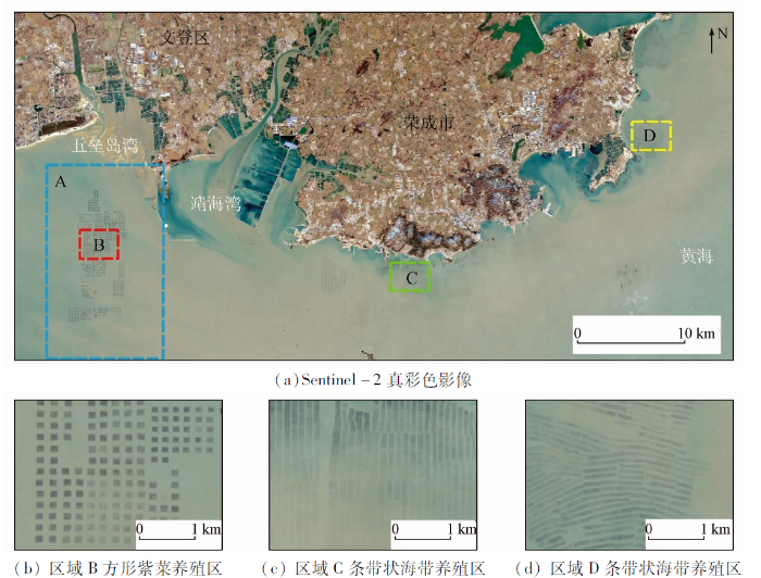
图1
研究区地理位置及大型藻类养殖区分布
Fig.1
Geographical location of the study area and distribution of macroalgae cultivation areas
2 数据源
本文以Sentinel-2卫星影像为基础数据,数据在欧洲航空局官网(
表1 所用影像介绍
Tab.1
| 年份 | 影像日期 |
|---|---|
| 2016年 | 01-25,03-25,04-24,05-04,07-13,08-22, 09-11,11-20,12-10 |
| 2017年 | 01-09,03-10,04-19,05-19,08-02,09-11, 09-21,10-21,11-15,12-05 |
| 2018年 | 01-09,02-13,03-25,04-19,05-04,06-03, 08-02,10-21,11-10,11-30 |
| 2019年 | 01-24,02-23,03-25,04-14,06-23,08-17, 09-26,10-31,11-20,12-20 |
| 2020年 | 01-14,02-23,03-24,04-03,06-22,07-02, 09-20,10-25,11-09,12-19 |
| 2021年 | 01-18,02-02,03-24,04-18,05-18,07-22 |
3 研究方法
本文技术路线如图2所示,数据预处理主要有辐射定标、大气校正和影像裁剪等,提取后处理包括面积筛选与人工修正。其中,大气校正使用欧洲航空局提供的Sen2cor插件进行。
图2

图3

图3
样本分布及相应的光谱曲线与NDVI频率分布
Fig.3
Distribution and corresponding spectral curve of samples and frequency distribution of NDVI
式中
在监测结果的精度评价中,分别目视选取养殖区与非养殖区验证样本,各2 000个像元,计算混淆矩阵,利用总体分类精度(overall accuracy,OA)与Kappa系数进行评价。每个季节选一景进行评价,选取2019年1月、4月、6月和10月的紫菜与海带养殖区的遥感监测结果进行精度评价。
4 结果与分析
4.1 监测结果与精度评价
图1(a)中区域A范围中紫菜养殖的年度遥感监测结果如图4所示。紫菜的年度养殖方与年度监测面积,由前一年下半年下苗和第二年上半年的收割构成的一个养殖周期内的各期结果合并而成,如2017年度的紫菜养殖周期为2016年7月—2017年6月。文登区南部海域的紫菜养殖块呈方形,与江苏连云港的紫菜养殖方形状类似; 整体上,紫菜养殖区在五垒岛湾近海呈南北向分布,南北向跨度大,东西向跨度小。海带养殖区的监测结果如图5所示(仅展示2020年2月23日的监测结果,此时海带养殖的监测面积达2020年最大),荣成市南部海域的海带养殖呈条带状,紧沿岸边分布。通过目视观测,整体上遥感提取的紫菜与海带养殖区可以较好地覆盖底图显示的养殖方与养殖条带。
图4

图4
2017—2021年度紫菜养殖区的遥感监测结果
Fig.4
Remote sensing monitoring results of Porphyra aquaculture during 2017—2021
图5
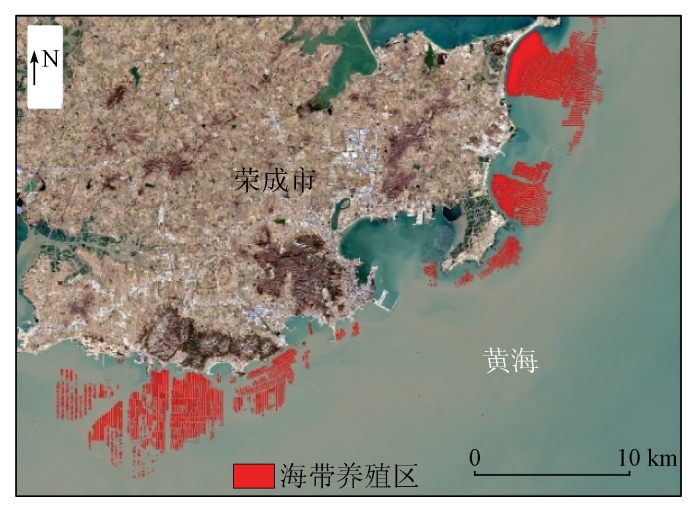
图5
2020年2月23日海带养殖区的遥感监测结果
Fig.5
Remote sensing monitoring results of kelp farming areas on February 23, 2020
图6

图6
遥感监测的紫菜养殖区面积与养殖方个数变化
Fig.6
Changes of the area of Porphyra aquaculture and the number of cultivation squares monitored by remote sensing
基于验证样本计算OA与Kappa系数,计算结果如表2所示。针对4期紫菜养殖区的遥感监测结果,本文紫菜养殖区的OA均大于92%,Kappa系数均大于0.84。针对4期海带养殖区的监测结果,OA均大于84%,除2019年10月31日外,其余3期海带养殖区的Kappa系数均大于0.88。
表2 精度评价结果
Tab.2
| 指标 | 紫菜养殖区 | 海带养殖区 | ||||||
|---|---|---|---|---|---|---|---|---|
| 2019-01-24 | 2019-04-14 | 2019-06-23 | 2019-10-31 | 2019-01-24 | 2019-04-14 | 2019-06-23 | 2019-10-31 | |
| OA/% | 99 | 99 | 92 | 95 | 94 | 94 | 95 | 84 |
| Kappa | 0.99 | 0.97 | 0.84 | 0.89 | 0.87 | 0.88 | 0.90 | 0.68 |
4.2 紫菜养殖年际变化
遥感监测的紫菜养殖区面积与养殖方个数如图6所示,2016—2021年,文登区紫菜养殖监测面积的逐月变化具有明显的周期性,每个周期内的遥感监测面积先增后减,故将每一养殖周期定义为一个养殖年度。文登区自2017年度开展养殖紫菜,2018年度便大幅增加,其后呈逐年增加趋势。2021年度紫菜养殖的监测面积比2017年度约多10.36 km2,养殖方个数多656个。2017—2018年度紫菜养殖的监测面积与养殖方个数变化最大; 在2018年以后,面积与养殖方数目的变化速率均减小,2019—2020年度变化最小。在空间上,如图4所示,2017—2021年度紫菜养殖的空间分布整体上逐渐变大,且变化明显,其中2017—2018年度变化最大,2018—2019年度与2020—2021年度变化相对较小。文登区自开始养殖紫菜,养殖区域呈先向岸扩展后离岸扩展。
4.3 紫菜与海带养殖季节变化
图7

图7
紫菜养殖遥感监测面积的季节变化
Fig.7
Seasonal changes of Porphyra culture monitoring area by remote sensing
选取2019年与2020年的1—12月的遥感影像,每月选用一景,开展紫菜与海带养殖区的对比监测,养殖区监测面积的逐月变化如图8(a)所示。在2019—2020年,紫菜养殖的监测面积分别于2019年8月17日、2020年7月2日出现极小值。在2019年10月31日和2020年9月20日,海带养殖的监测面积处于极小值,面积分别约为0.84 km2和0.7 km2。可以发现,紫菜养殖监测面积的极小值出现的时间比海带的大致早2个月。在2019—2020年,紫菜养殖的监测面积于2019年4月14日和2019年12月20日出现极大值,海带养殖的监测面积于2019年6月23和2020年2月23日出现极大值。可见紫菜养殖监测面积的极大值出现的时间也比海带的大致早2个月。
图8
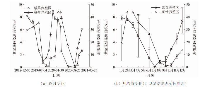
图8
2019—2020年紫菜与海带养殖的监测面积变化
Fig.8
Changes of the monitoring area of Porphyra and kelp culture from 2019 to 2020
上述表明,在同一养殖周期中,紫菜养殖监测面积的最大值出现在冬季,而海带养殖出现在初春; 紫菜养殖监测面积的最小值出现在夏季,而海带养殖出现在秋季。整体而言,紫菜养殖监测面积最大值与最小值出现的时间比海带的早1~2个月。
4.4 与统计年鉴数据的对比分析
统计年鉴中紫菜与海带养殖面积的统计结果如图9所示。
图9

图9
2015—2020年统计年鉴中紫菜与海带的养殖面积变化
Fig.9
Changes of the cultivation area of Porphyra and kelp in statistical yearbook during 2015—2020
对比图6(b)与图9(a)发现,整体上,紫菜年度养殖面积在遥感监测与统计年鉴中均呈现增加趋势。紫菜养殖面积的大幅度变化在本文遥感监测的结果中出现在2017—2018年度,而在统计年鉴中出现在2016—2017年; 这是因为统计年鉴中的紫菜年度养殖是由每年1—12月份的紫菜养殖组成,其与本文所定义的紫菜年度养殖不同。如图8(a)与图9(b)所示,本文遥感监测的荣成市部分海域的海带养殖面积整体变化不明显,同样统计年鉴中2015—2020年荣成市的海带养殖面积整体变化也不明显。此外,图9显示,威海市的紫菜养殖面积约占山东省总养殖面积的80%,海带养殖面积约占山东省总养殖面积的60%; 威海市的紫菜养殖均在文登区,而海带养殖均在荣成市,紫菜与海带养殖面积变化与山东省的总养殖面积变化基本一致。针对养殖周期跨年的大型海藻养殖,统计年鉴按日历周期进行统计会导致时间信息不明确。由图7可知,遥感能提供精细的季节变化特征,可实现按养殖周期进行结果统计与分析; 并且,遥感能提供精准的空间信息,可对养殖区大型海藻生长的空间差异进行即时评估。如前所述,考虑到研究区的紫菜与海带养殖在山东省占主要比重,基于遥感的监测结果对威海市及山东省的紫菜与海带养殖状态有更好的指示作用。
5 结论与展望
本研究基于Sentinel-2卫星数据,采用NDVI阈值法和SVM方法对威海市文登区南部海域的紫菜养殖区以及荣成市南部海域的海带养殖区的动态进行了对比监测。研究发现并证实了,威海市及山东省紫菜养殖的大幅增加主要源于2016年秋季开始的威海市文登区南海海域的紫菜养殖扩张; 研究区的紫菜与海带养殖区遥感监测面积均呈冬高夏低的周期性变化特征,紫菜养殖遥感监测结果的变化周期较海带早1~2个月。
卫星遥感数据能提供紫菜与海带养殖精准的生长期时空动态数据,可以弥补统计年鉴数据时间、空间信息不全的不足,这对威海市乃至山东省的大型海藻养殖管理有重要参考价值。在大型海藻养殖区遥感提取的基础上,可进一步利用遥感监测估算其生长状态及生物量,结合海温、水质等遥感监测对海藻产量及可能的灾害进行预警评估。
参考文献
中国经济海藻养殖技术概况与展望
[J].
DOI:10.13304/j.nykjdb.2019.0795
[本文引用: 1]

我国是全球海藻生产和消费大国。当前,我国海藻养殖种类以海带、紫菜、江蓠和裙带菜等为主体,兼有小规模养殖的羊栖菜、鼠尾藻、麒麟菜、石花菜、礁膜、浒苔、长茎葡萄蕨藻等。海藻养殖方式包括浅海养殖、潮间带养殖和陆基养殖。近年来,在全球气候变化、海水污染、海岸工程等多重压力下,海藻养殖环境不佳,养殖病害多发;另外,海洋生态文明建设大背景下的近海水域利用政策变化,对海藻养殖产业及其养殖技术提出了新的要求与挑战。对我国海藻养殖技术进行回顾,总结经验、查找不足,提出新思路、新方法,以期为我国海藻养殖产业可持续发展提供支撑。
Overview and prospects of China economic seaweed cultivation technology
[J].
DOI:10.13304/j.nykjdb.2019.0795
[本文引用: 1]
China is a large seaweed production and consumption country in the world. At present, farmed seaweed species in China mainly include Saccharina spp., Pyropia spp., Gracilaria spp. and Undaria pinnatifida. There are also small-scale cultivated species, Sargassum spp., Eucheuma spp., Kappaphycus spp., Gelidium spp., Ulva spp. and Caulerpa spp.. There are three types of seaweed farming model including shallow sea farming, intertidal farming and land-based farming. In recent years, under the multiple pressures of global climate change, seawater pollution and coastal engineering, the physical cultivation environment in which these seaweeds are farmed has deteriorated and diseases have occurred rather frequently. In addition, the policy of shallow sea usage in the context of marine ecological civilization construction has changed. This change puts forward new demands and challenges for the seaweed farming industry, calling for updated techniques and models. This paper reviewed the current seaweed cultivation in general in China, summarized the experience, found the deficiency, and proposed new ideas and methods to provide support for the sustainable development of seaweed cultivation industry in the future.
连云港近海紫菜养殖区遥感识别、空间变异和驱动分析
[J].
The identification of Porphyra culture area by remote sensing and spatial distribution change and driving factors analysis
[J]
我国藻类产业发展现状、问题及对策建议
[J].
DOI:10.13304/j.nykjdb.2019.0896
[本文引用: 1]
我国是藻类生产、消费和贸易大国,藻类产业作为国家战略产业的重要组成部分,既面临着许多发展新机遇,也存在众多亟待解决的问题。首先梳理了我国藻类养殖、加工、贸易和消费现状,然后根据调研数据对消费者的需求特征进行了深入分析。结果显示:我国藻类养殖产量和面积呈上升趋势,各藻类细分品种产量不均。同时,藻类加工产品日益丰富,贸易优势明显,但藻类从业者收入较低。消费者对藻类产品了解程度虽然较低,但并不排斥藻类产品。藻类产品的包装、品牌建设较差,营养安全是消费者食用藻类产品的主要原因。基于此,指出了我国藻类发展过程中存在的主要问题与矛盾。最后以供给侧改革为主线,从政策、科技、市场、消费文化、劳动力、生产组织结构和贸易方面分别阐述了振兴藻类产业的对策建议。
Current status,problems and countermeasures of algae industry development in China
[J].
中国近海藻类养殖生态价值评估初探
[J].
Initial assessment of seaweed farming ecological value in coastal waters of China
[J].
基于遥感的2000—2015年南黄海紫菜养殖空间分布变化研究
[J].
Study on the spatial distribution variation of Porphyra aquaculture in the southern Yellow Sea during the period 2000—2015 retrieved by satellite remote sensing
[J].
Monitoring seaweed aquaculture in the Yellow Sea with multiple sensors for managing the disaster of macroalgal blooms
[J].DOI:10.1016/j.rse.2019.111279 URL [本文引用: 4]
南黄海绿潮暴发与紫菜养殖的关系
[J].
Research on the relations between green tide and Porphyra cultivation in the south Yellow Sea
[J].
基于SR-NDVI和中值滤波的连云港海域紫菜筏架自动提取研究
[J].
Research on the automatic extraction of floating raft aquaculture based on SR-NDVI and median filtering in Lianyungang
[J].
高分一号的浮筏养殖信息提取方法
[J].
Information extraction of floating raft aquaculture based on GF-1
[J].
基于Landsat8数据的近海养殖区自动提取方法研究
[J].
Research on automatic extraction method for coastal aquaculture area using Landsat8 data
[J].
Extraction of underwater laver cultivation nets by SAR polarimetric entropy
[J].DOI:10.1109/LGRS.2012.2199077 URL [本文引用: 1]
基于哨兵二号遥感影像的近海养殖区提取方法研究
[J].
Research on extraction method of offshore aquaculture area based on Sentinel-2 remote sensing imagery
[J].
Spatial change analysis of Porphyra yezoensis aquaculture in the Lianyungang coastal area by the use of remote sensing and geographic information system technology
[J].DOI:10.1007/s12524-019-00987-7 [本文引用: 1]
威海海洋食品又添新品文登千亩紫菜收割上市
[EB/OL].(2017-01-10)[2022-02-24]. http://www.hellosea.net/Product/7/2017-01-10/35877.html?cktove=ayvg03.
Weihai seafood has added new products Wendeng thousand Mu seaweed harvested and listed
[EB/OL].(2017-01-10)[2022-02-24]. http://www.hellosea.net/Product/7/2017-01-10/35877.html?cktove=ayvg03.
条斑紫菜(Porphyra yezoensis)的颜色和色素
[J].
Color and pigment of Porphyra yezoensis
[J].
基于QUEST决策树的遥感影像土地利用分类——以云南省丽江市为例
[J].
Research on the accuracy of TM images land-use classification based on QUEST decision tree: A case study of Lijiang in Yunnan
[J].
DOI:10.11821/yj2012110005
[本文引用: 1]
The accuracy of research on land use/cover change (LUCC) is determined directly by the accuracy of land use classification derived from aerial and satellite images.In analysis of the factors of accuracy of current remote sensing image classification, some methods were introduced to study new trends of classification modes.Some previous studies showed that the speed and accuracy of QUEST (Quick, Unbiased, and Efficient Statistical Tree) decision tree classification were superior to those of other decision tree classifications. On the basis of this approach, the research classified the Landsat TM-5 images in Lijiang, Yunnan province.This paper compared the result with that of maximum likelihood image classification.The overall accuracy was 90.086%, which was higher than the overall accuracy (85.965%) of CART (Classification And Regression Tree).Meanwhile, the Kappa efficient was 0.849, which was higher than the Kappa efficient (0.760) of CART. Therefore, it is concluded that in the complex terrain area such as in mountainous regions, the choice of QUEST decision tree classification on TM image would improve the accuracy of land use classification. This type of classification decision tree can precisely obtain new classification rules from integrated satellite images, land use thematic maps, DEM maps and other field investigation materials.Simultaneously, the method can also help users to find new classification rules in multidimensional information, and to build decision tree classifier models. Furthermore, the methods, including a large number of high-resolution and hyperspectral image data, integrated multi-sensor platform, multi-temporal remote sensing image, the pattern recognition and data mining of spectral and texture features, and auxiliary geographic data, will become a trend
