Satellite remote sensing-assisted comparative monitoring of dynamic characteristics of macroalgae aquaculture in Weihai City, Shandong Province, China
HOU Yingzhuo1,2,3(), JI Ling4, XING Qianguo1,2,3(), SHENG Dezhi1,2,3
1. CAS Key Laboratory of Coastal Environmental Processes and Ecological Remediation, Yantai Institute of Coastal Zone Research, Chinese Academy of Sciences, Yantai 264003, China 2. Shandong Key Laboratory of Coastal Environmental Processes, Yantai 264003, China 3. University of Chinese Academy of Sciences, Beijing 100049, China 4. Yantai Marine Environment Monitoring Center, Yantai 264006, China
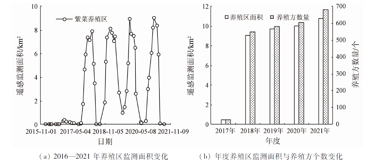
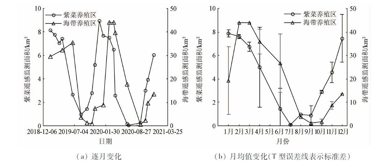
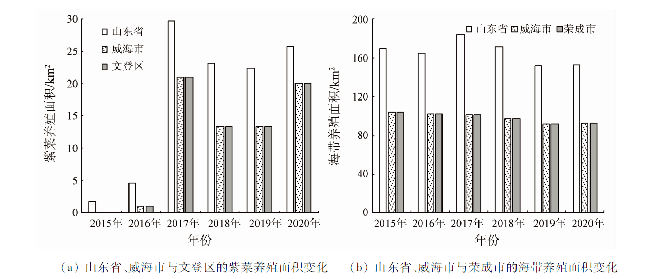
Monitoring the spatio-temporal dynamic changes in macroalgae aquaculture is crucial to its environmental management. However, few studies have been reported on the comparative monitoring of different macroalgae species. Based on images of the Sentinel-2 satellite and using the normalized difference vegetation index (NDVI) and the support vector machine (SVM), this study monitored the dynamic characteristics of both the Porphyra aquaculture area in the sea area of southern Wendeng District, Weihai City, Shandong Province and the kelp aquaculture area in the sea area of southern Rongcheng City, Weihai City. The results show that: ① The Porphyra aquaculture in Wendeng District was first captured in the satellite images of 2016, which is the same as the first year of Porphyra aquaculture in this city; the extraction method used in this study performed well in extracting the information about both the Porphyra and the kelp aquaculture areas overall, with the overall accuracy of 84% and above; ② During 2017—2021, the Porphyra aquaculture area monitored through remote sensing increased year by year and showed a trend far away from the shore; ③ The Porphyra and kelp aquaculture areas monitored both showed seasonal variations (high in winter and low in summer) of cold-water macroalgae aquaculture, but the minimum and maximum values of the Porphyra aquaculture area appeared 1~2 months earlier than those of the kelp aquaculture area. Compared with statistical yearbooks, satellite remote sensing can provide more accurate spatio-temporal information on macroalgae aquaculture. This study can be used as a reference in terms of monitoring technology and data for the management of macroalgae aquaculture in coastal areas of northern China.
Liu F L, Niu J F, Sui Z H, et al. Overview and prospects of China economic seaweed cultivation technology[J]. Journal of Agricultural Science and Technology, 2020, 22(12):1-9.
doi: 10.13304/j.nykjdb.2019.0795
Lu X, Gu Y, Wang X J, et al. The identification of Porphyra culture area by remote sensing and spatial distribution change and driving factors analysis[J] Marine Sciences, 2018, 42(7):87-96.
Li H, Qing P, Zhang X H, et al. Current status,problems and countermeasures of algae industry development in China[J]. Journal of Agricultural Science and Technology, 2021, 23(1):12-20.
Yue D D, Wang L M, Geng R, et al. Initial assessment of seaweed farming ecological value in coastal waters of China[J]. Journal of Agricultural Science and Technology, 2014, 16(3):126-133.
Wei Z N, Xing Q G, Guo R H, et al. Study on the spatial distribution variation of Porphyra aquaculture in the southern Yellow Sea during the period 2000—2015 retrieved by satellite remote sensing[J]. Journal of Ocean Technology, 2018, 37(4):17-22.
[6]
Xing Q, An D, Zheng X, et al. Monitoring seaweed aquaculture in the Yellow Sea with multiple sensors for managing the disaster of macroalgal blooms[J]. Remote Sensing of Environment, 2019, 231:111279.
doi: 10.1016/j.rse.2019.111279
Liu C C, Xu R, He P M, et al. Research on the relations between green tide and Porphyra cultivation in the south Yellow Sea[J]. Marine Sciences, 2017, 41(2):35-43.
Xu H P, Zhang Y Y, Zheng J. Research on the automatic extraction of floating raft aquaculture based on SR-NDVI and median filtering in Lianyungang[J]. Journal of Ocean Technology, 2021, 40(2):1-8.
Guo R H. Evaluation on the changes in the seaweed (Porphyra yezoensis) aquaculture in Jiangsu coastal waters using remote sensing[D]. Beijing: University of Chinese Academy of Sciences, 2017.
Chu J L, Shao G H, Zhao J H, et al. Information extraction of floating raft aquaculture based on GF-1[J]. Science of Surveying and Mapping, 2020, 45(1):92-98.
Wu Y T, Chen F, Ma Y, et al. Research on automatic extraction method for coastal aquaculture area using Landsat8 data[J]. Remote Sensing for Land and Resources, 2018, 30(3):96-105.doi:10.6046/gtzyyg.2018.03.14.
doi: 10.6046/gtzyyg.2018.03.14
[12]
Won E S, Ouchi K, Yang C S. Extraction of underwater laver cultivation nets by SAR polarimetric entropy[J]. IEEE Geoscience and Remote Sensing Letters, 2013, 10(2):231-235.
doi: 10.1109/LGRS.2012.2199077
Hu J C, Huang M D, Yu H Y, et al. Research on extraction method of offshore aquaculture area based on Sentinel-2 remote sensing imagery[J]. Marine Environmental Science, 2022, 41(4):619-627.
[14]
Lu X, Zhang Y Z, Zhang S, et al. Spatial change analysis of Porphyra yezoensis aquaculture in the Lianyungang coastal area by the use of remote sensing and geographic information system technology[J]. Journal of the Indian Society of Remote Sensing, 2019, 47(9):1609-1622.
doi: 10.1007/s12524-019-00987-7
[15]
曹万云. 荣成海带养殖时空变化与适宜性评价研究[D]. 烟台: 鲁东大学, 2016.
Cao W Y. Spatial-temporal variation and suitability evaluation of kelp culture in Rongcheng[D]. Yantai: Ludong University, 2016.
Ocean Net. Weihai seafood has added new products Wendeng thousand Mu seaweed harvested and listed[EB/OL].(2017-01-10)[2022-02-24]. http://www.hellosea.net/Product/7/2017-01-10/35877.html?cktove=ayvg03.
Wu J S, Pan K Y, Peng J, et al. Research on the accuracy of TM images land-use classification based on QUEST decision tree: A case study of Lijiang in Yunnan[J]. Geographical Research, 2012, 31(11):1973-1980.
doi: 10.11821/yj2012110005
 2023, Vol. 35
  ), 纪灵4, 邢前国1,2,3(