

0 引言
生态安全评价研究中构建指标框架和选定评价方法是关键内容。首先,生态安全评价模型有“压力—状态—响应”(press-state-response,PSR)模型[12]及扩展版“驱动力—压力—状态—影响—响应”(driving force-press-state-impact-response,DPSIR)模型[13]、“驱动力—压力—状态—响应”(driving force-press-state-response,DPSR)模型[14]、也有不同维度构成的自然—经济—社会(nature-economic-society,NES)模型[15]和经济—环境—社会(economic-environment-society,EES)模型[16]等。其中国际经济合作与发展组织提出的PSR模型是生态安全评价研究中应用最为普遍的框架模型。我国关于评价生态安全的方法包括景观模型法、生态模型法、数学模型法及数字地面模型法[17]。生态安全主要驱动因素分析研究是解决生态安全问题的重要步骤。生态安全驱动因素研究中发现生态安全在不同时空范围内的变化规律主要受2方面因素的影响,一方面是以自然因素为主的结构性因素[18]; 另一方面是以人类社会经济因素为主的非结构性因素,表征人类活动对生态环境的干扰性[19]。呙亚玲等[20]利用灰色关联度方法对洞庭湖区生态安全的主要影响因素进行了初步分析发现面临的主要问题为水资源短缺、人口密度和产业结构不合理。
内蒙古自治区鄂尔多斯市位于黄河流域中上游段,属于典型的农牧交错区、国家重要的能源储备基地和输出基地。近年来,经济飞速发展,同时由于资源过度利用、工业结构重型化且单一化严重等因素导致水土流失和荒漠化加剧,脆弱的自然环境与快速发展的社会经济之间的矛盾越来越突出[21]。本文综合分析鄂尔多斯市黄河流域旗县自然环境条件、社会经济发展现状选取19项生态安全指标,采用PSR模型生态安全模型对鄂尔多斯市黄河流域各旗县生态安全进行评价,测算出主要驱动因素并开发了生态安全预警系统,为黄河区域生态安全状态评价、检测和预警提供技术支撑,进而对黄河流域内蒙古段生态安全治理提供管理参考和技术应用示范。
1 研究区概况及数据源
1.1 研究区概况
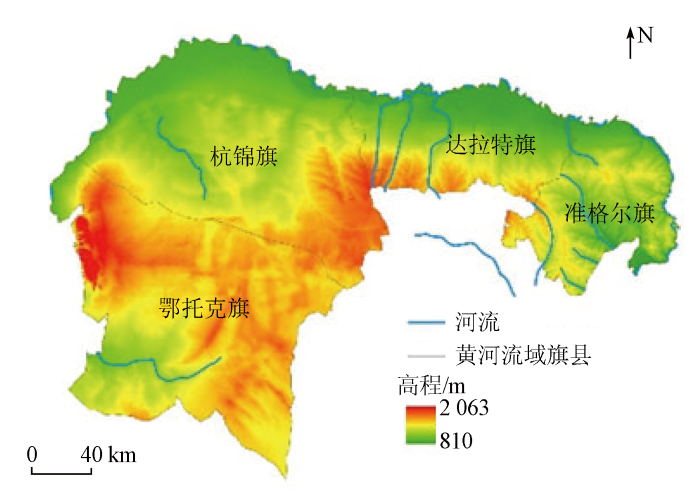
鄂尔多斯市位于内蒙古自治区西南部,地理位置为: E106°42'~111°27', N37°35'~40°51'。研究区范围如图1所示。
图1
1.2 数据源
本研究中使用的遥感数据是研究区2010—2020年空间分辨率为30 m×30 m的Landsat TM/OLI影像,进行几何纠正、彩色合成和镶嵌裁剪处理。结合遥感目视解译的结果与实地调查的数据,对影像分类结果进行精度评价,分类精度均高于70%。根据研究的目的,将研究区的土地利用划分为6类: 耕地、林地、草地、水体、裸地和建筑用地。社会经济统计数据来自鄂尔多斯市统计年鉴(2010—2020年),包括研究区范围内的综合数据、人口、国民经济、农牧业和工业等部分的统计数据[24]。
2 研究方法
2.1 鄂尔多斯市黄河流域旗县生态安全评价
结合鄂尔多斯市黄河流域旗县社会经济发展、产业结构、土地利用和生态保护政策等实际情况,在咨询相关专家的基础上,遵循科学性、可重复性、全面性、数据获得便利性等原则,最终确定了19个评价指标构建黄河流域旗县生态安全评价的指标体系[27⇓-29](表1)。压力指标表征研究区生态环境所承受的人为或自然的干扰程度,从社会发展、土地利用、资源消耗、环境承载程度等方面选出人口密度、城市面积、人均耕地面积、化肥施用强度、载畜量和沙地面积等6种指标; 状态指标表征研究区主要在人为或自然压力指标下呈现出的生态现状,筛选出草地覆盖率、森林覆盖率、农林牧渔业产值、人均粮食量、第三产业比重和水资源涵养量等指标解释研究区土地资源、经济产业结构、土地资源产量现状; 响应指标表征政府采取经济调整、生态治理等方法来减轻、预防人类活动对环境的干扰的响应措施,分别从经济响应及生态修复响应选出了农牧民人均纯收入、单位面积农业机械总动力、固定资产投资、人均国内生产总值(gross domestic product,GDP)、水利环境资金、人工造林面积和种草面积等项指标。
表1 生态安全指标的选择
Tab.1
| 目标层 | 准则层 | 指标层 | 指标 趋向 | 意义 |
|---|---|---|---|---|
| 生态 安全 综合 指数 | 压力 | 人口密度 | 负 | 表征人口对生态安全的压力 |
| 城市面积 | 负 | 表征城市化扩建对生态安全的压力 | ||
| 人均耕地面积 | 负 | 表征农业对生态安全的压力 | ||
| 化肥施用强度 | 负 | 表征农业对生态安全的压力 | ||
| 载畜量 | 负 | 表征畜牧业对生态安全的压力 | ||
| 沙地面积 | 负 | 表征植被退化对生态安全的压力 | ||
| 状态 | 草地覆盖率 | 正 | 表征草地资源覆盖状态 | |
| 森林覆盖率 | 正 | 表征森林资源覆盖状态 | ||
| 农林牧渔业产值 | 正 | 表征基础产业发展状态 | ||
| 人均粮食量 | 正 | 表征土地资源产量状态 | ||
| 第三产业比重 | 正 | 表征产业结构状态 | ||
| 水资源涵养量 | 正 | 表征水资源状态 | ||
| 响应 | 农牧民人均纯收入 | 正 | 表征国民经济发展的响应 | |
| 单位面积农业机械总动力 | 正 | 表征农业现代化的响应 | ||
| 固定资产投资 | 正 | 表征固定资产投入程度的响应 | ||
| 人均GDP | 正 | 表征区域经济发展的响应 | ||
| 水利环境资金 | 正 | 表征对水利环境保护投入程度的响应 | ||
| 人工造林面积 | 正 | 表征对森林资源保护的响应 | ||
| 种草面积 | 正 | 表征对草地资源保护的响应 |
首先,对生态安全指标进行标准化处理。正向、负向指标公式分别为:
式中: xij和yij分别为经过标准化处理前、后的第i年j种指标的值; maxj和minj分别为第j项指标的最大值和最小值。
其次,计算各指标权重。权重代表不同指标对生态安全指标建立的重要水平。为消除权重评价时的主观影响,本研究采用熵权法[17]对指标体系的权重进行计算。
计算表征第j种指标的第i种样本指标占比指数Fij,公式为:
计算第j种指标的熵值Wj,然后计算指标的信息效用价值dj,公式为:
再计算第j种指标权重ej,公式为:
设共有n个指标,有m个子系统,各个子系统包含的指标个数分别为n1,…,nk,…,nm个,n1+…+nk+…+nm=nr,设第j项指标属于第k个子系统。计算代表第i个样本第k个子系统(nk项指标)的综合测算值uik公式为:
最后,进行生态安全指数计算。采用生态安全综合指数法[28]来对黄河流域旗县生态安全进行分析,公式为:
式中: ESLm为压力、状态、响应3个层次的生态安全指数,为各子系统的生态安全指数(m=1,2,3); ESL为综合生态安全指数,ESI的取值范围为[0,1]; Wj为第j项指标的权重; Wp为第p项子系统的权重。
表2 生态安全警示等级划分
Tab.2
| 生态安全程度 | 生态安全指数 | 警度 等级 | 特征 |
|---|---|---|---|
| 不安全 | [0,0.2) | 重警 | 生态系统结构及功能被破坏,生态恢复能力及抗干扰能力较差,生态环境问题呈现恶化趋势 |
| 较不安全 | [0.2,0.4) | 高警 | 生态系统结构及功能不完整,生态问题较多,生态恢复能力及抗干扰能力降低 |
| 临界安全 | [0.4,0.6) | 中警 | 生态系统结构及功能基本完整,生态系统受外界干扰破坏较小,生态恢复能力及抗干扰能力一般 |
| 较安全 | [0.6,0.8) | 轻警 | 生态系统结构及功能较完整,生态问题较少,生态恢复能力降低,抗干扰能力较好 |
| 安全 | [0.8,1] | 无警 | 生态系统结构及功能较完整,生态环境未受干扰破坏,有很强的自我修复和调节能力 |
2.2 驱动因素分析
本研究结合鄂尔多斯市黄河流域旗县社会经济发展、产业结构和土地利用现状等实际情况,在咨询相关专家的基础上,遵循科学性、可重复性、全面性、数据获得便利性等原则分别从社会因素、自然因素、政策因素和经济因素等层次,提出了草地面积、年均气温、年降水、水资源面积、林地面积、载畜率、人口数量、城市面积、城镇化率、道路、恩格尔系数、GDP、第一产业比重、第二产业比重、第三产业比重、大型工业企业数量、生态补贴面积、人工种草面积和人工造林面积[3,31-32]等19种生态安全驱动因素。利用SPSS软件灰色关联度模型筛选出鄂尔多斯市黄河流域旗县生态安全的关键驱动因素。通过R语言方差分解模型分析鄂尔多斯市黄河流域旗县社会因素、自然因素、政策因素和经济因素层次生态安全驱动因素之间的耦合关系。
2.3 警情预测
表3 灰色预测精度检验等级
Tab.3
| 精度等级 | 指标临界值 | ||
|---|---|---|---|
| 相对误差 | 均方差比值 | 小误差概率 | |
| 一级 | 0.01 | 0.35 | 0.95 |
| 二级 | 0.05 | 0.50 | 0.80 |
| 三级 | 0.10 | 0.65 | 0.70 |
| 四级 | 0.20 | 0.80 | 0.60 |
3 结果与分析
3.1 生态安全评估
鄂尔多斯市黄河流域旗县生态安全评价指数熵权法分析权重结果(图2)显示,达拉特旗PSR模型指标中沙地面积、人均GDP、人均耕地面积和载畜量等指标的权重较大,均在6%~7%之间。准格尔旗种草面积、单位面积农业机械总动力、人均GDP和沙地面积等指标的权重较大。鄂托克旗PSR模型指标中载畜量、单位面积农业机械总动力、种草面积和草地覆盖率等指标的权重较大。杭锦旗PSR模型指标中载畜量、人均粮食量、沙地面积和人口密度等指标的权重较大。
图2
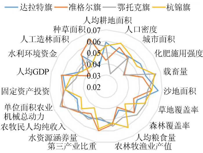
图2
黄河流域旗县生态安全评价指标框架及权重
Fig.2
Index framework and weight of ecological security evaluation in counties of the Yellow River basin
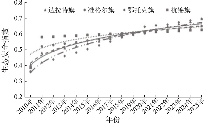
分析2010—2020年研究区生态安全评价PSR模型综合指数法分析结果(图3)可以看出安全指数均呈现增长趋势,生态系统健康状况稳定波动于临界安全状态,生态安全警示等级处于中警等级,说明鄂尔多斯市黄河流域旗县生态系统安全状况稳定且得到改善。
图3
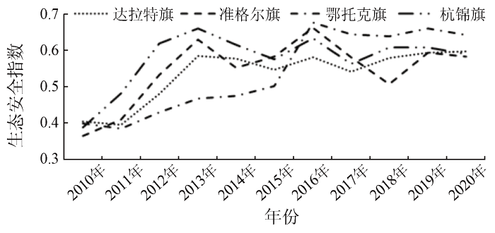
图3
鄂尔多斯市黄河流域各旗县生态安全变化
Fig.3
Changes of ecological security in counties of the Yellow River basin in Ordos City
2010—2013年达拉特旗生态安全指数迅速增长,2013—2020年变化不大,压力指标逐渐降低,响应指标逐渐增长,2016年开始响应指标大于压力指标。准格尔旗2010—2020年生态安全指数逐渐增长,安全级别波动于临界安全状态。响应指标大于压力指标,表示该地区做出的响应措施高于环境压力。鄂托克旗2010—2013年生态安全指数一直增长,2017年后回落并波动于临界安全等级。压力与响应指标也逐渐增加,响应指标大于压力指标。杭锦旗2010—2013年生态安全指数呈现增长趋势,2013年之后生态安全指数呈现下降趋势,压力指标逐渐下降,2017年小于响应指标。4个旗县压力、状态、响应的具体变化情况如图4所示。
图4
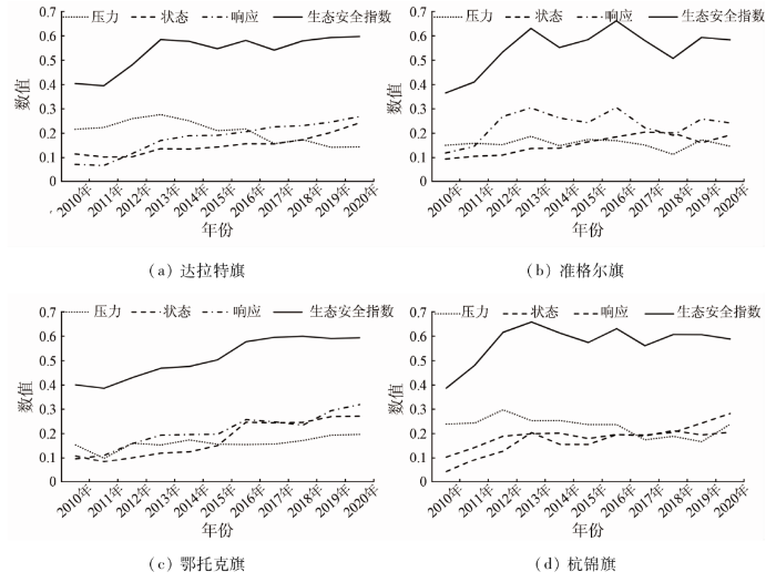
图4
4个旗县2010—2020年生态安全变化趋势
Fig.4
Trends of ecological security in four counties from 2010 to 2020
达拉特旗耕地面积的增加等因素给区域生态环境带来了压力。沙地比重在一定程度上代表区域植被退化程度。达拉特旗进行造林总场生态工程的投入有效减少沙地面积,对其生态安全状况改善效应最为明显。准格尔旗经济的发展导致人均GDP提升、农业现代化技术提升、对环境保护的投入力度增加,间接对生态环境改善起到了驱动作用。鄂托克旗对退耕还林、退牧还草生态工程及农业现代化技术的投入改善了区域生态安全现状,同时畜牧业承载压力对环境的改善具有抑制作用。杭锦旗对库布齐沙漠的生态治理得到了一定的成效,沙地面积得到了有效控制。与此同时城市扩建和人口压力等社会因素对生态环境带来了人为压力,对杭锦旗生态安全起到抑制作用。
总体来说,鄂尔多斯市黄河流域旗县为退耕还林、退牧还草、三北防护林等重点生态工程的投入对黄河流域旗县生态状况改善起到关键作用。鄂尔多斯市森林覆盖率从2010年的12.26%到2020年增长到27.3%,对该地区的水土流失以及生态保护起到了积极作用。虽然鄂尔多斯市生态文明建设取得了一定成效,但鄂尔多斯市“十年九旱”、2个“48%”的市情没有得到根本上的解决,自然环境条件依旧脆弱的状况没有发生变化。从产业结构发展来看,鄂尔多斯市黄河流域耕地为2 267 km2,占全市的55%,全市绝大部分农业人口和农业生产活动集中在黄河流域,加上重工业发展结构的单一性、城镇化进程中人口压力和城市扩建等对原本就脆弱的自然生态环境造成较大压力,使得生态安全状态未达到理想状态。
3.2 生态安全驱动因素分析
鄂尔多斯市黄河流域旗县驱动因素灰色关联度分析结果(图5)显示达拉特旗生态安全动态变化与区域经济指标恩格尔系数、第三产业比重,社会指标城镇化率、城市面积及政策指标大型工业企业数量关联度最高。准格尔旗生态安全动态变化与区域社会指标城镇化率、人口数量、城市面积,自然指标年均气温和水资源面积关联度最高。鄂托克旗生态安全动态变化与区域自然指标林地面积、水资源面积,社会指标城市面积及经济指标GDP和第三产业比重关联度最高。杭锦旗生态安全动态变化与区域自然指标草地面积、水资源面积,社会指标人口数量、城镇化率及经济指标第三产业比重关联度最高。
图5
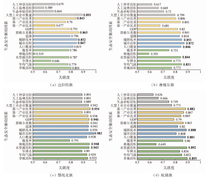
图5
4个旗县生态安全驱动因素分析
Fig.5
Analysis of driving factors of ecological security in four counties
鄂尔多斯市黄河流域旗县生态安全驱动因素研究中,人口数量、城镇化率和城市面积等社会指标极大地制约着整个地区生态系统的安全。随着经济发展,城市面积增多,城市化进程大大加快,人口大量增加,城镇化率的增加给该地区的生态环境带来巨大的人为干扰压力。自然影响因素中,草地资源覆盖率、水资源和载畜量影响着生态系统结构的完整性及功能稳定性,很大程度上影响着鄂尔多斯市黄河流域地区生态系统的安全。水资源是干旱地区农业发展的主要约束条件,煤炭资源开发的重要因素,对工业、农牧业的高质量发展提供优良条件[22]。经济层面上黄河流域旗县恩格尔系数和GDP等经济指标与生态系统的安全呈现正相关关系,对生态环境改善具有积极作用。第三产业比重增大,经济发展进程不断加快,煤炭工矿企业迅速发展,在该地区的产业结构中,重工业的收益远远大于畜牧业和林业,使得区域社会经济快速发展的同时生态环境面临更大的压力,水土流失和土地损毁等问题更加严重,区域自然、社会和地理条件愈加复杂,因此政府机关投入了大量的修复工程,生态奖补政策及人工造林等生态措施对于生态安全状态恶化具有缓冲作用。
鄂尔多斯市黄河流域旗县生态安全驱动因素耦合关系结果(图6)显示政策因素的单独贡献率最高,为0.18。说明鄂尔多斯市近年来为退耕还林、退牧还草、三北防护林等重点生态工程的实施对研究区域生态状况改善起到积极作用。经济因素与政策因素的耦合贡献最高,为0.25。其次为社会因素与自然因素的耦合贡献率,为0.13。
图6
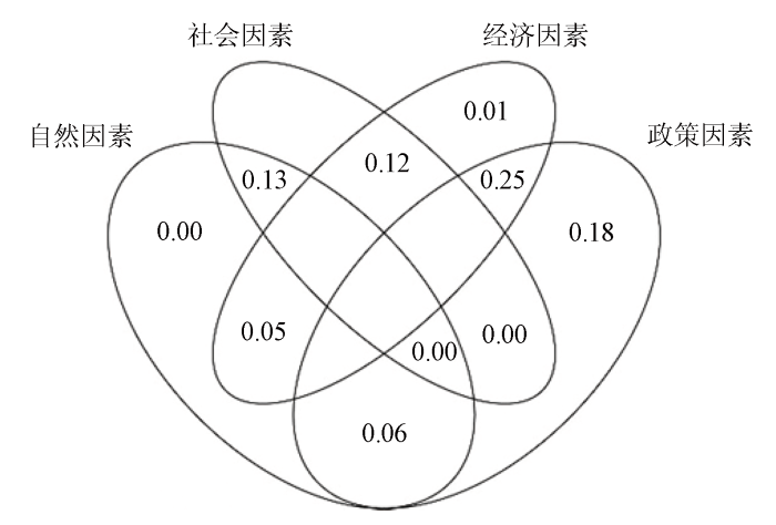
图6
鄂尔多斯市黄河流域旗县安全驱动因素耦合关系
Fig.6
Coupling relationship of driving factors of ecological security in Ordos City
3.3 生态安全变化预测
利用灰色系统预测方法对2010—2020年鄂尔多斯市黄河流域各旗县生态安全综合指数结果进行GM(1,1)模型的构建,实现鄂尔多斯市黄河流域旗县其后未来5 a生态安全情况的预测。鄂尔多斯市黄河流域旗县其后未来5 a的生态安全预测结果(图7)显示达拉特旗、准格尔旗、鄂托克旗和杭锦旗生态安全呈上升趋势。总体来看,黄河流域旗县生态安全指数呈现上升并稳定发展,警度状态波动于中警生态安全等级,表明鄂尔多斯市黄河流域旗县生态安全管理措施仍需加强。
图7
参照灰色预测模型精度检验表,达拉特旗、准格尔旗、鄂托克旗和杭锦旗检验结果(表4)相对误差、均方差比及小误差概率检验精度分布于一级、二级、三级。由此可见,模型精度较高,可以作为鄂尔多斯市黄河流域旗县生态安全的预测模型。
表4 灰色预测精度检验
Tab.4
| 检验指标 | 相对误差 | 均方差比 | 小误差概率 |
|---|---|---|---|
| 达拉特旗 | 0.05 | 0.34 | 0.90 |
| 准格尔旗 | 0.09 | 0.38 | 0.80 |
| 鄂托克旗 | 0.05 | 0.41 | 0.90 |
| 杭锦旗 | 0.08 | 0.50 | 0.80 |
4 讨论
1)注重生态建设与经济建设的协调发展,以生态环境修复工作作为重点任务,投入大量的生态环保资金,进行封山育林、退耕还林、退牧还草等项目,取得了可观的成绩[36]。
2)改善生产结构,第三产业占比增高,减轻了区域生产过程中产生的环境污染及生态压力问题[23]。
3)施展了小流域治理工程项目,结合生物措施与工程措施办法,对流域水土保持进行综合高效的治理。
4)全面改善煤炭产业高质量发展模式,提升煤炭开采技术,倡导清洁、高效、安全、智能化产业结构,促进了煤炭等自然资源的绿色、高效、集约节约利用[37]。
鄂尔多斯市黄河流域旗县生态安全状态得到改善,但生态安全并未达到理想状态。因此,鄂尔多斯市需要大力发展经济的同时进一步增强生态保护和环境修复投资,着重减少生态污染排放,提升资源利用效率,消减经济发展所产生的黄河流域生态环境压力,科学建立生态安全风险防范体系。结合本研究结果提出以下政策建议:
1)林草资源对维护生态平衡、减轻生态环境负担发挥着关键作用。加快实施退耕还林还草方案,增加生态奖补力度,促进建设以森林、草地为主体的区域生态安全屏障,加强防护林带的建设。
2)城市建设与发展要注重生态环境保护,优化并升级产业结构,把控产业和资源开发超过生态环境阈值,矿采资源开发,在严格遵循“开发与保护并重”的原则和土地用途管制制度的前提下,改良工期、区域及方式。
3)黄河沿岸主要为灌溉农业区,优化农业结构,提高水利化程度,促进农牧业现代化发展。
4)大力宣传黄河文化教育意义,提高民众黄河流域生态保护意识,健全相应的法律法规,增加生态环境保护科技资金投入,提升高等院校、科技部门对黄河流域生态安全研究的重视程度。
本研究不足之处,由于统计年鉴数据获取的可得性,统计数据是以旗为单元导致最后的结果有明显的旗边界。如果能够获得镇、乡和苏木的数据,将会大大提高评价结果的空间精度,为当地的生态环境管理提供更为有效的技术支持。
5 结论
本研究以鄂尔多斯市黄河流域生态安全为出发点,在遥感技术和社会统计年鉴数据的支持下,获取了达拉特旗、准格尔旗、鄂托克旗、杭锦旗2010—2020年11 a间的生态安全指标数据,运用熵权法确定其指标权重并基于“压力—状态—响应”模型构建了适合鄂尔多斯市黄河流域生态环境的生态安全评价指标框架; 再使用灰色关联度模型分析黄河流域旗县关键的生态安全驱动因素,最终建立鄂尔多斯市黄河流域生态安全预警系统。得出以下结论:
1)2010—2020年鄂尔多斯市黄河流域旗县达拉特旗、准格尔旗和鄂托克旗生态安全综合评价指数均呈现上升趋势,杭锦旗生态安全指数呈先上升后下降趋势,生态安全等级均波动于临界安全状态,说明该区域流域生态系统安全有所改善。
2)研究区生态安全动态变化与区域人口数量、城镇化率、草地面积、水资源面积、恩格尔系数和第三产业比重变化有紧密联系。
3)各旗县生态安全预测模型结果显示其后未来5 a该地区生态安全指数均呈现增长趋势,说明鄂尔多斯市黄河流域旗县生态安全逐渐改善且稳定发展。
参考文献
黄河流域生态保护与高质量发展的协调推进策略
[J].
Coordinated promotion strategy of ecological protection and high-quality development in the Yellow River basin
[J].
沿黄城市群生态保护与高质量发展协同度研究
[J].
Research on the coordination degree of ecological protection and high-quality development of urban agglomerations along the Yellow River
[J].
长江经济带土地生态安全时空演化特征及影响因素
[J].
Spatio-temporal evolution characteristics and influencing factors of land ecological security in the Yangtze River economic belt
[J].
基于PSR模型的三峡库区生态经济区土地生态安全评价
[J].
Regional land ecological security evaluation in the case of Chongqing Three Gorges Reservoir ecological economy area based on the PSR model
[J].
基于PSR方法的山东省耕地生态安全评价
[J].
Ecological security assessment of cultivated land in Shandong Province base on PSR model
[J].
基于PSR模型的云贵高原湿地生态系统健康评价
[J].
Ecosystem health assessment of the Yunnan-Guizhou plateau wetland based on the pressure-state-response model
[J].
基于PSR模型的东阳江流域生态安全评价
[J].
Ecological security assessment of the Dongyang River watershed using PSR modeling
[J].
基于DPSR模型的陕西关中城市群生态安全预警评价研究
[J].
On early warning and evaluation of ecological security in Guanzhong urban agglomeration based on DPSR model
[J].
基于PSR模型的西北五省森林生态安全评价
[J].
Forest ecological security evaluation of five northwest provinces based on PSR model
[J].
Urban ecological security evaluation and spatial correlation research:Based on data analysis of 16 cities in Hubei Province of China
[J].DOI:10.1016/j.jclepro.2021.127613 URL [本文引用: 1]
三峡库区土地整理生态安全评价——以黔江区水田乡为例
[J].
The study on ecological security environment of regional land consolidation of the Three Gorges:A case study in Shuitian Town in Qianjiang City
[J].
我国耕地生态安全评价及障碍因子诊断
[J].
Evaluation on cultivated land ecological security based on the PSR model and diagnosis of its obstacle indicators in China
[J].
基于DPSIR模型的流域生态安全评价指标体系研究
[J].
A DPSIR-based indicator system for ecological security assessment at the basin scale
[J].
基于DPSR模型的城市新区生态安全评价研究——以西咸新区沣西新城为例
[J].
Research on ecological security assessment of urban new district based on DPSR model: A case study of Fengxi new town in Xixian new area
[J].
基于EES-PSR的土地生态安全物元模型评价方法实证研究
[J].
Empirical study on evaluation method of land ecological security Matter-element model based on EES-PSR
[J].
基于DPSIR-EES-TOPSIS模型的重庆市土地生态安全评价及其时空分异
[J].
Spatiotemporal variation and land ecological security and its evaluation in Chongqing City based on DPSIR-EES-TOPSIS model
[J].
基于PSR模型及熵权法的土地生态安全评价研究——以兰州市为例
[J].
Land ecological security assessment based on PSR model and entropy weight method: A case study of Lanzhou City
[J].
基于改进PSR模型的洞庭湖区生态安全评价及主要影响因素分析
[J].
Ecological security evaluation and main effects analysis around Dongting Lake based on the improved pressure-state-response model
[J].
黄河流域产业发展对生态环境的胁迫诊断与优化路径识别
[J].
DOI:10.18402/resci.2020.01.13
[本文引用: 1]

黄河流域是中国区域发展战略格局的重要支撑区以及国土生态安全的关键区域,也是国家重要的能源安全支撑区和粮食安全基地。但受区位条件、自然地理环境和资源禀赋等因素影响,该地区经济基础相对薄弱,以能源重化工为主的单一化产业体系加重了地区生态环境负担。本文在辨析黄河流域生态保护与高质量发展主要限制因素的基础上,分析了地区产业发展对生态环境本底、大气环境、水资源与水环境、生态功能的胁迫特征,总结了地区产业发展与生态环境保护的主要矛盾及需要把握的关系;提出实现黄河流域生态保护与高质量发展目标,必须处理好产业开发布局与流域生态环境安全格局稳定、重点区域产业发展与资源环境承载能力、重点突破与系统统筹的关系。为此,建议该地区应优化产业发展路径,积极推进以绿色循环为核心的新型工业化,提升产业发展层次;以地区资源环境约束促进能源基础原材料产业规模控制和效率提升;以资源环境承载力为基础优化产业空间布局,确定适宜的产业发展空间和生态保护红线,推进重点能源化工基地建设和城市群产业集聚区建设;加强能矿资源开发的生态空间管控与生态修复,实施一批区域性生态环境治理和修复工程。
Environmental stress and optimized path of industrial development in the Yellow River basin
[J].
DOI:10.18402/resci.2020.01.13
[本文引用: 1]
The Yellow River Basin is a key area for China’s regional development strategy and national ecological security. However, affected by the location, physical environment, and resource endowments, the economic foundation of the region is relatively weak. It has formed an industrial system dominated by energy and heavy chemical industries, which greatly increased the regional ecological burden. The Yellow River Basin is facing the predicaments of weak economic foundation and weak development ability, the pressures of accelerating social and economic development and transformation of development mode, the contradictions between resource use and ecological protection and between industrial development and environmental carrying capacity, and the challenges of deteriorating local living environment. The core contents of ecological environment protection and high-quality development of the Yellow River Basin is to balance the relationship between resource use and environmental protection, the scale of development and the carrying capacity of resources and the environment, and the development of key areas and the protection of the total ecological security to ensure energy security, ecological security, food security, watershed security, and the health of human settlements. We suggest that the region should optimize the industrial development path, actively promote the new industrialization with green industrial development as its core, and improve the level of industrial development and resource and environmental efficiency; optimize the industrial space based on the resource and environmental carrying capacity, determine suitable industrial development space and ecological protection red line, promote the construction of key energy and chemical bases and the construction of industrial clusters in urban agglomerations, implement strict environmental access policies, and improve environmental control standards for industrial development; strengthen spatial control and ecological restoration of energy and mining development projects, and implement a series of regional ecological environment governance and restoration projects.
鄂尔多斯市土地利用生态安全格局构建
[J].
Building ecological security pattern based on land use: A case study of Ordos,northern China
[J].DOI:10.5846/stxb URL [本文引用: 3]
鄂尔多斯市黄河流域生态保护和高质量发展初步研究
[J].
Preliminary study on ecological protection and high-quality development of the Yellow River basin in Ordos City
[J].
Analysis of ecological security evaluation and zoning threshold determination of typical energy industrial area based on PSR model
[J].
DOI:10.1088/2515-7620/ac9514
[本文引用: 1]
Ecological security is the main way to measure the effects of urbanization and industrialization in developing regions on the ecological environment. As an important coal chemical industry base in China, Taiyuan is located in the Loess Plateau, resulting in great pressure on the ecological environment. Based on the pressure-state-response (PSR) model, this study selected 15 evaluation indicators to evaluate the ecological security of 10 counties(districts/city) in Taiyuan City. Using the spatial principal component analysis (SPCA) method and GIS technology to simulate and analyze the ecological security distribution of this area, for the first time, the typical method and average method were used to divide the threshold of the ecological security level to achieve a more reasonable ecological security classification method. The results showed that from 2000 to 2016, the ecological security level of Taiyuan city and its surrounding areas was relatively low, mainly concentrated in Xinghualing, Yingze and Jiancaoping districts, while the ecological security level of Loufan county, Qingxu County, Gujiao city and Yangqu County was relatively high. Among these, energy mining and urbanization have had a relatively obvious impact on ecological security. It could provide more detailed ideas for the protection of ecological security in different areas and enrich the research on the ecological security of important coal chemical bases.
Study about ecological security assessment of Beijing valley region based on PSR model: A case study of Puwa Valley region in Fangshan District
[J].
DOI:10.1088/1755-1315/281/1/012011
[本文引用: 1]
The analytic hierarchy process (AHP) was used to evaluate the ecological security of Beijing valley region. Based on the concept model of PSR (Pressure-State-Response), and referred to the current assessment methods of the ecological security evaluation, relating AHP to construct evaluation system, this study combined the impact factors of natural, social and economic on Valley Region ecological security, the mutual influence and restraint law of the internal system between various factors, AHP was used to establish the ecological security assessment indicators system of Beijing Valley Region. Compared with 2010 increased 0.08, The score of ecological security about Puwa Valley Region was 0.63 which attained general status. At last, this study promoted corresponding advices.
基于PSR模型的耕地生态安全物元分析评价
[J].
Evaluation on cultivated land ecological security based on the PSR model and matter element analysis
[J].DOI:10.5846/stxb URL [本文引用: 1]
基于压力-状态-响应模型的黑河中游张掖市生态安全评价
[J].
Ecological security evaluation of Zhangye City in the middle reaches of the Heihe River based in pressure-state-response model
[J].
Water ecological security assessment and spatial autocorrelation analysis of prefectural regions involved in the Yellow River basin
[J].
DOI:10.1038/s41598-022-07656-9
PMID:35332130
[本文引用: 1]
To have a more comprehensive understanding of the water ecological security status of the Yellow River Basin, this paper constructs a water ecological security evaluation index system founded on the Pressure-State-Response (PSR) model. The indicators are selected by considering factors such as meteorological conditions, population, economy, water resources, water environment, water ecology, land ecology, ecological service functions, pollution control, and capital investment. Then, the "single index quantification-multiple indices syntheses-poly-criteria integration (SMI-P) method was used to determine the water ecological security index (WESI) of 62 cities in the Yellow River Basin, to classify the safety levels, and combined with the spatial autocorrelation analysis to study the regional characteristics. The results prove that: (a) The overall water ecological security of the Yellow River Basin is relatively poor. Half of the 62 cities have reached the second-level warning level, and most of them are concentrated in the upper and middle reaches of the basin. (b) Wetland area is a long-term key factor in the construction of water ecological safety, and the greening rate of built-up areas has an increasing impact on water ecological safety. (c) The overall water ecological security index shows a slow upward trend, with the annual average growth rate was 0.59%. (d) The water ecological security of 62 cities in the Yellow River Basin shows significant spatial autocorrelation. The findings can offer a practical basis for the water ecological management to promote the high-quality development of the Yellow River Basin.© 2022. The Author(s).
基于多源数据的三江源国家公园土地生态安全综合评价
[J].
Comprehensive evaluation of land ecological security in the Sanjiangyuan National Park based on multi-source data
[J].
生态安全评价方法及其应用
[J].
Review on methodology and application of ecological security assessment
[J].
黄河流域旅游生态安全的动态演变特征及驱动因素
[J].
DOI:10.11821/dlxb202203015
[本文引用: 1]
科学测度与审视旅游生态安全对促进黄河流域旅游经济和生态环境协调可持续发展具有重要的理论和实践价值。从流域可持续发展视角,基于DPSIR系统模型构建黄河流域旅游生态安全理论框架和指标体系,采用改进TOPSIS法、核密度曲线、空间自相关、传统和空间马尔可夫链及面板分位数回归方法对其动态演化特征和驱动因素进行探析。结果表明:① 时间上,旅游生态安全均值波动下降后上升,呈收敛趋势,且有向“双核”形态演变的趋势。空间上,旅游生态安全值整体较低(0~0.55),由2008年以风险级为主(占89.04%)转变为2017年以风险级和恶化级为主(分别占60.27%和31.51%),且仍存在较大下行转移风险。② 动态演化特征上,不考虑邻域条件下,旅游生态安全风险级、敏感级转移具有“路径依赖”与“自身锁定”效应。而恶化级、临界安全级保持初始状态概率较小,且类型转移通常发生在相邻等级递次转移。邻域背景在其动态变化过程中起着重要作用,且其动态演化特征具有显著时空异质性。③ 影响因素方面,环境污染对低层级单元的旅游生态安全负向抑制作用较为明显,旅游负荷水平对较高层级地区旅游生态安全的正向边际效应略大,而旅游发展水平、经济发展水平等变量则对较低等级单元旅游生态安全的正向边际效应较大。
Dynamic evolution characteristics and driving factors of tourism ecological security in the Yellow River basin
[J].
DOI:10.11821/dlxb202203015
[本文引用: 1]
It is of great theoretical and practical importance to measure and examine tourism ecological security in the Yellow River Basin (YRB). The purpose of this study is to promote coordinated and sustainable development of the tourism economy and ecological environment. From the perspective of watershed sustainable development, this paper constructs the theoretical framework and index system of tourism ecological security in the YRB based on DPSIR system model, and analyzes its dynamic evolution characteristics and driving factors by using improved TOPSIS method, kernel density estimation, spatial autocorrelation, traditional and spatial Markov chains and quantile regression panel method. The results showed that: (1) There has been an evolutionary trend toward a dual-core form of tourism ecological security over time, as its average value fluctuates and then rises. The overall tourism ecological security level was relatively low (0-0.55), shifting from the predominant risk level in 2008 (accounting for 89.04%) to the levels of predominant risk and deterioration in 2017 (60.27% and 31.51%, respectively). A large downward risk remains. (2) In terms of dynamic evolution characteristics, the transfer of tourism ecological security risks and sensitive levels had "path dependence" and "self-locking" effects. In practice, however, the probability of maintaining the initial state of the deterioration level and the critical safety level was relatively small. And the type of transfer was usually accomplished during a subsequent level transfer. Its dynamic change process was strongly influenced by regional factors. Its characteristics of dynamic evolution were characterized by significant spatial and temporal heterogeneity. (3) Tourism ecological safety was most significantly influenced by environmental pollution in lower-level units. The tourism load level had a greater positive marginal effect on higher-level areas; however, economic development and level of tourism development have a greater positive marginal effect on areas with lower ecological tourism security levels.
煤炭资源富集区生态安全预警技术方法与应用研究
[J].
Research on ecological security warning technology and its applications in rich coal resource areas
[J].
基于PSR框架模型的三峡库区忠县汝溪河流域生态系统健康评价
[J].
Assessment of ecosystem health in the Ruxi River basin of Zhongxian County in the Three Gorges reservoir area based on pressure-state-response(PSR)model
[J].
基于“压力-状态-响应”模型的土地生态安全评价及预测——以沈阳市为例
[J].
Evaluation and prediction of land ecological security based on PSR model: Take Shenyang as an example
[J].
内蒙古鄂尔多斯市城镇化进程中土地生态安全动态评价研究
[J].
Dynamic evaluation of land ecological security in the process of urbanization in Ordos City,Inner Mongolia
[J].
