

0 引言
鉴于我国尾矿库数量多、分布广等特点,传统的人工实地勘察方式费时费力且受地面条件限制大,无法满足尾矿库监测的高时效性要求。遥感技术具备覆盖范围广、数据获取周期短等优势,已成为当前尾矿库监测、识别的重要技术手段。目前基于遥感的尾矿库监测技术方法可以分为3类: ①人机交互的目视解译方法。如郝利娜等[4]基于WorldView-2影像从光谱、结构和纹理3类特征出发建立了鄂东南地区尾矿库的目视解译标志,并将尾矿库与道路和矿山建筑的空间伴生关系作为不同规模尾矿库的特有识别因子; 于博文等[5]根据铁矿尾矿库在GF-1影像中的特有特征建立解译标志,完成了京津地区的铁矿尾矿库的调查监测; 高永志等[6]对山谷型、截河型等不同类型尾矿库分别建立解译标志完成了黑龙江省重点矿区的尾矿库目视解译,并根据监测结果对当地尾矿库的潜在危险进行了定性分析。②基于面向对象的分类方法。如曹兰杰等[7]通过构建铁尾矿库的光谱特征强化指数,基于GF-1影像建立了面向对象的铁尾矿库提取流程; 范莹琳等[8]基于北京二号高分影像对迁西地区铁尾矿库的光谱、纹理和形状特征开展综合分析,提出基于多特征的面向对象尾矿库提取方法。③基于SSD,U-Net和YOLO等深度学习模型的提取方法。如张成业等[9]以U-Net为基础框架设计了针对尾矿库目标识别的网络结构; Lyu等[10]结合YOLO v4模型与随机森林算法成功对尾矿库的边缘进行识别; 闫凯等[11]、李庆等[12]和Li等[13]利用改进后的SSD目标检测模型分别对我国华北地区和京津冀地区的尾矿库开展了自动识别研究。此外,也有部分研究直接根据尾矿库的光谱和纹理等特征建立的指数模型进行尾矿库识别[14-15]。
上述研究为基于遥感的尾矿库识别监测提供了重要参考,但目前针对尾矿库监测的技术策略仍存在不足。首先,虽然目视解译提取精度高,但自动化程度低,需要大量人机交互工作; 其次,尾矿库的空间分布范围广且存在不确定性,基于面向对象的方法容易受到其他与尾矿库特征近似地物的干扰; 最后,深度学习模型训练的好坏普遍对样本数量和样本质量的依赖性高,而不同类型、不同等级及不同生产阶段的尾矿库在遥感影像上的特征均可能存在差异,人工误差及目标本身的易混淆性会导致样本的纯净性不足,从而严重影响模型的训练效果。
尾矿库自动监测的难点在于尾矿库所处的自然场景类型多样、相似地物干扰多、特征复杂多变,因此仅利用遥感影像单一数据源较难获得理想的尾矿库提取结果。互联网和物联网等信息技术的快速发展推动了大数据时代的到来,除影像数据外,各类统计数据、调查与考察数据、众源地理空间数据和基础地理信息数据等多源地理数据等逐渐成为城市功能区识别、国土资源调查监测等研究的重要数据来源[16-17]。Liu等[18]综合影像、道路网矢量和兴趣点(point of interest,POI)等数据开展了城市内部的土地利用分类研究; 赵云涵等[19]利用建筑物轮廓和POI等数据并结合随机森林算法提取了广州天河区的城中村,提取结果正确率达到89%。上述研究证实了耦合多源地理数据进行地物类型识别的可行性,但鲜有学者将此技术策略用于尾矿库的遥感识别监测研究中。
尾矿库虽然空间分布范围广,但其在地理区位上通常与周边的矿区、选矿厂、冶炼厂和重要交通道路等距离较近,借助相关企业空间分布点位、道路网等数据可辅助实现尾矿库潜在分布区域的快速定位,进而提高尾矿库的监测效率和识别精度。综上所述,在前人研究基础上,本研究以云南省个旧市为例,面向大尺度区域的尾矿库监测监管需求,融合多源地理数据和高分辨率卫星影像进行尾矿库遥感调查监测工作,以期为尾矿库的监督管理提供技术支撑和决策依据。
1 研究区概况
研究区为云南省红河哈尼族彝族自治州个旧市,地理范围在E102°51'~103°26',N23°08'~23°39'之间。海拔在140~2 800 m之间,全市总面积约1 559 km2,具体地理位置如图1所示。
图1
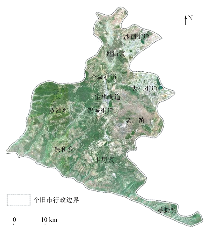
个旧市地处云贵高原南部,矿藏资源类型多样且极为丰富,是一个以锡为主,铜、铅、锌等多种有色金属及稀有金属伴生的超大型矿区,已探明锡储量超过200万t,有色金属储量超过800万t,被誉为“中国锡都”[20]。个旧市在长期的矿产开采过程中建造了大量的尾矿库,对尾矿库进行高频次、精确化和自动化的遥感监测,对个旧市矿区安全生产管理、矿区生态环境保护及矿业经济可持续发展等具有重要意义。
2 研究方法
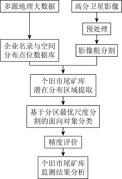
本研究主要技术路线如图2所示。首先,通过对尾矿库相关行业类型进行分析,基于多源数据建立包含企业经营地址、行业类别和经纬度等关键信息在内的重点关注企业名录与空间分布点位数据库; 然后,对预处理后的高分影像进行粗尺度分割,结合企业空间分布点位数据提取尾矿库的潜在分布区域; 最后,在已有粗分割的基础上,执行基于分区最优尺度分割的面向对象分类以完成尾矿库空间范围的识别,并根据提取结果对个旧市尾矿库的分布特征及存在问题进行分析。
图2
2.1 重点关注企业名录与空间分布点位数据库建立
个旧市内所分布的尾矿库主要是有色金属矿采选业及有色金属冶炼和压延加工业的相关企业在矿产资源开采与冶炼过程中建立的,通过收集政府相关部门公开数据资料、互联网信息和工商企业信息平台数据等多源数据,对此类重点关注企业名录及关键属性信息(包括生产经营场所地址、行业类别、生产经营状态和经营范围等)进行提取; 并结合企业注册地行政区划、地址信息和网络地图POI信息,利用公共地理编码服务获取其经纬度坐标; 最后根据预先设定的业务规则开展数据清洗、筛选与整合工作,建立个旧市有色金属矿采选业及有色金属冶炼和压延加工业的企业名录与空间分布点位数据库。
基于该数据库可实现个旧地区重点关注企业空间位置的快速定位,从而辅助后续基于高空间分辨率遥感影像的尾矿库潜在区域提取,并为尾矿库空间范围的进一步精确识别提供位置指引。
2.2 遥感影像预处理
GF-6卫星于2018年6月2日发射,该卫星搭载了2 m全色/8 m多光谱的高分辨率相机(pan and multi-spectral,PMS)和16 m的宽幅多光谱相机(wide field of view,WFV),影像幅宽可达90 km,具备高空间分辨率和宽覆盖范围的双重优点。本文所用影像数据为2019年2月6日GF-6卫星PMS传感器获取的高空间分辨率影像,传感器参数介绍如表1所示。
表1 GF-6卫星PMS传感器参数
Tab.1
| 传感器 | 波段 | 波长范围/μm | 空间分辨率/m | 幅宽/km |
|---|---|---|---|---|
| GF-6 PMS | 全色 | 0.45 ~ 0.90 | 2 | 90 |
| 蓝光 | 0.45 ~ 0.52 | 8 | 90 | |
| 绿光 | 0.52 ~ 0.59 | 8 | 90 | |
| 红光 | 0.63 ~ 0.69 | 8 | 90 | |
| 近红外 | 0.77 ~ 0.89 | 8 | 90 |
GF-6影像预处理基于ENVI 5.5软件平台完成,主要包括辐射定标、大气校正、几何纠正和影像融合等。其中,正射校正采用有理多项式系数(rational polynomial coefficients,RPC)模型,采用影像自带的RPC参数完成模型参数优化解算; 大气校正采用基于 MODTRAN5 辐射传输模型的FLAASH模块完成; 最后,采用Gram-Schmidt算法将全色波段和多光谱波段融合生成空间分辨率2 m的多光谱融合影像,该算法能够较好保持影像的纹理和光谱信息,信息失真程度小。
2.3 尾矿库潜在分布区域提取
受交通运输、运营成本、地形起伏等限制和影响,尾矿库在地理位置上往往分布于企业矿区、选矿厂和冶炼厂等周边区域,且距离主要交通道路较近。借助重点关注企业空间分布点位数据、数字高程模型(digital elevation model,DEM)和道路网矢量等多源地理数据,可实现尾矿库潜在分布区域的快速定位和提取。
采用基于面向对象的方法对可能存在尾矿库的区域进行提取。首先,对高分辨率影像进行粗尺度分割,影像分割使用eCognition Developer 8.7软件中的多分辨率分割算法完成,将预处理后的遥感影像图层与DEM图层叠置,各波段权重均设定为1,形状因子与紧致度因子依据经验分别设定为0.4和0.5,并使用道路网矢量数据对分割过程进行控制。同时,借助ESP多尺度分割工具以确定最优分割尺度,最终确定分割尺度参数为1 000。影像粗分割完成后,将数据库中企业的空间分布点位数据与分割对象进行空间叠置分析,仅保留区域内分布有本研究所关注重点企业点位的对象,并将其作为尾矿库的潜在分布区域。
2.4 尾矿库空间范围识别
尾矿库潜在分布区域确定后,采用一种基于分区最优尺度分割的面向对象分类方法进行尾矿库空间范围的精确识别。首先,基于影像粗分割结果虽能确定尾矿库大致的空间分布区域,但粗分割所使用的分割尺度参数过大,不能准确分割尾矿库与其周边的背景地物,因此必须对尾矿库潜在分布区域执行进一步的精细化分割。应当指出,这里的进一步分割并不是直接对整个尾矿库潜在分布区域的影像重新进行分割,而是在粗分割基础上,对每个粗分割对象所对应区域的影像分别使用ESP工具确定最优分割尺度参数,然后分区执行影像分割。鉴于不同规模的尾矿库占地面积差异较大,分区确定最优分割尺度参数的策略可保证不同区域内最终分割对象的大小和边界均能够准确表征各尾矿库的真实轮廓,有效避免对尾矿库的过分割和欠分割。
结合个旧市尾矿库的影像特征及现场实地调研情况发现,尾矿库与周边地物在光谱和纹理特征方面均存在显著差异,金属矿砂的尾砂是各类矿石破碎物混合而成,在影像上多表现为浅灰色或浅白色,而尾矿库中的水体由于大量尾砂的存在其色调相对于自然水体更亮; 此外,尾矿库内部植被稀疏,外围植被则相对茂盛; 尾砂在排放过程中会随着水体流速的减慢而逐渐沉淀,在影像上呈现出明显的放射状或扇形纹理特征。综合以上分析,选择各波段亮度均值和标准差、归一化植被指数、归一化水体指数及经主成分分析提取的第一主成分分量计算的灰度共生矩阵以构建分类特征空间。在分区精细分割完成后,计算上述特征空间中的各分类特征并进行训练样本的选择,最后采用随机森林机器学习分类器完成对尾矿库空间范围的识别与提取。
2.5 精度评价
本文采用精确率P、召回率R和F1值3个指标对尾矿库最终提取结果进行精度评价。其中,精确率指正确识别的尾矿库像元数量占被识别为尾矿库像元总数量的百分比,即用户精度; 召回率指正确识别的尾矿库像元数量占地面真实尾矿库像元总数量的百分比,即制图精度; F1 是精确率和召回率的调和平均数,是精度综合评价指标。上述3个指标的计算公式分别为:
式中: TP为正确识别的尾矿库的像元数量; FN为将尾矿库错误识别为非尾矿库的像元数量; FP为将非尾矿库错误识别为尾矿库的像元数量; TN为正确识别的非尾矿库的像元数量。
3 结果与分析
3.1 尾矿库识别与精度评价结果
尾矿库潜在分布区域的提取结果如图3所示。从所需处理影像面积变化的角度看,原始影像覆盖区域面积为1 559.0 km2,提取尾矿库潜在分布区域面积为418.7 km2,待处理影像面积降低了73.1%,数据处理量大幅缩减。此外,对不存在尾矿库的区域进行排除,显著减少了与尾矿库特征相似且易混淆的地物数量,有利于后续尾矿库空间范围精确识别的速度与精度的提升。
图3
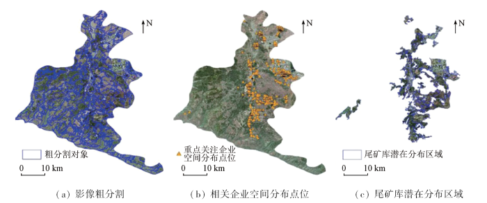
图3
尾矿库潜在分布区域提取结果
Fig.3
Extraction results of potential distribution area of tailings ponds
采用基于高分影像的人工目视解译结合实地调查验证(图4)的方式获取验证样本,完成对提取结果的精度验证。结果显示,尾矿库提取结果的精确率和召回率分别为83.9%和72.4%,F1值为77.7%,基本满足个旧市尾矿库空间范围快速识别与监测的需求,证实了本文融合多源地理数据与高分辨率遥感影像的技术策略在大尺度区域开展尾矿库识别与监测的有效性。个旧市尾矿库提取结果如图5所示,共识别出尾矿库46座,总面积为970.2 hm2; 其中绝大部分为面积小于10 hm2的小型尾矿库,共23座,主要分布在大屯街道、锡城街道、老厂镇和卡房镇; 面积在[10,20)hm2和[20,50] hm2的尾矿库分别为7座和11座,主要分布在锡城街道和老厂镇; 面积超过50 hm2的大型尾矿库有5座,其中规模最大的是官家山尾矿库,面积达到142.3 hm2(图5)。
图4
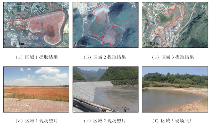
图4
个旧市部分典型尾矿库提取结果及实地现场调查照片
Fig.4
Extraction results and field survey photos of some typical tailings ponds in Gejiu City
图5
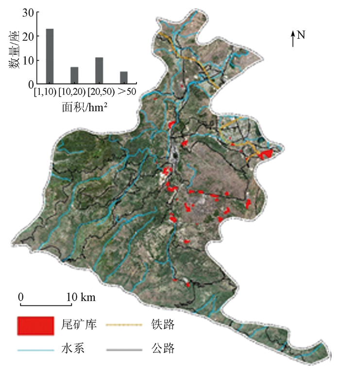
图5
个旧市尾矿库提取结果及面积统计结果
Fig.5
Extraction results and area statistics of tailings ponds in Gejiu City
3.2 个旧市尾矿库监测结果分析
通过对个旧市尾矿库的监测结果及现场实地调研情况分析,个旧市尾矿库的空间分布格局具有以下特征: ①尾矿库数量众多,空间分布范围广。个旧市尾矿库总数量达到46座,分布范围涉及宝华街道、金湖街道、大屯街道、锡城街道、鸡街镇、老厂镇和卡房镇7个行政区,有尾矿库的行政区占个旧市总面积的一半以上。②尾矿库空间分布散乱,局部区域密度过高。总体而言,尾矿库主要分布在个旧市中部和东南部地区的乡镇和街道内,西部地区几乎没有尾矿库分布,其中锡城街道和老厂镇存在大量尾矿库密集分布区域(平均分布密度约0.11个/km2),尾矿库分布密度过高,聚集程度较为严重; 以占地面积较小的小型尾矿库居多,此类小型尾矿库一般多为私营选矿场的企业建造,其开矿和选矿等可能具有较大随意性且缺乏科学规划引导,这在一定程度上加剧了尾矿库空间分布的散乱性; 从所处地形地貌特征看,尾矿库主要分布在海拔高且坡度较大的山区附近,类型以傍山型和山谷型尾矿库居多,伴有部分平地型尾矿库,部分山谷区域内尾矿库呈高度集聚状态。③尾矿库在空间位置上普遍邻近河流、交通道路和居民地等环境敏感受体。存储在尾矿库中的废渣和废液等含有大量重金属和有毒药剂成分,受土壤风化、地表径流等作用,这些物质极易渗入并扩散到周边的河流和土壤中,造成土壤酸化、盐渍化和地下水污染等环境破坏,进而导致农作物减产和有害元素超标等问题[21-22]。具体而言,个旧市距上述几类环境敏感受体直线距离小于1 km的尾矿库有29座,占到全部尾矿库总数量的63%,这些尾矿库对周边地区环境敏感受体造成危害的可能性最大,在矿山环境整治过程中,要特别重视和加强对上述尾矿库的安全监测和生态环境治理工作。
4 结论与展望
针对大尺度区域内尾矿库高频次、高精度和自动化监测的实际需求,提出了融合多源地理数据和高分辨率遥感影像的尾矿库识别策略和技术方案,并以云南省个旧市为研究区进行了应用验证。主要结论如下:
1)融合多源地理数据与高分影像进行尾矿库潜在分布区域的初步提取可有效排除不存在尾矿库的干扰区域,减少与尾矿库特征相似且易混淆的地物数量,大幅降低影像数据处理量,提高后续尾矿库空间范围识别的速度和精度。
2)在确定尾矿库潜在分布区域的基础上,基于分区最优尺度分割的面向对象分类方法取得了较好的分类效果,尾矿库提取结果的精确率和召回率分别为83.9%和72.4%,F1值为77.7%,能够满足个旧市尾矿库空间范围快速识别与监测的需求。
3)个旧市尾矿库监测结果显示,个旧市尾矿库数量众多,共有46座,尾矿库空间分布散乱且局部区域密度过高并表现为高度聚集状态,63%的尾矿库在空间位置上邻近河流、道路和居民地等环境敏感受体,需重点加强对此类尾矿库的安全监测和生态环境治理工作。
当前技术方案的实验仅在县级区域尺度开展,后续工作中将继续探索和推广在市级、省级乃至全国尺度范围的尾矿库快速识别监测中的实际应用。此外,为进一步提高对尾矿库的监测能力及环境保护力度,未来还需加强对尾矿库内部要素(坝体、排洪设施、尾砂和废水等)识别的深入研究。
参考文献
尾矿库安全评价存在的问题与对策
[J].
Problems and countermeasures of safety evaluation of tailing pond
[J].
Global-scale impact analysis of mine tailings dam failures:1915—2020
[J].DOI:10.1016/j.gloenvcha.2021.102361 URL [本文引用: 1]
尾矿库环境风险管控相关政策分析及建议
[J].
Analysis and suggestions of environmental risk control strategy for tailings ponds
[J].
鄂东南尾矿库高分辨率遥感图像识别因子研究
[J].
Tailings reservoir recognition factors of the highresolution remote sensing image in southeastern Hubei
[J].
高分一号卫星在京津矿山遥感监测中的应用
[J].
Application of GF-1 satellite in remote sensing monitoring on mine exploitation in Beijing and Tianjin
[J].
黑龙江省矿集区尾矿库遥感监测与分析
[J].
Remote sensing monitoring and analysis of tailings ponds in the ore concentration area of Heilongjiang Pro-vince
[J].
面向对象的高分一号铁尾矿遥感信息提取与分析
[J].
Object-oriented information extraction and analysis of the iron tailings with GF-1 remote sensing image
[J].
基于面向对象的铁尾矿信息提取技术研究——以迁西地区北京二号遥感影像为例
[J].
Information extraction technologies of iron mine tailings based on object-oriented classification:A case study of Beijing-2 remote sensing images of the Qianxi Area,Hebei Province
[J].
基于U-Net网络和GF-6影像的尾矿库空间范围识别
[J].
Recognition of the spatial scopes of tailing ponds based on U-Net and GF-6 images
[J].
Extracting the tailings ponds from high spatial resolution remote sensing images by integrating a deep learning-based model
[J].
DOI:10.3390/rs13040743
URL
[本文引用: 1]

Due to a lack of data and practical models, few studies have extracted tailings pond margins in large areas. In addition, there is no public dataset of tailings ponds available for relevant research. This study proposed a new deep learning-based framework for extracting tailings pond margins from high spatial resolution (HSR) remote sensing images by combining You Only Look Once (YOLO) v4 and the random forest algorithm. At the same time, we created an open source tailings pond dataset based on HSR remote sensing images. Taking Tongling city as the study area, the proposed model can detect tailings pond locations with high accuracy and efficiency from a large HSR remote sensing image (precision = 99.6%, recall = 89.9%, mean average precision = 89.7%). An optimal random forest model and morphological processing were utilized to further extract accurate tailings pond margins from the target areas. The final map of the entire study area was obtained with high accuracy. Compared with the random forest algorithm, the total extraction time was reduced by nearly 99%. This study can be beneficial to mine monitoring and ecological environmental governance.
基于深度学习的SSD模型尾矿库自动提取
[J].
DOI:10.7523/j.issn.2095-6134.2020.03.009
[本文引用: 1]
针对华北地区尾矿库自动提取问题,将基于深度学习的SSD目标检测模型应用于遥感图像尾矿库提取。首先标记华北地区2 000个样本,随机挑选1 500个作为训练样本,剩余样本作为测试样本,验证模型的检测精度。分析卷积层对应感受野与图像中尾矿库尺寸关系,发现原始SSD模型漏检误检大型尾矿库。改进SSD模型结构,提出增加额外卷积层的策略,提高对大型尾矿库目标的检测精度。实验表明,在置信度阈值为0.3时,改进的SSD模型相比原始模型,检测精确率提高10.0%,召回率提高14.4%,提高了大型尾矿库检测精度。验证了基于深度学习的SSD目标检测模型自动提取尾矿库的可行性以及改进算法的有效性。
Automatic extraction of tailing pond based on SSD of deep learning
[J].
DOI:10.7523/j.issn.2095-6134.2020.03.009
[本文引用: 1]
In order to automatically extract tailing ponds in North China, the SSD target detection model based on deep learning is applied to extract tailing ponds from remote sensing images. Firstly, 2 000 samples in North China were labeled as the foundation of database. 1 500 samples were randomly selected as training samples, and the remaining samples were used as test samples to verify the detection accuracy of the model. By using the original SSD model, the targets of large tailing ponds can not be detected accurately. In this work the relationship between the corresponding receptive field of convolution layer and the size of tailing reservoir in image was analyzed. Moreover, in order to improve the detection accuracy of the model for large-scale tailing pond targets, we modified the structure of SSD model by introducing an extra convolution layer. Experiments show that, compared with the original SSD model, the modified SSD model improves the detection accuracy by 10% and the recall rate by 14.4% at 0.3 confidence level. The detection accuracy for large tailing ponds is also improved. In this work, the feasibility of automatic extraction of tailing reservoir based on deep learning SSD model and the effectiveness of the modified algorithm were verified.
基于SSD模型的京津冀地区尾矿库检测
[J].
Detection of tailings pond in Beijing-Tianjin-Hebei region based on SSD model
[J].
Detection of tailings dams using high-resolution satellite imagery and a single shot multibox detector in the Jing-Jin-Ji region,China
[J].
DOI:10.3390/rs12162626
URL
[本文引用: 1]
The timely and accurate mapping and monitoring of mine tailings dams is crucial to the improvement of management practices by decision makers and to the prevention of disasters caused by failures of these dams. Due to the complex topography, varying geomorphological characteristics, and the diversity of ore types and mining activities, as well as the range of scales and production processes involved, as they appear in remote sensing imagery, tailings dams vary in terms of their scale, color, shape, and surrounding background. The application of high-resolution satellite imagery for automatic detection of tailings dams at large spatial scales has been barely reported. In this study, a target detection method based on deep learning was developed for identifying the locations of tailings ponds and obtaining their geographical distribution from high-resolution satellite imagery automatically. Training samples were produced based on the characteristics of tailings ponds in satellite images. According to the sample characteristics, the Single Shot Multibox Detector (SSD) model was fine-tuned during model training. The results showed that a detection accuracy of 90.2% and a recall rate of 88.7% could be obtained. Based on the optimized SSD model, 2221 tailing ponds were extracted from Gaofen-1 high resolution imagery in the Jing–Jin–Ji region in northern China. In this region, the majority of tailings ponds are located at high altitudes in remote mountainous areas. At the city level, the tailings ponds were found to be located mainly in Chengde, Tangshan, and Zhangjiakou. The results prove that the deep learning method is very effective at detecting complex land-cover features from remote sensing images.
Remote sensing extraction method of tailings ponds in ultra-low-grade iron mining area based on spectral characteristics and texture entropy
[J].DOI:10.3390/e20050345 URL [本文引用: 1]
Mine tailing extraction indexes and model using remote-sensing images in southeast Hubei Province
[J].DOI:10.1007/s12665-019-8439-1 [本文引用: 1]
地理国情大数据研究框架
[J].
Research framework of geographical conditions and big data
[J].
Big data-enabled social sensing in spatial analysis:Potentials and pitfalls
[J].DOI:10.1111/tgis.v22.6 URL [本文引用: 1]
Classifying urban land use by integrating remote sensing and social media data
[J].DOI:10.1080/13658816.2017.1324976 URL [本文引用: 1]
耦合多源大数据提取城中村建筑物——以广州市天河区为例
[J].
Integrating multi-source big data to extract buildings of urban villages:A case study of Tianhe District,Guangzhou
[J].
个旧市矿产资源开发环境代价核算
[J].
A preliminary discussion of environment cost caused by mineral resource exploitation in Gejiu City
[J].
Risk evolution study of tailings dam failures disaster based on DEMATEL-MISM
[J].
DOI:10.3389/feart.2022.906486
URL
[本文引用: 1]
Tailings pond engineering is a complex and extensive system with many risk factors that can trigger a dam failure. It is important to clarify the evolutionary relationships among the factors and to enhance effective management to reduce the risk of dam failure. In this paper, an effective and reliable method for analyzing the evolution of tailings pond dam failure risk by combining DEMATEL and MISM is proposed. Firstly, 35 risk factors affecting tailings pond failure were summarized. An index system for evaluating the imfluence factors of dam failure was constructed from four aspects: personnel, management, environment, and system. Secondly, the Decision-making Trial and Evaluation Laboratory (DEMATEL) was used to study the influence relationships among the factors, for analyzing and identifying the key causal factors. Subsequently, the Modified Interpretative Structural Model Method (MISM) was used to classify the cause factors into five levels of influence as well as to determine the degree of integrated influence between the risk factors. Finally, an evolutionary model of tailings pond dam failure risk was constructed based on the results of the analysis. The results of the study indicated the followings: 1) System risk accounted for 58.58% of the total weight, while personnel risk accounts for 15.51%. To maintain the stability of the tailings pond system, personnel risk should not be neglected in addition to focusing on systemic factors. 2) Rainfall intensity was an essential causal factor. Focusing on rainfall intensity and taking appropriate measures effectively reduced the risk of dam failure. The height of the dam and the depth of the seepage line accounted for a large proportion of the causal factors, making it possible to control the height of the dam and accurately monitor the depth of the seepage line to improve the stability of the dam. 3) In the tailings pond dam risk evolution model, there were 30 factors with higher mutability and correlation, which played a transitional role in risk transfer. A risk factor transfer network diagram was established for this purpose as a diagnostic map. The research results can provide new methods and ideas for tailings dam failure risk analysis research and practice.
Current knowledge of seepage from oil sands tailings ponds and its environmental influence in northeastern Alberta
[J].
DOI:10.1016/j.scitotenv.2019.05.407
[本文引用: 1]
Seepage of oil sand process-affected waters (OSPW) from tailings ponds into surface waters is a common concern in the minable oil sands region of northeast Alberta. Research on seepage has been extensive, but few comprehensive treatments evaluating all aspects relevant to the phenomenon are available. In this work, the current information relevant for understanding the state of seepage from tailings ponds was reviewed. The information suggests the infiltration of OSPW into groundwater occurs near some ponds. OSPW may also be present in sediments beneath the Athabasca River adjacent to one pond, but there are no clear observations of OSPW in the river water. Similarly, most water samples from tributaries also show no evidence of OSPW, but these observations are limited by the lack of systematic, systemic, and repeated surveys, missing baseline data, standard analytical approaches, and reference materials. Waters naturally influenced by bitumen, discharge of saline groundwaters, and dilution also potentially affect the consolidation of information and certainty of any conclusions. Despite these challenges, some data suggest OSPW may be present in two tributaries of the Athabasca River adjacent to tailings ponds: McLean Creek and Lower Beaver River. Irrespective of the possible source(s), constituents of OSPW often affect organisms exposed in laboratories, but research in all but one study suggests the concentrations of organics in the surface water bodies assessed are below the standard toxicological effect thresholds for these compounds. In contrast, many samples of groundwater, irrespective of source, likely affect biota. Biomonitoring of surface waters suggests generic responses to stressors, but the influence of natural phenomena and occasionally nutrient enrichment are often suggested by data. In summary, valuable research has been done on seepage. The data suggest infiltration into groundwater is common, seepage into surface waters is not, and anthropogenic biological impacts are not likely. (C) 2019 Elsevier B.V.
