

0 引言
早在20世纪80年代,国际上以欧美为主就开始生态网络理论与实践的探索[4]。国内关于生态网络的研究较晚但发展迅速,学界对生态网络构建开展广泛探索[5],已形成“确定生态源地,构建阻力基面,提取生态廊道”的基本范式[6]。构建方法多样,有形态学空间格局分析法(morphological spatial pattern analysis,MSPA)[7],电路理论法[8],图论法[9]、生态系统服务和权衡的综合评估模型(integrated valution of ecosystem services and trade-offs,InVEST)[10]、最小累积阻力模型(minimum cumulative resistance,MCR)[3]等。MSPA方法能够从景观结构、类型等角度出发识别生态价值高且连通性好的生态斑块; MCR能考虑多方面因素,构建综合阻力面提取潜在生态廊道[11]。因此,基于MSPA-MCR模型的生态网络相关研究较为广泛[12]。如王雪然等[13]采用该方法构建了太湖流域生态网络安全模式; 王玉莹等[14]对苏南地区森林生态网络做了探索; 陈南南等[7]探究了秦岭山地的生态网络结构。此外,学界也比较关注生态网络的层级嵌套特征研究,如朱捷等[15]通过“属性-功能-结构”三位一体的源地综合指标体系构建层级嵌套生态网络; 王戈等[16]运用复杂网络的评价指标对属干旱区的包头市进行层级生态网络构建; 姚晓洁等[17]在县域尺度上对生态源地进行分级分析。综上,生态网络研究以对湿润区森林生态系统的网络研究为主,对干旱半干旱区的研究偏少; 以对生态网络基本连通结构构建为主,对层级生态网络研究偏少。
宁夏回族自治区中卫市是黄河上游的重要节点区域,位于腾格里沙漠东南边缘,是典型的干旱半干旱地区,水土流失、植被破坏严重,生态系统脆弱,重要生态用地出现严重的破碎化,区域生态风险增加。本文基于MSPA-MCR模型,对能量因子模型和重力模型进行改进,提出MSPAP-MCRF模型,尝试构建中卫市层级嵌套生态网络,以期为同类区生态网络安全格局的构建与优化提供一定的决策参考。
1 研究区概况与数据来源
1.1 研究区概况
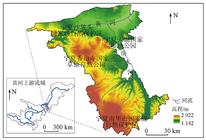
宁夏中卫市地处黄土高原丘陵沟壑区、黄河冲积平原及沙漠戈壁地理单元的过渡区,E104°17'~ 106°10',N36°06'~37°50',总面积13 649.37 km2。地势西南高,东北低,属干旱气候类型区,受沙漠影响,日照充足,昼夜温差大,平均气温在7.3~9.5 ℃之间,年均降水量为180~367 mm,现有南华山国家级自然保护区、沙坡头国家级自然保护区、天湖国家湿地公园和香山寺国家草原自然公园(图1)。境内水系主要为黄河及一级支流清水河。黄河干流从黑山峡入境,境内长度约182 km,清水河自东南向西北,在中宁县泉眼山西侧注入黄河。植被以干草原和荒漠草原为主,随着人类活动强度的增大,出现草原退化、沙漠化等问题,生态环境脆弱,生态风险较大。
图1
1.2 数据来源与预处理
采用的数据源有遥感影像、数字高程模型(digital elevation model,DEM)、路网、水系等。其中,遥感影像及DEM数据均源于地理空间数据云(
2 研究方法
2.1 MSPAP生态源地识别及等级划分方法
2.1.1 基于MSPA的生态源地初选
表1 MSPA景观类型及含义
Tab.1
| 景观类型 | 含义 | 阈值 |
|---|---|---|
| 核心区 | 生境斑块较大,可为物种提供较大栖息地,作为生态源地 | 17/117 |
| 孔隙 | 核心区和非绿色景观斑块之间的过渡区域,即内部斑块边缘,具有边缘效应 | 5/105 |
| 孤岛 | 连接度较低,内部物质、能量交流和传递可能性较小,不相连的孤立、破碎小斑块 | 9/109 |
| 边缘区 | 核心区和主要非绿色景观区域之间的过渡区域 | 3/103 |
| 环岛 | 连接统一核心区的廊道,规模小、与外围自然斑块的连接度低 | 65/165 |
| 桥接区 | 连接核心区的狭长区域,对生物迁移和景观连接具有重要意义 | 33/133 |
| 支线 | 只有一端与其他景观类型相连的区域 | 1/101 |
2.1.2 基于景观连通性的生态源地筛选
景观连通性具有促进或阻碍物种间交流及景观元素间物质和能量的交换的作用[20]。本文通过可能连通性指数(probability of connectivity,PC)、斑块重要性指数(important value of patches,dPC)和整体连通性指数(integral index of connectivity,IIC)计算,从核心区中筛选景观连通性较好的斑块用于后续研究。公式分别为:
式中:
2.1.3 基于生态红线的生态源地确定方法
生态红线是指生态空间范围内具有特殊生态功能、必须强制性严格保护的区域,是区域内重要的生态保护核心区,是国家和区域生态安全重要的保障,也是构建生态安全格局的关键,通常包括生态功能重要区域以及生态环境敏感脆弱区域。兼顾区域社会经济发展与生态保护的需求,本文将生态红线数据与MSPA分析得到的核心区进行叠置分析,以二者的重合区作为最终生态源地。
2.1.4 能量因子模型及生态源地等级划分标准
1)修正的能量因子模型。生态源地有不同的生态能量,重要性也具有明显差异。本文增加了生态源地修正系数对能量因子模型P[16]进行修正,公式为:
式中: Pj为第j块生态源地的能量因子; Mj为第j块源地修正系数(按照生态源地斑块的林地和水体占比之和的大小进行排序,参考相关文献[21],对前20%的生态源地赋值为5,前21%~40%的源地赋值为3,其余的源地则赋值为1); Aj为第j生态源地的面积; Njk为第j生态源地的均值; k分别取值1和2,Nj1为第j生态源地的EVI均值,Nj2为第j生态源地的MNDWI均值。其中,EVI和MNDWI值均由同期的Landsat8 OLI_TIRS影像计算获取,公式为:
式中: ρNIR,ρRED,ρBLUE,ρGREEN和ρMIR分别为近红外波段、红光波段、蓝光波段、绿光波段和中红外波段的反射率。
2)能量因子标准化方法。为消除量纲的影响,采用线性比例标椎化法中的极大值法对能量因子值进行标椎化处理,将能量因子标准化处理到0~1之间,公式如下:
式中:
3)生态源地等级划分方法。生态源地的能量因子不同,在生态网络中的影响力不同。本文拟采用等间距法对这种差异进行分级处理,其中,值在(0.70,1.0]之间的划分为一级源地,值在(0.30,0.70]之间的划分为二级源地,剩余的能量因子偏低的源地即划分为三级源地。
2.2 潜在生态廊道计算模型MCRF
式中: Gij为生态源地斑块i,j间的相互作用力; 分别为生态源地i,j的能量因子;
表2 阻力值体系评价表
Tab.2
| 阻力因子 | 分级指标 | 阻力值 | 权重 |
|---|---|---|---|
| 高程/m | <1 300 | 10 | 0.07 |
| [1 300,1 500) | 50 | ||
| [1 500,1 700) | 70 | ||
| [1 700,1 900) | 100 | ||
| [1 900,2 100) | 120 | ||
| ≥2 100 | 150 | ||
| 坡度/(°) | <8 | 10 | 0.13 |
| [15,25) | 20 | ||
| [15,25) | 30 | ||
| [25,35) | 50 | ||
| ≥35 | 100 | ||
| 土地利用 类型 | 林地 | 10 | 0.36 |
| 水域 | 20 | ||
| 草地 | 30 | ||
| 耕地 | 70 | ||
| 未利用地 | 100 | ||
| 建设用地 | 120 | ||
| 植被覆盖度/% | <30 | 120 | 0.24 |
| [30,40) | 80 | ||
| [40,50) | 50 | ||
| [50,60) | 30 | ||
| ≥60 | 10 | ||
| 道路/m | <20 | 220 | 0.20 |
| [20,50) | 180 | ||
| [50,80) | 140 | ||
| [80,110) | 100 | ||
| ≥110 | 60 |
2.3 生态网络结构评价
为将复杂网络结构进行定量评价,采用网络闭合度(α指数)、线点率(β指数)和连接度指数(γ指数)作为评价指标[25]。公式分别为:
式中: L为网络中廊道的数目; V为网络中抽象出来的生态节点个数。α取值为[0,1],网络不存在回路时,α=0; 网络中已经达到最大回路数目时,α=1。网络的复杂性会随着β的值而发生变化,β=0时,网络不存在; β>1时,网络复杂程度高。网络中只存在孤立的点时,γ=0; 反之,节点之间完全相互连接,γ=1。
3 结果与分析
3.1 中卫市生态源地基本特征分析
3.1.1 生态源地空间分布特征
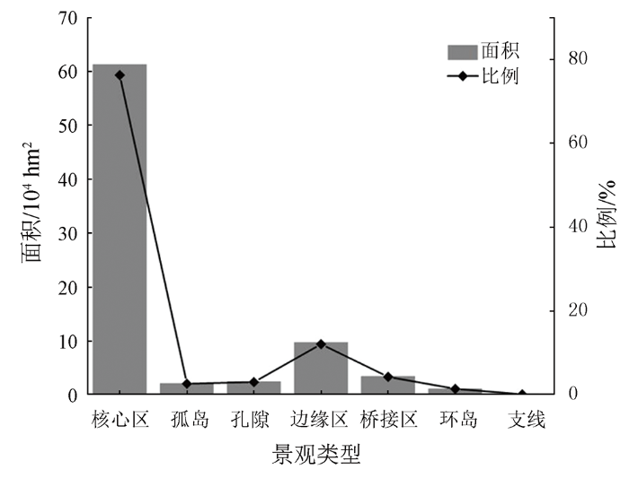
中卫市降水量少而蒸发量大,草地属于基质植被,是多种草原动物的重要栖息地。MSPA 的7种景观类型总面积为80.39×10⁴hm2,占研究区的58.9%,其中,核心区面积为61.24×10⁴hm2,占前景数据的76.18%,且主要以草地为主,占86.81%,其次是林地,占11.46%,水体占比最低,占1.52%; 边缘区和桥接区面积较大,分别为9.74×1
图2
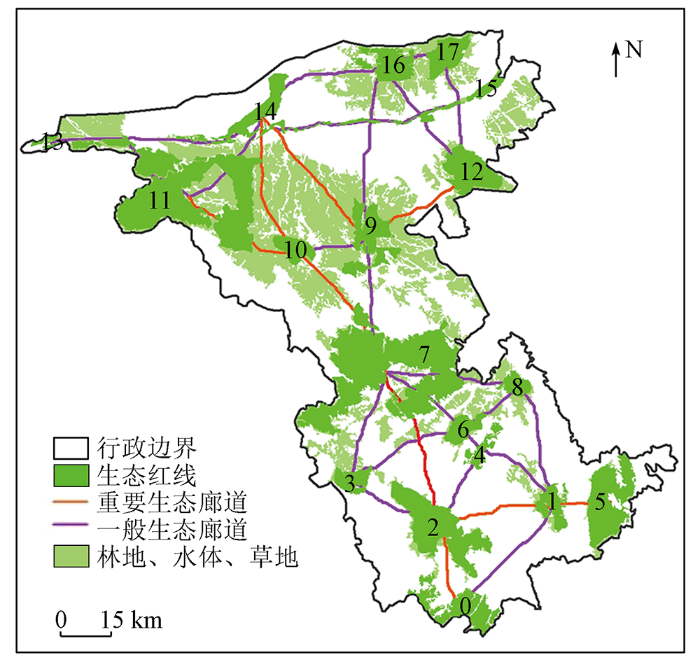
通过MSPA分析计算(图3(a)),得到的核心区斑块共有23 376块。由于Conefor2.6软件承载数据的能力较小,学者多选择面积较大的前30个源地斑块进行景观连通性计算[7],具有主观性。本文则对核心区碎片化数据修正合并,筛选出面积贡献率大于15%的源地斑块,即面积大于1 000 hm2的区域,作为景观连通性分析的基础数据。参考前人研究结果[24,26],经过多次模拟,将距离阈值设置为2 000 m,连接概率设置为0.5,对获取的生态源地进行评价,提取dPC>0.05对应的源地与生态红线数据进行叠置分析(图3(b)),以二者的重合区共17块作为最终生态源地,总面积为30.48×10⁴ hm2,占研究区22.33%。总体来看,中卫市生态源地分布均匀,生态源地包括了国家级及省级自然保护区等重要生态功能区。
图3
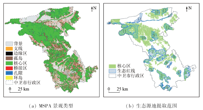
图3
MSPA景观要素空间分布及生态源地提取结果图
Fig.3
Spatial distribution of MSPA landscape elements and extraction results of ecological sources
图4
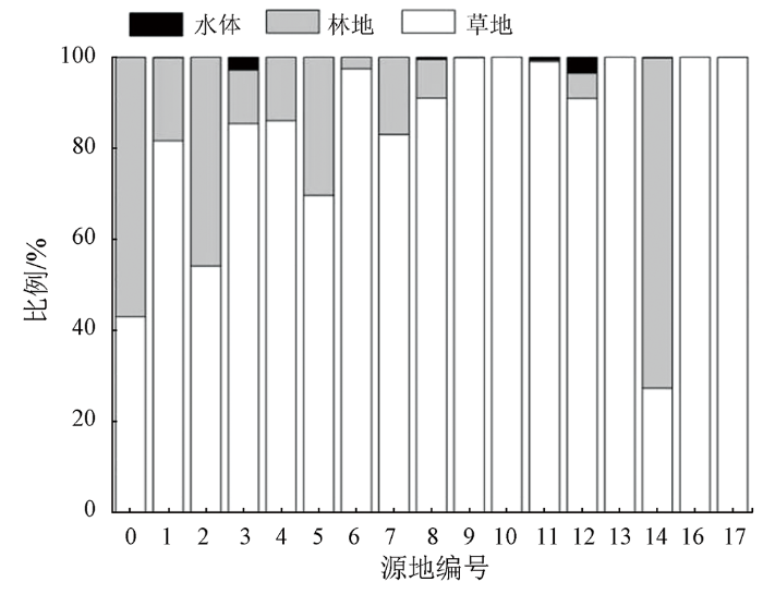
图4
生态源地内林水草构成比例
Fig.4
Proportion of forest, water and grass composition in ecological source area
3.1.2 生态源地等级划分
中卫市的生态源地可以分为3级(表3),其中,能量因子值在(0.70,1]的源地划为一级源地,包括南华山国家级自然保护区和沙坡头国家级自然保护区; 能量因子值在(0.30,0.70]的源地划为二级源地,包括香山寺草原自然公园和天湖湿地公园; 其他源地分布分散,类型众多,各源地面积有大有小,斑块碎片化程度比较严重,7号和11号源地面积最大,可其所在区域不是重要保护区域,实际情况中7号和11号源地所处矿产开发和水土保持区域,适合生物栖息的林地和水体区域较少,能量因子低,均划分为三级源地。15号源地呈长条形,将其归结为廊道。按照能量因子将生态源地分为3个等级的结果正好与自然保护区等级有很高的吻合度,说明生态源地分级结果合理。
表3 重要生态源地景观要素面积与比例
Tab.3
| 生态红线 源地编号 | 总面积/ hm2 | 面积百 分比/% | 能量因子 | 自然保护区 保护等级 |
|---|---|---|---|---|
| 0 | 14 390.52 | 4.55 | 0.10 | 三 |
| 1 | 7 063.96 | 2.23 | 0.07 | 三 |
| 2 | 29 293.02 | 9.26 | 0.70 | 一(国家级) |
| 3 | 5 986.16 | 1.89 | 0.05 | 三 |
| 4 | 4 594.56 | 1.45 | 0.04 | 三 |
| 5 | 23 011.42 | 7.28 | 0.13 | 三 |
| 6 | 6 283.52 | 1.99 | 0.05 | 三 |
| 7 | 74 378.28 | 23.52 | 0.12 | 三 |
| 8 | 4 436.65 | 1.40 | 0.04 | 三 |
| 9 | 16 038.31 | 5.07 | 0.08 | 三 |
| 10 | 6 244.36 | 1.97 | 0.50 | 二(省级) |
| 11 | 66 763.00 | 21.12 | 0.10 | 三 |
| 12 | 15 008.12 | 4.75 | 0.65 | 二(省级) |
| 13 | 1 139.62 | 0.36 | 0.01 | 三 |
| 14 | 8 505.66 | 2.69 | 1.00 | 一(国家级) |
| 16 | 9 561.29 | 3.02 | 0.05 | 三 |
| 17 | 12 119.91 | 3.83 | 0.05 | 三 |
3.2 生态廊道连通性特征分析
3.2.1 潜在生态廊道提取
图5
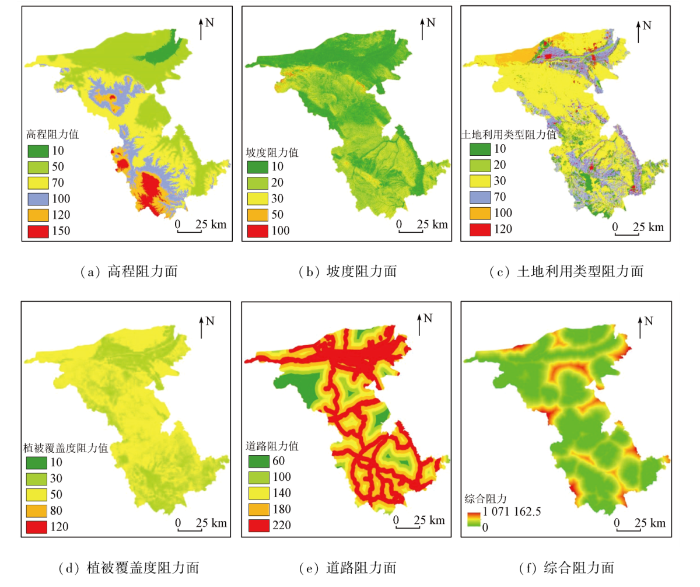
图5
单因子阻力面及综合阻力面
Fig.5
Single-factor resistance surface and comprehensive resistance surface
3.2.2 生态廊道等级划分
源地之间的生态引力值越高,表明生态源地间联系越紧密,物能流和信息流的强度会越高。基于重力模型,定量识别生态源地斑块间的相互作用力大小,计算得到生态源地间廊道的引力矩阵。通过对不同源地间引力按照大小进行排序,并生成累积阻力贡献率(图6)。两两源地之间引力差异较大,根据重力模型结果以及保证源地之间互相贯通的原则下筛选出重要廊道和一般廊道。参考前人研究结果[1,7,26]及研究区实际情况,选出累积贡献率达60%对应的源地间的廊道,即生态源地之间作用力大于或等于5的廊道,作为重要廊道,小于5的为一般廊道,共识别8条重要廊道,25条一般廊道; 网络中部廊道分布稀疏,南北区域廊道分布密集,从南到北连接的走廊多为长途走廊,整体上,形成了沿南北方向连接并贯穿中卫市的生态网络(图7)。
图6
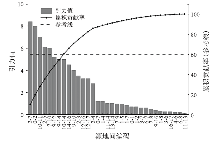
图6
源地间引力值及累积贡献率
Fig.6
Chart of gravitational value and cumulative contribution rate between source and earth
图7
3.3 中卫市生态网络结构优化
3.3.1 生态源地优化
中卫市草原退化、沙漠化、景观破碎化程度严重,除一级源地外,二级和三级源地植被覆盖度普遍偏低,孔隙、孤岛等景观类型较多。在今后发展中需要加强生态修复力度,其中,一级生态源地还需继续加强林水草的建设,提高源地植被覆盖度,并且要加强源地与周边源地、边缘类绿色基础设施的资源整合,拓展生态源地面积,打造连通成片的生态核心,巩固一级生态源地地位。二级生态源地可以通过整合周边孤岛及边缘资源、多植树造林,大力倡导退耕还林,还草,丰富生物多样性,减少生态景观破碎化、孤岛化现象。参考中卫市国土空间总体规划方案,未来还应以维护生态安全、保持自然生态系统的完整和功能为目的,重点做好各项保护工程,努力建设绿色生态屏障,以实现“北御防沙,中保护草,沿黄治水,南保水土”的生态安全格局。
3.3.2 生态廊道优化
生态廊道是物种迁移过程中需要克服阻力最小的路线,生态廊道的确定对物种间能量与信息交流至关重要,考虑到中卫市特殊的区域位置以及形成的生态网络结构,将呈带状的黄河源地、部分穿越中卫市的清水河以及生成的连接南北源地的重要廊道连接形成一级生态廊道,加强生态廊道适宜性建设,提高廊道间的连接性,形成了“四核三廊多点”的空间结构模式(图8)。
图8
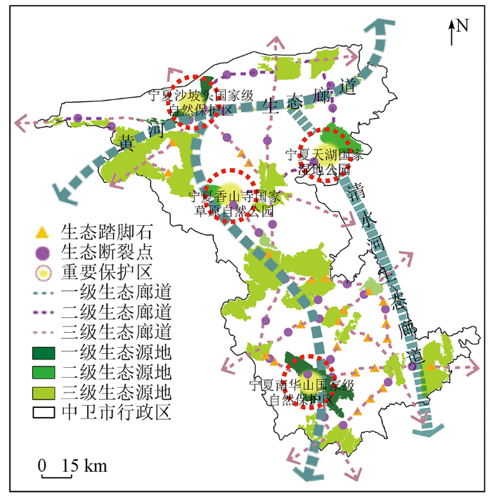
图8
中卫市“四核三廊多点”生态网络结构
Fig.8
Ecological network structure of “four cores, three corridors and multiple points” in Zhongwei City
3.3.3 生态节点优化
生态节点的构建,可提高生态系统整体性和稳定性。生态节点优化主要从以下2方面开展:
1)踏脚石建设。生态过程受到人类活动影响,生态廊道易发生断裂,建设生态踏脚石可以起到生物暂歇的作用,提高生态廊道的连通性。选取研究区内山脊线与生态廊道交点处作为踏脚石,经识别筛选后最终确定需建立24个踏脚石(图8)。
2)断裂点修复。在生态廊道中交通路网经过的区域易发生断裂,不利于生物迁徙及信息交流。将中卫市道路数据与生态廊道数据叠加求交,经识别筛选后确定需修复的生态断裂点38个(图8)。
3.3.4 优化后网络连通度提升情况评价
生态网络的稳定性对生态网络的有效性有直接的影响。采用网络分析法中α,β,γ指数对研究区规划前后的生态网络质量进行计算,规划前α,β,γ指数分别为0.21,1.33,0.48,优化后为0.23,1.38,0.50。α指数提升9.5%,β指数提升3.8%,γ指数提升4.2%,说明优化后的网络中闭合环路较多,源地之间的连通性较强,网络结构稳定,抗干扰能力更强,物质与信息流动更加灵活。
4 讨论与结论
4.1 讨论
1)干旱区生态源地识别与合理性验证。生态网络构建的关键在于生态源地的识别,目前尚未形成通用的源地识别方法。MSPA方法在生态源地识别方面有自己独特的优势而被广泛应用。通常而言,在湿润区以林地和水体为前景数据的研究较多,对草地的考虑较少,草地属于研究区的基质植被类型,是草原动物的重要栖息地,在旱区生态网络识别中,需要考虑动物草原栖息地的保护。考虑到生态红线重要作用,引入生态保护红线对核心区进行优化,进一步提升生态源地选择的合理性。
2)层级生态网络构建的关键问题。层级生态网络构建中,关键是对生态源地和生态廊道的等级合理确定的问题。本文将生态源地斑块的林地和水体占比之和的大小情况作为修正系数,对能量因子模型修正并标椎化处理,消除变量间的量纲关系,使处理结果更具有可比性。通过对方法模型的改进,采用等间距法划分为3个源地等级,优化了生态源地等级划分的科学性。生态廊道等级划分方面,本文通过将生态源地能量因子代替面积实现对重力模型的改进,提升生态廊道层级划分的科学性。
3)关于生态网络优化的视角。生态网络优化是为提高研究区内生态服务的流通性,使其网络结构更加合理完善。本文在前人仅通过MSPA-MCR方法构建生态网络结构的基础上,引入修正后的能量因子P和重力模型F分别对生态源地、生态廊道等级划分,形成源廊分层的MSPAP-MCRF模型组,使构建的生态网络层次结构更加清晰明确。仅从面域的生态源地到线域的生态廊道还远不足,本文还考虑点域的生态节点的构建,不仅可增强生物迁徙交流中的存活率,而且可加强网络的稳定性提高生态系统结构完整性。这种将“点-线-面”三者结合进行优化的网络构建方式,将为中卫市生态网络构建提供新思路。
4.2 结论
基于多源数据,采用MSPAP-MCRF模型,识别和划分生态源地及生态廊道,构建了中卫市层级生态网络,并提出优化策略。主要结论如下:
1)基于MSPA方法的干旱区生态源地识别中,将林地、草地和水体作为前景数据,并结合生态红线选择生态源地,修正的能量因子模型、改进的重力模型有助于生态源地等级划分和重要生态廊道筛选。
2)中卫市生态网络呈现为“四核三廊多点”的空间结构模式。其中生态源地17个,占研究区面积的22.33%,1级和2级共计4个源地的能量因子显著高于其他源地,形成“四核”; 潜在生态廊道33条,其中一级生态廊道3条,形成“三廊”,其他源地形成“多点”。
3)生态网络优化需要从生态源地质量提升、廊道加固、断裂点修复等方面开展。除1号、7号、9号源地之间的廊道较为稳定外,其他源地间连通性较低,生态网络稳定性较差,认为需要建立24个生态踏脚石,并发现38个亟待开展修复的生态断裂点。
4)通过踏脚石构建,提高了生态网络连通性,实现了对研究区生态网络的优化,优化后α指数、β指数、γ指数分别提升9.5%,3.8%和4.2%,增加了生态网络体系的完整性,有利于促进中卫市内生态物质及信息流动,提高生态系统价值,丰富生物多样性。
参考文献
基于MCR和重力模型下的厦门市生态空间网络构建
[J].
Construction of ecological space network in Xiamen City based on MCR and gravity model
[J].
基于MSPA分析方法的市域尺度绿色网络体系构建路径优化研究——以招远市为例
[J].
Research on construction path optimization of urban-scale green network system based on MSPA analysis method: Taking Zhaoyuan City as an example
[J].
基于MSPA和MCR模型的襄阳市生态网络变化研究
[J].
Variation of ecological network in Xiangyang City based on MSPA and MCR model
[J].
生态网络规划研究进展与发展趋势
[J].
Research progress and development trend of ecological network planning
[J].
马鞍山市生态网络识别与优化
[J].
Identification and optimization of ecological network in Ma’anshan City
[J].
基于“重要性-敏感性-连通性”框架的云浮市生态安全格局构建
[J].
DOI:10.11821/dlyj201703006
[本文引用: 1]

生态安全格局构建是保障城市生态安全,实现城市可持续性发展的重要途径,也是景观生态学研究的热点领域之一。生态源地识别与空间阻力面构建一直是生态安全格局构建中的技术难点。以广东省云浮市为例,从生态系统服务重要性、生态敏感性与景观连通性三个方面识别生态源地,利用DMSP/OLS夜间灯光数据修正基本生态阻力面,并运用最小累积阻力模型判定生态廊道,从而综合构建云浮市生态安全格局。研究表明:云浮市生态源地占全市总面积的36.47%,主要分布在西部与南部的山林地。云浮市生态廊道总长度为508.87 km,其中景观廊道总长度为315.58 km,组团廊道总长度为193.29 km,呈环状辐射分布于植被覆盖相对较好的山区地带。全市16个自然保护区基本都位于生态源地范围内。构建的“重要性—敏感性—连通性”框架可以为区域生态安全格局构建提供新思路,从而有效指引相关空间规划。
Constructing ecological security patterns in Yunfu City based on the framework of importance-Sensitivity-Connectivity
[J].
DOI:10.11821/dlyj201703006
[本文引用: 1]
Construction of ecological security patterns is an important approach to protecting urban ecological security and achieving urban sustainable development, which is one of key topics in the research of landscape ecology. The identification of ecological sources and the construction of spatial resistance surface have been the technical difficulties in the study of ecological security pattern. Yunfu city is the significant ecological hinterland of Guangdong Province with the backward economy, which is facing the pressure of ecological conservation as well as economic development. Thus, construction of ecological security pattern in Yunfu city can guide urban development and is also meaningful for protecting provincial ecological security. Based on GIS, ecological sources were identified from the aspects of ecosystem services' importance, ecological sensitivity, and landscape connectivity. On the basis of DMSP/OLS Nighttime Light data, ecological resistance surface was modified, and using minimum cumulative resistance model, ecological corridors were identified. The ecological sources with corridors constituted regional ecological security patterns. The results showed that, the area of ecological sources accounted for 36.47% of the total area, mainly distributed in mountainous area in western and southern Yunfu, which took forest as the main land cover type. The length of ecological corridors was 508.87 km, including 315.58 km landscape corridors and 193.29 km cluster corridors. It was also found that all the 16 nature reserves were in the range of ecological sources, and the constructed ecological security patterns and the layout of urban master planning complemented each other. The framework of importance-sensitivity-connectivity can provide a new method for the construction of regional ecological security patterns, and the study results can provide related planning with effective spatial guidance.
基于MSPA和MC模型的秦岭(陕西段)山地生态网络构建
[J].
DOI:10.13287/j.1001-9332.202105.012
[本文引用: 4]
快速的城市化发展破坏了生境斑块的连通性,而在应对此环境变化中,从斑块层构建区域生态网络的研究不足。本研究以秦岭(陕西段)为对象,采用形态学空间格局分析(MSPA)辨别生态源地,利用最小阻力模型(MCR)提取潜在生态廊道,构建秦岭生态网络;基于重力模型对生态网络内部斑块的重要性进行分级,并分析了网络的结构特征及景观构成。结果表明: 秦岭(陕西段)生态网络由10个生态源地、45条潜在生态廊道和38个脚踏石构成,生态源地总面积29686.15 km<sup>2</sup>;网络闭合度(0.11)、线点率(1.18)、网络连接度(0.42)、成本比(0.99)综合表明,网络结构中潜在生态廊道和生态节点的连通性较好,而源地间的连通程度低,构建网络的成本较高;重要生态廊道主要由林地、草地、耕地等景观类型构成,其中,林地面积最大,为571.00 km<sup>2</sup>,约占廊道总面积的89.2%,景观结构良好;在生态网络中应加强保护生态源地,优先建立并保护重要生态廊道和生态节点。研究结果可为秦岭生态环境保护与高质量发展提供科学的参考和依据。
Construction of ecological network in Qinling Mountains of Shaanxi,China based on MSPA and MCR model
[J].
基于生态网络的江苏省生态空间连通性变化研究
[J].
Analysis on changes of ecological spatial connectivity in Jiangsu Province based on ecological network
[J].
基于图论的景观图表达、分析及应用
[J].
DOI:10.13287/j.1001-9332.202010.014
[本文引用: 1]
景观结构和空间格局一直是景观生态学的核心问题,图论的应用为景观格局的分析提供了一种研究框架,基于图论的景观图逐渐被应用于生物多样性保护的连通性建模和景观规划的决策支持研究,景观图的表达、分析和应用已成为保护生物学和景观生态学研究的热点。本文首先介绍了景观图的图论基础,在Scopus数据库的基础上,检索了1993—2019年在标题、摘要和关键词中出现 “landscape graph”、“connectivity”和“network”词汇的257篇已发表的期刊论文。从年发文量、来源期刊、研究区域、研究机构、景观类型等方面分析了该领域的研究进展和发展趋势。分析发现,2017年之前,发表的期刊论文数量整体呈上升趋势,2017年之后年发文量逐年下降;主要研究力量集中在美国、西班牙、法国、加拿大和中国,发文量占到86.8%。大部分研究成果发表在“Landscape Ecology”、“Landscape and Urban Planning”和“Biological Conservation”期刊上。在研究内容上,景观图表达主要包括点的定义、边的度量和景观的模拟3方面,景观图分析研究包括分析指数、景观图划分两方面。我们重点关注了景观图在生物多样性保护、景观(生态网络)规划和管理、景观影响评价等科学与实践中的应用。基于图论的景观图通过帮助理解景观连通性变化、动物行为和栖息地保护,影响着保护科学和规划实践者。图论对保护科学和规划的影响来自于丰富的理论基础和成熟的研究方法,基于图论的景观图为景观结构和格局的生态学理解提供了跳板,并将继续成为全球研究人员和实践者的重要工具。
Representation,analysis and application of landscape graph based on graph theory
[J].
佛山市生态网络构建及优化
[J].
DOI:10.13287/j.1001-9332.202109.019
[本文引用: 1]
在快速城市化背景下,经济发达地区生境斑块破碎化问题尤为突出,生物多样性受到严重威胁,构建生态网络是连接生境斑块和保护生物栖息地的重要手段。本研究以发展较快的广东省佛山市为研究区域,利用连接度指数和形态学空间格局分析方法提取出生态源地,基于InVEST模型和最小累积阻力模型识别出潜在生态廊道,结合水文分析所提取出的辐射道,共同构建佛山市生态网络。通过增加生态源地和踏脚石、识别生态断裂点对生态网络进行优化,最后基于网络分析法和电路理论,从结构和功能两方面对优化前后的网络进行评价。结果表明: 佛山市生态网络由10个生态源地、8条重要廊道、37条一般廊道和11条辐射道构成。优化后新增生态源地7个、规划廊道17条、踏脚石13个、生态断裂点80个;优化后的生态网络闭合度指数、线点率指数、连接度指数分别为0.59、1.94、0.73,优化后的电流密度最大值由1.39升高至9.66,说明优化后的生态网络结构更加完善、连通性显著提升。
Ecological network construction and optimization in Foshan City,China
[J].
基于MSPA的福州绿色基础设施网络构建
[J].
Building green infrastructure network of Fuzhou using MSPA
[J].
区域生态安全格局构建研究进展与展望
[J].
DOI:10.11821/dlyj201703001
[本文引用: 1]
近年来,城市化的不断推进使得生态系统面临巨大压力甚至诱发生态灾难,而另一方面人类对于生态系统服务福祉的提升提出了新要求,因此经济发展和生态保护两者之间的矛盾不断激化。生态安全格局作为沟通生态系统服务和人类社会发展的桥梁,目前被视为区域生态安全保障和人类福祉提升的关键环节。在系统梳理生态安全格局与城市增长边界、生态网络、绿色基础设施和生态控制线等概念内涵异同的基础上,从热点区域、生态源地指标筛选、生态阻力面设置与修正、相关研究成果应用等方面阐释区域生态安全格局构建的近今研究进展,并指出当前研究的主要不足;同时提出了区域生态安全格局构建的重点方向,即生态安全格局构建的重要阈值设定、有效性评价、多尺度关联和生态过程耦合等四个方面。
Research progress and prospect on regional ecological security pattern construction
[J].
DOI:10.11821/dlyj201703001
[本文引用: 1]
In recent years, due to the continuous urbanization, natural ecosystems are under enormous pressure, even resulting in ecological catastrophes. Moreover, with the start of the New Urbanization and Ecological Civilization Construction work in China, the demand for improvement of ecosystem services to promote human well-being is increasing. Hence, there is an intensifying contradiction between economic development and ecological protection. Ecological security patterns (ESPs) as a bridge linking ecosystem services and human society, has become one of the effective ways of constructing the protective barriers for terrestrial ecosystems. The ESPs construction directly affects the balance between social development and ecological conservation, and thus it has become the key to solving ecological problems and improving human well-being. To improve and enrich the theory of ESPs, we systematically combed the similarities and differences in the connotation of ESPs and other four main relevant concepts, namely urban growth boundary (UGB), ecological networks (EN), green infrastructure (GI), and ecological control lines (ECL). Furthermore, a research paradigm of regional ESPs construction was proposed based on literature review. According to this paradigm, research progresses on four main aspects were summarized systematically. These four aspects were research hotspots, ecological sources identification, ecological resistance surface setting, and practical application. Then the main deficiencies were indicated and summarized as follows: (1) The research objects selected in previous studies were mainly concentrated in the province, city and county levels, and were more confined to a specific administrative region, lacking larger-scale researches across administrative boundaries. (2) The selection of ecological index was mostly based on the intrinsic characteristics of ecological patches, less considering its relationship with surrounding objects and its status and functions in the whole pattern. And many studies ignored the coupling of human ecological demand and ecological processes. (3) The ecological resistance surface was assigned mainly based on land-use type, which covered up the difference between the internal space of the same land use type. The amended case studies based on impervious surface area and nighttime light were still insufficient to reveal the real situation. (4) Most of the provided policy recommendations for the protection and management of ESPs were broad and lack of the effective real-time monitoring and comparison to ecological security pattern. Based on the main disadvantage of regional ESPs construction in the current researches, we put forward four main directions for future research: setting important thresholds, evaluating the effectiveness of ESPs, constructing ESPs across multi-scales, and coupling the ESPs with ecological processes.
太湖流域生态安全格局构建与调控——基于空间形态学-最小累积阻力模型
[J].
Construction and adjustment of ecological security pattern based on MSPA-MCR model in Taihu Lake basin
[J].
东部发达区生态安全格局构建——以苏南地区为例
[J].
Establishment of an ecological security pattern in the eastern developed regions:A case study of the Sunan District
[J].
基于源地综合识别与多尺度嵌套的徐州生态网络构建
[J].
DOI:10.31497/zrzyxb.20200817
[本文引用: 2]
传统生态网络构建时,生态源地的辨识多考虑生境斑块的质量和面积,较少考虑斑块生态系统服务功能与空间结构的影响;且多从一个尺度在相对封闭的系统单元内进行网络构建,缺乏尺度间的嵌套协调,易导致其结构性错位。通过构建“属性—功能—结构”三位一体的源地综合识别指标体系,基于最小费用路径、电路理论、移动窗口搜索法等方法,构建并叠置分析徐州都市区和主城区两个尺度的生态网络,并提出优化策略。结果表明:(1)两尺度生态源地重合面积79.85 km²,廊道重合长度158.42 km,重合面积45.68 km²,重叠区域对多尺度生态网络衔接稳定至关重要,需重点保护;对都市区至关重要却缺乏主城区下垫面支撑的8条廊道要优先修复。(2)识别都市区与主城区夹点分别为17处与18处,重合10处;障碍点8处与10处,重合5处。生物迁移关键区域高迁移阻力与大优化潜力并存,亟需优先修复。生物过程跨尺度的连续性要求采用多尺度级联框架协同应对生态问题。(3)基于“斑块—廊道—基质”理论从“点—线—面”三个角度提出徐州多尺度嵌套生态网络的优化策略。研究结果可为区域生态安全格局构建、国土综合整治与生态系统修复提供决策参考。
Construction of Xuzhou ecological network based on comprehensive sources identification and multi-scale nesting
[J].
DOI:10.31497/zrzyxb.20200817
[本文引用: 2]
The identification of ecological source in the traditional ecological network construction mostly considers the quality and area of habitat patches, but seldom considers the impact of ecosystem service function and spatial structure. Moreover, the traditional ecological network is mostly constructed in a relatively closed unit with only one scale, lacking nesting coordination, which will lead to the dislocation of ecological network structure between scales. To solve the above problems, an "Attribution-Function-Structure" index system is constructed to identify the ecological sources comprehensively. The Least-cost path method, the Circuit Theory and the Cyclic Window Search Method are adopted to form and identify ecological corridors, pinch points and barrier points respectively. From the Xuzhou metropolitan area and main urban area, two-scale ecological networks are constructed and overlapped to analyze its nested structure and coordination degree. The results showed that: (1) The coincident source areas at two scales is 79.85 km², the overlapping corridors length is 158.42 km, and overlapping corridors area is 45.68 km², which are important for the stability of the multi-scale ecological network connection and need to be protected. Meanwhile, 8 corridors that are vital to the metropolitan area but lack the underbelly support within the main urban area should be repaired as a priority. (2) A total of 17 and 18 pinch points are identified in the metropolitan area and the main urban area respectively, 10 of which overlapped; 8 and 10 barrier points are identified respectively as well, 5 of which overlapped. Contact ratio indicates that high migration resistance and large optimization potential coexist in key biological migration areas, which is in urgent need of repair. And the continuity of biological processes across scales need a multi-scale cascade framework to solve ecological problems coordinately. (3) Based on the theory of "Patch-Corridor-Matrix", a multi-scale nested ecological network optimization strategy is proposed from the three points about "Point-Line-Polygon". The research results can provide references for the regional ecological security pattern construction, land consolidation and ecosystem restoration.
基于复杂网络分析法的层级生态网络结构研究
[J].
Hierarchical ecological network structure based on complex network analysis
[J].
基于“压力-状态-响应模式”的安徽省临泉县生态安全格局构建
[J].
Construction of ecological security pattern based on ‘pressure-state-response model’ in Linquan County of Anhui Province
[J].
Mapping landscape corridors
[J].DOI:10.1016/j.ecolind.2006.11.001 URL [本文引用: 1]
GudiosToolbox:Universal digital image object analysis
[J].DOI:10.1080/22797254.2017.1330650 URL [本文引用: 1]
景观连接度的概念、度量及其应用
[J].
The concept and measurement of landscape connectivity and its applications
[J].
基于GIS的农村住区生态重要性空间评价及其分区管制——以兴国县长冈乡为例
[J].
Spatial assessment and zoning regulations of ecological importance based on GIS for rural habitation in Changgang Town,Xingguo County
[J].
基于模拟景观的城市森林景观格局指数选取
[J].
Selection of landscape metrics for urban forest based on simulated landscapes
[J].
基于MSPA与MCR模型的余江县生态网络构建
[J].
Developing ecological networks based on MSPA and MCR: A case study in Yujiang County
[J].
基于MCR模型的大别山核心区生态安全格局异质性及优化
[J].
DOI:10.31497/zrzyxb.20190408
[本文引用: 2]
以大别山核心区精准扶贫对象岳西县为研究单元,选择10个生态阻力因子建立生态安全评价指标体系,利用ArcGIS构建生态阻力面,应用空间数据探索分析方法(Exploratory Spatial Data Analysis,ESDA)、最小累积阻力模型(Minimum Cumulative Resistance,MCR)和重力模型对生态安全进行诊断和潜在生态廊道识别提取。研究表明:(1)岳西县生态安全较高及高等级区域占县域总面积37.79%,而较低及低等级区域占51.89%,整体呈现北低南高的空间特征,生态安全水平总体偏低。(2)ESDA分析显示,生态安全空间分布全局Moran's I指数为0.6374,LISA图显示岳西县生态安全等级主要以高高(HH)、低低(LL)两种聚集类型为主,在空间上呈明显的片状集聚分布特征。在此基础上,选择生境良好的自然保护区及大型风景区斑块为生态源,生成累积耗费阻力面,基于MCR最小累积阻力模型构建生态源之间的最小累积耗费路径,提取潜在生态廊道90条,生态节点103个,利用重力模型识别出21条重要潜在生态廊道,其中,一级和二级潜在生态廊道分别为13条和8条。(3)结合岳西县旅游产业空间发展规划,提出了“一环三带”生态网络框架空间布局模式及优化对策,该模式可作为岳西县生态经济产业发展格局的有效补充。
Analysis of spatial heterogeneity of ecological security based on MCR model and ecological pattern optimization in the Yuexi County of the Dabie Mountain area
[J].DOI:10.31497/zrzyxb.20190408 URL [本文引用: 2]
基于MSPA模型的北京市延庆区城乡生态网络构建
[J].
Construction of urban and rural ecological network in Yanqing District of Beijing based on MSPA model
[J].
基于MSPA-MCR模型的云南德昂族乡景观生态安全格局构建
[J].
Construction of landscape ecological security pattern of Deang ethnic group township in Yunnan based on MSPA-MCR model
[J].
