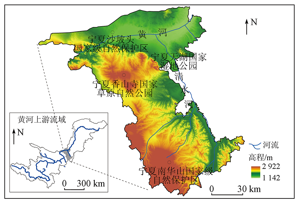
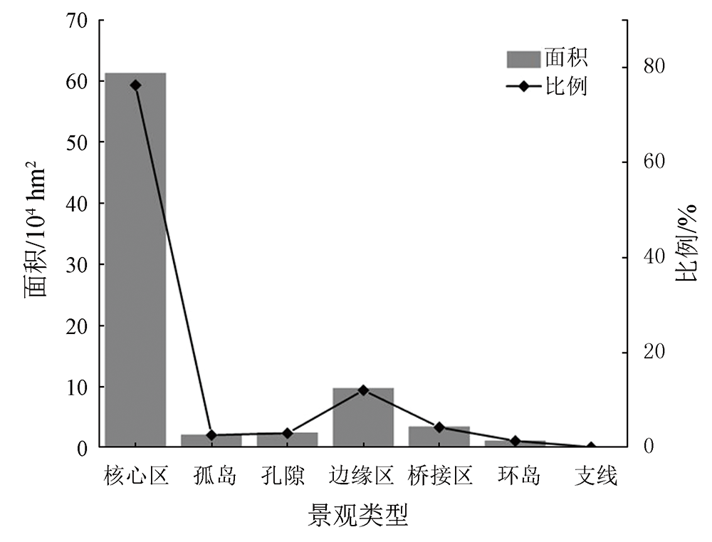
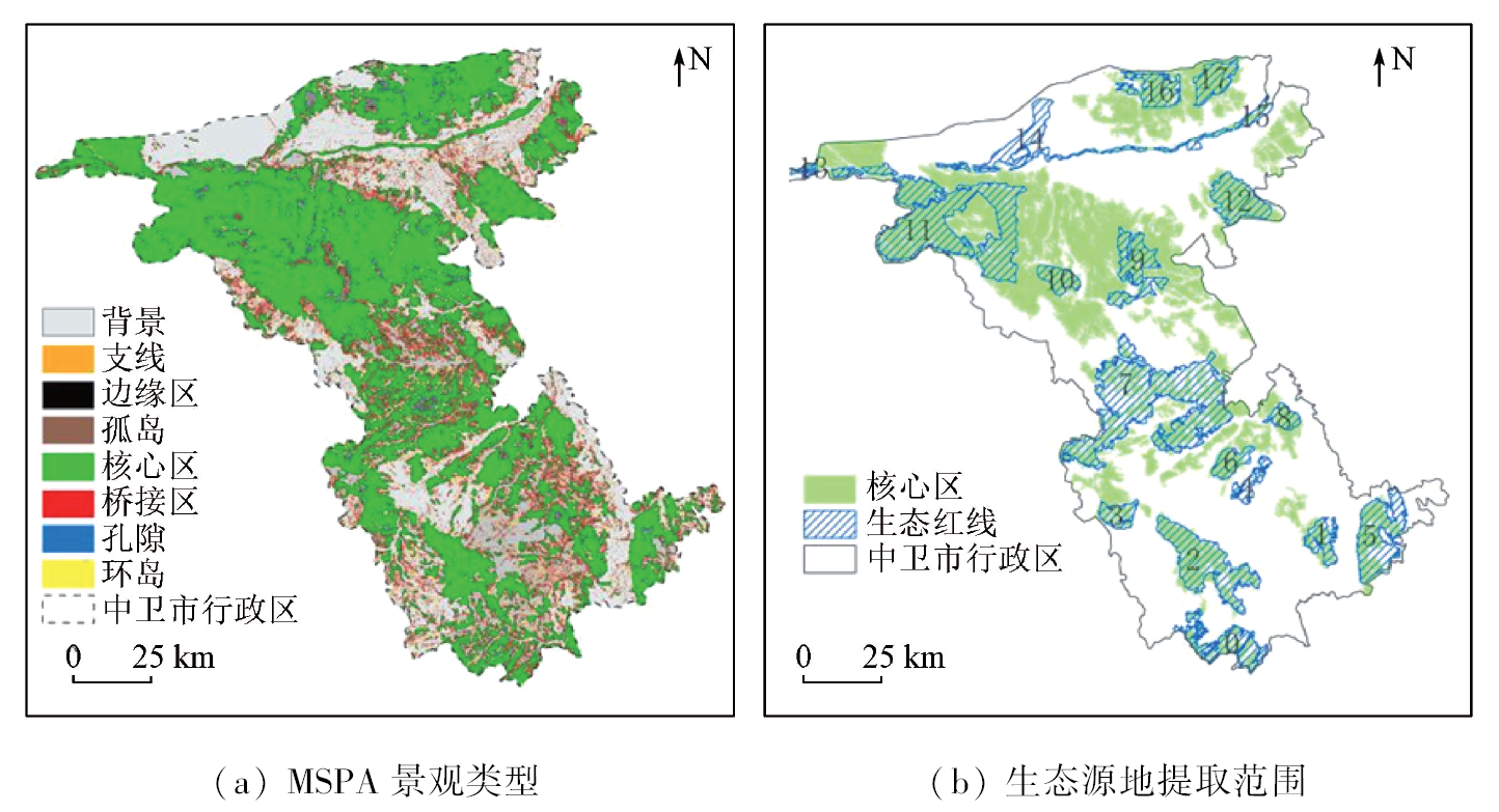
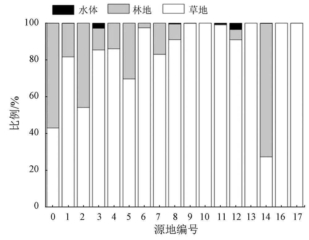
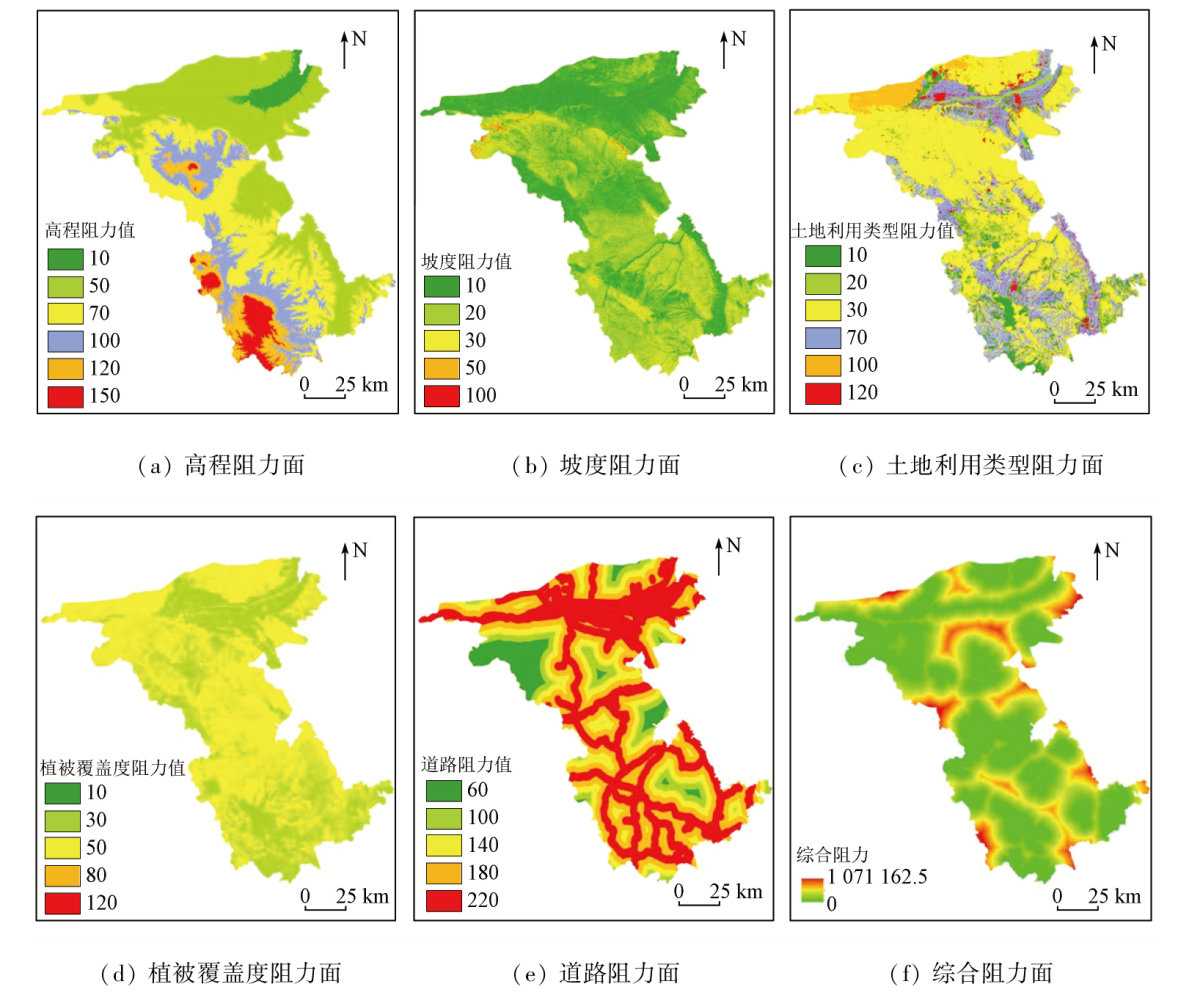
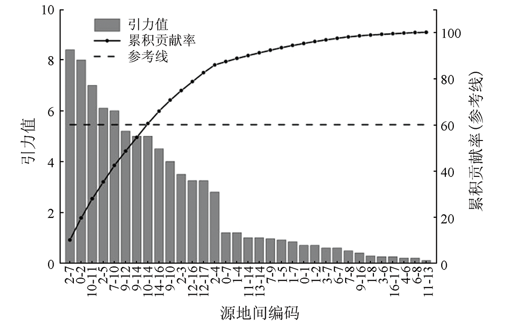
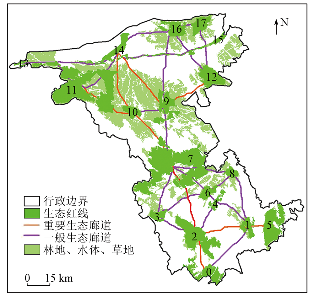
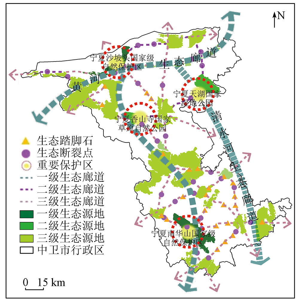
Based on data from multiple sources including Landsat8 OLI_TIRS remote sensing images, digital elevation model (DEM), road networks, and water system, as well as the corrected energy factor model and gravity model, this study improved the method for ecological network construction based on morphological spatial pattern analysis (MSPA) and the minimum cumulative resistance (MCR) model. Using the method, this study constructed and optimized a hierarchical ecological network for Zhongwei City, Ningxia. The results show that: ① The identification of ecological source areas in arid regions should be conducted using the data of woodland, grassland, and water bodies as foreground data and woodland and selecting ecological source areas based on ecological redlines; ② The ecological network of Zhongwei City presents a spatial structure mode characterized by four cores, three first-level ecological corridors, and multiple minor ecological source areas. Seventeen ecological source areas were identified, accounting for 22.33% of the study area. Among them, four grade-1 and -2 source areas exhibited significantly high energy factors, forming four cores. A total of 33 potential ecological corridors were identified, including three grade-1 ecological corridors; ③ Strategies for optimizing the ecological network, including improving ecological source areas’ quality, enhancing corridors, and restoring ecological breaking points. Except for the stable corridors connecting Nos. 1, 7, and 9 source areas, other source areas manifest poor connectivity, leading to low ecological network stability. Therefore, it is necessary to establish 24 ecological stepping stones. Furthermore, 38 ecological breaking points requiring urgent restoration were discovered; (4) The optimized ecological network demonstrates enhanced stability, with α, β, and γ indices elevated at 9.5%, 3.8%, and 4.2%, respectively. This network will promote the flow of ecological materials/information and biodiversity conservation.
刘园园, 马彩虹, 滑雨琪, 李聪慧, 杨航. 基于MSPAP-MCRF的干旱区层级生态网络构建与优化——以宁夏中卫市为例[J]. 自然资源遥感, 2024, 36(1): 67-76.
LIU Yuanyuan, MA Caihong, HUA Yuqi, LI Conghui, YANG hang. MSPAP-MCRF-based construction and optimization of a hierarchical ecological network for arid regions: A case study of Zhongwei City, Ningxia. Remote Sensing for Natural Resources, 2024, 36(1): 67-76.
Xu W Z, Huang S Y, Geng J W, et al. Construction of ecological space network in Xiamen City based on MCR and gravity model[J]. Journal of Northwest Forestry University, 2022, 37(2):264-272.
Gao Y, Mu H K, Zhang Y L, et al. Research on construction path optimization of urban-scale green network system based on MSPA analysis method: Taking Zhaoyuan City as an example[J]. Acta Ecologica Sinica, 2019, 39(20): 7547-7556.
Zhang Q, Guo Z W, Qi K, et al. Variation of ecological network in Xiangyang City based on MSPA and MCR model[J]. Journal of Hubei University(Natural Science), 2022, 44(2): 162-170.
Zhou Z H, Wang H H, Zhu Q S, et al. Identification and optimization of ecological network in Ma’anshan City[J]. Journal of Anhui Normal University (Natural Science), 2022, 45(1): 35-41.
Chen X, Peng J, Liu Y X, et al. Constructing ecological security patterns in Yunfu City based on the framework of importance-Sensitivity-Connectivity[J]. Geographical Research, 2017, 36(3):471-484.
doi: 10.11821/dlyj201703006
Chen N N, Kang S Z, Zhao Y H, et al. Construction of ecological network in Qinling Mountains of Shaanxi,China based on MSPA and MCR model[J]. Chinese Journal of Applied Ecology, 2021, 32(5): 1545-1553.
Zhang Q S, Li F X, Wang D W, et al. Analysis on changes of ecological spatial connectivity in Jiangsu Province based on ecological network[J]. Acta Ecologica Sinica, 2021, 41(8): 3007-3020.
Song L L, Qin M Z, Zhang P Y, et al. Representation,analysis and application of landscape graph based on graph theory[J]. Chinese Journal of Applied Ecology, 2020, 31(10): 3579-3588.
Shen Q W, Lin M L, Mo H P, et al. Ecological network construction and optimization in Foshan City,China[J]. Chinese Journal of Applied Ecology, 2021, 32(9): 3288-3298.
Peng J, Zhao H J, Liu Y X, et al. Research progress and prospect on regional ecological security pattern construction[J]. Geographical Research, 2017, 36(3): 407-419.
doi: 10.11821/dlyj201703001
Wang X R, Wan R R, Pan P P. Construction and adjustment of ecological security pattern based on MSPA-MCR model in Taihu Lake basin[J]. Acta Ecologica Sinica, 2022, 42(5): 1968-1980.
Wang Y Y, Jin X B, Shen C Z, et al. Establishment of an ecological security pattern in the eastern developed regions:A case study of the Sunan District[J]. Acta Ecologica Sinica, 2019, 39(7): 2298-2310.
Zhu J, Su J, Yin H W, et al. Construction of Xuzhou ecological network based on comprehensive sources identification and multi-scale nesting[J]. Journal of Natural Resources, 2020, 35(8): 1986-2001.
doi: 10.31497/zrzyxb.20200817
[16]
王戈, 于强, Yang D, 等. 基于复杂网络分析法的层级生态网络结构研究[J]. 农业机械学报, 2019, 50(7): 258-266,312.
Wang G, Yu Q, Yang D, et al. Hierarchical ecological network structure based on complex network analysis[J]. Transactions of the Chinese Society for Agricultural Machinery, 2019, 50(7): 258-266,312.
Yao X J, Hu Y, Li J L, et al. Construction of ecological security pattern based on ‘pressure-state-response model’ in Linquan County of Anhui Province[J]. Journal of Anhui Agricultural University, 2020, 47(4): 538-546.
[18]
Vogt P, Riitters K H, Iwanowski M, et al. Mapping landscape corridors[J]. Ecological Indicators, 2007, 7(2): 481-488.
doi: 10.1016/j.ecolind.2006.11.001
[19]
Vgot P, Ritters K. GudiosToolbox:Universal digital image object analysis[J]. European Journal of Remote Sensing, 2017, 50(1): 352-361
doi: 10.1080/22797254.2017.1330650
Wu C G, Zhou Z X, Wang P C, et al. The concept and measurement of landscape connectivity and its applications[J]. Acta Ecologica Sinica, 2010, 30(7): 1903-1910.
Xie H L, Li X B. Spatial assessment and zoning regulations of ecological importance based on GIS for rural habitation in Changgang Town,Xingguo County[J]. Acta Ecologica Sinica, 2011, 31(1): 230-238.
Liu C F, Li J Z, Li X M, et al. Selection of landscape metrics for urban forest based on simulated landscapes[J]. Chinese Journal of Applied Ecology, 2009, 20(5): 1125-1131.
Chen Z A, Quang D, Wei X J, et al. Developing ecological networks based on MSPA and MCR: A case study in Yujiang County[J]. Resources and Environment in the Yangtze Basin, 2017, 26(8): 1199-1207.
Huang M Y, Yue W Z, Feng S R, et al. Analysis of spatial heterogeneity of ecological security based on MCR model and ecological pattern optimization in the Yuexi County of the Dabie Mountain area[J]. Journal of Natural Resources, 2019, 34(4): 771-784.
doi: 10.31497/zrzyxb.20190408
Kong Y, Wang S Y. Construction of urban and rural ecological network in Yanqing District of Beijing based on MSPA model[J]. Journal of Beijing Forestry University, 2020, 42(7): 113-121.
Zhou Y, Shi C C, Liu Y, et al. Construction of landscape ecological security pattern of Deang ethnic group township in Yunnan based on MSPA-MCR model[J]. Journal of Southwest Forestry University(Social Sciences), 2022, 6(1): 54-62.
 2024, Vol. 36
  ), 马彩虹(