

0 引言
滑坡是指斜坡上的岩土体在重力作用下,由于自身结构或地质条件的不稳定性,出现沿坡面滑动破坏的地质现象[1]。诱发山体滑坡的因素众多,如强震、极端气候条件和人工作业等,都会削弱坡体土层稳定性,使山体发生剪切破坏,增加滑坡灾害的风险性。金沙江流域位于长江上游,沿岸地质构造复杂,断裂带与地震活动频繁,侵蚀强烈,因此形成褶皱高山与深切河谷地貌,沿主流孕育了一系列高位滑坡灾害,是中国典型的地质灾害高发区。传统的滑坡勘察手段,如地貌制图和目视航片解译等技术方法,滑坡识别精度高,但识别周期较长,对潜在的、滑动缓慢的滑坡,难以及时发现并预警,且只能获取滑坡上某点的位移信息,无法实现大区域滑坡形变探测,特别是面对高位、高速、高隐蔽性滑坡,依靠传统实地调查的方式难以进行,因此必须借助现代遥感技术进行大区域快速排查[2⇓⇓⇓⇓⇓-8]。
星载合成孔径雷达干涉测量技术(interferometric synthetic aperture Radar,InSAR)作为一种极具潜力的空间对地观测技术,利用合成孔径雷达(synthetic aperture Radar,SAR)相位信息实现对雷达视线向(line-of-sight,LOS)地表形变的高精度探测,有助于厘清滑坡灾害的空间分布规律及其影响机制,但容易受到形变量级、SAR成像几何特征、去相关因素以及大气效应的制约,导致形变提取精度受限[9]。为解决上述问题,引入以永久散射体干涉测量方法(permanent/persistent scatterer InSAR,PS- InSAR)、短基线集干涉测量(small baseline subset InSAR,SBAS-InSAR)和分布散射干涉测量(SqueeSAR)为代表的多时相InSAR技术(multi-temporal InSAR,MT-InSAR),能够很好地抑制因地形起伏、解缠困难和植被覆盖导致的失相干问题,得到有效地表形变信息。其中PS-InSAR技术选取在时间上散射特性相对稳定、回波信号较强的PS点作为观测对象,即人工建筑物和角反射器等,这在地形起伏较大、人工目标稀少的山区往往难以获取。SqueeSAR通过同质点选取算法增强时序InSAR协方差矩阵的估计精度,利用相位优化算法从协方差矩阵中恢复时序SAR影像的相位,得到精度、空间分辨率更高的时序形变产品,但计算效率低下,不适用于大范围精细监测。利用短时间段内保持较强相干能力的分布式散射体(distributed scatterers,DS)目标,其普遍存在于草地和沙地等自然界中,易于开展大范围精细监测[5-6]。因此本文采用多主影像的SBAS-InSAR时间序列方法,通过多轨道方向的InSAR形变探测,分析金沙江流域典型滑坡的形变特征及其影响因素,为流域地质灾害隐患监测预警和防治提供数据支撑。
1 数据与方法
1.1 研究区概况
金沙江流域地处青藏高原东缘,受横断山脉区域地形影响,展现为NS向的狭长地带,穿行于川、藏、滇三省区之间。具体位置如图1所示。境内地形复杂,高山深谷相间并列,断裂带广泛分布,地质构造运动强烈,是典型的高山峡谷地貌。受周边频繁地震及降雨影响,极易发生山体滑坡,形成堰塞湖堵塞河道。近年来曾发生过多次堵江事件,造成巨大的社会经济损失,属于地质灾害高发区,同时也是我国重要的地质灾害防治区。
图1
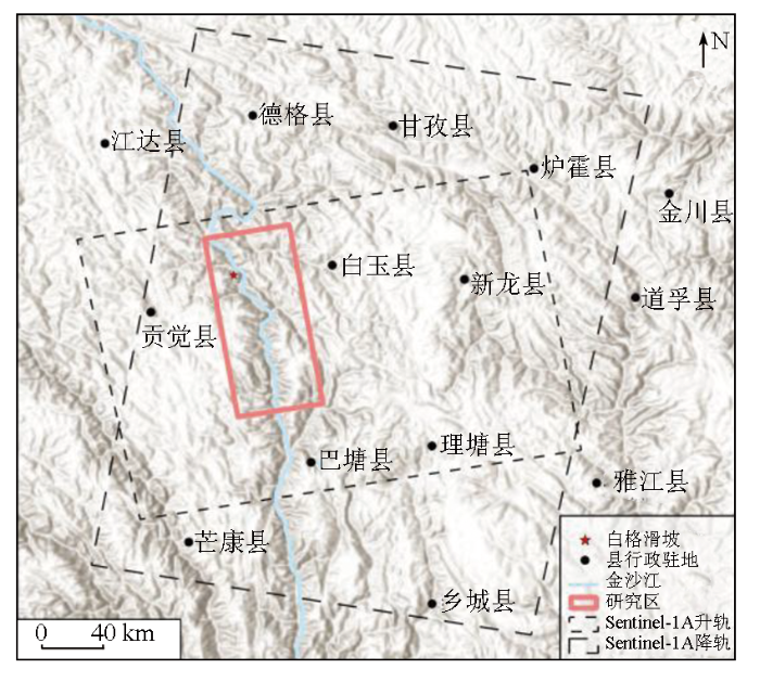
图1
研究区位置图和雷达卫星影像覆盖范围
Fig.1
Location of the study area and coverage of Radar satellite images
1.2 数据源及其预处理
表1 卫星SAR影像数据基本参数信息
Tab.1
| 参数 | Sentinel-1A升轨 | Sentinel-1A降轨 |
|---|---|---|
| 极化方式 | VV | VV |
| 入射角/(°) | 39.45 | 39.52 |
| 轨道号 | 99 | 33 |
| 幅号 | 1 280 | 488/493 |
| 所处波段 | C | C |
| 重访周期/d | 24 | 24 |
| 时间覆盖范围 | 20170902—20200724 | 20170921—20200719 |
| 影像数量/景 | 45 | 44 |
使用精密定轨(precise orbit determination,POD)星历数据修正观测影像的卫星轨道信息,生成单视复数(single look complex,SLC)影像,并根据研究区范围对SLC影像数据进行裁剪。由于金沙江流域位于高山峡谷地带,加之SAR侧视成像原理,SAR影像不可避免的出现几何畸变现象(包括叠掩、透视收缩和阴影等),导致部分坡体监测分辨率下降,监测精度变低甚至无法被监测,因此本文采用30 m空间分辨率的ALOS数字高程模型(digital elevation model,DEM)数据来进行差分干涉处理,有效去除地形相位带来的误差。设置空间阈值为2%,时间基线为120 d,用来减少几何失相干和DEM误差带来的不利影响,分别组成162和172组干涉对,时空基线图如图2所示。此外通过美国国家海洋和大气管理局(National Oceanic and Atmospheric Administration,NOAA),获取了德格县、巴塘县站点降雨数据,并作均值处理。河流月径流量数据则来源于国家水利部(www.mwr.gov.cn)统计年鉴。
图2
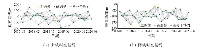
图2
SBAS-InSAR干涉组合时空基线
Fig.2
Spatiotemporal baselines of the interferometric combinations in SBAS-InSAR
1.3 时序SBAS-InSAR技术
SBAS方法最早由意大利学者Berardino等[4]于2002年提出并应用于地表形变监测,该方法可以有效克服时空基线过长导致的失相干,缓解大气效应及地形对差分的影响。其基本原理是通过短时空基线原则配准形成干涉子集,经外部DEM模拟去除平地效应及地形相位,对差分干涉相位进行空间滤波处理和相位解缠,然后对解缠相位进行优化和重去平,最后采用时空滤波估计和去除大气延迟相位,得到高精度的形变序列信息。相较于PS-InSAR技术,该方法解除了像元相位受单一强散射体控制,相位变化极易超出PS阈值范围的局限性,因此被广泛应用于自然地表形变监测[18⇓-20]。本文的SBAS数据预处理在ENVISARscape5.6.2软件平台中完成。
2 时序InSAR滑坡识别结果
2.1 时间序列InSAR分析
考虑到Sentinel-1A卫星升降轨影像覆盖范围的不同,以及白格滑坡的特殊性,降轨采用2个相邻幅号的轨道数据,来保证研究区的完整性。图3为流域范围内InSAR探测的滑坡年均形变速率,其中升轨Sentinel-1A数据获取的研究区形变速率为-142~80 mm/a(图3(a)),降轨Sentinel-1A数据获取的LOS向形变速率为-71~56 mm/a(图3(b))。升降轨结果对比发现升轨数据地表形变的空间分布更为显著,展现出丰富的隐患点信息,降轨数据结果可作为一种验证补充,建立数据互补优势[21⇓-23]。图3 Sentinel-1A形变数据结果显示,A和B这2处区域存在持续地表形变,其中A区是包含白格滑坡在内的形变区域,可以观测到其周边区域也存在显著地表形变;B区是由多个坡体组成的大型形变区,最大形变速率达-142 mm/a,存在较大安全隐患,应加强监测和预警。
图3
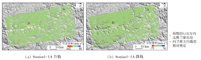
基于Sentinel-1A数据的InSAR技术探测到金沙江流域附近具有显著形变的斜坡体朝向多为EW向。升轨Sentinel-1A雷达易于探测坡向朝东斜坡上的滑坡隐患,若坡度过陡会伴随有阴影,而坡向朝西的斜坡体在SAR影像上会出现叠掩和透视收缩的几何畸变现象,降轨Sentinel-1A雷达监测效果则正好相反。因此采用联合升降轨数据的方法可以有效减少对滑坡的误判、漏判,提高地形陡峭山区滑坡隐患探测的准确性。
2.2 滑坡识别结果
形变监测结果作为一种参考依据,无法区分形变区域是否为潜在滑坡,为保证识别结果的准确性,通过高精度光学卫星影像和野外实地验证,对形变区域进行辅助识别和定性评价,共识别到9处滑坡,并将滑坡体按照坡体表面特征分为2类:一类为已经失稳过的老(古)滑坡,其识别标志主要为平滑的滑坡面且没有明显的切割沟壑,坡体上植被覆盖与周边差异显著等;而对于另一类正在孕育的潜在滑坡,则通过观察地表张拉裂缝、坡脚是否有泥土松脱垮塌或地面隆起等现象进行判定[24]。
3 典型滑坡分析
3.1 色拉滑坡
色拉滑坡地处昌都市贡觉县沙东乡下游,位于近NS向的金沙江缝合带内(图4(a)),前缘坡脚高程约2 650 m,后缘高程约3 340 m,相对高差700 m,依据光学影像解译标志和前人研究资料[25],判断该滑坡为岩质古滑坡堆积体。根据滑坡坡面变形特征将其分为后缘下错变形区Ⅰ,中部拉裂变形区Ⅱ,前缘滑塌应力集中区Ⅲ这3个区域。其中Ⅲ包括前部滑塌变形区(Ⅲ-1)和前部应力集中区(Ⅲ-2)。光学影像显示该滑坡后缘存在多个错落面,堆积物以松散碎石土为主(图4(e)),中部发育多条平行拉裂缝,而滑坡前缘因受江水侵蚀,形成了连续的次级滑动后壁和张拉裂缝(图4(d)),图4(b)为该滑坡20170902—20200724 Sentinel-1A升轨影像LOS方向形变速率,结果显示该滑坡前缘中部和右侧均存在形变区域,局部滑塌区形变量级较大,明显失相干,最大变形速率达-85 mm/a。在滑坡体Ⅲ区域选择特征点P1,P2和P3,绘制特征点2017—2020年升轨数据时间序列形变曲线,如图4(c)所示,累计形变量为200 mm。形变曲线显示该滑坡目前仍处于匀速变形阶段。
图4
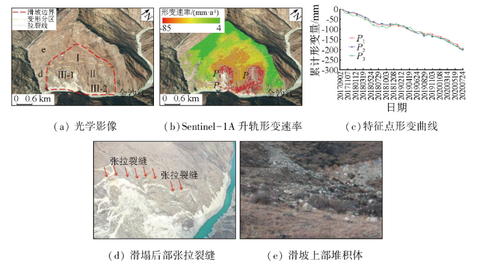
图4
色拉滑坡隐患解译及野外照片
Fig.4
Interpretation of hidden dangers of Sela landslide and field photos
3.2 沙东(雄巴)滑坡
沙东(雄巴)滑坡位于金沙江断裂带分支东侧约6 km处,滑坡平面形态呈圈椅状,强变形区范围约为2 730 m×2 100 m,综合光学卫星影像和前人研究资料[18],判断该滑坡为巨型堆积古滑坡体(图5(a))。根据滑坡坡面变形特征将其分为Ⅰ,Ⅱ和Ⅲ这3个子区,光学影像显示该滑坡前缘和后缘均存在局部变形,其中滑坡前缘受金沙江水位掏蚀影响出现跨塌岸,右前部出现多条垂直坡向裂缝,局部形成多级下错台坎,滑坡中后部存在外凸型张拉裂缝,局部形成反倾台地,两侧发育冲沟,冲沟两侧局部滑塌较显著,图5(e)—(f)为实地拍摄的裂缝和反倾台地照片。该滑坡体主要由碎块石土、碎石土、卵砾石土、云母石英片岩等组成。图5(b)—(c)分别为Sentinel-1A升降轨数据获取的LOS方向形变速率结果。Sentinel-1A升降轨形变速率结果均表现出了明显的形变信息,其中以升轨影像更为显著。形变结果显示,2017年9月—2020年7月期间,该滑坡处于持续变形状态,最大变形速率达-115 mm/a。在滑坡显著形变区选取P1,P2和P3这3个特征点,分析其时间序列形变量(图5(d)),其中P1平均形变速率为93 mm/a,累计形变量为270 mm; P2平均形变速率为80 mm/a,累计形变量为231 mm;P3平均形变速率为71 mm/a,累计形变量为204 mm;时序形变结果显示,沙东(雄巴)滑坡目前整体处于不稳定状态,尤其中部及前部存在大范围的变形破坏迹象,为滑坡中后部提供高陡临空面,在暴雨和地震情况下可能发生大规模滑动破坏,堵江风险较大。
图5
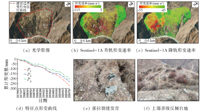
图5
沙东(雄巴)滑坡隐患解译及野外照片
Fig.5
Interpretation of hidden dangers of Shadong (Xiongba) landslide and field photos
3.3 尼马寺堆积体滑坡
尼马寺堆积体属于典型的缓倾坡内型滑坡[26],地处横断山脉、金沙江流域河谷地带,强变形区范围约为2 000 m×1 400 m,坡度约25°~35°,滑坡体岩体结构破碎疏松,岩性多样。
根据滑坡坡面变形特征将其分为Ⅰ,Ⅱ和Ⅲ这3个子区(图6),其中Ⅰ和Ⅱ是目前主要发育变形区,变形Ⅰ区位于堆积体右侧的冲沟沟道内部及后缘,主要为沟道碎块石堆积,且冲沟中后部发育有横向张拉裂缝(图6(d))。变形Ⅱ区位于堆积体的中下部,已发育多条拉裂缝,前缘可见拉裂缝连通(图6(e)),下部存在局部滑动后壁,目前处于蠕滑变形阶段。InSAR技术探测到该滑坡体最大形变速率为-142 mm/a。在滑坡体上选取3个特征点P1,P2和P3,分析其时间序列形变量(图6(c)),其中P1平均形变速率为82 mm/a,累计形变量为238 mm;P2平均形变速率为94 mm/a,累计形变量为272 mm;P3平均形变速率为120 mm/a,累计形变量为348 mm。时序形变分析结果显示,该堆积体滑坡对应的Ⅱ区形变速率和累积形变量要显著大于Ⅰ区和Ⅲ区,是滑坡形变最强烈的区域。考虑到地震、降雨对堆积体斜坡的影响,且该堆积体目前已发育有2处较明显的变形迹象区,加之堆积体胶结程度较差,因此在受到金沙江河道的持续侵蚀及极端天气条件影响,可能会发生局部失稳,对下方金沙江河道产生影响,建议架设全球定位系统(global positioning system,GPS)观测站等现场监测设备进行持续监测。
图6
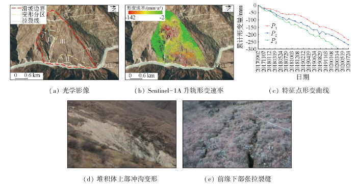
图6
尼马寺堆积体滑坡隐患解译及野外照片
Fig.6
Interpretation of hidden danger of landslide in Nima Temple accumulation and field photos
4 形变因素分析
图7
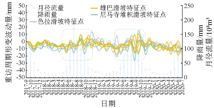
图7
重访周期形变波动曲线与降雨量、径流量的关系
Fig.7
Revisiting the relationship between periodic deformation fluctuation curves and rainfall runoff
图8
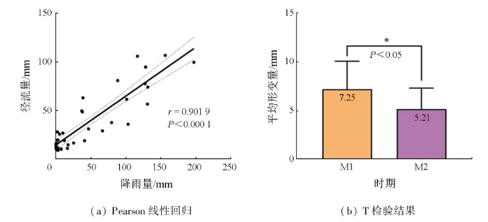
图8
相关系数图及独立样本T检验
Fig.8
Correlation coefficient graph and Independent samples t-test
5 结论
本文采用Sentinel-1A雷达数据,基于SBAS-InSAR时序分析方法,对白格滑坡及其下游100 km范围内的滑坡隐患进行了早期识别研究,获取了该区域2017年9月—2020年7月共3 a的时序形变场,探测出金沙江流域部分高位滑坡体分布及其范围,解算并分析了滑坡体的时空演化规律及影响其形变的主要因素,主要得到以下结论和认识:
1)InSAR能够在大区域范围内监测毫米级的地表形变,提供滑坡形变特征及时空演化过程,特别在高位、集中分布式滑坡灾害的识别中独具优势,但其探测精度受限于复杂山区的地形起伏程度、大气及植被覆盖等因素,且只能获取雷达LOS上的一维投影。通过联合Sentinel-1A升降轨数据进行滑坡识别监测,可以在一定程度上减少对滑坡区域的误判和漏判,但在降轨数据结果中仍存在因环境因素导致的错判,所以在实际应用中应结合光学影像和实地调查对结果进行补充验证,进行综合研判。
2)金沙江河道沿岸的滑坡多为EW向,与LOS一致,利用Sentinel-1A升降轨影像能够很好地进行滑坡识别。研究区共探测出2处存在持续地表形变的滑坡区域,其中以升轨影像更为明显,这是由于形变体量较大的滑坡体朝向为东,易于在升轨影像提取到具有稳定散射特性的高相干点目标,进行时序相位信号分析,而降轨影像可以作为一种补充手段,用于判定滑坡体表面的形变走向。
3)滑坡前缘因受河水侵蚀影响,形变量和形变速率会明显大于滑坡中部及后缘区域。结合光学影像,利用SBAS-InSAR时序技术,通过在滑坡体上选取特征点的方式,获得单个滑坡体近3 a的累计形变量及形变速率,对滑坡体特征点形变特征与降雨和径流因子关系进行分析,发现滑坡体在雨季丰水期阶段形变相对于非雨季枯水期有明显增大的现象,金沙江流域滑坡体形变与降雨和径流因子存在相关性。
参考文献
Landslide identification and monitoring along the Jinsha River catchment (Wudongde reservoir area),China,using the InSAR method
[J].
基于天-空-地一体化的重大地质灾害隐患早期识别与监测预警
[J].
Integrated space-air-ground early detection,monitoring and warning system for potential catastrophic geohazards
[J].
A new algorithm for surface deformation monitoring based on small baseline differential SAR interferograms
[J].
InSAR变形监测方法与研究进展
[J].
DOI:10.11947/j.AGCS.2017.20170350
[本文引用: 2]

变形监测是星载InSAR技术应用最为成熟的领域之一。本文首先介绍了InSAR变形监测的基本原理和卫星数据来源;然后对InSAR变形监测方法进行了系统性的分类,分析了D-InSAR、PS-InSAR、SBAS-InSAR、DS-InSAR和MAI等方法的技术特点和适用范围;进而从应用的角度分析了InSAR技术在城市、矿山、地震、火山、基础设施、冰川、冻土和滑坡等领域的研究现状和不足之处;最后总结出InSAR变形监测在多维形变和低相干区测量、大气和轨道误差去除和精度评定等方面的前沿问题。
Research progress and methods of InSAR for deformation monitoring
[J].
DOI:10.11947/j.AGCS.2017.20170350
[本文引用: 2]
Deformation monitoring is one of the most mature applications of space-borne InSAR technique. Firstly, we introduce the basic principle of InSAR in the monitoring of deformation and the current SAR satellites. The deformation monitoring methods of InSAR are then classified into the groups of D-InSAR, PS-InSAR, SBAS-InSAR, DS-InSAR and MAI, which are analyzed in the aspects of technical features and application scopes. Subsequently, we analyze the research progress and deficiencies of InSAR in the investigation of urban, mining area, earthquake, volcano, infrastructure, glacier, permafrost and landslide. Finally, some advanced academic problems such as deformation monitoring in multi-demension and low coherence area, atmospheric and orbital errors mitigation, and accuracy assessment are concluded.
InSAR技术在滑坡灾害中的应用研究进展
[J].
Application of InSAR technology in landslide hazard:Progress and prospects
[J].
对地质灾害隐患早期识别相关问题的认识与思考
[J].
Understanding and consideration of related issues in early identification of potential geohazards
[J].
Landslide detection and inventory updating using the time-series InSAR approach along the Karakoram Highway,Northern Pakistan
[J].
DOI:10.1038/s41598-023-34030-0
PMID:37161025
[本文引用: 1]
Karakoram Highway (KKH) is frequently disrupted by geological hazards mainly landslides which pose a serious threat to its normal operation. Using documented inventory, optical imagery interpretation, and frequency-area statistics, the features of slope failure, the spatial distribution, and their link to numerous contributing factors have all been effectively explored along the KKH. An updated inventory for the area was recreated using the interferometric synthetic aperture radar (InSAR) persistent scatterer (PS) technology to further investigate millimetre-accurate measurements of slope deformation (V). Utilizing the PS approach, Sentinel-1 data from Jan 2018 to Jan 2022 were processed by which we obtained a deformation rate (V) that varies between 0 and 364 mm/year. A total number of 234 landslides were cited from the literature and classified while 29 new potential landslides were detected and several pre-existing landslides were redefined by the InSAR approach, which was incorporated to generate an updated landslide susceptibility model with 86.6% of prediction precision in the area under curve method. As previous studies done by applying the InSAR technique incorporated a short span temporally and they missed some highly deforming zones like Budalas and Khanabad landslides, contain mean velocities > 50 mm/yr, which we studied individually in this work. In this study, a comprehensive application of the InSAR technique to assessing its performance in detecting and analysing landslides has been applied. The deformation velocity (V) model shows high displacement in some regions, which needed to be further investigated by geoscientists, and the updated developed landslide inventory and susceptibility map can be used for land use planning and landslide mitigation strategies.© 2023. The Author(s).
金沙江巧家巨型古滑坡发育特征及其形成条件
[J].
Development characteristics and forming conditions of Qiaojia giant ancient landslide in Jinsha River
[J].
金沙江上游特米古滑坡堰塞湖成因与演化
[J].
DOI:10.13745/j.esf.sf.2020.9.9
[本文引用: 1]
金沙江上游巴塘—中咱河段位于青藏高原东南缘,该河段两岸岸坡发育众多的大型古滑坡,且部分古滑坡曾堵塞金沙江形成了堰塞湖,特米大型古滑坡堰塞湖是其中之一。关于特米古滑坡堰塞湖的形成与演化过程目前尚未见有过详细的报道。本文在野外调查的基础上,结合遥感影像解译和年代学测试,对特米古滑坡堰塞湖的地貌和沉积特征进行了详细研究,并对其形成与演化过程进行了分析。研究结果表明,特米古滑坡堰塞湖很可能是由该地区的古地震活动触发大型滑坡并堵塞金沙江形成的,最大湖面面积约为1.42×10<sup>7</sup> m<sup>2</sup>,库容蓄水量约为1.46×10<sup>9</sup> m<sup>3</sup>。该古堰塞湖的形成时间约为1.8 ka BP,其溃决消亡的时间约为1.4 ka BP,溃决洪峰流量约为55 858 m<sup>3</sup>/s,该滑坡堰塞湖持续稳定了约400年的时间。
The origin and evolution of the Temi paleolandslide-dammed lake in the upper Jinsha River
[J].
DOI:10.13745/j.esf.sf.2020.9.9
[本文引用: 1]
In the Batang-Zhongza segment of the upper Jinsha River on the southeastern margin of the Tibetan Plateau, major plaeolandslides were widely developed along either bank of the river, some had blocked the river flow to form dammed lakes. The large scale Temi paleolandslide-dammed lake is one of them, however, its origin and evolution have not yet been reported. In this study, we investigated the geomorphology and sedimentology of the Temi paleolandslide-dammed lake through field investigation, remote sensing interpretation and optical stimulated luminescence dating, and analyzed its origin and evolutionary processes. The study results indicated that the Teimi paleolandslide-dammed lake was caused by a major landslide blocking the Jinsha River, triggered by the intensive paleoearthquakes in this area. The maximum lake area and volume were about 1.42×10⁷ m2 and 1.46×10⁹ m3, respectively. The formation time of this paleolake was ~1.8 ka BP, and the time of its breaching was ~1.4 ka BP, with a peak discharging of 55858 m3/s, implying that the Temi paleolandslide-dammed lake were stable for about 400 years.
Chronology of relict lake deposits around the Suwalong paleolandslide in the upper Jinsha River,SE Tibetan Plateau:Implications to Holocene tectonic perturbations
[J].
基于光学遥感像素偏移量的金沙江流域2018年白格滑坡演变过程
[J].
Evolution of the 2018 Baige landslides revealed by optical remote sensing pixel offsets in Jinsha River basin,China
[J].
2018年10月和11月金沙江白格两次滑坡-堰塞堵江事件分析研究
[J].
Study on successive landslide damming events of Jinsha River in Baige Village on Octorber 11 and November 3,2018
[J].
青藏高原交通廊道沿线Sentinel-1影像几何畸变与升降轨适宜性定量分析
[J].
Quantitative analysis of Sentinel-1 imagery geometric distortion and their suitability along Qinghai-Tibet plateau traffic corridor
[J].
高山峡谷区滑坡灾害隐患InSAR早期识别——以雅砻江中段为例
[J].
Early identification of potential landslide geohazards in alpine-canyon terrain based on SAR interferometry:A case study of the middle section of Yalong River
[J].
卫星雷达遥感在滑坡灾害探测和监测中的应用:挑战与对策
[J].
Application of satellite radar remote sensing to landslide detection and monitoring:challenges and solutions
[J].
基于SBAS-InSAR技术的西藏雄巴古滑坡变形特征
[J].
Study of the deformation characteristics of the Xiongba ancient landslide based on SBAS-InSAR method,Tibet,China
[J].
基于时间序列InSAR分析的西部山区滑坡灾害隐患早期识别——以四川丹巴为例
[J].
Early detection of landslide hazards in mountainous areas of west China using time series SAR interferometry:A case study of Danba,Sichuan
[J].
Early identification and influencing factors analysis of active landslides in mountainous areas of southwest China using SBAS-InSAR
[J].
多时相InSAR技术及其在滑坡监测中的关键问题分析
[J].
Multi-temporal InSAR techniques and their challenges in the landslides monitoring
[J].
基于SBAS-InSAR技术的深切割高山峡谷区滑坡灾害早期识别
[J].
Early identification of landslide hazards in deep cut alpine canyon using SBAS-InSAR technology
[J].
金沙江下游永善段隐蔽性滑坡隐患综合遥感识别
[J].
Comprehensive remote sensing identification of hidden landslides in Yongshan section of lower Jinsha River
[J].
光学遥感与InSAR结合的金沙江白格滑坡上下游滑坡隐患早期识别
[J].
Early detection of landslides in the upstream and downstream areas of the Baige landslide,the Jinsha River based on optical remote sensing and InSAR technologies
[J].
金沙江结合带高位远程滑坡失稳机理及减灾对策研究——以金沙江色拉滑坡为例
[J].
Instability mechanism and disaster mitigation measures of long-distance landslide at high location in Jinsha River junction zone:A case study of Sela landslide in Jinsha River,Tibet
[J].
一种基于多源遥感的滑坡防灾技术框架及其工程应用
[J].
A technical framework of landslide prevention based on multi-source remote sensing and its engineering application
[J].
Monitoring seasonal movement characteristics of the landslide based on time-series InSAR technology:The Cheyiping landslide case study,China
[J].
Revealing the time lag between slope stability and reservoir water fluctuation from InSAR observations and wavelet tools:A case study in Maoergai Reservoir (China)
[J].
甘肃省舟曲县城周边活动滑坡InSAR探测
[J].
Active landslides detection in Zhouqu County,Gansu Province using InSAR technology
[J].
Landslide susceptibility evaluation integrating weight of evidence model and InSAR results,west of Hubei Province,China
[J].
