InSAR-based detection and deformation factor analysis of landslide clusters in the Jinsha River
WU Dehong1(), HAO Lina1(), YAN Lihua1, TANG Fengshun1, ZHENG Guang2
1. School of Earth Sciences, Chengdu University of Technology, Chengdu 610059, China 2. State Key Laboratory of Geohazard Prevention and Geoenvironment Protection, Chengdu 610059, China
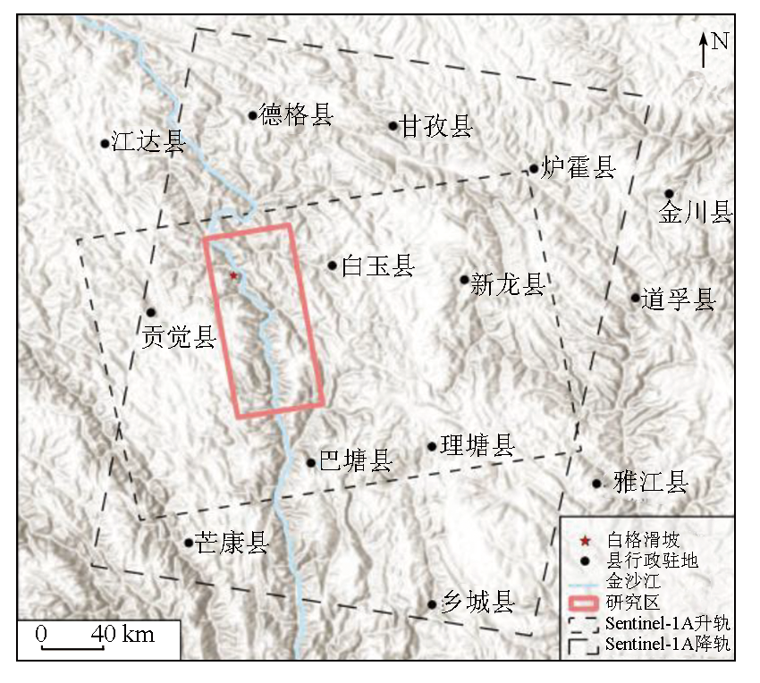
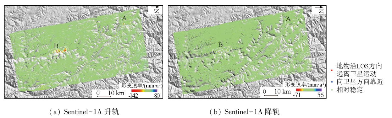
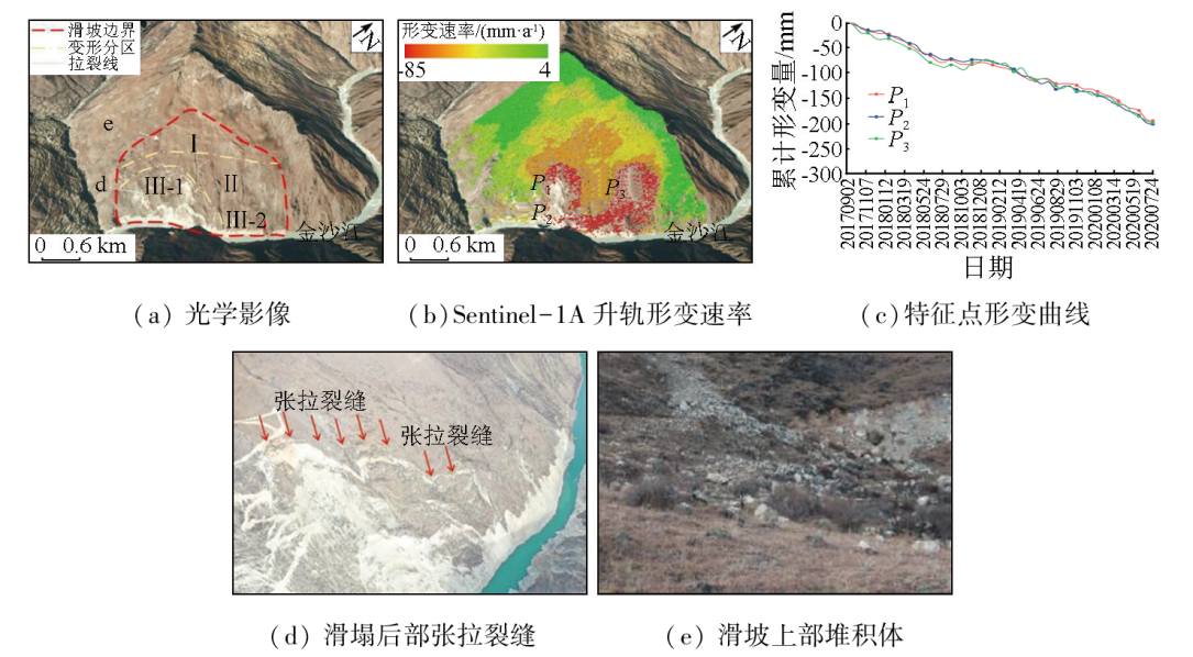
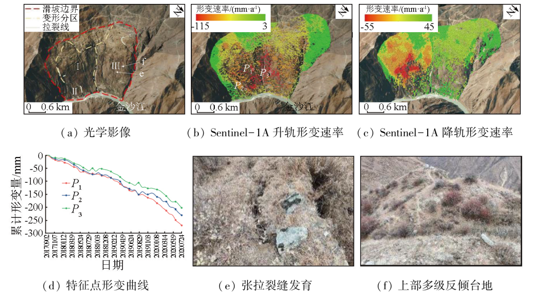
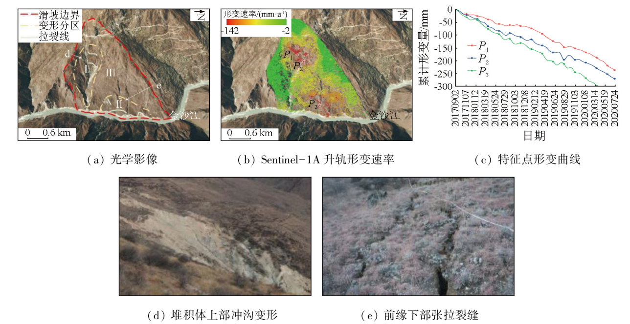
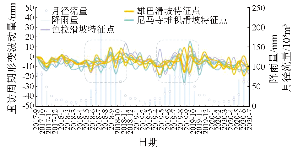
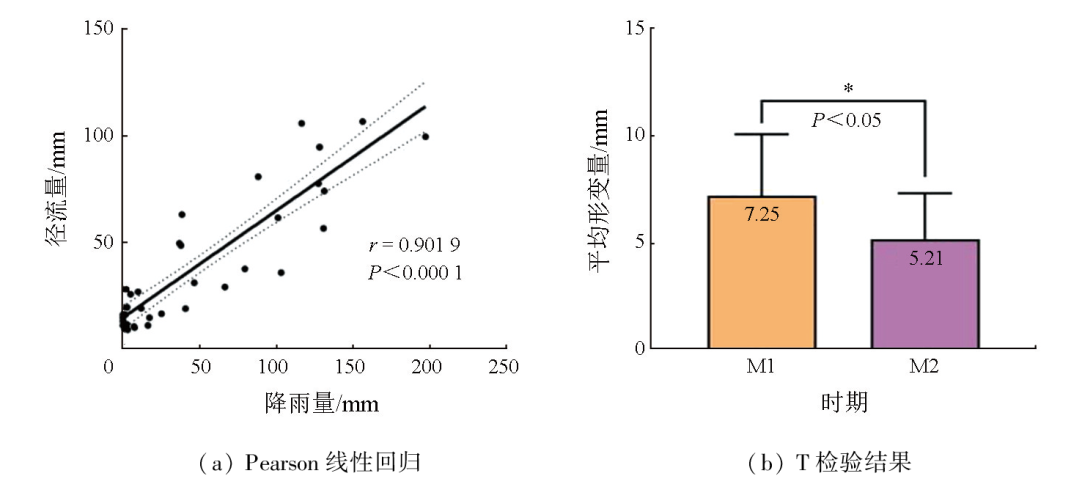
The Jinsha River basin is a typical area with a high incidence of geologic hazards in China. To accurately identify the potential landslide hazards in the basin, this study processed the data of Sentinel-1A’s ascending and descending orbits using the SBAS-InSAR technique. From two detection directions, it conducted early landslide identification and deformation monitoring of the Baige landslide on the bank of the Jinsha River and its lower reaches covering approximately 100 km. The results show that: ① The combined detection based on Sentinel-1A’s ascending and descending orbits effectively reduced the interference of geometric distortions, enabling the identification of long-term creep hazard sites; ② The deformation rates along the line-of-sight (LOS) of ascending and descending orbits ranged from -142 to 80 mm/a and -71 to 56 mm/a, respectively. Combined with the visual interpretation of optical remote sensing images, two large landslide clusters consisting of nine landslides were detected; ③ The analysis of surface deformation characteristics was conducted on three typical landslides: the Sela landslide, the Shadong (Xiongba) landslide, and the Nimasi talus slide. The analysis results reveal that the maximum deformation was associated with the peak rainfall and river runoff, which constituted the significant factors influencing landslide deformation. The results of this study serve as a reference for the prediction, early warning, prevention, and control of basin-scale geologic hazards in flood seasons.
Huang R Q, Xu Q, Deng H, et al. Catastrophic landslides in China[M]. Beijing: Science Press, 2008:553.
[2]
Zhao C Y, Kang Y, Zhang Q, et al. Landslide identification and monitoring along the Jinsha River catchment (Wudongde reservoir area),China,using the InSAR method[J]. Remote Sensing, 2018, 10(7):993.
Xu Q, Dong X J, Li W L. Integrated space-air-ground early detection,monitoring and warning system for potential catastrophic geohazards[J]. Geomatics and Information Science of Wuhan University, 2019, 44(7):957-966.
[4]
Berardino P, Fornaro G, Lanari R, et al. A new algorithm for surface deformation monitoring based on small baseline differential SAR interferograms[J]. IEEE Transactions on Geoscience and Remote Sensing, 2002, 40(11):2375-2383.
Zhu J J, Li Z W, Hu J. Research progress and methods of InSAR for deformation monitoring[J]. Acta Geodaetica et Cartographica Sinica, 2017, 46(10):1717-1733.
doi: 10.11947/j.AGCS.2017.20170350
Li X E, Zhou L, Su F Z, et al. Application of InSAR technology in landslide hazard:Progress and prospects[J]. National Remote Sensing Bulletin, 2021, 25(2):614-629.
Xu Q. Understanding and consideration of related issues in early identification of potential geohazards[J]. Geomatics and Information Science of Wuhan University, 2020, 45(11):1651-1659.
[8]
Hussain S, Pan B, Afzal Z, et al. Landslide detection and inventory updating using the time-series InSAR approach along the Karakoram Highway,Northern Pakistan[J]. Scientific Reports, 2023, 13(1):7485.
doi: 10.1038/s41598-023-34030-0
pmid: 37161025
[9]
何秀凤. 变形监测新方法及其应用[M]. 北京: 科学出版社, 2007.
He X F. New deformation monitoring method and its application[M]. Beijing: Science Press, 2007.
Liu L, Zhang L P, Li P, et al. Development characteristics and forming conditions of Qiaojia giant ancient landslide in Jinsha River[J]. Yangtze River, 2022, 53(1):118-125.
Chen J, Cui Z J, Chen R C, et al. The origin and evolution of the Temi paleolandslide-dammed lake in the upper Jinsha River[J]. Earth Science Frontiers, 2021, 28(2):85-93.
doi: 10.13745/j.esf.sf.2020.9.9
[12]
Wang P, Chen J, Dai F, et al. Chronology of relict lake deposits around the Suwalong paleolandslide in the upper Jinsha River,SE Tibetan Plateau:Implications to Holocene tectonic perturbations[J]. Geomorphology, 2014, 217:193-203.
Dong Y, Ding M T, Li X L, et al. Evolution of the 2018 Baige landslides revealed by optical remote sensing pixel offsets in Jinsha River basin,China[J]. Journal of Earth Sciences and Environment, 2022, 44(6):1002-1015.
Xu Q, Zheng G, Li W L, et al. Study on successive landslide damming events of Jinsha River in Baige Village on Octorber 11 and November 3,2018[J]. Journal of Engineering Geology, 2018, 26(6):1534-1551.
Dai K R, Zhang L L, Song C, et al. Quantitative analysis of Sentinel-1 imagery geometric distortion and their suitability along Qinghai-Tibet plateau traffic corridor[J]. Geomatics and Information Science of Wuhan University, 2021, 46(10):1450-1460.
Dai K R, Tie Y B, Xu Q, et al. Early identification of potential landslide geohazards in alpine-canyon terrain based on SAR interferometry:A case study of the middle section of Yalong River[J]. Journal of Radars, 2020, 9(3):554-568.
Li Z H, Song C, Yu C, et al. Application of satellite radar remote sensing to landslide detection and monitoring:challenges and solutions[J]. Geomatics and Information Science of Wuhan University, 2019, 44(7):967-979.
Yan Y Q, Guo C B, Zhang Y S, et al. Study of the deformation characteristics of the Xiongba ancient landslide based on SBAS-InSAR method,Tibet,China[J]. Acta Geologica Sinica, 2021, 95(11):3556-3570.
Zhang L, Liao M S, Dong J, et al. Early detection of landslide hazards in mountainous areas of west China using time series SAR interferometry:A case study of Danba,Sichuan[J]. Geomatics and Information Science of Wuhan University, 2018, 43(12):2039-2049.
[20]
Ran P, Li S D, Zhuo G C, et al. Early identification and influencing factors analysis of active landslides in mountainous areas of southwest China using SBAS-InSAR[J]. Sustainability, 2023, 15(5):4366.
Sun Q, Hu J, Chen X H. Multi-temporal InSAR techniques and their challenges in the landslides monitoring[J]. Geography and Geo-Information Science, 2019, 35(3):37-45.
Zhou D Y, Zuo X Q, Xi W F, et al. Early identification of landslide hazards in deep cut alpine canyon using SBAS-InSAR technology[J]. The Chinese Journal of Geological Hazard and Control, 2022, 33(2):16-24.
Sun Y B, Zhang E, Li Q L, et al. Comprehensive remote sensing identification of hidden landslides in Yongshan section of lower Jinsha River[J]. Advanced Engineering Sciences, 2023, 55(1):171-183.
Lu H Y, Li W L, Xu Q, et al. Early detection of landslides in the upstream and downstream areas of the Baige landslide,the Jinsha River based on optical remote sensing and InSAR technologies[J]. Geomatics and Information Science of Wuhan University, 2019, 44(9):1342-1354.
Zhu S N, Yin Y P, Wang M, et al. Instability mechanism and disaster mitigation measures of long-distance landslide at high location in Jinsha River junction zone:A case study of Sela landslide in Jinsha River,Tibet[J]. Chinese Journal of Geotechnical Engineering, 2021, 43(4):688-697.
Li Z H, Zhang C L, Chen B, et al. A technical framework of landslide prevention based on multi-source remote sensing and its engineering application[J]. Earth Science, 2022, 47(6):1901-1916.
[27]
Gou Y T, Zhang L, Chen Y, et al. Monitoring seasonal movement characteristics of the landslide based on time-series InSAR technology:The Cheyiping landslide case study,China[J]. Remote Sensing, 2022, 15(1):51.
[28]
Wen N, Dai K R, Tomas R, et al. Revealing the time lag between slope stability and reservoir water fluctuation from InSAR observations and wavelet tools:A case study in Maoergai Reservoir (China)[J]. Giscience and Remote Sensing, 2023, 60(1):18.
Dai C, Li W L, Lu H Y, et al. Active landslides detection in Zhouqu County,Gansu Province using InSAR technology[J]. Geomatics and Information Science of Wuhan University, 2021, 46(7):994-1002.
[30]
Zhang G, Wang S Y, Chen Z W, et al. Landslide susceptibility evaluation integrating weight of evidence model and InSAR results,west of Hubei Province,China[J]. The Egyptian Journal of Remote Sensing and Space Science, 2023, 26(1):95-106.
 2024, Vol. 36
  ), 郝利娜1(