

0 引言
卫星遥感技术具有成本低、时效性强和观测范围广等优势,已逐渐应用于碱蓬群落的动态监测研究[7-8]。依据时间序列卫星数据的使用方式,现有研究主要分为2类。其一是获取像元尺度的土地覆被类型变化轨迹,例如,彭剑伟[9] 基于CCDC算法对1986—2018年共803景Landsat卫星影像进行分析研究,得到辽河口地区碱蓬群落的逐年分布数据,但该方法易受不同时相、不同卫星姿态及不同传感器等外界因素影响。其二为直接获取不同时段土地覆被分类结果,该方法通常结合人工智能算法以提高分类结果的准确性。Song等[10] 基于Sentinel-2卫星影像与随机森林算法获取了辽河口湿地景观演化,但用户精度偏低; 王文硕[11] 通过归一化植被指数(normalized difference vegetation index,NDVI)时间序列表征辽河口典型植被物候信息,并基于支持向量机(support vector machine,SVM)分类方法得到包含碱蓬在内的各土地覆被分布信息,但升维导致模型难以被解释。
深度学习模型Alex-Net能改善高光谱遥感影像在盐地碱蓬等湿地植被分类过程中出现的错分和漏分现象[12],但海量参数也导致模型难以被高效解释。基于人工智能算法构建的黑箱模型出现决策偏见等问题,推动了可解释人工智能的发展[13]。可解释性成为解决当前黑箱模型信任危机的关键,即人们可直接理解抽象复杂模型内部决策过程的能力[14-15]。李营等[16] 基于不同地物类型的反射率信息,提出了盐地碱蓬植被指数(suaeda salsa vegetation index,SSVI),在通过多次实验阈值调节后,实现了对局部地区翅碱蓬分布信息的获取,但这类方法往往依赖于大量实验,构建和改进难度较大。在当前大数据时代,通过挖掘已训练机器学习模型,从数据中发现知识,或可解决上述问题。根据可解释人工智能,决策规则是一种可被人们理解的知识表达形式。目前广泛使用的随机森林算法内部集成有大量决策规则,其具备训练效率高、稳健性强、准确度高等优势[17-18]。因此,如何根据已训练随机森林模型内部的众多决策规则重构特征数量少、准确度高的最优决策规则[19],是解释盐地碱蓬遥感识别机理的核心问题。
本文以辽河口盐地碱蓬为研究对象,Sentinel-2影像为数据源,构建了一套从已训练随机森林模型中抽取最优决策规则以提取盐地碱蓬的可解释分类方法。在此基础上,获取2017—2022年辽河口逐年盐地碱蓬分布数据,揭示了“退养还湿”工程实施后盐地碱蓬的时空动态,为保护区的精细化管理、可持续利用和海岸生态文明建设提供了数据支撑和科学依据。
1 研究区概况及其数据源
1.1 研究区概况
图1
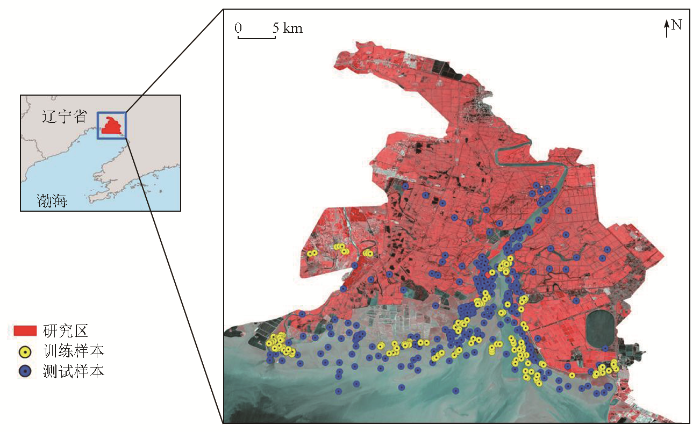
图1
研究区地理位置及样点分布
Fig.1
Location of the study area and layout of the sampling points
1.2 数据来源
结合目视解译和实地调查方式,获取样本共580个,其包含的碱蓬与非碱蓬样本数量相等。训练样本从样本库中随机选择,个数为180,剩余样本作为测试集以检验模型性能。其中,非碱蓬样本分为2组: 与碱蓬相似的地物,即滩涂、盐沼、芦苇和草本; 与碱蓬相似度较低的地物,即不透水面、养殖池和水体。
2 研究方法
2.1 分类特征集构建
辽河口盐地碱蓬于每年4—5月长出地面,其绿色特征与湿地植被如芦苇、蒲草等相似,难以利用遥感影像进行区分; 至6月,盐地碱蓬进入生长期,颜色变为浅红; 8—9月,盐地碱蓬进入花期,呈现深红色,分类特征明显; 11月后,盐地碱蓬进入枯萎阶段[1,10]。在综合考虑盐地碱蓬不同生长阶段的影像特征后,选择9月作为盐地碱蓬的最佳分类时段,并基于Google Earth Engine (GEE)平台筛选该时段内受云及其阴影影响较小的相对低潮影像,得到2017—2022年覆盖研究区的高质量遥感影像共6景(表1)。根据已选定的影像构建了包含12个影像波段、27个波段比值特征以及13个指数特征共计52个特征的特征集,具体计算公式见表2。
表1 选中的2017—2022年卫星影像
Tab.1
| 时间 | 产品类型 | 云量/% |
|---|---|---|
| 2017-09-29 | Level-1C | 0 |
| 2018-09-04 | Level-1C | 1.08 |
| 2019-09-14 | Level-2A | 0.51 |
| 2020-09-18 | Level-2A | 0.01 |
| 2021-09-23 | Level-2A | 0 |
| 2022-09-18 | Level-2A | 0 |
表2 Sentinel-2影像特征介绍
Tab.2
| 特征类型 | 特征 | |
|---|---|---|
| 光谱 特征 | B2,B3,B4,B5,B6,B7,B8,B8A,B11,B12,VV,VH | |
| 波段比 值特征 组 | B2/B4,B3/B4,B3/B8,B4/B2,B4/B3,B4/B5,B4/B8,B5/B3,B5/B4,B6/B3,B6/B5,B7/B3,B7/B4,B8/B2,B8/B3,B8/B4,B8/B5,B8/B11,B8/B12,B8A/B5,B11/B8,B11/B12,B12/B4,B12/B8,B12/B11,VV/VH,VH/VV | |
| 指数特 征组① | 归一化植被指数(normalized difference vegetation index, NDVI) | |
| 增强植被指数(enhanced vegetation index, EVI) | ||
| 植被衰减指数(plant senescence reflectance index, PSRI) | ||
| 归一化差异红色变异指数(normalized difference red edge, NDRE) | ||
| 地表水分指数(land surface water index, LSWI) | ||
| 归一化水分指数(normalized difference water index, NDWI) | ||
| 修正的归一化差异水体指数(modified normalized difference water index, mNDWI) | ||
| 植被近红外反射指数(near-infrared reflectance of vegetation, NIRv) | ||
①SWIR表示B11和B12这2个波段; RE表示B5, B6, B7, B8A这4个波段。
2.2 随机森林模型训练与最优决策规则重建
基于构建的训练样本和特征集,应用R语言的randomforest包进行随机森林模型训练。随机森林是一种集成随机构建的决策树的强分类器,其通过随机选择特征子集和样本子集构建决策树,并通过投票综合这些决策树的结果以提高分类精度[23]。本研究中,随机森林模型决策树数量设置为500,构建决策树每个结点的备选分类特征数目为7。
已训练的随机森林模型内部决策规则需要重构才能表征投票过程。考虑到最简单的决策规则的由特征、关系和阈值构成,因此可遍历随机森林模型的各决策规则,并按照特征与阈值的关系分组,将决策规则离散化为特征频数和相应特征的阈值分布。参照遗传算法,按照特征频数随机初始化种群,得到一系列特征组合及其对应的阈值区间,然后依据遗传算法求解各个特征组合对应的最优阈值。其中,遗传算法参数保持默认设置,即种群个体数目为200,最大迭代次数为100,变异率为0.01。各个特征对应阈值的最大和最小值通过获取的阈值分布估算得到。遗传算法的适应度函数采用Jaccard指数。Jaccard指数可以衡量2个集合之间相似性,公式为A∩B/A∪B,其中A和B分别表示盐地碱蓬的分类结果与参考分布[21]。Jaccard指数值为1时表示分类结果与参考分布完全相同,为0则表示分类结果与参考分布完全不同。对于得到的一系列解集,按照Jaccard指数值进行排序,优选特征数量少、准确度高的特征及其阈值作为潜在解。通过局部分类结果筛选选定的潜在解,获取经过重构的决策规则。
综上,从已训练的随机森林模型中提取决策规则识别盐地碱蓬工作流程如图2所示: ①观测最佳时相确定; ②分类特征集构建; ③随机森林模型训练; ④遍历模型内部决策规则; ⑤决策规则重构。
图2
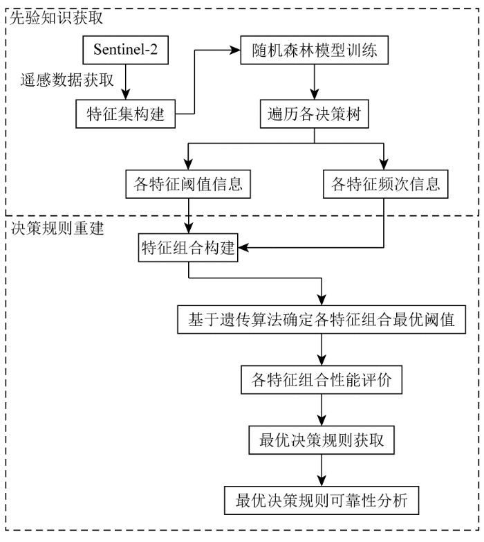
图2
从已训练随机森林模型中提取决策规则识别盐地碱蓬工作流程
Fig.2
Workflow of extracting decision rules from trained RF models to derive Suaeda Salsa map
2.3 决策规则的迁移应用
为获取研究区内不同年份的盐地碱蓬分布数据,对已构建的决策规则进行阈值优化是必要的。这是因为不同年份遥感影像成像时间不同,气候条件、卫星姿态等差异会导致同一地物的反射率发生变化。因此,在前述的遗传算法基础上,根据土地覆被类型未发生变化的样本,对决策规则阈值进行优化。在此基础上,通过目视校验方法进一步改进盐地碱蓬识别结果,提高分类结果的可用性。
2.4 精度评价
使用混淆矩阵评价盐地碱蓬识别决策规则的精度,包括总体精度 (overall accuracy,OA) 、生产者精度 (producer accuracy,PA) 和用户精度 (user accuracy,UA) 。验证样本为2019年采集,包括数目相等的碱蓬样本与非碱蓬样本共计400个,对于其余年份的验证样本,利用现有样本及高分辨率的谷歌地球影像进行采集且确保每年样点数量保持一致。各评价指标公式为:
式中: n为类别数; N为验证样本点数; pii为第 i 行和第i列中被正确分类的样本数; p+i为第i列的总和; pi+为第i行的总和。
3 结果与分析
3.1 盐地碱蓬遥感识别决策规则的构建与应用
表3 混淆矩阵与精度分析
Tab.3
| 类别 | 碱蓬 | 非碱蓬 |
|---|---|---|
| 碱蓬 | 199 | 23 |
| 非碱蓬 | 1 | 177 |
| UA/% | 89.6 | 99.4 |
| PA/% | 99.5 | 89.0 |
| OA/% | 94.0 | |
表4 不同年份对应决策规则的分类精度结果
Tab.4
| 时间 | 阈值信息 | OA/% |
|---|---|---|
| 2017-09-29 | B3/B4<0.98 & B5/B3≥1.16 | 86.0 |
| 2018-09-04 | B3/B4<1.0 & B5/B3≥1.20 | 92.5 |
| 2020-09-18 | B3/B4<0.88 & B5/B3≥1.46 | 96.8 |
| 2021-09-23 | B3/B4<0.83 & B5/B3≥1.46 | 97.3 |
| 2022-09-18 | B3/B4<0.96 & B5/B3≥1.26 | 98.5 |
图3
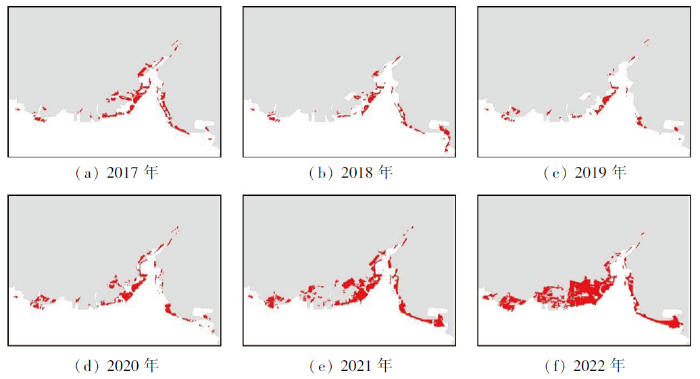
图3
2017—2022年辽河口盐地碱蓬时空变化
Fig.3
Temporal and spatial distribution changes of Suaeda Salsa in Liaohe estuary from 2017 to 2022
表5 2017—2022年辽河口盐地盐地碱蓬面积
Tab.5
| 年份 | 2017年 | 2018年 | 2019年 | 2020年 | 2021年 | 2022年 |
|---|---|---|---|---|---|---|
| 面积 | 1 154.69 | 732.43 | 658.15 | 1 380.20 | 3 048.38 | 4 221.75 |
3.2 最优决策规则的可靠性分析
图4

图4
决策规则内部各特征分类结果
Fig.4
Classification results of each elements of the decision rule
表6 SSVI提取盐地碱蓬结果的混淆矩阵
Tab.6
| 类别 | 碱蓬 | 非碱蓬 |
|---|---|---|
| 碱蓬 | 139 | 5 |
| 非碱蓬 | 61 | 195 |
| UA/% | 96.5 | 75.9 |
| PA/% | 69.5 | 97.5 |
| OA/% | 83.3 | |
表7 2017—2022年SSVI提取盐地碱蓬的阈值与精度
Tab.7
| 时间 | 阈值信息 | OA/% |
|---|---|---|
| 2017-09-20 | SSVI > 4 | 73.0 |
| 2018-09-27 | SSVI > 0.3 | 84.0 |
| 2020-09-30 | SSVI > 1 | 71.5 |
| 2021-09-01 | SSVI > 3 | 66.8 |
| 2022-09-01 | SSVI > 5 | 79.5 |
3.3 辽河口盐地碱蓬的时空变化分析
图5
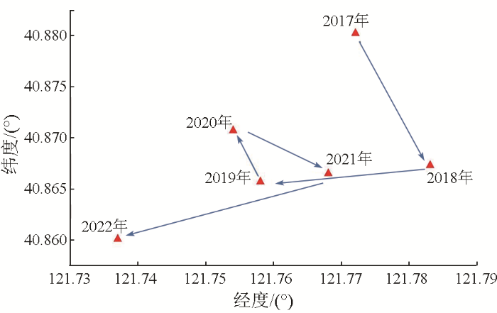
图5
2017—2022年辽河口国家自然保护区碱蓬的质心迁移情况
Fig.5
Centroids shifting of Suaeda Salsa in Liaohe estuary from 2017 to 2022
在盐地碱蓬快速增长阶段(2019—2022年),其质心首先向西北偏移,然后又折向东南,最后再向西南方向迁移。结合表4,盐地碱蓬向退养区域的扩张是导致其质心向西南迁移的主要原因,表明辽河口西岸养殖池设施的拆除为盐地碱蓬提供了更多生存空间。
3.4 盐地碱蓬、芦苇与养殖池的转化案例分析
图6

图6
辽河口东岸盐地碱蓬转化示意图
Fig.6
Schematic diagram of succession of Suaeda salsa in the east bank of Liaohe estuary
图7-1
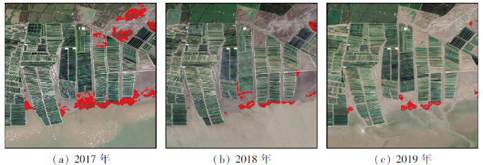
图7-1
辽河口西岸盐地碱蓬转化示意图
Fig.7
Schematic diagram of succession of Suaeda salsa in the west bank of Liaohe estuary
图7-2
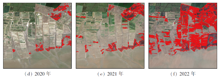
图7-2
辽河口西岸盐地碱蓬转化示意图
Fig.7-2
Schematic diagram of succession of Suaeda salsa in the west bank of Liaohe estuary
4 结论
本文以Sentinel-2影像为数据源,基于随机森林模型与遗传算法,重构了一套可自我解释的盐地碱蓬决策规则(B3/B4<0.90 & B5/B3≥1.46),后利用该分类决策规则高精度快速提取了2017—2022年辽河口盐地碱蓬分布信息,并得出以下结论:
1)本研究重构得到的盐地碱蓬决策规则对2019年辽河口国家自然保护区的盐地碱蓬OA达到94.0%,UA达到89.6%,PA达到99.5%。在2017—2019年间,该地区盐地碱蓬从1 154.69 hm2衰减至658.15 hm2,而在“退养还湿”工程实施后,盐地碱蓬向退养区域快速扩张,其面积也于2022年恢复至4 221.75 hm2。
2)相较于现有的SSVI指数,本研究重构得到的决策规则对盐地碱蓬的提取完整度更高,尤其是在缓解提取小型盐地碱蓬斑块时的漏分现象方面。
3)“退养还湿”工程的实施在辽河口国家自然保护区西部创造了适宜盐地碱蓬生长的大面积裸滩,这是该地区盐地碱蓬质心位置总体向西南方向迁移的主要原因。
4)对辽河口国家自然保护区盐地碱蓬的转化情况分析可知,盐地碱蓬可在浅滩快速生长扩张,但泥沙堆积导致的地形抬升会迫使其被芦苇演替。同时,盐地碱蓬在退养区域的快速扩张表明“退养还湿”工程成效显著。
参考文献
Areal extent,species composition,and spatial distribution of coastal saltmarshes in China
[J].
辽河口潮滩湿地景观格局空间演变的动态分析
[J].
Dynamic analysis of spatial evolution of landscape pattern in the tidal flat wetlands at Liao River Estuary
[J].
Distribution and disturbance dynamics of habitats suitable for Suaeda salsa
[J].
辽宁碱蓬根际土壤真菌多样性的季节变化及其耐盐性
[J].
Effect of season and variation in salinity on the rhizosphere fungal diversity of Suaeda liaotungensis
[J].
辽河三角洲翅碱蓬湿地不同植被覆盖度下的土壤对碳的扣留
[J].
Carbon sequestration along vegetation coverage gradient in the Suaeda salsa marsh from the Liaohe Delta
[J].
结合多模态数据的滨海湿地碱蓬叶面积指数无人机高光谱反演
[J].
UAV hyperspectral inversion of Suaeda Salsa leaf area index in coastal wetlands combined with multimodal data
[J].
湿地遥感研究进展
[J].
DOI:10.13249/j.cnki.sgs.2013.011.1406
[本文引用: 1]

湿地在维持生态平衡、保护生物多样性等方面发挥着重要作用。由于各种自然、人为因素的影响,目前越来越多的湿地转化为农业和城市用地,湿地的质量退化和数量减少引起人们广泛关注。遥感技术为湿地研究提供强有力的技术支撑。重点从遥感影像数据源、湿地分类、湿地调查3个方面论述遥感技术在湿地研究中的应用,同时指出目前湿地遥感研究中存在的不足,并展望其未来发展。
Application of remote sensing technology to wetland research
[J].
Assessing the ecosystem health of coastal wetland vegetation (Suaeda salsa) using the pressure state response model,a case of the Liao River Estuary in China
[J].
基于空谱融合与AlexNet算法的滨海湿地植被分类研究
[J].
Vegetation classification combining spatial—spectral feature fusion based on remote sensing and AlexNet algorithm in a coastal wetland
[J].
Notions of explainability and evaluation approaches for explainable artificial intelligence
[J].
Explaining recommendations:Design and evaluation
[M]//
GF-1 WFV影像的翅碱蓬植被指数构建
[J].
Construction of Suaeda salsa vegetation index based on GF-1 WFV images
[J].
An assessment of the effectiveness of a random forest classifier for land-cover classification
[J].
Toward a better understanding of coastal salt marsh mapping:A case from China using dual-temporal images
[J].
Transparent rule generator random forest (TRG-RF):An interpretable random forest
[J].
The role of waterlogging stress on the distribution of salt marsh plants in the Liao River Estuary wetland
[J].
Toward a better understanding of coastal salt marsh mapping:A case from China using dual-temporal images
[J].
Sentinel-2密集时间序列数据和Google Earth Engine的潮间带湿地快速自动分类
[J].
Rapid and automatic classification of intertidal wetlands based on intensive time series Sentinel-2 images and Google Earth Engine
[J].
Machine learning applied to diabetes dataset using Quantum versus Classical computation
[C]//2020 IEEE International Symposium on Signal Processing and Information Technology (ISSPIT).
长株潭城市群湿地景观时空动态变化及驱动力分析
[J].
Temporal and spatial dynamic changes and driving forces analysis of wetland landscape of Chang-Zhu-Tan urban agglomeration
[J].
Forecasting land-cover change effects on waterbirds in Xiamen Bay,China:Determining prospective species winners and losers
[J].
