

0 引言
在国外,人口特征和空间关系常被当作区分城区和外围乡村的重要因素。例如,爱尔兰、伊朗和瑞典等国家,将人口数量、人口密度和房屋间距等作为城镇划分标准; 荷兰将人口规模和从业结构作为确定城区范围的依据; 英国从土地利用的视角,结合人口规模和集聚程度,将具有城市特征的区域确定为城区; 日本以人口特征和通勤比例为指标来确定城区范围; 美国根据城市发展阶段,将人口和人口所在地域的空间关系特征、劳动力市场特征作为城乡划定标准[4]。
国内也有众多学者围绕城镇范围确定开展相关研究,大致可分为4类。第一类是基于人口特征和空间关系的确定方法。此类方法将人口规模、人口密度和人口分布等人口特征作为基础指标,结合公共服务设施和基础设施的“连通”条件来确定城镇范围[5
城镇范围实际可理解为城区和镇区2个概念。镇区范围确定也是国土空间规划的重要依据,而现有的研究成果多集中于城区范围划定,忽视了城乡交融带的镇区[24]。本文以“三调”数据为基础,辅以统计公报、遥感解译和POI数据,以地理信息技术(geographic information system,GIS)为支撑,探讨土地利用类型的特征和空间关系,提出一种以人为核心,科学定量化的镇区范围确定方法。在此基础上,选取福建省宁德市霞浦县作为实证研究区域来验证方法的可行性和准确性,期望为调整城镇建设用地结构、优化县及以下级国土空间规划编制等管理工作提供支撑。
1 相关概念及界定
国家统计局、国务院以及住建部发布的一系列政策文件对镇区范围的划定具有重要的指导意义[25-
2 镇区范围确定方法
2.1 镇区初始范围和实体范围确定
“三调”成果数据对地类图斑的标注存储于地类图斑图层(DLTB)中。根据DLTB属性代码和镇区初始范围定义,可提取202(建制镇)和202A(建制镇独立工业用地)的图斑,将其空间范围作为镇区初始范围。
镇区实体范围确定第一步是确定待纳入镇区实体地域范围图斑。首先根据图斑的用地类型进行分类编码(共12类),再综合考虑镇区实体定义和实际功能赋予图斑“待纳入属性”。本文根据用地是否承担镇区发展和建设功能将图斑分为3类(表1): ①将满足镇区用地类型基本特征,明确发挥镇区功能的建成区界定为镇区并纳入必选项,例如商业区、服务业区、工业区、住宅区等; ②将具备镇区居住、休闲、娱乐、生态涵养等必要功能,需要二次判断的区域界定为待选项; ③将未承担镇区基础功能的区域界定为剔除项,例如农耕地、农业经济活动地、采矿区等。
表1 图斑纳入标准
Tab.1
| 图斑用地类型 | 待纳入 项属性 | 是否纳入 实体范围 |
|---|---|---|
| 商业服务业(05),工业(0601),城市住宅(0701)和公共管理与公共服务(08),除管道运输外的交通运输 (10) | 必选项 | 做连接条件判断 |
| 湿地(00),林地(03),草地(04),农村宅基地(0702),特殊用地(09),管道运输(1009),水域及水利设施(11) | 候选项 | 待作支撑发展功能和连接条件判断 |
| 耕地(01),种植园(02),采矿(0602)和其他土地(12) | 剔除项 | 否 |
表2 镇区功能性界定标准
Tab.2
| 类型 | 具备支撑发展功能性条件 |
|---|---|
| 湿地 | 具备公园功能或被镇区三面包围 |
| 林地 | 承担镇区生态涵养功能或被镇区三面包围 |
| 草地 | 具备休闲功能或被镇区三面包围 |
| 农村宅基地 | 具备镇区居住功能或被镇区三面包围 |
| 特殊用地 | 根据情况具体判断 |
| 管道运输 | 承担镇区居民生活必备物运输功能或被镇区三面包围 |
| 水域及水利设施 | 具备公园或承担镇区生态涵养功能或被镇区三面包围 |
表3 阻隔要素及连接条件
Tab.3
| 阻隔要素 | 连接条件 |
|---|---|
| 河流 | 有桥梁、轮渡、隧道、涵洞,且可供行车辆行人顺利通行 |
| 铁路 | 有铁路道口、桥梁、隧道,且可供车辆行人顺利通行 |
| 高速公路 | 有桥梁、隧道,且可供车辆行人顺利通行 |
第三步是迭代更新。设置符合研究区实际情况的缓冲分析阈值和迭代次数,在当前镇区实体地域范围(第1次迭代完成后)的基础上做迭代更新(重复第一步和第二步),直至待纳入图斑中无符合条件的新图斑出现。迭代次数一般为5次,局部地区如有需要可适当增加。考虑到用地属性特征和支撑镇区发展功能性,部分图斑若是参与迭代可能会误纳入距离镇区较远或未承担镇区相关服务功能的图斑,所以线状特征图斑(如道路和沟渠)、镇区初始范围内空洞图斑与湿地、草地和林地图斑均赋予“剔除项”属性,不参与第2次及以后的迭代。
第四步是对特殊用地情况另作判断以及边界核查,如表4所示。
表4 特殊情况纳入及边界核查
Tab.4
| 图斑所属区域 | 是否纳入 实体范围 |
|---|---|
| 各级国家、省级开发区、工业园区、服务区已建成区 | 是 |
| 机场、火车站、港口等重要交通设施 | 是 |
| 其他不可替代的支撑镇区发展功能区域 | 是 |
| 划定县镇的行政范围外 | 否 |
| 生态保护红线内 | 否 |
| 永久基本农田界线内 | 否 |
| 超出镇区实体范围边界最外层居(村)委员会所辖区 | 否 |
| 独立且小的图斑 | 否 |
2.2 镇区范围确定
本文镇区范围确定的划定准则是镇区实体地域范围占镇区最小统计单元(居(村)委员会所辖区)比例。居(村)委员会所辖区是否纳入镇区范围划定准则为: 比例≥50%,纳入; 比例<20%,不纳入; 20%≤比例<50%,做镇区设施服务支撑功能判断,根据判断结果再确定是否纳入镇区范围。
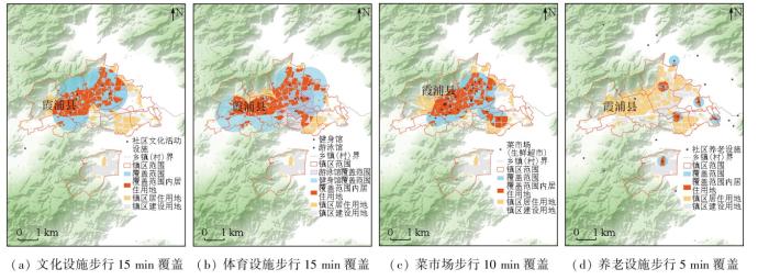
随着城镇建设结构优化和居民生活水平的提高,人们越来越看重城镇基础设施和公共服务设施的水平,城镇开发建设模式也逐渐从增量建设向提质增效转变。镇区范围划定应以人为核心,充分考虑居民对文化设施、教育设施和卫生设施等公共服务设施的功能性和质量需求,为实现镇区可持续发展提供有力支撑。
表5 设施功能范围
Tab.5
| 设施类型 | 设施种类 | 设施项目 | 服务功能覆盖标准 |
|---|---|---|---|
| 市政公 用设施 | 供电 | 变电站、电厂 | 全覆盖区域 |
| 供水排水 | 水厂、污水处理厂 | 全覆盖区域 | |
| 道路交通 | 公共交通站点 | 全覆盖区域 | |
| 消防 | 消防站、消防大队 | 3 km范围覆盖区域 | |
| 环境卫生 | 垃圾处理厂、垃圾转运站 | 全覆盖区域 | |
| 公共服 务设施 | 文化 | 各类活动中心、展览馆 | 1 km范围覆盖区域 |
| 教育 | 幼儿园、小学、中学 | 幼儿园: 300 m; 小学: 500 m; 中学: 1 km | |
| 卫生 | 卫生服务设施、各级 医院 | 卫生服务站: 300 m; 卫生服务中心: 1 km; 等级医院: 15 km; 市区级医院: 2 km |
3 霞浦县镇区范围确定实践
3.1 研究区概况及数据源
3.1.1 研究区概况
霞浦县隶属福建省宁德市,地处福建东北部沿海,三面临海、一面依山,地势由西北向东南呈三级阶梯状下降,构成半岛型区域。全县陆地面积1 716 km2,海域面积29 592.6 km2,海岸线长505 km,大小岛屿400多个。霞浦县拥有绵长的海岸线以及众多岛屿和港湾,独具地理特色,其境内自然资源要素齐全、种类丰富,地形地貌多变,是镇区范围确定方法研究的理想试验区。2020年5月,霞浦县入选县城新型城镇化建设示范,是福建省统筹城乡空间资源配置,开展“多规合一”试点工作的试点县城之一,有较好的数据基础,可用于镇区范围确定方法实例验证。
3.1.2 数据源及预处理
本文在镇区范围确定过程中使用到的霞浦县遥感数据来源于高分二号卫星最新影像,空间分辨率可达0.8 m。该影像空间信息丰富且可清晰辨别地物边界,可确保镇区范围提取的精确性。基础公用和公共服务设施数据来源于遥感数据的目视解译、霞浦县政府部门空间规划资料和高德POI大数据。
本文利用ArcGIS软件对统计数据和POI数据进行矢量化,并与“三调”数据统一投影和坐标系统: 2000国家大地坐标系、1985国家高程基准、高斯—克吕格投影3°分带(CGCS2000_3_Degree_GK_Zone_40)。
3.2 基于GIS的镇区范围确定
本文利用GIS技术,以“三调”数据、遥感影像、国土空间规划资料和POI数据为数据基础,综合考虑地类类别、空间连通条件、特殊用地情况、基础设施和公共服务设施等城市功能条件,提出一种非设市县镇区确定方法。本方法总体可分为3步: 镇区初始范围确定、镇区实体范围确定和镇区范围确定(图1)。
图1
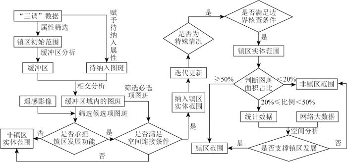
图1
基于GIS的镇区确定方法技术流程
Fig.1
Technical flow chart of town determination method based on GIS
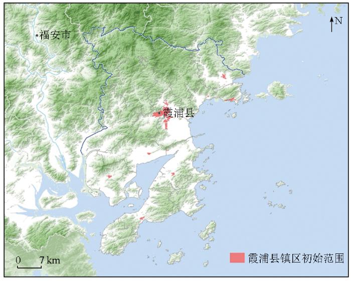
依据霞浦县“三调”更新的成果数据,从中选取霞浦县“城市范围”(城镇村属性代码为202及202A)数据,作为镇区实体的初始范围(图2)。镇区初始范围共有图斑1 174个,面积为13.95 km2。
图2
在霞浦县镇区初始范围的基础上,利用GIS技术根据界定标准为图斑赋予“纳入项”属性,将“剔除项”属性图斑删除,得到待纳入图斑; 其次对“镇区初始范围”作缓冲区分析,缓冲阈值为100 m,得到“缓冲区”,并与待纳入图斑作相交分析,得到距离镇区初始范围100 m以内的待纳入图斑; 然后根据图斑属性,对“必选项”图斑做连接条件判断,符合条件的图斑与“镇区初始范围”做合并操作,得到“镇区实体地域范围”; 最后对“候选项”属性图斑做功能性和连接条件判断,符合条件的,纳入“实体地域”图层。迭代次数为5次,第5次迭代新增图斑个数为0,表明迭代自然终止。迭代共纳入镇区实体范围的图斑个数为238个,面积为4.31 km2。将霞浦县经济开发区建成部分、霞浦县火车站等承担必要城镇功能的地类图斑纳入实体地域范围,核查镇区内与生态红线、基本农田相交和最外层居(村)委员会所辖区等边界范围,得到霞浦县镇区实体地域范围(图3),实体地域地类图斑见表6,总面积为15.16 km2。
图3
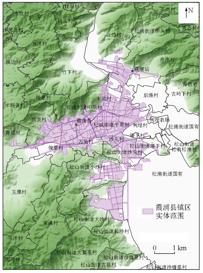
表6 镇区实体地域范围图斑统计表
Tab.6
| 序号 | 地类名称 | 图斑 数量 | 面积/m2 | 占比/% |
|---|---|---|---|---|
| 1 | 城镇住宅用地 | 171 | 555.18 | 36.62 |
| 2 | 工业用地 | 108 | 238.35 | 15.72 |
| 3 | 公路用地 | 62 | 183.61 | 12.11 |
| 4 | 城镇村道路用地 | 204 | 102.99 | 6.79 |
| 5 | 科教文卫用地 | 93 | 88.37 | 5.83 |
| 6 | 公园与绿地 | 34 | 79.22 | 5.23 |
| 7 | 商业服务业设施用地 | 139 | 69.82 | 4.60 |
| 8 | 农村宅基地 | 26 | 43.28 | 2.86 |
| 9 | 河流水面 | 45 | 30.30 | 2.00 |
| 10 | 铁路用地 | 3 | 29.13 | 1.92 |
| 11 | 其他草地 | 15 | 20.96 | 1.38 |
| 12 | 机关团体新闻出版用地 | 53 | 20.72 | 1.37 |
| 13 | 交通服务场站用地 | 27 | 16.53 | 1.09 |
| 14 | 特殊用地 | 30 | 10.45 | 0.69 |
| 15 | 物流仓储用地 | 19 | 7.38 | 0.49 |
| 16 | 公用设施用地 | 15 | 6.49 | 0.43 |
| 17 | 其他林地 | 15 | 5.90 | 0.39 |
| 18 | 乔木林地 | 5 | 2.50 | 0.16 |
| 19 | 水工建筑用地 | 7 | 1.78 | 0.12 |
| 20 | 竹林地 | 2 | 1.10 | 0.07 |
| 21 | 灌木林地 | 3 | 0.87 | 0.06 |
| 22 | 沟渠 | 2 | 0.51 | 0.03 |
| 23 | 坑塘水面 | 2 | 0.47 | 0.03 |
| 24 | 设施农用地 | 1 | 0.09 | 0.01 |
| 合计 | 1 081 | 1 516.00 | 100.00 | |
表7 镇区实体地域范围面积占比详情表
Tab.7
| 序号 | 居委会名称 | 面积占比 | 是否纳入 | 范围属性 | |
|---|---|---|---|---|---|
| 1 | 松港街道中乘村1 | 0.99 | 纳入镇区范围 | 镇区范围 | |
| 2 | 沙头村 | 0.85 | 纳入镇区范围 | 镇区范围 | |
| 3 | 万贤村 | 0.68 | 纳入镇区范围 | 镇区范围 | |
| 4 | 东关村 | 0.51 | 纳入镇区范围 | 镇区范围 | |
| 5 | 松山街道沙头村 | 0.51 | 纳入镇区范围 | 镇区范围 | |
| 6 | 俊星村 | 0.44 | 根据设施服务支撑功能判断 | 待判断范围 | |
| 7 | 松山街道大沙村 | 0.32 | 根据设施服务支撑功能判断 | 待判断范围 | |
| 8 | 利埕村 | 0.32 | 根据设施服务支撑功能判断 | 待判断范围 | |
| 9 | 西关村 | 0.29 | 根据设施服务支撑功能判断 | 待判断范围 | |
| 10 | 松城街道中乘村2 | 0.28 | 根据设施服务支撑功能判断 | 待判断范围 | |
| 11 | 松山街道塔下村 | 0.27 | 根据设施服务支撑功能判断 | 待判断范围 | |
| 12 | 其他 | <20 | 不纳入镇区范围 | 非镇区范围 | |
图4
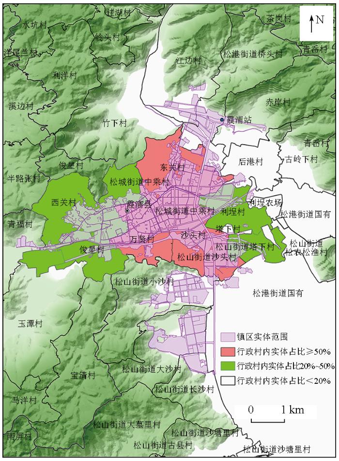
图5
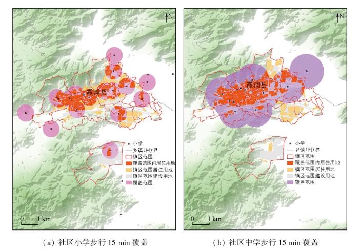
图6
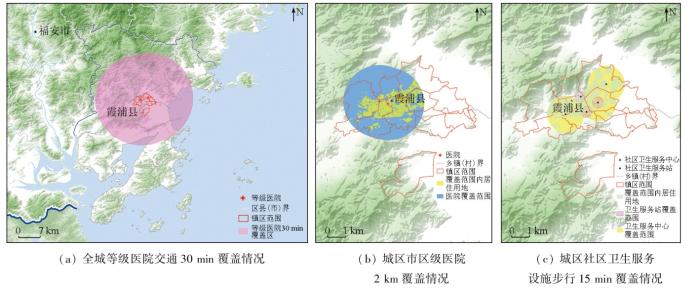
图7
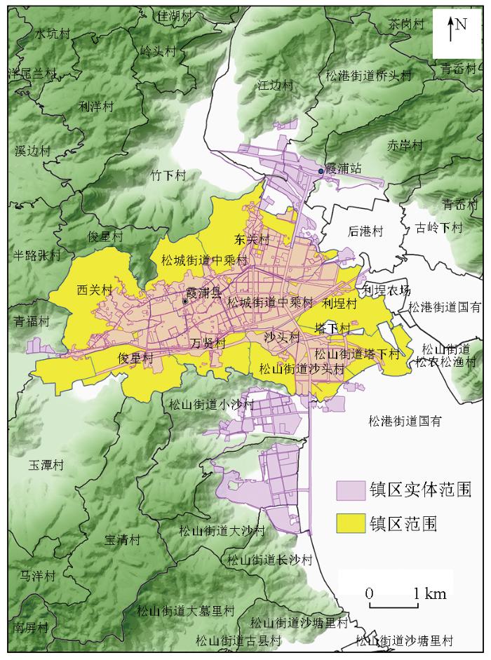
综合考虑镇区居住功能、城镇设施服务支撑功能和霞浦县实际资源分别情况,将西关村、中乘村、万贤村等9个居(村)民委员会所辖区纳入镇区范围,霞浦县总镇区范围如图8所示,镇区面积为19.45 km2。
图8
4 讨论与分析
4.1 结果分析
本文以福建省宁德市霞浦县为案例,对镇区范围确定方法和技术流程进行检验,划定结果基本符合霞浦县实际发展情况。实例检验可知,霞浦县现状建设用地高度集中在镇区,呈现“强中心”的城乡建设发展模式。镇区实体范围内城镇住宅用地和工业用地占比最高,共占比52.34%; 交通用地总占比21.92%; 科教文卫、商业服务业设施和机关团体新闻出版用地共占比11.8%。在空间配置上,霞浦县有局部开发建设高密化的特征,镇区内市政公用设施和公共服务设施相对较好,但也存在更新或升级的需求; 城镇边缘及周边区域设施配套相对不足,医疗卫生设施不充足,文化设施较为短缺,教育设施分布不均衡,缺乏优质科教文卫资源,且养老设施建设仍待改善; 受地形和土地资源分布不平衡的制约,全域产业集群发展水平较低; 此外,该县的火车站和工业园区用地虽被纳入镇区实体范围,但因基础和服务设施建设欠缺,其所在的居(村)委员会所辖区未被划定为镇区范围,此类情况可能会导致该区域产业带动能力弱,发生人口外流现象。若想培育工业园区所在的南部滨海区域成为新的城市中心区和服务集聚区,需加快道路交通、安全保障等市政设施建设,合理配置商贸、文化、教育、医疗、养老等服务设施。总体上,霞浦县自然资源丰富,生态底线管控较好,森林和草地覆盖率较高,可承担镇区日常休闲、生态涵养的用地占镇区实体面积的9.32%,但特色资源转换效率低,亟待实现资源价值转化。接下来,可对标“生态型工贸旅游滨海城市”的发展定位,不断完善国土空间规划的编制和实施,加快各类设施提档升级和覆盖延伸。
4.2 阈值验证
镇区实体范围确定过程中,本文设定缓冲阈值为100 m,对带纳入地类图斑进行了5次迭代。为验证缓冲阈值和迭代次数的合理性,分别选取50 m,100 m和150 m作为缓冲阈值,对霞浦县初始范围依次进行5次或10次迭代。试验发现缓冲阈值为50 m时,迭代产生的“带纳入图斑”中可纳入实体的“必选项”图斑较少,需要更多的迭代次数才能达到和缓冲阈值为100 m相似的试验结果,较为费时费力。同时部分地区出现了因阈值设置较小,导致迭代自然终止的情况。缓冲阈值设置为150 m时,迭代产生的“带纳入图斑”中可纳入实体的“候选项”和“剔除项”图斑增多,且至第6次迭代开始,有大量“林地”和部分县镇的行政范围外的图斑需要剔除。将3次试验结果与霞浦县发展现状、开发边界以及资源分布情况的数据进行综合比对发现,选择缓冲阈值为100 m,迭代次数为5次产生的实体范围可较为真实、合理地反映出霞浦县发展建设水平。
镇区实体范围确定中的缓冲区阈值范围还需结合城镇自身的开发和规划现状进行设定,根据实例进行阈值验证。为避免过度迭代,而将距离过远的“候选项”图斑纳入实体范围,建议迭代次数不超过5次,对确需要增加迭代次数的局部地区,可结合该区域的实际情况调整缓冲区阈值范围和迭代次数,但需遵循镇区实体范围迭代标准和边界核查标准。
4.3 地理空间与统计范围
本文根据镇区实体地域范围占镇区最小统计单元(居(村)委员会所辖区)比例来确定镇区范围,比例小于20%的居(村)委员会所辖区不纳入镇区范围。但在实践过程中发现,对于临山、海、湖地区的县镇,因受地理环境的限制,其镇区可建成的空间范围占最小统计范围的比例小于20%,但该居(村)民委员会所辖区确在镇区发展承担重要作用。此类情况需充分考虑市政公用设施和公共服务设施服务覆盖范围,对虽受地理空间位置影响但确有能力承担镇区功能的居(村)委员会所辖区,结合当地自然人文资源和政府规划发展布局进一步讨论是否纳入镇区范围。
4.4 多源数据相结合
“三调”数据可提供详细和精准的土地利用现状,且数据库保持定期更新,可为国土空间规划的实施提供时空对比基底。然而土地调查数据由国家定期展开,更新频率不足,时效性尚无法支撑政府每年一次的国土空间规划城市体检评估工作。遥感影像和POI等大数据具有范围广、更新快、精度高等特点,已成为城镇范围确定的重要数据源,但单纯基于遥感和POI数据的城区边界提取方法存在标准不统一、计算复杂、自动化程度低等问题,难以大范围推广使用。因遥感影像和POI等大数据具有丰富的地理属性和空间特征,通过坐标系转化能够确保其与土地调查数据完美结合。融合土地调查数据和大数据的镇区范围确定方法,可更加客观地反映城镇空间发展变化,更好地服务于城镇国土空间规划动态优化调整和城镇体检评估工作。
5 结论与展望
县城在我国城镇化发展中扮演重要角色,科学确定“镇区范围”是制定城乡政策、统计城乡发展数据和提升城乡建设管理的基础。本文以国土调查数据为基础,辅以高清遥感影像和POI数据,利用GIS技术,探索出一种适用于非设市镇的镇区确定方法,并以福建省宁德市霞浦县为实例,验证了该理论和方法的科学性和可行性。与其他城镇范围确定方法相比,本文的技术方法将定性和定量相结合,规范了统计口径,解决了基础数据不统一、缺乏可比性的问题,具有较强的可操作性和易推广性。因国土调查数据能够定期更新,该方法还可满足“镇区范围”更新需求,且可实现镇区发展变化的时空对比,为城镇发展规划成效提供可靠的分析依据。
1)基于“三调”数据,辅以政府统计数据、遥感和POI大数据,建立镇区范围确定方法流程,提出以人为核心、多源数据融合的镇区范围确定方法,可为进一步完善《镇区范围确定规程》提供新思路。
2)以霞浦县为例,采用本研究提出的方法划定霞浦县镇区范围,试验证明了该方法可有效应用在国土空间上,区分乡镇,进一步支撑经济、人口、城镇化等指标统计,指导并服务国土空间规划监督实施工作。
本文的技术流程展现了较强的科学理论性和高效性,可为地方政府实施国土空间规划、统一经济社会指标统计口径提供科学依据。但本研究尚存在一些不足之处:
1)本文实例验证单一,未考虑不同镇区功能性的差异化。后续研究应选取不同省市、不同地理空间位置、不同发展规模,具有代表性的建制镇进行实践研究,分类总结各类特殊情况,不断完善技术路线。
2)从实践看,依据本文技术流程得到镇区范围结果,与地方政府预期规划存在些许出入。主要原因是镇区现有的市政公用服务设施数据较难收集,例如小型垃圾处理点数据,且设施服务范围覆盖不规则,后续可结合手机信令、夜间灯光和人口密度数据,进一步探讨多源数据和多要素综合的镇区范围确定方法。
致谢
感谢宁德市自然资源局、霞浦县自然资源局提供“国土空间规划城市体检”项目工作并协调提供部分基础资料,中国地质调查局南京地质调查中心吴佳瑜、张艺武、张景、萧声隽、孙彦玮协助数据处理。
参考文献
中国城市化的几个现实问题:空间扩张、人口收缩、低密度人类活动与城市范围界定
[J].
Several emerging issues of China’s urbanization:Spatial expansion,population shrinkage,low-density human activities and city boundary delimitation
[J].
中国城市行政地域与实体地域的空间差异及优化整合
[J].
DOI:10.11821/dlyj020180881
[本文引用: 1]

中国的城市界定与行政区划紧密关联。根据2010年人口普查数据,系统分析不同尺度城市行政地域与城市实体地域的界定及其空间差异。主要结论:① 按照直辖市或地级市、设区的市和不设区的市、设街道的市和不设街道的市的层级,城市行政地域范围依次收缩,但是都大于城市实体地域范围。按照实体地域界定,2010年中国城市人口仅占30.18%。② 城市实体地域更能客观地反映城市位序规模的分布状态,而按照城市行政地域会导致规模或排序偏差。③ 未来在行政区划调整时,着重考虑撤县设市、增设地级市、确立乡级行政区划调整标准等,在建立城市实体地域时,可从独立市辖区、县城、特大镇等方面优化,并加强统计信息公开。
City administrative area and physical area in China:Spatial differences and integration strategies
[J].
美国城市地区划定方法及其演变对我国的启示
[J].
Standards,methods and evolution of US urban area delineation:Fine delineation reflecting physical territory concept
[J].
建立中国城市的实体地域概念
[J].
DOI:10.11821/xb199504001
[本文引用: 1]
本文总结了我国在城市的行政地域与景观地域严重背离的情况下,继续使用行政地域区分城乡的种种弊端,认为解决这一问题的关键在于建立适合中国特点又具有国际可比性的城市实体地域概念,以此作为城乡划分及统计的地域基础,文章提出以下限人口规模、非农化水平和人口密度三个指标定义城市实体地域,并在大量实证研究的基础上,通过对中国城市空间形态的分类,提出了一套完整的划分实体地域的方法和工作程序。
Toward establishing the concept of physical urban area in China
[J].
DOI:10.11821/xb199504001
[本文引用: 1]
It is generally agreed that human settlements are classified either as urban places or as rural places,In urban studies,one has to deal with the relerant materials in the right way so as to reflect the reality of urban area.Urban areas may be conceived as administrative, functional and physical entities. This paper make a detailed analysis on the various drawbacks of the continued use of adiministrative area in the division of urban and rural area in spite of the serious discrepancies between urban administrative boundaries and the real’ urban space in China, Almost the administrative area of all cities and towns are much larger than the urban built-up area. As a result, vast rural areas and large agricultural population were included in the urban count. Here lies the principal difference with western countries. Obviously, it is difficult if not impossible for us to solve the contradiction by reducing the adiministrative area of a city or town. The authors believe that to solve this problem, it is essential to establish the concept of physical urban area with both adaptability to Chinese conditions and international comparability and make it the basis of urban-rural division and statistics.It is proposed that physical urban area in China can be delimitated in terms of three criteria,prescribed minimum population scale, degree of nonagricuturalization and population density, and the names of citied area or townized area can be given as the counterpart of urbanized area in the United States.The administrative area of a city or town in China consists of two parts: urban district and suburban area. The combination of the two parts is very conplex. For this reason, the key to put our scheme into effect is the classification of types according to the different relations between the two parts.Based on extensive research, the authors find that three factors bring about twelve types. AIa and AIb of them are the most basic types,All these types have their own quantitative standards.After understanding these types, the delineation of the physical urban areas become fairly easy according to the flow diagram(Fig.1).Eleven samples, except one type which is not find,are cited in this paper (Fig.2).
城乡地域划分和城镇人口核定研究——以常熟市为例
[J].
Study on urban-rural area division and urban population counting——The case of Changshu city
[J].
上海市城乡实体地域的划分
[J].
Urban and rural area division:Taking Shanghai as an example
[J].As a basis of counting urban population, the correct urban-rural division is an important component in collecting, classifying and analysing socio-economic statistics. Research on urban and rural area division method has the vital significance both in theory and practice. Using Shanghai 2000 aerial remote sensing photographs and the Population Geographical Information System, this paper makes an experimental division of urban and rural areas. Detailed division method discussion has been made for three kinds of urbanized area, i.e., Shanghai city proper, the suburban Qingpu District and outer suburban Zhangyan town of Jinshan District, for the purpose of simulating regional division of the metropolitan, urban and town areas separately. It firstly introduces the basic division processes of the three types of urban and rural areas. Then it conducts a comparative study on different precision results of each type of the areas. Finally the authors discuss the three types of urbanized area divisions for metropolises, medium- and small-sized cities as well as towns in terms of precision to be reached in the near- and long-term respectively. Appropriate precision and simple operation is the focus of this research, which aims at promoting the urbanized area division work in a wide range.
城市建成区面积统计口径亟待统一——以杭州中心城区为例
[J].
Establishing a uniform standard for calculation of urban built-up area—with Hangzhou central city zone as an example
[J].
城镇建成区概念与界定方法体系研究——以浙江德清市武康镇为例
[J].
The concept and definition of urban built-up area:A case study of Wukang town in Zhejiang Province
[J].
城市建成区界定方法研究——以武汉市为例
[J].
Study on the definition method of urban built-up area—Taking Wuhan as an example
[J].
城区边界遥感提取研究进展
[J].
Review on remote sensing extraction of urban boundary
[J].
一种新的高分辨率遥感影像城区提取方法
[J].
Automatic urban area extraction using a Gabor filter and high-resolution remote sensing imagery
[J].
基于多元数据的大都市区范围划定方法研究——以武汉为例
[J].
Study on the method of metropolitan area delimitation based on multi-data:A case study of Wuhan
[J].
Urban boundary extraction and urban sprawl measurement using high-resolution remote sensing images:A case study of China’s provincial capital
[C]//
Integrating bottom-up classification and top-down feedback for improving urban land-cover and functional-zone mapping
[J].
西安市城市边缘区空间识别与边界划分
[J].
DOI:10.3724/SP.J.1047.2017.01327
城市边缘区研究的首要任务是对城市边缘区进行空间识别和边界划分。针对现有研究存在的指标选取过于单一或繁杂、水陆分离导致划分间断等问题,利用西安市SPOT-5、Landsat TM遥感影像和社会统计数据,分别从物理、景观、人口3个视角出发,选定不透水面盖度与景观絮乱度作为主要判别指标,人口密度作为辅助指标,构建城市边缘区识别指标体系。运用信息熵法和突变检测法,量化并可视化西安市城市边缘区的空间范围。结果表明:① 所选取指标沿着城乡梯度表现出独特的空间信息,根据指标的城乡空间异质性特征可以识别出城市边缘区的空间范围,且方法更科学,界定结果更精确。② 西安市呈现出明显的城市核心区、城市边缘区、农村腹地的圈层结构特征。道路牵引与政策调控对城市边缘区的空间分布有重要影响。本研究可为城市边缘区其他相关研究提供科学参考和依据。
Spatial recognition and boundary region division of urban fringe area in Xi’an City
[J].
多源遥感数据的城市边界提取及动态变化研究
[J].
Urban boundary extraction and dynamic change based on multisource remote sensing data
[J].
上海都市区边界划分——基于手机信令数据的探索
[J].都市区是中心城市及其主要影响范围,在区域经济发展中有重要的引领作用。国外都市区范围根据中心城市与外围地区的通勤联系划分,本质上是与中心城市具有密切经济联系的统一劳动市场区。国内由于统计数据的缺乏,通过通勤联系划分都市区的相关研究难以开展,且划分结果在内涵上与国外都市区差异较大。移动电话是目前普及率最高的移动通讯终端设备,其包含的地理位置标签可反映用户的职住地信息。利用上海移动2014年上半年某两周2G手机信令数据,识别用户的居住地和工作地,参照国外标准,根据中心与外围地区的通勤联系划分上海市都市区。在通勤联系的基础上,尝试采用消费联系作为都市区划分的辅助标准,并对划分结果进行了调整。结果表明:① 基于通勤联系的上海都市区主要包括中心城周边地区、松江新城及外围大型工业区,基于消费联系调整的上海都市区包括中心城周边地区、松江、嘉定、青浦等新城及浦东惠南地区、长兴岛,整体上呈现东西略长、南北略窄的形态;② 通勤联系和消费联系可以相互结合划分中国的都市区边界,通勤联系作为主要指标,消费联系作为辅助指标;③ 上海与国外城市都市区差异较大,国外都市区范围扩展极广,上海都市区范围未超过行政边界,局限在在中心城周围相对较小的范围内。
Delimiting the Shanghai metropolitan area using mobile phone data
[J].A metropolitan area, which plays a dominant role in the regional economic development, is defined as a composite of a densely populated urban core and its surrounding interlocking territories. It is essentially a unified labor market that is delimited by the commute flows between a principal city and the peripheral area in most of foreign countries. However, due to the absence of commuting census data in China, it is either too difficult to conduct delimitations based on the commuting linkage or the results could be completely different from those in foreign countries. We based our delimitation on commuting flows identified from mobile phone data, which records the users' spatio-temporal information while they communicate with the network via towers. First, we inferred the user's residence and workplace using two weeks of China Mobile's 2G mobile signaling data in 2014. Then, we delimited the boundary of Shanghai metropolitan area according to the foreign standards. Additionally, we proposed to utilize the recreational activity, also inferred from the mobile phone data, as an auxiliary standard to adjust the boundary. The conclusions can be drawn as follows: (1) In terms of commuting flows, the Shanghai metropolitan area covers the surrounding area of the central city, the Songjiang new town and the large industrial zones in the urban fringe, while in terms of recreational activity, it includes the surrounding area of the central city, the new towns of Songjiang, Jiading, Qingpu, the Huinan area, and the Changxing Island. Morphologically, the Shanghai metropolitan area is slightly longer in the east-west direction and narrower in the north-south direction. (2) The commuting and recreational connections can be combined to delimit a metropolitan area in China, while the former could be the primary indicator with the latter as the auxiliary. (3) Huge difference exists between the metropolitan area of Shanghai and the foreign ones. The foreign metropolitan areas usually have more expanded ranges covering surrounding jurisdictional zones, while the Shanghai metropolitan area mainly grows within its administrative boundary and is confined to a relatively small area around the central city.
基于POI数据的城市边界变化提取研究——以山西运城市城区为例
[J].
Study on urban boundary identification based on POI:A case study of Yuncheng City in Shanxi
[J].
基于电子地图兴趣点的城市建成区边界识别方法
[J].
DOI:10.11821/dlxb201606003
[本文引用: 2]
城市建成区边界是认识和研究城市的重要基础性信息,也是落实城市功能空间布局、实施界限管控的前提。但是,以往通过夜间灯光的强度、土地覆被或建筑覆盖率等信息获取城市空间范围的方法,由于受到数据精度和尺度限制,对城市社会经济活动的解释性不强,因而存在较大局限性。电子地图兴趣点(POI)作为城市空间分析的基础数据之一,直观且有效地反映了各类城市要素的集聚状况。本文基于POI与城市空间结构和城市要素空间分布的关联性,提出了一种新的通过POI密度分布来判别城市建成区边界的技术方法。为此,开发了Densi-Graph分析方法,用来分析POI密度等值线的变化趋势,在此基础上对城乡过渡地带的阈值识别的方法进行了理论分析,并讨论了单中心圆结构、双中心“鱼眼型”结构、双中心“子母型”结构等各类城市POI密度等值线的生长规律,证明了Densi-Graph分析方法的适用性。较之以往的城市建成区边界识别方法,这种方法的基础数据更加直观可信,分析结果也更加客观。运用这种方法,本文对全国地级以上城市的建成区边界进行了实证分析,探索了城市建成区边界的阈值及其与城市人口规模、城市所在区域之间的关系。
A novel method for identifying the boundary of urban built-up areas with POI data
[J].
DOI:10.11821/dlxb201606003
[本文引用: 2]
The boundary of urban built-up areas provides foundational information for urban studies and meets the requirements for urban pattern and urban spatial structure research. However, commonly used methods for identifying the boundary of urban built-up areas such as using remote sensing data of night-light and land use, cadastral data, and building coverage data, are limited in accuracy. To remedy this, this paper proposes to use POI (Point of Interest) data obtained from web maps, assuming that it well reflects the agglomeration of urban activities at higher precision. Based on the underlying connection between POI and the spatial distribution of urban activities, a new method called 'Densi-Graph' is proposed to identify the actual boundary of urban built-up areas with the contour map of the kernel density of POI, where the threshold value for the contour lines to make significant change from densely to loosely placed is picked, giving the boundary of urban and rural areas. Different contour structures for mono-centric, poly-centric and linear cities are discussed, whereby the Densi-Graph method using POI data is validated. The method is also used to study the boundaries of urban built-up areas in China's prefecture level cities. The relationships between the Density-Graph thresholds and the population and location of different cities are discussed. This study advances previous studies in presenting more reliable and objective data on the boundary of urban built-up areas.
城区范围空间划定方法研究
[J].
Spatial delineation methods of urban areas
[J].
国土空间规划中城区范围划定方法、条件及流程初探——以江西省景德镇市为例
[J].
A preliminary study on method,condition and procedure of urban area identification under the background of territorial development planning:Taking Jingdezhen of Jiangxi Province as an example
[J].
新时期新规划体系下的镇区范围识别研究——以晋江市安海镇为例
[C]//
Research on the identification of town area scope under the new planning system in the new era——taking Anhai Town of Jinjiang City as an example
[C]//
统计上划分城乡的规定
[EB/OL]. https://www.stats.gov.cn/sj/tjbz/gjtjbz/202302/t20230213_1902742.html.
Provisions for the statistical division of urban and rural areas
[EB/OL]. https://www.stats.gov.cn/sj/tjbz/gjtjbz/202302/t20230213_1902742.html.
城市(县城)和村镇建设统计调查制度
[EB/OL]. https://www.stats.gov.cn/fw/bmdcxmsp/bmzd/202302/t20230215_1907097.html.
Urban (county) and rural areas construction statistical survey system
[EB/OL]. https://www.stats.gov.cn/fw/bmdcxmsp/bmzd/202302/t20230215_1907097.html.
国务院关于调整城市规模划分标准的通知
[EB/OL]. http://www.gov.cn/zhengce/content/2014-11/20/content_9225.htm.
Notice of the State Council on readjustment of the standards for the division of urban dimensions
[EB/OL]. http://www.gov.cn/zhengce/content/2014-11/20/content_9225.htm.
东南沿海火山岩区城镇建设适宜性评价与实践——以福建省宁德市为例
[J].
Evaluation and practice of urban construction suitability in coastal volcanic areas of southeast China:A case study of Ningde City,Fujian Province
[J].
双评价理论探索与福建实践
[J].
Exploration on dual evaluation theory and the practice in Fujian Province
[J].
国务院第三次全国国土调查领导小组办公室关于印发《第三次全国国土调查实施方案》的通知
[EB/OL]. http://gi.mnr.gov.cn/201811/t20181120_2367135.html.
Notice of the office of the third national land survey on the issuance of the implementation plan for the third national land survey
[EB/OL]. http://gi.mnr.gov.cn/201811/t20181120_2367135.html.
