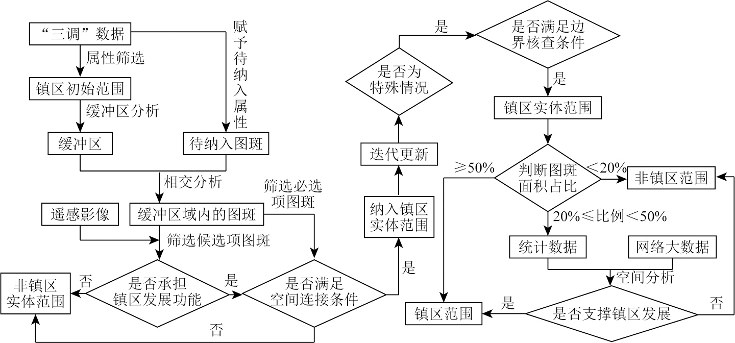
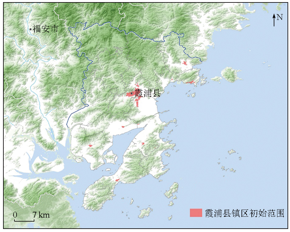
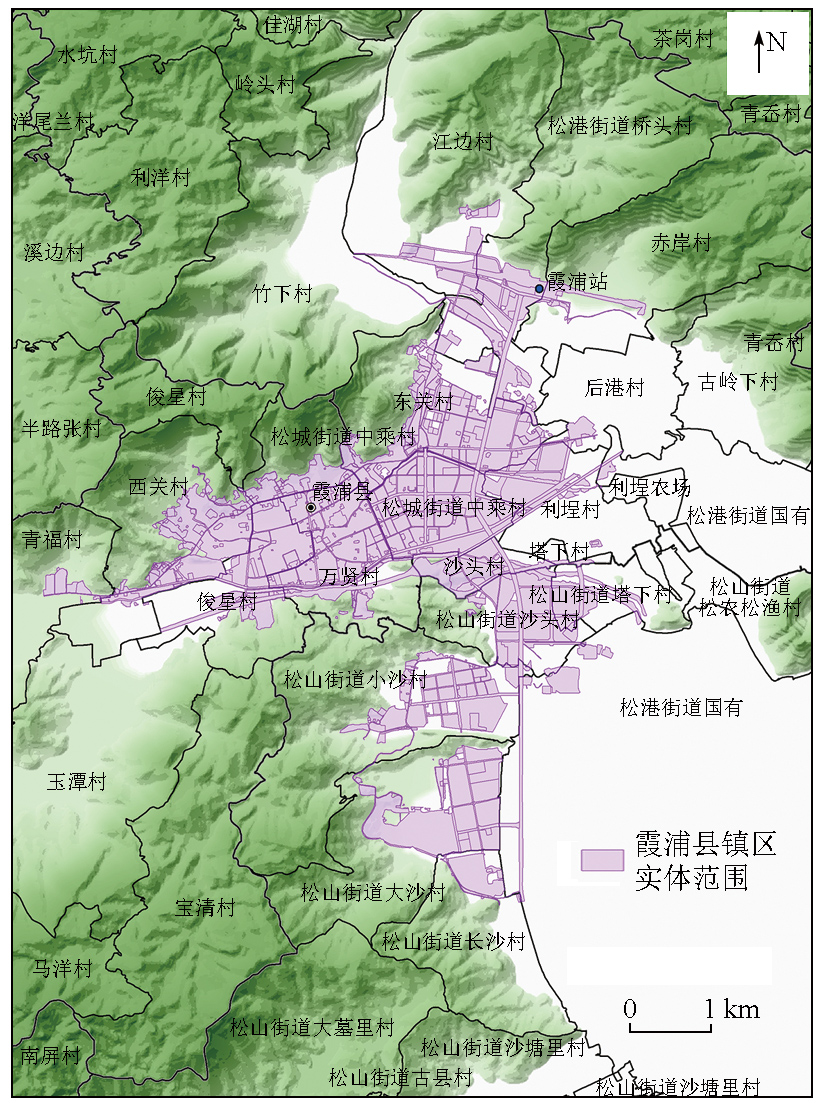
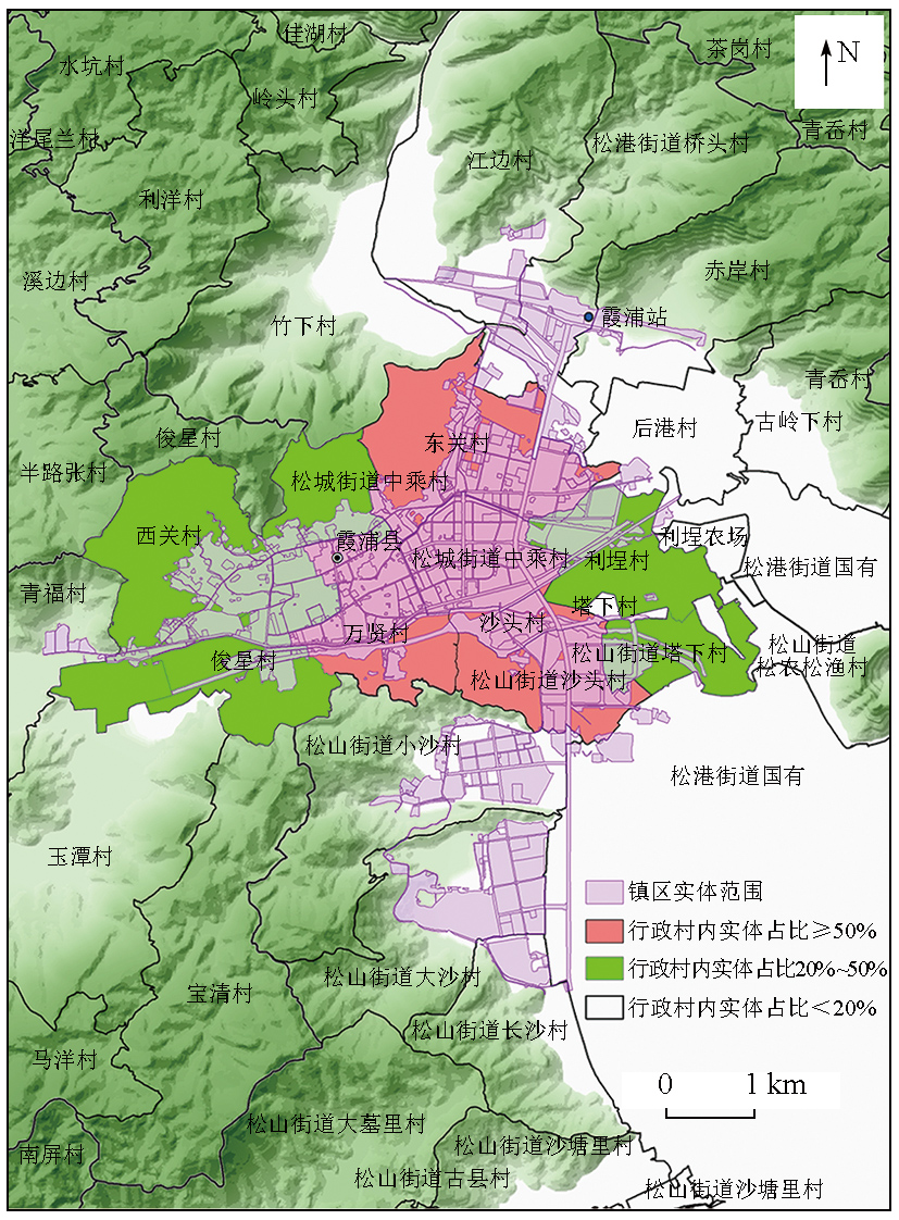
Scientifically and rationally demarcating urban and town areas is a fundamental task during China’s rapid urbanization stage. It serves as a critical basis for promoting the optimization and quality improvement of urban and rural spaces, scientifically coordinating urban and rural planning and construction management, and implementing territorial spatial planning. However, there is neither a unified concept nor a universal delimitation method for urban and town areas in China, hindering their planning, construction, development, and public management. Based on defining the relevant concepts of urban and town areas, this study proposed a people-centered method for determining town areas with no cities and counties set using geographic information system (GIS) technology, considering the characteristics and spatial relationships of land types. The data sources of this study include the results of the third national land resource survey, statistical bulletins, remote sensing image interpretation, and point-of-interest (POI) data. Finally, the proposed method was applied to demarcate the town areas in Xiapu County, Ningde City. The empirical study results demonstrate the effectiveness of the proposed method, which features a scientific and concise technology roadmap and strong operability. Therefore, the proposed method can provide a theoretical foundation for the rational territorial spatial planning.
徐瑶瑶, 吴涵宇, 于俊杰, 朱一姝, 王继龙, 彭博. 镇区范围空间划定方法研究——以福建省宁德市霞浦县为例[J]. 自然资源遥感, 2025, 37(4): 163-172.
XU Yaoyao, WU Hanyu, YU Junjie, ZHU Yishu, WANG Jilong, PENG Bo. A spatial demarcation method for town areas: A case study of Xiapu County, Ningde City, Fujian. Remote Sensing for Natural Resources, 2025, 37(4): 163-172.
Long Y, Wu K. Several emerging issues of China’s urbanization:Spatial expansion,population shrinkage,low-density human activities and city boundary delimitation[J]. Urban Planning Forum, 2016,(2):72-77.
Qi W, Wang K Y. City administrative area and physical area in China:Spatial differences and integration strategies[J]. Geographical Research, 2019, 38(2):207-220.
[3]
汪阳. 我国城乡划分标准研究[D]. 成都: 西南交通大学, 2012.
Wang Y. Study on the criteria of urban-rural division in China[D]. Chengdu: Southwest Jiaotong University, 2012.
Yi X X, Dong W, Zhang H. Standards,methods and evolution of US urban area delineation:Fine delineation reflecting physical territory concept[J]. Urban Planning International, 2021, 36(1):69-75.
Zhou Y X, Shi Y L. Toward establishing the concept of physical urban area in China[J]. Acta Geographica Sinica, 1995, 50(4):289-301.
doi: 10.11821/xb199504001
Hui Y, Jin Z F, Chen W. Study on urban-rural area division and urban population counting——The case of Changshu city[J]. Areal Research and Development, 2009, 28(1):42-46.
Song X D, Liu P, Zhou Y X. Urban and rural area division:Taking Shanghai as an example[J]. Acta Geographica Sinica, 2006, 61(8):787-797.
doi: 10.11821/xb200608001
[8]
冯健. 城乡划分与监测[M]. 北京: 科学出版社, 2012.
Feng J. Urban and rural division and monitoring[M]. Beijing: Science Press, 2012.
Xu Q, Hua C. Establishing a uniform standard for calculation of urban built-up area—with Hangzhou central city zone as an example[J]. Planners, 2005, 21(4):88-91.
Hua C, Hong Y D, Wang Y F, et al. The concept and definition of urban built-up area:A case study of Wukang town in Zhejiang Province[J]. Urban Planning Forum, 2013(2):57-62.
Hu Y D, Wu Z H, Xiong W, et al. Study on the definition method of urban built-up area—Taking Wuhan as an example[J]. City Planning Review, 2008, 32(4):88-91,96.
Chen H, Tao C, Zou Z R, et al. Automatic urban area extraction using a Gabor filter and high-resolution remote sensing imagery[J]. Geomatics and Information Science of Wuhan University, 2013, 38(9):1063-1067.
Zhou J, Chen H J, Xie B. Study on the method of metropolitan area delimitation based on multi-data:A case study of Wuhan[J]. Shanghai Urban Planning Review, 2017(2):70-75.
[15]
Wang H, Ning X, Zhang H, et al. Urban boundary extraction and urban sprawl measurement using high-resolution remote sensing images:A case study of China’s provincial capital[C]// International Archives of the Photogrammetry,Remote Sensing and Spatial Information Sciences, 2018.
[16]
Zhang X, Du S, Wang Q. Integrating bottom-up classification and top-down feedback for improving urban land-cover and functional-zone mapping[J]. Remote Sensing of Environment, 2018, 212:231-248.
Zhou X C, Liu Y M, Yang H J. Spatial recognition and boundary region division of urban fringe area in Xi’an City[J]. Journal of Geo-Information Science, 2017, 19(10):1327-1335.
Yuan Y P, Hua Y P, Xue X Y, et al. Urban boundary extraction and dynamic change based on multisource remote sensing data[J]. Science of Surveying and Mapping, 2022, 47(2):110-116.
Wang D, Gu J H, Yan L X. Delimiting the Shanghai metropolitan area using mobile phone data[J]. Acta Geographica Sinica, 2018, 73(10):1896-1909.
doi: 10.11821/dlxb201810006
Fang B, Zhang X Z, Yang L. Study on urban boundary identification based on POI:A case study of Yuncheng City in Shanxi[J]. Modern Surveying and Mapping, 2017, 40(5):20-22.
Xu Z N, Gao X L. A novel method for identifying the boundary of urban built-up areas with POI data[J]. Acta Geographica Sinica, 2016, 71(6):928-939.
doi: 10.11821/dlxb201606003
Wu J, Liu C, Ying S, et al. Spatial delineation methods of urban areas[J]. Remote Sensing for Natural Resources, 2021(4):89-97.doi:10.6046/zrzyyg.2021015.
Zhang H, Zhao Z Q, Chen Y Z. A preliminary study on method,condition and procedure of urban area identification under the background of territorial development planning:Taking Jingdezhen of Jiangxi Province as an example[J]. Urban Planning Forum, 2020(4):51-57.
Xu H, Wang W W. Research on the identification of town area scope under the new planning system in the new era——taking Anhai Town of Jinjiang City as an example[C]// Urban Planning Society of China.People’s City,Planning Empowerment——Proceedings of the 2022 China Urban Planning Annual Conference (20 Master Planning). Guangzhou: Guangzhou Urban Planning, Survey and Design Institute, 2023: 9.
National Bureau of Statistics. Provisions for the statistical division of urban and rural areas[EB/OL]. https://www.stats.gov.cn/sj/tjbz/gjtjbz/202302/t20230213_1902742.html.
National Bureau of Statistics. Urban (county) and rural areas construction statistical survey system[EB/OL]. https://www.stats.gov.cn/fw/bmdcxmsp/bmzd/202302/t20230215_1907097.html.
The State Council. Notice of the State Council on readjustment of the standards for the division of urban dimensions[EB/OL]. http://www.gov.cn/zhengce/content/2014-11/20/content_9225.htm.
Ministry of Construction of the People’s Republic of China. GB/T 50280—1998 Standard for basic terminology of urban planning[S]. Beijing: China Architecture Publishing, 1999.
Ministry of Natural Resources of the People’s Republic of China. TD/T 1063—2021 Code of practice for city examination & evaluation in spatial planning[S]. Beijing: Geological Publishing House, 2021.
Wang J L, Lin F Z, Peng B, et al. Evaluation and practice of urban construction suitability in coastal volcanic areas of southeast China:A case study of Ningde City,Fujian Province[J]. East China Geology, 2022, 43(4):490-502.
Zhang D Y, Zhang J, Niu X N, et al. Exploration on dual evaluation theory and the practice in Fujian Province[J]. East China Geology, 2021, 42(4):419-428.
Office of the Third National Land Survey. Notice of the office of the third national land survey on the issuance of the implementation plan for the third national land survey[EB/OL]. http://gi.mnr.gov.cn/201811/t20181120_2367135.html.
Chinese Land Surveying and Planning Institute,Division of Natural Resources Survey and Monitoring,Ministry of Natural Resources. TD/T 1055—2019 Technical regulations for the third national land survey[S]. Beijing: Geological Publishing House, 2019.
Lin F Z. Understanding and thinking on formulating overall planning of municipal territorial space in the new era:A case study of Ningde City,Fujian Province[J]. East China Geology, 2021, 42(4):409-418.
 2025, Vol. 37
  ), 吴涵宇, 于俊杰, 朱一姝, 王继龙, 彭博(