

0 引言
目前已有多种从热红数据中获取LST的算法[7
1 数据源
1.1 SDGSAT-1热红外数据
表1 SDGSAT-1卫星热红外光谱仪技术指标
Tab.1
| 项目 | 指标 |
|---|---|
| 幅宽/km | 300 |
| 波段范围/μm | 8~10.5 10.3~11.3 11.5~12.5 |
| 空间分辨率/m | 30 |
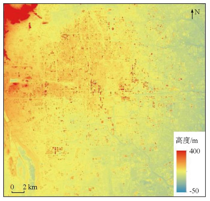
1.2 DSM数据
图1
1.3 ECMWF大气廓线数据
大气参数可通过欧洲中期天气预报中心(ECMWF)的大气剖面数据集(
2 研究方法
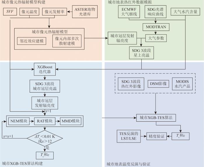
城市XGB-TES算法结合了XGBoost算法和机器学习中的TES算法,同时考虑了城市几何形状的影响。该算法的技术路线如图2所示,共有3个步骤,将该算法应用于北京市的SDGSAT-1热红外影像中,然后进行了详细分析。
图2
2.1 城市像元热辐射传输模型构建
城市像元热红外辐射传输(UPT-RT)模型是本研究的基础和核心,它区别于平面热辐射传输模型。在平面热辐射传输模型的基础上,考虑了城市几何结构造成的像元内多次散射、邻近像元的辐射以及城市建筑物遮挡造成的大气向下辐射减少。在考虑城市像元内部多次散射情况下,城市像元有效发射率
式中:
鉴于城市表面可视为离散的柱状体而非连续的三角面,Zakšek等[23]提出了一种计算 SVF 的方法,其计算公式为:
式中:
城市像元热辐射
式中:
在城市像元热辐射传输模型中,假设邻近像元与目标像元具有相同的LST和LSE,邻近像元辐射
式中:
因此,最终星上观测到的城市像元热辐射表达式为:
式中:
2.2 基于XGBoost的城市冠层亮温反演
式中:
1)构建模拟数据: 可靠地训练和测试数据库是机器学习算法的基础;
2)训练XGBoost模型,具体过程如下:
①训练集和测试集的分割: 在编码过程中,70%的模拟数据被分割成训练集,20%的模拟数据被分割成验证集,剩下的10%作为测试集。数据集分为2组: 含大气水汽含量(water vapor content,WVC)的3个SDGSAT-1热红外波段、
②对XGBoost的输入特征进行了归一化处理,以提高模型的收敛速度;
③构建XGBoost框架: 优化对XGBoost估算器性能有重大影响的参数是构建最优XGBoost框架的关键。本文采用网格搜索法获得最优参数。
2.3 改进的TES城市LST/LSE反演模型
Gillespie等[9]提出了TES算法,该算法利用ASTER的5个热红外波段同时反演LST和LSE,并且已经很好地应用于许多卫星的热红外传感器中,而SDGSAT-1卫星具有3个热红外波段,这意味着它可以同时接收来自地表的多个不同波段的热辐射。TES算法正是基于这一多波段观测的特性,通过利用不同波段的热辐射数据,对LST和LSE进行分离和反演。因此,本文基于TES算法进行了SDGSAT-1卫星的城市LST/LSE反演。TES算法由3个模块组成: LSE归一化模块(normalize emissivity method,NEM)、最大最小差值模块(maximum mean discrepancy,MMD)和比值注意力模块(ratio attention module,RAT)。传统的TES算法没有考虑城市几何效应的修正,为了实现具有三维结构形态的城市LST高精度反演,本文通过引入SVF参数对TES算法进行修正,地表出射辐射
NEM模块中,通过校正大气下行辐射
式中:
式中:
RAT模块中,每个波段的LSE与LSE平均值之比计算公式为:
式中:
最大均值差异(maximum mean discrepancy,MMD)模块中,构建了最小发射率和MMD之间的经验关系,以确保方程组可解。关系式为[9]:
其中,
图3
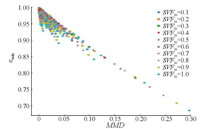
表2 不同SVFin值下 MMD 模块的系数和发射率RMSE
Tab.2
| 系数 | ||||
|---|---|---|---|---|
| a | b | c | RMSE | |
| 0.1 | 0.996 5 | 1.229 9 | 1.028 4 | 0.001 6 |
| 0.2 | 0.993 1 | 1.164 0 | 1.021 3 | 0.003 2 |
| 0.3 | 0.989 8 | 1.118 3 | 1.014 4 | 0.004 7 |
| 0.4 | 0.986 4 | 1.082 3 | 1.007 9 | 0.006 2 |
| 0.5 | 0.983 2 | 1.052 2 | 1.001 7 | 0.007 6 |
| 0.6 | 0.980 0 | 1.026 4 | 0.995 7 | 0.009 1 |
| 0.7 | 0.976 8 | 1.003 6 | 0.989 9 | 0.010 5 |
| 0.8 | 0.973 6 | 0.983 4 | 0.984 4 | 0.011 9 |
| 0.9 | 0.970 5 | 0.965 1 | 0.979 0 | 0.013 2 |
| 1.0 | 0.967 4 | 0.948 4 | 0.973 9 | 0.014 6 |
根据最小LSE重新计算每个波段的LSE,公式为:
城市像元LST计算公式为:
式中
3 城市LST反演精度评价及其应用
3.1 城市冠层亮温反演精度评价
为了评价基于XGBoost的城市冠层亮温反演精度,本文采用了Zheng等[25]使用的分裂窗(split window, SW)算法进行交叉验证,SW算法计算公式为:
式中,
图4
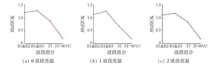
表3 XGBoost和SW算法最佳波段组合结果对比
Tab.3
| 波段组合 | B1&B2 | 3T | 3T+WVC | B1&B2 | 3T | 3T+WVC | B1&B2 | 3T | 3T+WVC |
| RMSE/K | 1.21 | 0.88 | 0.21 | 1.13 | 0.68 | 0.19 | 1.11 | 0.85 | 0.19 |
3.2 XGB-TES算法精度评价
鉴于卫星同步的地面实测LST数据获取困难,本研究使用了模拟数据集来验证XGB-TES算法的精度,分别在有/无水汽的条件下使用XGB-TES算法反演了城市LST/LSE。图5显示了实际与反演LST/LSE之差累计概率分布情况,在有WVC数据的情况下, LST和3个波段的LSE反演精度均有所提高,其中LSE反演误差主要分布在0附近。对比图5(a)-(c)可以看出,波段1的LSE RMSE最大,在有/无WVC数据时分别为0.020和0.026。相比之下,波段2的LSE RMSE最小,在有/无WVC数据时分别为0.018和0.023。图5(d)表明,增加WVC后,LST的RMSE从0.73 K降低到了0.36 K,并且RMSE的波动范围显著减小,异常值也减少了。
图5
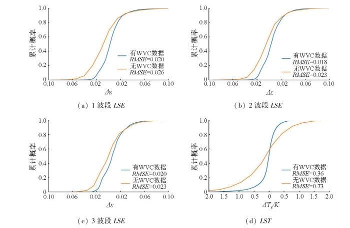
图5
实际与反演LST/LSE之差累计概率分布图
Fig.5
Cumulative probability distribution of the difference between actual and retrieved LST/LSE
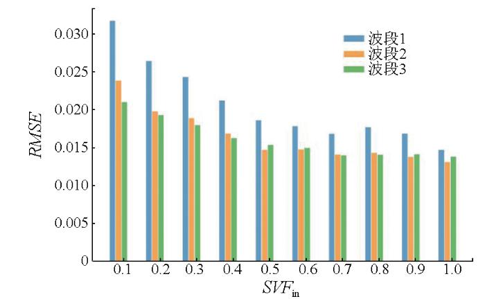
图6显示了城市XGB-TES算法反演的3个SDGSAT-1热红外波段LSE RMSE(
图6
为了获取
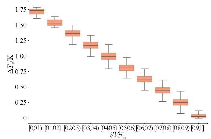
图7
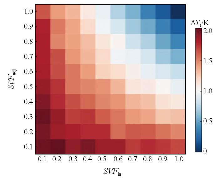
图7
不同
Fig.7
Difference between LST obtained by the TES algorithm and the XGB-TES algorithm for different groups of SVFin and SVFadj
3.3 实际应用与验证
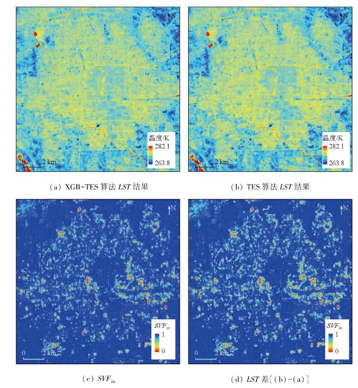
为了验证本文所提出的城市XGB-TES算法的可行性,选取了北京市北京时间2023年11月26日(过境时间: 01:29)的SDGSAT-1热红外影像反演LST/LST。图8显示了考虑城市几何形状的城市XGB-TES算法与传统TES算法所获取的LST在空间分布上的差异。图8(a)显示了城市XGB-TES算法获取的LST,图8(b)显示了不考虑几何效应的TES算法获取的LST,图8(c)为北京市城区计算所得
图8
此外,本文分析了
图9
4 讨论与结论
本研究结合XGBoost算法和改进的TES算法,提出了适用于SDGSAT-1卫星城市下垫面LST反演的XGB-TES算法,同时反演出了LST和LSE。以下是本研究得出的结论。
1)从模拟数据的结果来看,XGB-TES算法精度较高。从星上亮温到城市冠层亮温的RMSE优于0.21 K,远高于传统的SW算法(大于1.11 K); XGB-TES算法在LST反演的RMSE约为0.36 K,优于传统的TES算法(0.82 K); SDGSAT-1 3个波段的LSE RMSE均优于0.020,其中波段1的LSE误差明显大于其他波段。然而,该算法的准确性还需要通过现场测量数据的进一步验证。
2)准确的WVC数据可以有效提高城市LST和LSE的反演精度。与不考虑WVC的反演结果相比,LST RMSE从0.73 K提高到0.36 K,SDGSAT-1 3波段的LSE RMSE提高了0.003~0.006。
3) 相比于传统TES算法,改进后的TES算法校正了城市三维结构对城市热辐射的影响,温差取值范围在0~1.86 K之间,大部分在0.2~0.8 K之间,LST存在显著差异的区域主要分布在复杂的地形区,与SVF高度相关。
但本研究还存在以下不足: 首先,由于现有的一些地面验证数据是基于均匀、平坦的地表下获得的,对于城市这样结构复杂、不均匀的地表下很难进行,本文仅验证了所构建算法的理论精度; 其次,在构建城市热辐射传输模型时,为了简化计算,假设城市地表是等温的,像素内不同成分之间没有温差,也没有阴影覆盖,这与实际情况不符; 最后,由于遥感影像数据(如通过MODIS获取的WVC数据、DSM数据等)不可避免地存在一定的误差,尚未验证上述误差对LST反演结果的不确定度。
针对以上不足,在未来工作中,可通过无人机获取实时城市LST数据以支持算法的构建; 其次,在以后的研究中可进一步对现有复杂模型进行参数化,在保证精度的情况下建立新的城市像元LST反演模型; 最后,在未来的工作中,针对WVC数据、TOA辐亮度以及SVF等输入参数开展不确定度分析,以验证算法的稳定性。
参考文献
Evaluation of a temporal fire risk index in Mediterranean forests from NOAA thermal IR
[J].
Constraining global changes in temperature and precipitation from observable changes in surface radiative heating
[J].
A four-component parameterized directional thermal radiance model for row canopies
[J].
A simple interpretation of the surface temperature/vegetation index space for assessment of surface moisture status
[J].
Satellite remote sensing of global land surface temperature:Definition,methods,products,and applications
[J].
The concept of essential climate variables in support of climate research,applications,and policy
[J].
A mono-window algorithm for retrieving land surface temperature from Landsat TM data and its application to the Israel-Egypt border region
[J].
Towards a local split window method over land surfaces
[J].
A temperature and emissivity separation algorithm for Advanced Spaceborne Thermal Emission and Reflection Radiometer (ASTER) images
[J].
Temperature and emissivity retrieval from hyperspectral thermal infrared data using dictionary-based sparse representation for emissivity
[J].
热红外地表温度遥感反演方法研究进展
[J].
Review of methods for land surface temperature derived from thermal infrared remotely sensed data
[J].
Geometry and adjacency effects in urban land surface temperature retrieval from high-spatial-resolution thermal infrared images
[J].
An extended SW-TES algorithm for land surface temperature and emissivity retrieval from ECOSTRESS thermal infrared data over urban areas
[J].
Seasonal variations of daytime land surface temperature and their underlying drivers over Wuhan,China
[J].
Modeling the effective emissivity of the urban canopy using sky view factor
[J].
Development of an improved urban emissivity model based on sky view factor for retrieving effective emissivity and surface temperature over urban areas
[J].
XGBoost:A scalable tree boosting system
[C]//
Temporal expansion of the nighttime light images of SDGSAT-1 satellite in illuminating ground object extraction by joint observation of NPP-VIIRS and sentinel-2A images
[J].
SDGSAT-1:The world’s first scientific satellite for sustainable development goals
[J].
Graphical estimation of sky view-factors in urban environments
[J].
HORAYZON v1.2:An efficient and flexible ray-tracing algorithm to compute horizon and sky view factor
[J].
MODTRAN (R) 5.3.2 User’s Manual
[J].
Sky-view factor as a relief visualization technique
[J].
Estimating gaseous pollutants from bus emissions:A hybrid model based on GRU and XGBoost
[J].
Determination of global land surface temperature using data from only five selected thermal infrared channels:Method extension and accuracy assessment
[J].
