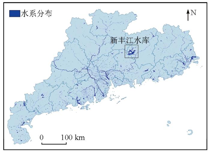
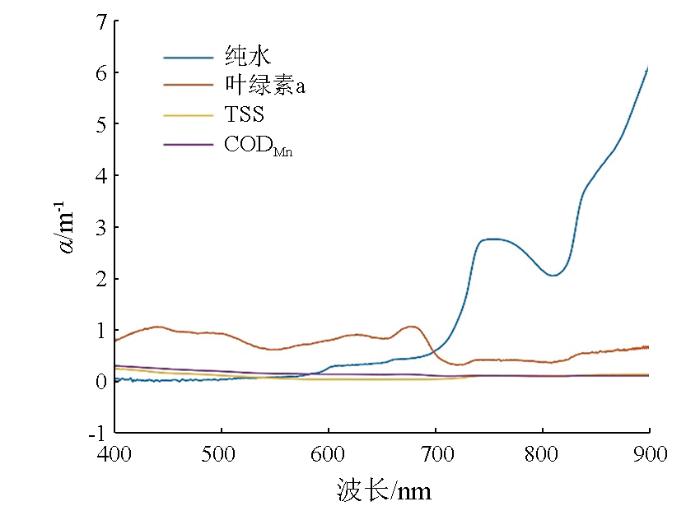
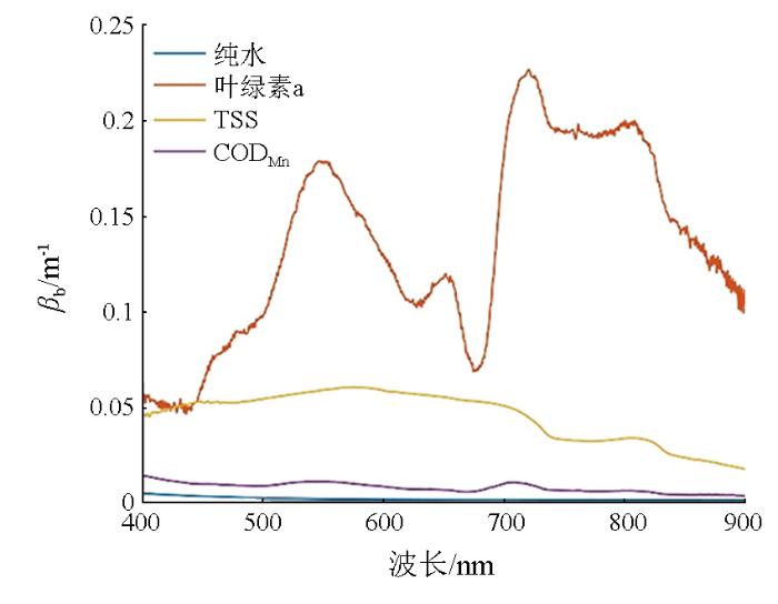
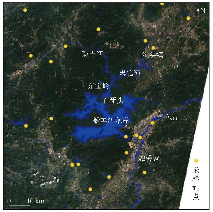
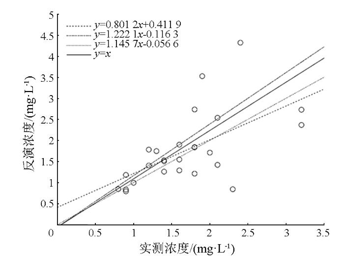
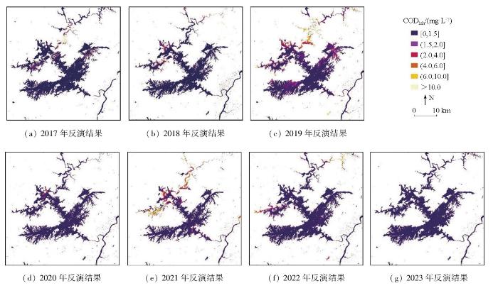
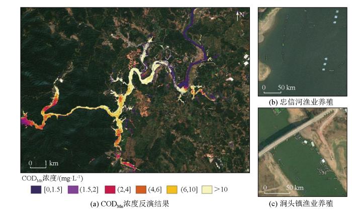
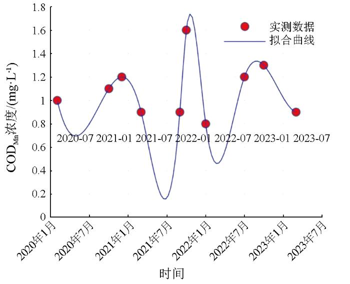
To protect the water quality of the Xinfengjiang Reservoir and monitor the eutrophication risk,this study developed an analytical model for remote sensing inversion of chemical oxygen demand (CODMn) based on the underwater radiative transfer process. This model comprehensively takes into account three water quality parameters that influence the underwater light field:chlorophyll a,total suspended matter,and CODMn. The model was applied to conduct multi-temporal monitoring of eutrophication in the reservoir and its surrounding rivers. Through accuracy verification,the model achieved a root mean square error of 0.68 and a mean absolute percentage error of 25.22%,demonstrating its reliability in complex water environments. The spatiotemporal analysis of the water quality in Xinfengjiang Reservoir revealed the consistent good quality of the main body over the long term. However,due to extensive aquaculture and anthropogenic discharges,the Zhongxin River exhibited frequent eutrophication,which may pose a potential threat to the overall water quality of the reservoir. It is recommended to enhance monitoring of the Zhongxin River,promptly address illegal discharges,and implement ecological engineering measures such as vegetative drainage ditches in the watershed. These efforts can effectively reduce agricultural non-point source pollution,contributing to the restoration and improvement of the ecological environment of Xinfengjiang Reservoir.
KUANG Zhiyuan, DENG Ruru. Multi-temporal remote sensing monitoring of chemical oxygen demand in Xinfengjiang Reservoir[J]. Remote Sensing for Land & Resources, 2025, 37(5): 44-52 doi:10.6046/zrzyyg.2024301
Spatiotemporal analysis of water quality indicators in small lakes using sentinel-2 satellite data:Lake Bloomington and evergreen lake,central Illinois,USA
Remote-sensing reflectance is easier to interpret for the open ocean than for coastal regions because the optical signals are highly coupled to the phytoplankton (e.g., chlorophyll) concentrations. For estuarine or coastal waters, variable terrigenous colored dissolved organic matter (CDOM), suspended sediments, and bottom reflectance, all factors that do not covary with the pigment concentration, confound data interpretation. In this research, remote-sensing reflectance models are suggested for coastal waters, to which contributions that are due to bottom reflectance, CDOM fluorescence, and water Raman scattering are included. Through the use of two parameters to model the combination of the backscattering coefficient and the Q factor, excellent agreement was achieved between the measured and modeled remote-sensing reflectance for waters from the West Florida Shelf to the Mississippi River plume. These waters cover a range of chlorophyll of 0.2-40 mg/m(3) and gelbstoff absorption at 440 nm from 0.02-0.4 m(-1). Data with a spectral resolution of 10 nm or better, which is consistent with that provided by the airborne visible and infrared imaging spectrometer (AVIRIS) and spacecraft spectrometers, were used in the model evaluation.
NeilC, SpyrakosE, HunterP D, et al.
A global approach for chlorophyll-a retrieval across optically complex inland waters based on optical water types
[J]. Remote Sensing of Environment, 2019, 229:159-178.
Numerous algorithms have been developed to retrieve chlorophyll-a (Chla) concentrations (mg m(-3)) from Earth observation (EO) data collected over optically complex waters. Retrieval accuracy is highly variable and often unsatisfactory where Chla co-occurs with other optically active constituents. Furthermore, the applicability and limitations of retrieval algorithms across different optical complex systems in space and time are often not considered. In the first instance, this paper provides an extensive performance assessment for 48 Chla retrieval algorithms of varying architectural design. The algorithms are tested in their original parametrisations and are then retuned using in-situ remote sensing reflectance (R-rs(lambda), sr(-1)) data (n = 2807) collected from 185 global inland and coastal aquatic systems encompassing 13 different optical water types (OWTs). The paper then demonstrates retrieval performance across the full dataset of observations and within individual OWTs to determine the most effective model(s) of those tested for retrieving Chla in waters with varying optical properties. The results revealed significant variability in retrieval performance when comparing model outputs to in-situ measured Chla for the full in-situ dataset in its entirety and within the 13 distinct OWTs. Importantly, retuning an algorithm to optimise its parameterisation for each individual OWT (i.e. one algorithm, multiple parameterisations) is found to improve the retrieval of Chla overall compared to simply calibrating the same algorithm using the complete in-situ dataset (i.e. one algorithm, one parameterisation). This resulted in a 25% improvement in retrieval accuracy based on relative percentage difference errors for the best performing Chla algorithm. Improved performance is further achieved by allowing model type and specific parameterisation to vary across OWTs (i.e. multiple algorithms, multiple parameterisations). This adaptive framework for the dynamic selection of in-water algorithms is shown to provide overall improvement in Chla retrieval across a continuum of bio-geo-optical conditions. The final dynamic ensemble algorithm produces estimates of (log(10)-transformed) Chla with a correlation coefficient of 0.89 and a mean absolute error of 0.18 mg m(-3). The OWT framework presented in this study demonstrates a unified approach by bringing together an ensemble of algorithms for the monitoring of inland waters at a global scale from space.
GuoQ, ZhangD J, CaoL J, et al.A remote sensing method to inverse chemical oxygen demand in Qinghai Lake[C]// 2021 IEEE International Geoscience and Remote Sensing Symposium IGARSS. IEEE, 2021:3697-3700.
A hybrid remote sensing approach for estimating chemical oxygen demand concentration in optically complex waters:A case study in inland lake waters in Eastern China
[J]. Science of The Total Environment, 2023, 856:158869.
HuC H.Study on the loss of fertilizer,nitrogen and phosphorus from farmland in a small watershed in the catchment area of Xinfengjiang reservoir,Guangdong province and its environmental fate[D]. Xi’an: Shaanxi University of Science and Technology, 2023.
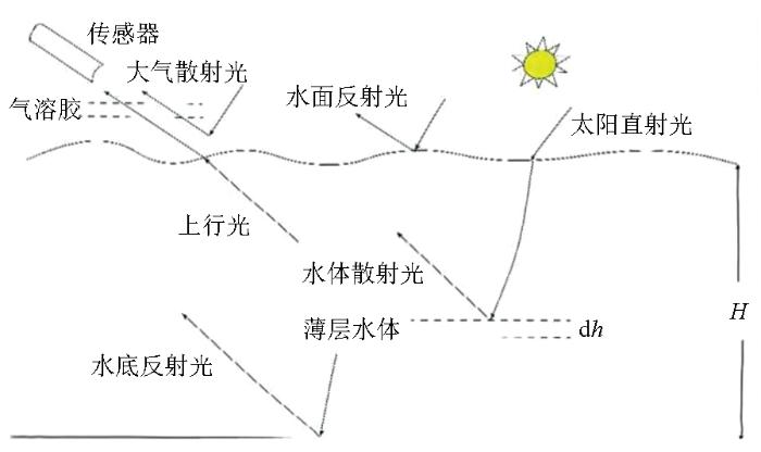
For analytical or semianalytical retrieval of shallow-water bathymetry and/or optical properties of the water column from remote sensing, the contribution to the remotely sensed signal from the water column has to be separated from that of the bottom. The mathematical separation involves three diffuse attenuation coefficients: one for the downwelling irradiance (K(d)), one for the upwelling radiance of the water column (K(u)(C)), and one for the upwelling radiance from bottom reflection (K(u)(B)). Because of the differences in photon origination and path lengths, these three coefficients in general are not equal, although their equality has been assumed in many previous studies. By use of the Hydrolight radiative-transfer numerical model with a particle phase function typical of coastal waters, the remote-sensing reflectance above (R(rs)) and below (r(rs)) the surface is calculated for various combinations of optical properties, bottom albedos, bottom depths, and solar zenith angles. A semianalytical (SA) model for r(rs) of shallow waters is then developed, in which the diffuse attenuation coefficients are explicitly expressed as functions of in-water absorption (a) and backscattering (b(b)). For remote-sensing inversion, parameters connecting R(rs) and r(rs) are also derived. It is found that r(rs) values determined by the SA model agree well with the exact values computed by Hydrolight (~3% error), even for Hydrolight r(rs) values calculated with different particle phase functions. The Hydrolight calculations included b(b)/a values as high as 1.5 to simulate high-turbidity situations that are occasionally found in coastal regions.
Spatiotemporal analysis of water quality indicators in small lakes using sentinel-2 satellite data:Lake Bloomington and evergreen lake,central Illinois,USA
A hybrid remote sensing approach for estimating chemical oxygen demand concentration in optically complex waters:A case study in inland lake waters in Eastern China


