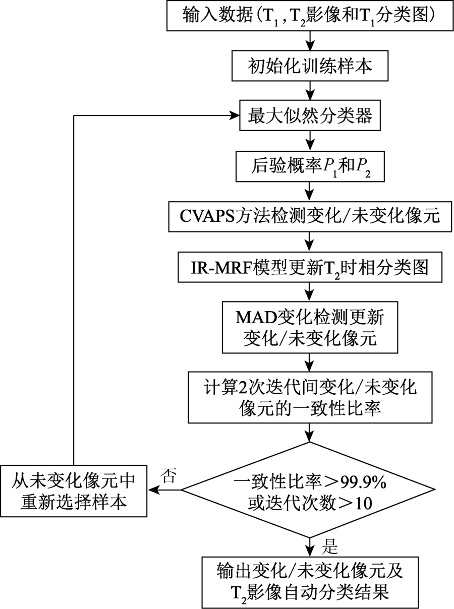
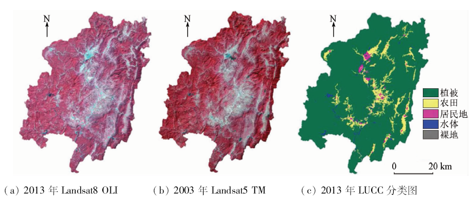
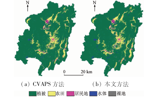
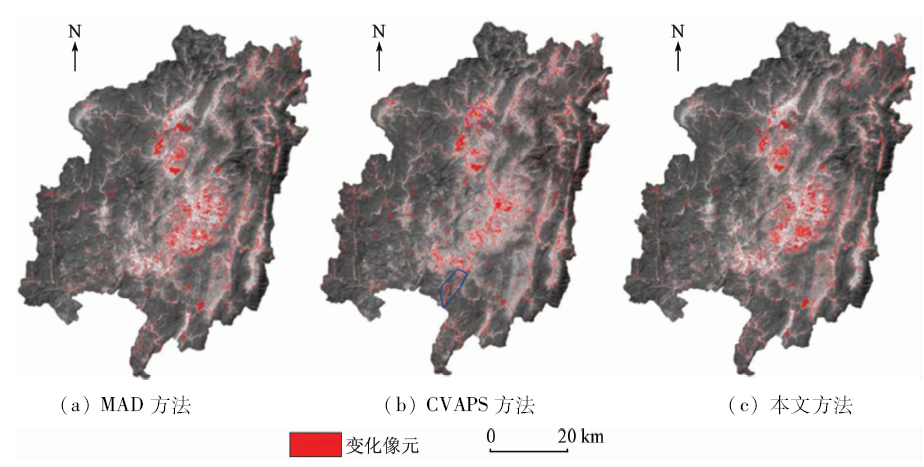
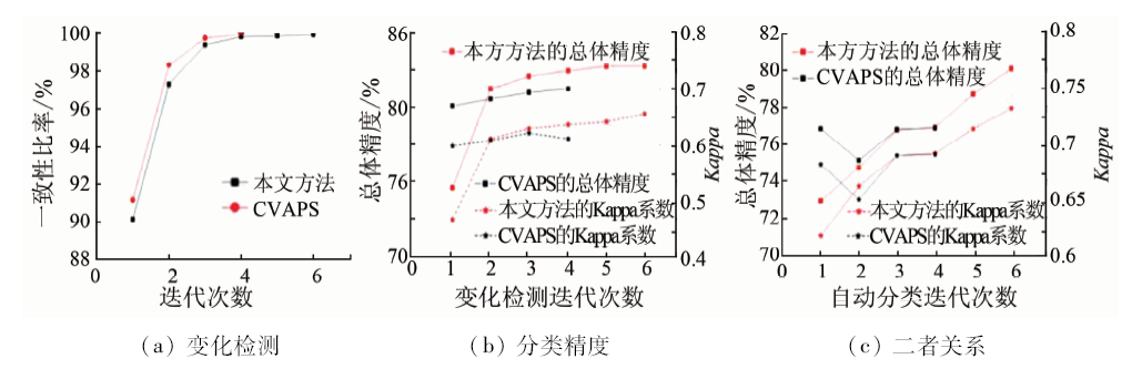
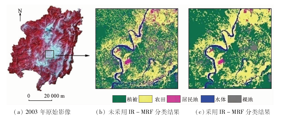
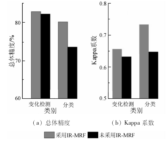
后验概率变化矢量分析(change vector analysis in posterior probability space,CVAPS)方法没有顾及到遥感影像波段之间和多时相之间的光谱相关性,可能会造成信息丢失而降低影像变化检测的精度。因此,结合多元变化检测(multivariate change detection,MAD)技术与CVAPS方法,提出一种改进的土地利用/覆盖变化(land use/cover change,LUCC)分类自动更新方法。首先,引入MAD技术来降低多光谱影像波段间相关性的影响,从而改善对像元变化检测的精度,增强LUCC分类自动更新过程中训练样本的可靠性,提高LUCC分类自动更新的精度; 然后,为减少分类图中“椒盐”噪声的影响,进一步利用迭代马尔科夫随机场(iterative Markov random field,IR-MRF)模型进行分类后空间邻域处理,以提高自动更新的精度。以福建省长汀县2013年获取的Landsat8影像数据以及相应的LUCC分类图为基准,利用2003年获取的Landsat5影像,对长汀县2003年的LUCC进行更新。实验结果表明,该方法的自动更新总体精度能够达到80%,比单独采用CVAPS方法的自动更新精度提高了约3%。
The method of change vector analysis in posterior probability space(CVAPS) does not take into consideration the correlation between the bands of remote sensing image, which may result in unreliable change detection. In view of such a situation, the authors introduced multivariate change detection(MAD)method and, in combination with CVAPS, proposed an improved method for automatic updating of land use / cover change(LUCC) classification. The method firstly introduces MAD to reduce bands-correlation for improving the reliability of train-samples and accordingly improving LUCC updating maps, and then included an iterative Markov random field(IR-MRF)model to fully employ the contextual information in post-processing to reduce the noise of “salt-and-pepper”. Choosing Changting County of Fujian Province as the study area, the authors used Landsat5 TM and Landsat8 OLI data acquired in 2003 and 2013 respectively, and took OLI as the base image to update the classification map in 2003. The experimental results show that the proposed method significantly outperforms the CVAPS in that its overall accuracy could reach 80% with the improvement rate being about 3%.
Wang X L, Bao Y H . Study on the methods of land use dynamic change research[J]. Progress in Geography, 1999,18(1):81-87.
[4]
Turner II B L,Meyer W B,Skole D L. Global land-use/land-cover change:Towards an integrated study[J]. Ambio, 1994,23(1):91-95.
doi: 10.1080/02786829408959678
Sun X X, Zhang J X, Yan Q , et al. A summary on current techniques and prospects of remote sensing change detection[J]. Remote Sensing Information, 2011,26(1):119-123.
[6]
Chen X H, Chen J, Shi Y S , et al. An automated approach for updating land cover maps based on integrated change detection and classification methods[J]. ISPRS Journal of Photogrammetry and Remote Sensing, 2012,71:86-95.
doi: 10.1016/j.isprsjprs.2012.05.006
[7]
Xian G, Homer C, Fry J.Updating the 2001 national land cover database land cover classification to 2006 by using Landsat imagery change detection methods[J]. Remote Sensing of Environment, 2009,113(6):1133-1147.
doi: 10.1016/j.rse.2009.02.004
[8]
Xian G, Homer C .Updating the 2001 national land cover database impervious surface products to 2006 using Landsat imagery change detection methods[J]. Remote Sensing of Environment, 2010,114(8):1676-1686.
doi: 10.1016/j.rse.2010.02.018
[9]
Jin S M, Yang L M, Danielson P , et al.A comprehensive change detection method for updating the national land cover database to circa 2011[J].Remote Sensing of Environment, 2013,132:159-175.
doi: 10.1016/j.rse.2013.01.012
[10]
Chen J, Chen X H, Cui X H , et al. Change vector analysis in posterior probability space:A new method for land cover change detection[J]. IEEE Geoscience and Remote Sensing Letters, 2011,8(2):317-321.
doi: 10.1109/LGRS.2010.2068537
[11]
张路 . 基于多元统计分析的遥感影像变化检测方法研究[D]. 武汉:武汉大学, 2004.
Zhang L . Change Detection in Remotely Sensed Imagery Using Multivariate Statistical Analysis[D]. Wuhan: Wuhan University, 2004.
Sheng H, Liao M S, Zhang L . Determination of threshold in change detection based on canonical correlation analysis[J]. Journal of Remote Sensing, 2004,8(5):451-457.
Liao M S, Zhu P, Gong J Y . Multivariate change detection based on canonical transformation[J]. Journal of Remote Sensing, 2000,4(3):197-201,246.
[14]
Nielsen A A, Conradsen K, Simpson J J . Multivariate alteration detection(MAD) and MAF postprocessing in multispectral,bitemporal image data:New approaches to change detection studies[J]. Remote Sensing of Environment, 1998,64(1):1-19.
doi: 10.1016/S0034-4257(97)00162-4
[15]
Nielsen A A . The regularized iteratively reweighted MAD method for change detection in multi-and hyperspectral data[J]. IEEE Transactions on Image Processing, 2007,16(2):463-478.
doi: 10.1109/TIP.2006.888195
pmid: 17269639
[16]
Kapur J N, Sahoo P K, Wong A K C.A new method for gray-level picture thresholding using the entropy of the histogram[J]. Computer Vision,Graphics,and Image Processing, 1985,29(3):273-285.
doi: 10.1016/0734-189X(85)90125-2
[17]
Bruzzone L, Prieto D F . Automatic analysis of the difference image for unsupervised change detection[J]. IEEE Transactions on Geoscience and Remote Sensing, 2000,38(3):1171-1182.
doi: 10.1109/36.843009
Zhao P . Land use dynamic remote sensing monitoring at the initial stage of exploitation of the Xinjie Taigemiao mining area[J]. Remote Sensing for Land and Resources, 2015,27(4):144-149.doi: 10.6046/gtzyyg.2015.04.22.
Guo Q Z, Ning X P, Wang Z H , et al. Impact analysis of landform for land use dynamic change of the partly mountainous area:A case study of Jixian County in Tianjin City[J]. Remote Sensing for Land and Resources, 2015,27(1):153-159.doi: 10.6046/gtzyyg.2015.01.24.
Li S, Ni W P, Yan W D , et al. Change detection of multi-spectral images based on iterative estimation with weight selection and unsupervised classification[J]. Remote Sensing for Land and Resources, 2014,26(4):34-40.doi: 10.6046/gtzyyg.2014.04.06.
Du P J, Chen Y, Tan K . The remote sensing monitoring of land use/cover change and land surface temperature responses over the coastal wetland in Jiangsu[J]. Remote Sensing for Land and Resources, 2014,26(2):112-120.doi: 10.6046/gtzyyg.2014.02.19.
Sun L G, Liu J F, Xu Q H . Remote Sensing based temporal and spatial analysis of vegetation cover changes in Bashang Area of Hebei Province[J]. Remote Sensing for Land and Resources, 2014,26(1):167-172.doi: 10.6046/gtzyyg.2014.01.28.
 2018, Vol. 30
  ), 吴波(