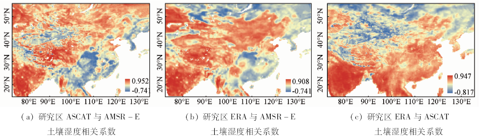
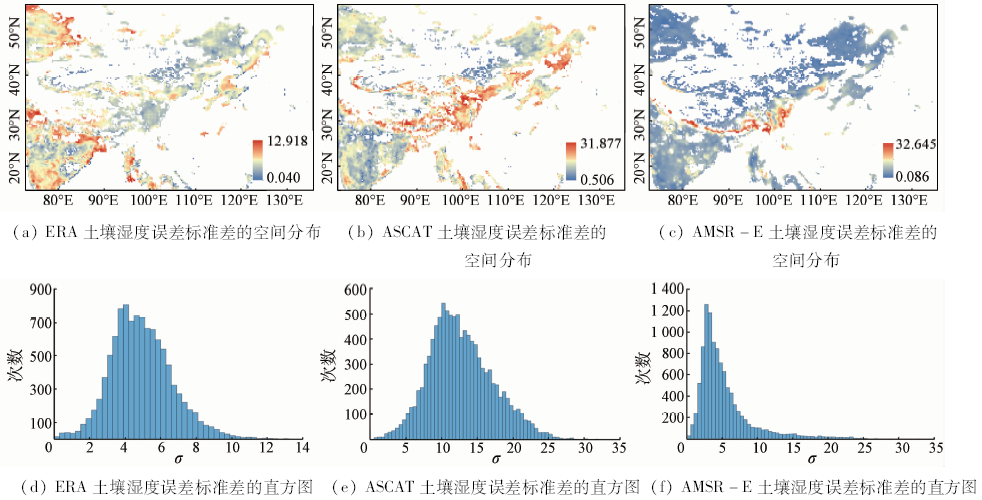
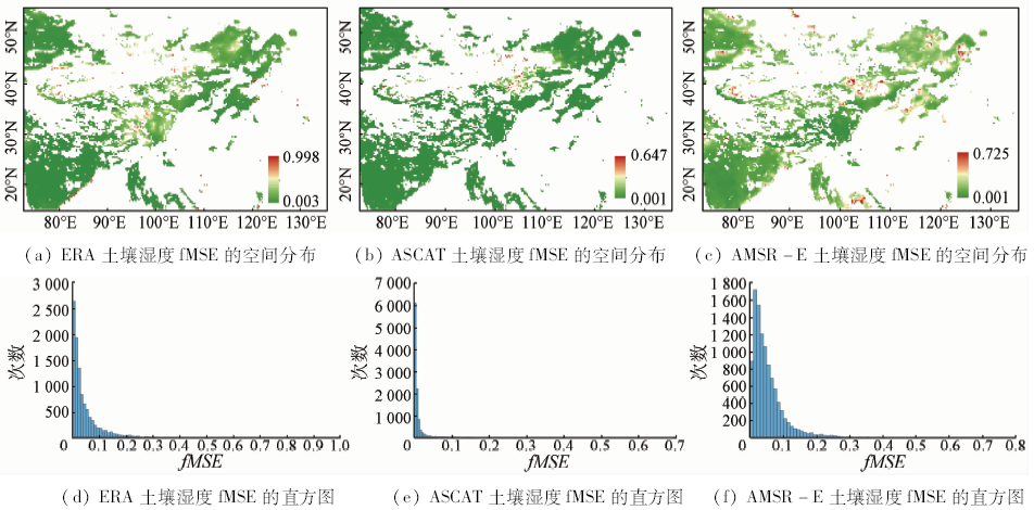
As one of the important driving parameters in hydrologic cycle, soil moisture has remarkable effect on weather variations. The development of remote sensing technology makes large-area and dynamic soil moisture observation possible, but the accurate estimation of error in remote sensing soil moisture data remains to be further studied. Based on TC method, the authors used ERA-Interim reanalysis soil moisture data and soil moisture derived from ASCAT and AMSR-E in the study area (15°N~55°N,73°E~135°E) to estimate error variance and SNR (Signal Noise Ratio) of these three soil moisture data, and also employed MODIS land cover data to analyze the error characteristics of these three soil moisture data. Study results are as follows: vegetation cover has an influence on TC method to estimate error variance and SNR of remote sensing soil moisture data; From the perspective of error variance estimation, ERA soil moisture has the highest precision, AMSR-E possesses the second place, and ASCAT is the lowest; From the perspective of SNR, ASCAT soil moisture has the highest SNR, ERA’s SNR is higher than AMSR-E and lower than ASCAT, and AMSR-E has the lowest SNR. Mostly, TC result is distributed in grasslands, croplands and barren or sparsely vegetated area through analyzing TC result related to MODIS land cover data, and TC result corresponds to objective reality.
吴凯, 舒红, 聂磊, 焦振航. 基于Triple Collocation方法的土壤湿度误差分析[J]. 国土资源遥感, 2018, 30(3): 68-75.
Kai WU, Hong SHU, Lei NIE, Zhenhang JIAO. Error analysis of soil moisture based on Triple Collocation method. Remote Sensing for Land & Resources, 2018, 30(3): 68-75.
Scipal K, Dorigo W,de Jeu R.Triple collocation:A new tool to determine the error structure of global soil moisture products [C]// Proceedings of 2010 IEEE International Geoscience and Remote Sensing Symposium.Honolulu:IEEE, 2010: 4426-4429.
[2]
Naeimi V, Scipal K, Bartalis Z , et al. An improved soil moisture retrieval algorithm for ERS and METOP scatterometer observations[J]. IEEE Transactions on Geoscience and Remote Sensing, 2009,47(7):1999-2013.
doi: 10.1109/TGRS.2008.2011617
[3]
Parinussa R M , Meesters A G C A,Liu Y Y,et al.Error estimates for near-real-time satellite soil moisture as derived from the land parameter retrieval model[J]. IEEE Geoscience and Remote Sensing Letters, 2011,8(4):779-783.
doi: 10.1109/LGRS.2011.2114872
[4]
Stoffelen A . Toward the true near-surface wind speed:Error modeling and calibration using triple collocation[J]. Journal of Geophysical Research, 1998,103(C4):7755-7766.
doi: 10.1029/97JC03180
[5]
Scipal K, Holmes T,de Jeu R,et al.A possible solution for the problem of estimating the error structure of global soil moisture data sets[J]. Geophysical Research Letters, 2008,35(24):101-106.
[6]
Leroux D J, Kerr Y H, Richaume P, et al. Estimating SMOS error structure using triple collocation [C]// Proceedings of 2011 IEEE International Geoscience and Remote Sensing Symposium.Vancouver:IEEE, 2011: 24-27.
[7]
Yilmaz M T, Crow T W . Evaluation of assumptions in soil moisture triple collocation analysis[J]. Journal of Hydrometeorology, 2014,15(3):1293-1302.
doi: 10.1175/JHM-D-13-0158.1
[8]
Dorigo W A, Scipal K, Parinussa R M , et al. Error characterisation of global active and passive microwave soil moisture data sets[J]. Hydrology and Earth System Sciences Discussions, 2010,14(12):2605-2616.
doi: 10.5194/hess-14-2605-2010
[9]
Renzullo L J, van Dijk A I J M, Perraud J M , et al. Continental satellite soil moisture data assimilation improves root-zone moisture analysis for water resources assessment[J]. Journal of Hydrology, 2014,519:2747-2762.
doi: 10.1016/j.jhydrol.2014.08.008
[10]
Gruber A, Su C H, Zwieback S , et al. Recent advances in(soil moisture) triple collocation analysis[J]. International Journal of Applied Earth Observation and Geoinformation, 2016,45:200-211.
doi: 10.1016/j.jag.2015.09.002
[11]
Yilmaz M T, Crow W T . The optimality of potential rescaling approaches in land data assimilation[J]. Journal of Hydrometeorology, 2013,14(2):650-660.
doi: 10.1175/JHM-D-12-052.1
[12]
Brocca L, Melone F, Moramarco T , et al. Chapter 17: Scaling and Filtering Approaches for the use of Satellite Soil Moisture Observations[M] // Remote Sensing of Energy Fluxes and Soil Moisture Content. England & Wales:CRC Press Taylor & Francis Group, 2013: 415-427.
[13]
Naeimi V, Bartalis Z, Wagner W . ASCAT soil moisture:An assessment of the data quality and consistency with the ERS scatterometer heritage[J]. Journal of Hydrometeorology, 2009,10(2):555-563.
doi: 10.1175/2008JHM1051.1
[14]
Wagner W, Hahn S, Kidd R , et al. The ASCAT soil moisture product:A review of its specifications,validation results, and emerging applications[J]. Meteorologische Zeitschrift, 2013,22(1):5-33.
doi: 10.1127/0941-2948/2013/0399
[15]
Owe M, de Jeu R, Holmes T . Multisensor historical climatology of satellite-derived global land surface moisture[J]. Journal of Geophysical Research, 2008,113(F1):196-199.
doi: 10.1029/2007JF000769
[16]
Berrisford P, Dee D, Poli P , et al. The ERA-interim archive:Version 2.0[J]. Nihon Seirigaku Zasshi Journal of the Physiological Society of Japan, 1969,31(10).
[17]
Brocca L, Hasenauer S, Lacava T , et al. Soil moisture estimation through ASCAT and AMSR-E sensors:An intercomparison and validation study across Europe[J]. Remote Sensing of Environment, 2011,115(12):3390-3408.
doi: 10.1016/j.rse.2011.08.003
[18]
Albergel C, Rüdiger C, Pellarin T , et al. From near-surface to root-zone soil moisture using an exponential filter:An assessment of the method based on in-situ observations and model simulations[J]. Hydrology and Earth System Sciences, 2008,12(6):1323-1337.
doi: 10.5194/hess-12-1323-2008
[19]
Friedl M A, Sulla-menashe D,Tan B,et al.MODIS collection 5 global land cover:Algorithm refinements and characterization of new datasets[J]. Remote Sensing of Environment, 2010,114(1):168-182.
doi: 10.1016/j.rse.2009.08.016
 2018, Vol. 30