1. Department of Geographical Science, Minjiang University, Fuzhou 350108, China 2. Fuzhou Meterorological Service, Fuzhou 350008, China 3. Minjiang University, Fuzhou 350108, China
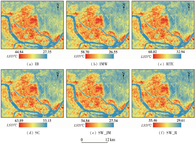
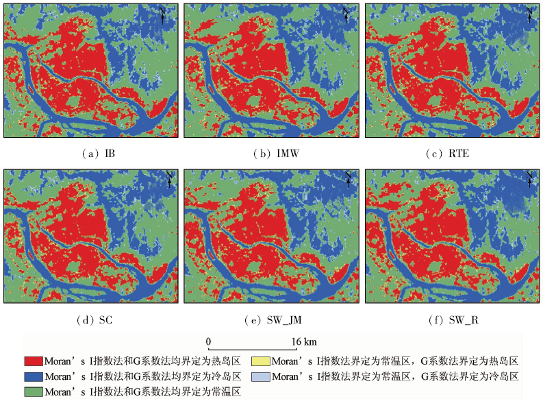
In this paper, two spatial autocorrelation indices were used to delimit urban heat island in Fuzhou City in a statistical sense. The effectiveness and limitation of the two indices were then analyzed so as to find effective methods for quantitative study of urban heat island. At first, land surface temperature (LST) was retrieved on the basis of Landsat8 thermal infrared data of Fuzhou City by applying 6 methods that are frequently used. Then Local Moran’s I Index and Getis-Ord local G were used to delimit urban heat island in the study area. At last the different delimitation outcomes were compared with each other and were then compared with the outcomes obtained by other methods, including equal interval method, mean standard deviation method and regional average classification method. The findings are as follows: ① Both Local Moran’s I index and Getis-Ord local G accurately delimit urban heat island. By comparison, Getis-Ord local G is more accurate in heat island delimitation and is less dependent on methods of LST retrieval. It is more comparable with other heat island delimitation methods; ② The method applying Getis-Ord local G takes into account both surface temperature and spatial correlation of temperature, which makes the delimitation outcome statistically meaningful. With its threshold value free of human factors, the method is therefore more objective and more applicable in the quantitative study of urban heat island.
Howard L .Climate of London deduced from meteorological observation[J].Harvey and Darton, 1833,1(3):1-24.
[2]
Zhou D C, Zhang L X, Hao L , et al. Spatiotemporal trends of urban heat island effect along the urban development intensity gradient in China[J]. Science of the Total Environment, 2016,544:617-626.
doi: 10.1016/j.scitotenv.2015.11.168
[3]
Liu K, Su H B, Li X K , et al. Quantifying spatial-temporal pattern of urban heat island in Beijing:An improved assessment using land surface temperature (LST) time series observations from Landsat,MODIS,and Chinese new satellite GaoFen-1[J]. IEEE Journal of Selected Topics in Applied Earth Observations and Remote Sensing, 2016,9(5):2028-2042.
doi: 10.1109/JSTARS.2015.2513598
[4]
Li C F, Shen D, Dong J S , et al. Monitoring of urban heat island in Shanghai,China,from 1981 to 2010 with satellite data[J]. Arabian Journal of Geosciences, 2014,7(10):3961-3971.
doi: 10.1007/s12517-013-1053-8
[5]
Wang J, Huang B, Fu D J , et al. Spatiotemporal variation in surface urban heat island intensity and associated determinants across major Chinese cities[J]. Remote Sensing, 2015,7(4):3670-3689.
doi: 10.3390/rs70403670
Chen J, Yang X Y . A study of remote sensing monitoring of urban thermal environment based on ASTER data[J]. Remote Sensing for Land and Resources, 2011,23(3):100-105.doi: 10.6046/gtzyyg.2011.03.18.
Chen S L, Wang T X . Comparison analyses of equal interval method and mean-standard deviation method used to delimitate urban heat island[J]. Journal of Geo-information Science, 2009,11(2):145-150.
Zhang W, Jiang J G, Zhu Y B . Spatial-temporal evolution of urban thermal environment based on spatial statistical features[J]. Chinese Journal of Applied Ecology, 2015,26(6):1840-1846.
Xu H Q, Chen B Q . An image processing technique for the study of urban heat island changes using different seasonal remote sensing data[J]. Remote Sensing Technology and Application, 2003,18(3):129-133.
Xu H Q . Analysis on urban heat island effect based on the dynamics of urban surface biophysical descriptors[J]. Acta Ecologica Sinica, 2011,31(14):3890-3901.
Zhang H, Xu H Q, Li L , et al. Analysis of the relationship between urban heat island effect and urban expansion in Chengdu,China[J]. Journal of Geo-information Science, 2014,16(1):70-78.
Qiao Z, Tian G J . Spatiotemporal diversity and regionalization of the urban thermal environment in Beijing[J]. Journal of Remote Sensing, 2014,18(3):715-734.
Bai Y, Meng H, Wang M , et al. Spatial and temporal changes of urban thermal landscape pattern in Shanghai[J]. Environmental Science and Technology, 2013,36(3):196-201.
Liu S, Li Q, Zhu Y J . Study on seasonal variation of urban heat island with HJ-1B satellite imagery:A case study of Beijing[J]. Scientia Geographica Sinica, 2014,34(1):84-88.
Wang L, Meng Q Y, Wu J , et al. Monitoring and analyzing spatio-temporal changes of heat island intensity in Beijing main urban construction area from 2005 to 2014[J]. Journal of Geo-information Science, 2015,17(9):1047-1054.
[16]
Stewart I D . A systematic review and scientific critique of methodology in modern urban heat island literature[J]. International Journal of Climatology, 2011,31(2):200-217.
doi: 10.1002/joc.v31.2
Jiang Z L, Pan H, Zhang B Y , et al. Spatiotemporal pattern changes of urban heat island based on spatial autocorrelation[J]. Journal of Anhui Agricultural Science, 2016,44(30):41-45,135.
Wang P L, Zhang J M, Lyu R F . Urban thermal environment pattern with spatial autocorrelation in Lanzhou[J]. Chinese Journal of Ecology, 2014,33(4):1089-1095.
Jiang Z L, Su S L, Jing C W , et al. Spatio-temporal dynamics of soil loss in Anji County, Zhejiang Province using exploratory spatial data analysis[J]. Journal of Zhejiang University(Science Edition), 2011,38(6):708-715.
Zhang S L, Zhang K . Contrast study on Moran and Getis-ord indexes of local spatial autocorrelation indices[J]. Journal of Geodesy and Geodynamics, 2007,27(3):31-34.
Qin Z H, Li W J, Xu B , et al. The estimation of land surface emissivity for Landsat TM6[J]. Remote Sensing for Land and Resources, 2004,16(3):28-32,36.doi: 10.6046/gtzyyg.2004.03.07.
[23]
NASA.Landsat 7 Science Data Users Handbook[EB/OL].( 2016 -08)[2016-12-09].
[24]
Wang F, Qin Z H, Song C Y , et al. An improved mono-window algorithm for land surface temperature retrieval from Landsat 8 thermal infrared sensor Data[J]. Remote Sensing, 2015,7(4):4268-4289.
doi: 10.3390/rs70404268
[25]
Yu X L, Guo X L, Wu Z C . Land surface temperature retrieval from Landsat 8 TIRS-Comparison between radiative transfer equation-based method,split window algorithm and single channel method[J]. Remote Sensing, 2014,6(10):9829-9852.
doi: 10.3390/rs6109829
[26]
Jiménez-Muñoz J C, Sobrino J A . A generalized single-channel method for retrieving land surface temperature from remote sensing data[J]. Journal of Geophysical Research:Atmospheres, 2003,108(D22):4688.
doi: 10.1029/2003JD003480
[27]
Jiménez-Muñoz J C, Cristóbal J, Sobrino J A , et al. Revision of the single-channel algorithm for land surface temperature retrieval from Landsat thermal-infrared data[J]. IEEE Transactions on Geoscience and Remote Sensing, 2009,47(1):339-349.
doi: 10.1109/TGRS.2008.2007125
[28]
Jiménez-Muñoz J C, Sobrino J A, Skoković D , et al. Land surface temperature retrieval methods from Landsat-8 thermal infrared sensor data[J]. IEEE Geoscience and Remote Sensing Letters, 2014,11(10):1840-1843.
doi: 10.1109/LGRS.2014.2312032
[29]
Rozenstein O, Qin Z H, Derimian Y , et al. Derivation of land surface temperature for Landsat-8 TIRS using a split window algorithm[J]. Sensors, 2014,14(4):5768-5780.
doi: 10.3390/s140405768
pmid: 24670716
[30]
Anselin L . Local indicators of spatial association-LISA[J]. Geographical Analysis, 1995,27(2):93-115.
[31]
Ord J K, Getis A . Local spatial autocorrelation statistics:Distributional issues and an application[J]. Geographical Analysis, 1995,27(4):286-306.
Liu Y H, Xu Y M, Ma J J , et al. Quantitative assessment and planning simulation of Beijing urban heat island[J]. Ecology and Environmental Sciences, 2014,23(7):1156-1163.
 2018, Vol. 30
  ), 张宝玉1, 王婷芬1