1. Institute of Marine Science and Technology and the Environment, Dalian Ocean University, Dalian 116023, China 2. The Nearshore Environmental Science and Technology Key Laboratory of Liaoning Province Colleges and Universities, Dalian 116023, China
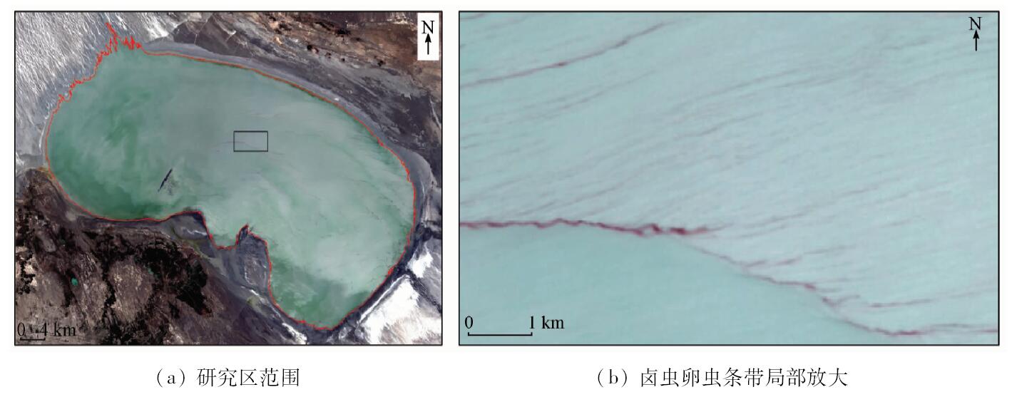
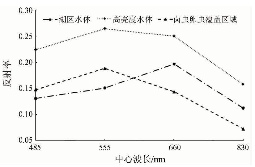
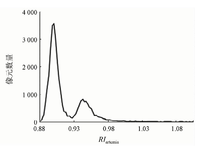
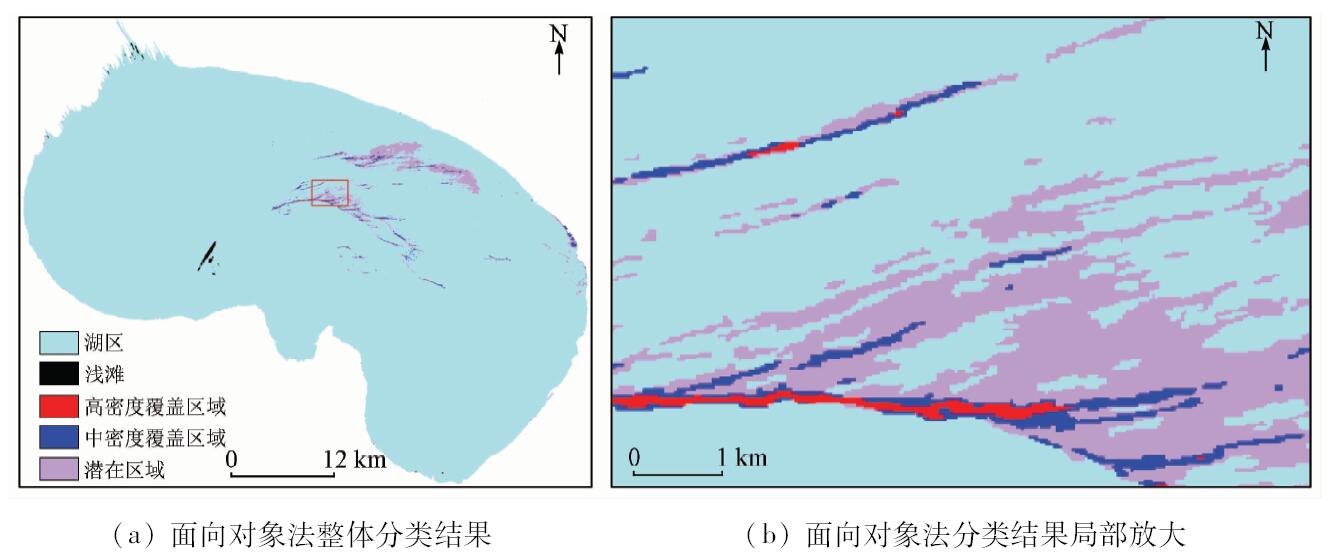
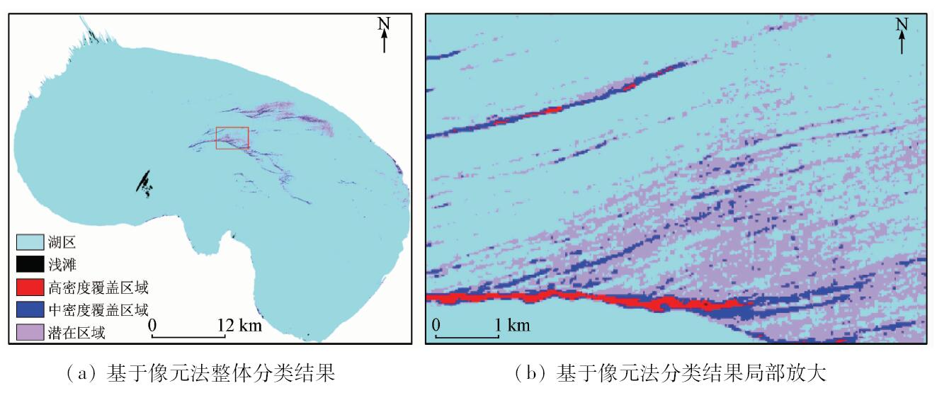
With the Ebinur Lake as the research area and the ZY-3 multi-spectral image as the data source, the authors preprocessed the data by such means as ortho-rectification, radiometric calibration and atmospheric correction. The authors analyzed the spectral characteristics of different water bodies, found interpretation signs for artemia information extraction, and built the oriented-object artemia information extraction model by the spectral, texture and shape information. The classification results were validated using the confusion matrix, with the overall classification accuracy being 91.74% and Kappa coefficient being 0.89. In addition, classification accuracy between object-oriented method and pixel based method was analyzed and compared for the artemia water of different densities. The classification accuracies of object-oriented method for high density, medium density and potential regions were 95.08%, 92.30% and 91.26%, respectively, whereas those of pixel based method were 90.16%, 87.18% and 86.40%, respectively. The results show that the object-oriented method is more effective than the pixel based method. The object-oriented method greatly avoids the phenomenon of “salt and pepper” and can distinguish the artemia densities. The study can provide the effective method for monitoring the distribution and intensity of artemia and has great significance for scientific and reasonable artemia fishing.
Yang C, Wang J L, Li S H , et al. Land degradation dynamic remote sensing monitor of Fuxian Lake Basin[J]. Remote Sensing Technology and Application, 2016,31(2):388-396.
Wang Y, Liu Q G, Feng Q L , et al. Inversion of chlorophyll-a concentration based on satellite remote sensing in Qiandao Lake[J]. Acta Laser Biology Sinica, 2015,24(5):441-447.
Zhang P, Chen X L, Lu J Z , et al. Suspended sediment transport modeling of Poyang Lake in the wet season based on remote sensing data[J]. Geomatics and Information Science of Wuhan University, 2017,42(3):369-376.
Song Y, Song X D, Guo Q H , et al. Remote sensing monitoring and pre-alarming of algal blooms in Taihu Lake[J]. Spectroscopy and Spectral Analysis, 2011,31(3):753-757.
Jia K, Li Q Z, Tian Y C , et al. A review of classification methods of remote sensing imagery[J]. Spectroscopy and Spectral Analysis, 2011,31(10):2618-2623.
Li L, Luo H, Tang X M , et al. Characteristic analysis and quality assessment of ZY-3 multi-spectral image[J]. Remote Sensing for Land and Resources, 2014,26(1):17-24.doi: 10.6046/gtzyyg.2014.01.04.
Li J, Zhao G X, Chang C Y , et al. Land salinization information extraction method based on HSI hyperspectral and TM imagery[J]. Spectroscopy and Spectral Analysis, 2014,34(2):520-525.
Zhang S, Chen J F, Gong J Z . Object-oriented classification based on C5.0 algorithm[J]. Science of Surveying and Mapping, 2016,41(6):117-121,125.
[13]
Gonzalez R C, Woods R E, Eddins S L . Digital Image Processing[M]. 2nd ed.Beijing:Publishing House of Electronics Industry, 2013: 567-642.
[14]
Cheng J H, Bo Y C, Zhu Y X , et al. A novel method for assessing the segmentation quality of high-spatial resolution remote-sensing images[J]. International Journal of Remote Sensing, 2014,35(10):3816-3839.
doi: 10.1080/01431161.2014.919678
[15]
Benz U C, Hofmann P, Willhauck G , et al. Multi-resolution,object-oriented fuzzy analysis of remote sensing data for GIS-ready information[J]. ISPRS Journal of photogrammetry and Remote Sensing, 2004,58(3/4):239-258.
doi: 10.1016/j.isprsjprs.2003.10.002
Gong J Y, Yao H, Shen X . Object-oriented classification of high spatial-resolution remote sensing imagery based on AdaBoost[J]. Geomatics and Information Science of Wuhan University, 2010,35(12):1440-1443,1448.
 2018, Vol. 30
  )
)