Optimal scale selection for multi-scale segmentation based on RMNE method
Ning MAO1,2, Huiping LIU1,2, Xiangping LIU1,2, Yanghua ZHANG1,2
1.Beijing Key Laboratory of Environmental Remote Sensing and Digital Cities, Beijing Normal University, Beijing 100875, China 2.School of Geography, Faculty of Geographical Science, Beijing Normal University, Beijing 100875, China
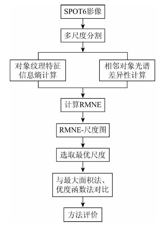
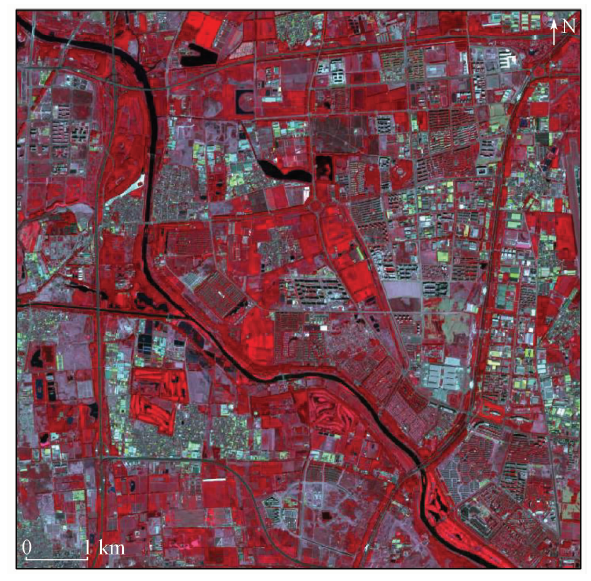
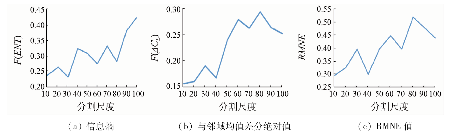
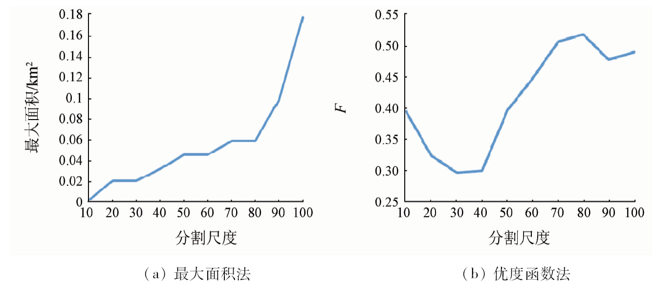
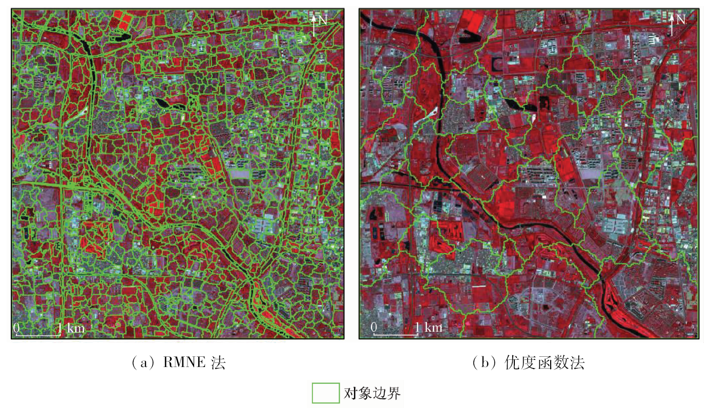
多尺度分割是面向对象地物信息提取技术中的重要方法之一。最优分割尺度的选取是该方法的研究热点。针对现有最优分割尺度选取方法大多仅利用对象光谱特征的局限,本文提出RMNE(the ratio of mean difference to neighbors (Abs) to entropy)方法,利用纹理特征的信息熵和光谱特征与邻域均值差分绝对值进行对象内部同质性和对象之间异质性的衡量,构建评价函数,通过绘制函数曲线选取最优分割尺度。以北京市城市边缘地区6 m空间分辨率的SPOT6多光谱影像为例进行多尺度分割,获得最优分割尺度组合为30,60和80,并与最大面积法和优度函数法选取的最优分割尺度对应的分割结果进行对比。结果表明,RMNE方法的分割结果最好,验证了该方法的有效性和对高空间分辨率影像的适用性; 通过与Google Earth影像对比,发现RMNE方法分割得到的影像对象大小与地物实际大小最为相符。
Multi-scale segmentation is one of the most important methods in object oriented information extraction, and the selection of optimal segmentation scale is a hot topic. Nevertheless, existing optimal segmentation scale selection methods only use spectral characteristics. In view of such a situation, this paper proposes a RMNE method, which uses textural information entropy to measure the heterogeneity between objects, uses spectral characteristics mean difference to neighborhoods to measure the object’s internal homogeneity and construct the evaluation function, and selects the optimal segmentation scales by drawing function curve. Taking 6 m spatial resolution multi-spectral SPOT6 image of the periphery of Beijing City as the multi-scale segmentation experiment example, the authors detected that the optimal scales combination is 30, 60 and 80. Compared with the multi-scale segmentation results whose optimal scales are obtained by the maximum area method and objective function method, it is shown that the effect of RMNE method is the best, which verifies the validity of the RMNE method and the applicability of the high resolution image. A comparison with Google Earth image shows that the image object’s size obtained by RMNE method is most consistent with that of the actual ground object.
Hall O, Hay G J . A multiscale object-specific approach to digital change detection[J]. International Journal of Applied Earth Observation and Geoinformation, 2003,4(4):311-327.
doi: 10.1016/S0303-2434(03)00010-2
[2]
Espindola G M, Camara G, Reis I A , et al. Parameter selection for region-growing image segmentation algorithms using spatial autocorrelation[J]. International Journal of Remote Sensing, 2006,27(14):3035-3040.
doi: 10.1080/01431160600617194
[3]
Woodcock C E, Strahler A H . The factor of scale in remote sensing[J]. Remote Sensing of Environment, 1987,21(3):311-332.
doi: 10.1016/0034-4257(87)90015-0
Zhang J, Zhu G L, Li Y . Scale effect and optimal scale in object-oriented information extraction of high spatial resolution remote sensing image[J]. Science of Surveying and Mapping, 2011,36(2):107-109.
Huang H P, Wu B F . Analysis to the relationship of feature size,objects scales,image resolution[J]. Remote Sensing Technology and Application, 2006,21(3):243-248.
Dian Y Y, Fang S H, Yao C H . Change detection for high-resolution images using multilevel segment method[J]. Journal of Remote Sensing, 2016,20(1):129-137.
Yuan X H, Luo W, Wang C Y . Optimal scale selection research of high-resolution remote sensing images of rare earth mine in Ganzhou[J].Geomatics and Spatial Information Technology, 2013(9):48-50.
[8]
Liang K, Tjahjadi T . Adaptive scale fixing for multiscale texture segmentation[J]. IEEE Transactions on Image Processing, 2006,15(1):249-256.
doi: 10.1109/TIP.2005.860340
pmid: 16435554
[9]
Coburn C A , Roberts A C B .A multiscale texture analysis procedure for improved forest stand classification[J]. International Journal of Remote Sensing, 2004,25(20):4287-4308.
doi: 10.1080/0143116042000192367
[10]
Kim M, Warner T A, Madden M , et al. Multi-scale GEOBIA with very high spatial resolution digital aerial imagery:Scale,texture and image objects[J]. International Journal of Remote Sensing, 2011,32(10):2825-2850.
doi: 10.1080/01431161003745608
Lin X, Peng D L, Huang G S , et al. Object-oriented classification with multi scale texture feature based on remote sensing image[J]. Engineering of Surveying and Mapping, 2016,25(7):22-27.
[12]
Wang J L, Han Y, Zhao S S , et al. A new multi-scale analytic algorithm for edge extraction of strawberry leaf images in natural light[J]. International Journal of Agriculturaland Biological Engineering, 2016,9(1):99-108.
Lin X J, Peng D L, Wang H B . Classification of high-resolution image based on optimal scale and rule[J]. Engineering of Surveying and Mapping, 2017,26(9):14-22.
Yang H P, Ming D P . Optimal scales based segmentation of high spatial resolution remote sensing data[J]. Journal of Geo-Information Science, 2016,18(5):632-638.
[15]
Malik J, Belongie S, Leung T , et al. Contour and texture analysis for image segmentation[J]. International Journal of Computer Vision, 2001,43(1):7-27.
doi: 10.1023/A:1011174803800
 2019, Vol. 31