Please wait a minute...
 
国土资源遥感  2018, Vol. 30 Issue (4): 218-224    DOI: 10.6046/gtzyyg.2018.04.33
     本期目录 | 过刊浏览 | 高级检索 |
基于MapGIS和ArcGIS的遥感解译成果图件数据库设计与实现
随欣欣, 眭素文
中国国土资源航空物探遥感中心,北京 100083
Design and implementation of remote sensing interpretation map database based on MapGIS and ArcGIS
Xinxin SUI, Suwen SUI
China Aero Geophysical Survey and Remote Sensing Center for Land and Resources, Beijing 100083, China
全文: PDF(5098 KB)   HTML  
输出: BibTeX | EndNote (RIS)      
摘要 

遥感解译成果图件来源复杂、格式繁多,通用的影像数据系统存在无法同时进行图件的符号化显示和图层的空间数据管理等问题,导致大量经过野外验证的遥感解译成果图件闲置。本文充分利用MapGIS和ArcGIS平台在图件数据和空间数据管理方面的优势,结合用户对遥感解译成果图件服务的需求,提出了遥感解译成果图件资料和空间要素图层的一体化存储管理方式,开发了遥感解译成果图件数据库及数据库管理系统,并根据成果图件的特点设计了灵活的数据入库工具,实现了不同格式成果图件资料的信息化及一体化管理,有效提高了遥感解译成果图件的服务能力和成果价值。

服务
把本文推荐给朋友
加入引用管理器
E-mail Alert
RSS
作者相关文章
随欣欣
眭素文
关键词 遥感解译图件MapGISArcGIS数据库    
Abstract

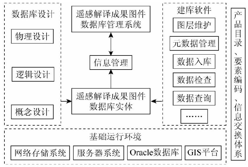
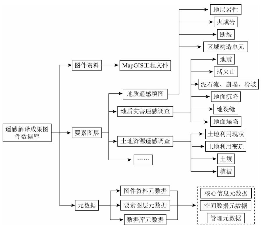
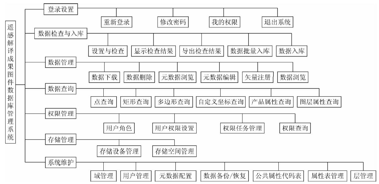
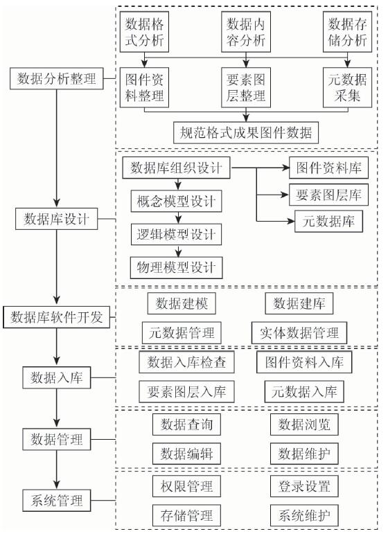
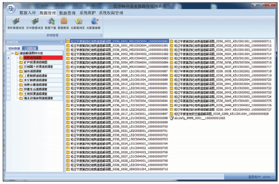
Remote sensing interpretation map has characteristics of complex sources and various formats, while the traditional image database system cannot display map symbols and manage spatial data simultaneously, which makes a large number of maps unused after field confirmation. Taking advantage of the MapGIS and ArcGIS platform in management of the map data and spatial data and considering the needs of users for map service, the method puts forward integrated storage and management of map data and element layers and develops the remote sensing interpretation map database system. According to the characteristics of maps, the flexible tool of importing data is designed. This system realizes the information and integration management of the multiple format maps, which greatly improves the service capability and research value of the maps.

Key wordsremote sensing interpretation    map    MapGIS    ArcGIS    database
收稿日期: 2017-05-16      出版日期: 2018-12-07
:  TP311  
基金资助:中国地质调查局项目“航空物探遥感数据集成与服务系统建设”资助(1212011120425)
作者简介: 随欣欣(1983-),女,博士,高级工程师,主要从事遥感信息化研究。Email: sxx5666@163.com
引用本文:   
随欣欣, 眭素文. 基于MapGIS和ArcGIS的遥感解译成果图件数据库设计与实现[J]. 国土资源遥感, 2018, 30(4): 218-224.
Xinxin SUI, Suwen SUI. Design and implementation of remote sensing interpretation map database based on MapGIS and ArcGIS. Remote Sensing for Land & Resources, 2018, 30(4): 218-224.
链接本文:  
https://www.gtzyyg.com/CN/10.6046/gtzyyg.2018.04.33      或      https://www.gtzyyg.com/CN/Y2018/V30/I4/218
Fig.1  系统框架
Fig.2  数据库构成
Fig.3  数据库管理系统构成
Fig.4  数据库系统建设流程
Fig.5  系统主界面
Fig.6  资料数据和空间数据展示界面
[1] 王润生, 熊盛青, 聂洪峰 , 等. 遥感地质勘查技术与应用研究[J]. 地质学报, 2011,85(11):1699-1743.
Wang R S, Xiong S Q, Nie H F , et al. Remote sensing technology and its application in geological exploration[J]. Acta Geologica Sinica, 2011,85(11):1699-1743.
[2] 其和日格, 韩志军 . 地质调查信息化建设[J].国土资源信息化, 2003(1):12-16.
Qihe R G, Han Z J . Construction of geology survey infomatization[J].Land and Resources Infomatization, 2003(1):12-16.
[3] 茹湘兰, 王黔驹, 连健 , 等. 关于推进原始地质资料社会化服务的对策建议[J]. 中国矿业, 2013,22(7):49-52.
doi: 10.3969/j.issn.1004-4051.2013.07.014
Ru X L, Wang Q J, Lian J , et al. Proposals in the social service of original geological data[J]. China Mining Magazine, 2013,22(7):49-52.
[4] 郭豫宾, 何政伟, 许辉熙 . 应用MapGIS和ArcGIS构建矿产规划数据库[J]. 测绘与空间地理信息, 2009,32(5):127-129.
Guo Y B, He Z W, Xu H X . Using MapGIS and ArcGIS construct inerals plan database[J]. Geomatics and Spatial Information Technology, 2009,32(5):127-129.
[5] 张文, 孟令奎, 周扬 , 等. 多源水利遥感数据的一体化管理机制研究[J].水利信息化, 2012(4):1-5.
Zhang W, Meng L K, Zhou Y , et al. Study on integrated management mechanism of multi-resources remote sensing data for water conservancy[J].Water Resources Informatization, 2012(4):1-5.
[6] 叶水盛, 袁鑫 . 地学综合信息图库管理系统的进一步开发应用[J]. 吉林大学学报(地球科学版), 2010,40(3):726-732.
doi: 10.3969/j.issn.1671-5888.2010.03.036
Ye S S, Yuan X . Further development and application of geosciences synthetic information maps database management system[J]. Journal of Jilin University(Earth Science Edition), 2010,40(3):726-732.
[7] 王建敏, 孟凡帅, 孙琳 . 地理信息产品综合浏览系统的建立[J]. 辽宁工程技术大学学报(自然科学版), 2010,30(3):378-381.
doi: 10.1018.003
Wang J M, Meng F S, Sun L . Development of integrated browsing system for GIS products[J]. Journal of Liaoning Technical University (Natural Science), 2010,30(3):378-381.
[8] 王文志, 白云鹏, 王磊 , 等. 地质调查遥感数据服务系统设计与实现[J]. 地质力学学报, 2012,18(3):296-305.
doi: 10.3969/j.issn.1006-6616.2012.03.012
Wang W Z, Bai Y P, Wang L , et al. Design and implementation of remote sensing data service system for geological survey[J]. Journal of Geomechanics, 2012,18(3):296-305.
[1] 刘志中, 宋英旭, 叶润青. 渝东北2014年“8·31”暴雨诱发滑坡遥感解译与分析[J]. 自然资源遥感, 2021, 33(4): 192-199.
[2] 张珂, 刘建忠, 程维明. 月球哥白尼纪次级坑的形态特征及其空间分布[J]. 国土资源遥感, 2019, 31(1): 255-263.
[3] 谢小平, 白毛伟, 陈芝聪, 柳伟波, 席书娜. 龙门山断裂带北东段活动断裂的遥感影像解译及构造活动性分析[J]. 国土资源遥感, 2019, 31(1): 237-246.
[4] 随欣欣, 眭素文, 刘锟. 面向遥感业务应用的解译成果数据管理系统研究和构建[J]. 国土资源遥感, 2018, 30(3): 238-243.
[5] 王瑞军, 闫柏琨, 李名松, 董双发, 孙永彬, 汪冰. 甘肃红山地区重要控矿地质单元GF-1数据遥感解译与应用[J]. 国土资源遥感, 2018, 30(2): 162-170.
[6] 王彦佐, 周伟, 冯磊. 内存数据库在ZY1-02C海量数据空间检索中的应用[J]. 国土资源遥感, 2018, 30(1): 238-242.
[7] 张策, 揭文辉, 付丽华, 魏本赞. 新疆新源县滑坡灾害遥感影像特征及分布规律[J]. 国土资源遥感, 2017, 29(s1): 81-84.
[8] 李海鹰. 国产高分辨率遥感数据在环境地质调查中的应用[J]. 国土资源遥感, 2017, 29(s1): 46-51.
[9] 王瑞军, 董双发, 孙永彬, 李婧玥. 基于高分一号卫星数据新疆索拉克地区控矿地质单元遥感解译与应用[J]. 国土资源遥感, 2017, 29(s1): 137-143.
[10] 刁明光, 瞿翟, 薛涛, 李建存, 张永强. 基于AE插件式矿山遥感监测成果数据质量检查系统[J]. 国土资源遥感, 2017, 29(4): 219-224.
[11] 李晓民, 张焜, 李冬玲, 李得林, 李宗仁, 张兴. 青藏高原札达地区多年冻土遥感技术圈定方法与应用[J]. 国土资源遥感, 2017, 29(1): 57-64.
[12] 李晓民, 燕云鹏, 刘刚, 李冬玲, 张兴, 庄永成. ZY-1 02C星数据在西藏札达地区水文地质调查中的应用[J]. 国土资源遥感, 2016, 28(4): 141-148.
[13] 曹昌磊, 赵雪莲, 梅红波. MapGIS向shapefile数据格式转换插件开发及其应用[J]. 国土资源遥感, 2016, 28(2): 193-197.
[14] 高孟绪, 王卷乐, 柏中强, 祝俊祥. 基于RapidEye影像的农村居民地遥感监测——以江西省泰和县为例[J]. 国土资源遥感, 2016, 28(1): 130-135.
[15] 宿渊源, 张景发, 何仲太, 姜文亮, 蒋洪波, 李强. 资源卫星三号DEM数据在活动构造定量研究中的应用评价[J]. 国土资源遥感, 2015, 27(4): 122-130.
Viewed
Full text


Abstract

Cited

  Shared   
  Discussed   
京ICP备05055290号-2
版权所有 © 2015 《自然资源遥感》编辑部
地址:北京学院路31号中国国土资源航空物探遥感中心 邮编:100083
电话:010-62060291/62060292 E-mail:zrzyyg@163.com
本系统由北京玛格泰克科技发展有限公司设计开发