Please wait a minute...
 
国土资源遥感  2019, Vol. 31 Issue (3): 104-110    DOI: 10.6046/gtzyyg.2019.03.14
  技术方法 本期目录 | 过刊浏览 | 高级检索 |
GF-4卫星影像几何定位精度分析
韩杰1, 陶醉2(), 李慧娜3, 苗宝亮4, 石宏斌1, 刘其悦2
1. 许昌学院城乡规划与园林学院,许昌 461000
2. 中国科学院遥感与数字地球研究所,北京 100094
3. 许昌学院电气(机电)工程学院,许昌 461000
4. 中国人民解放军96608部队,洛阳 471000
Geo-positioning accuracy analysis of GF-4 satellite imagery
Jie HAN1, Zui TAO2(), Huina LI3, Baoliang MIAO4, Hongbin SHI1, Qiyue LIU2
1. School of Urban and Rural Planning and Landscape Architecture, Xuchang University, Xuchang 461000, China
2. Institute of Remote Sensing and Digital Earth, Chinese Academy of Sciences, Beijing 100094, China
3. School of Electric (Electromechanical) Engineering, Xuchang University, Xuchang 461000,China
4. 96608 Troops of PLA, Luoyang 471000, China
全文: PDF(4269 KB)   HTML  
输出: BibTeX | EndNote (RIS)      
摘要 

几何定位精度是衡量卫星影像几何质量的一个重要参数。针对高分四号(GF-4)卫星静止轨道面阵成像特点,以Google Earth为参考基准,对在轨测试前后GF-4卫星多光谱相机影像几何定位精度进行评价。重点分析了影像几何定位精度与太阳方位角/高度角和卫星方位角/天顶角/姿态角之间的关系,同时探讨了卫星姿态角/成像时间对相机姿态角误差补偿参数的影响。研究结果可为进一步优化该类型卫星影像成像模型,实现高精度几何定位提供参考依据。

服务
把本文推荐给朋友
加入引用管理器
E-mail Alert
RSS
作者相关文章
韩杰
陶醉
李慧娜
苗宝亮
石宏斌
刘其悦
关键词 GF-4几何定位精度误差分析    
Abstract

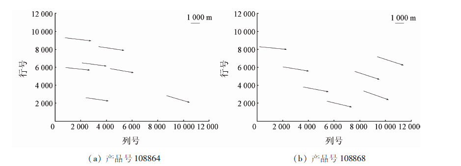
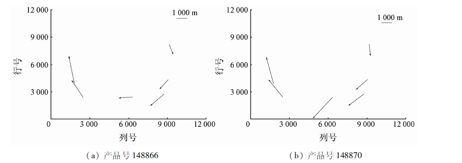
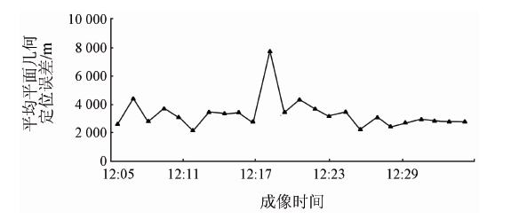
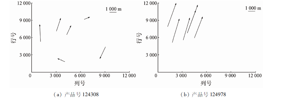
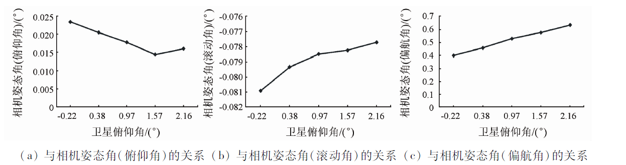
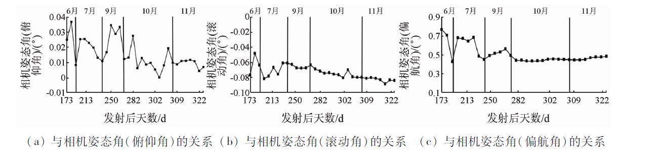
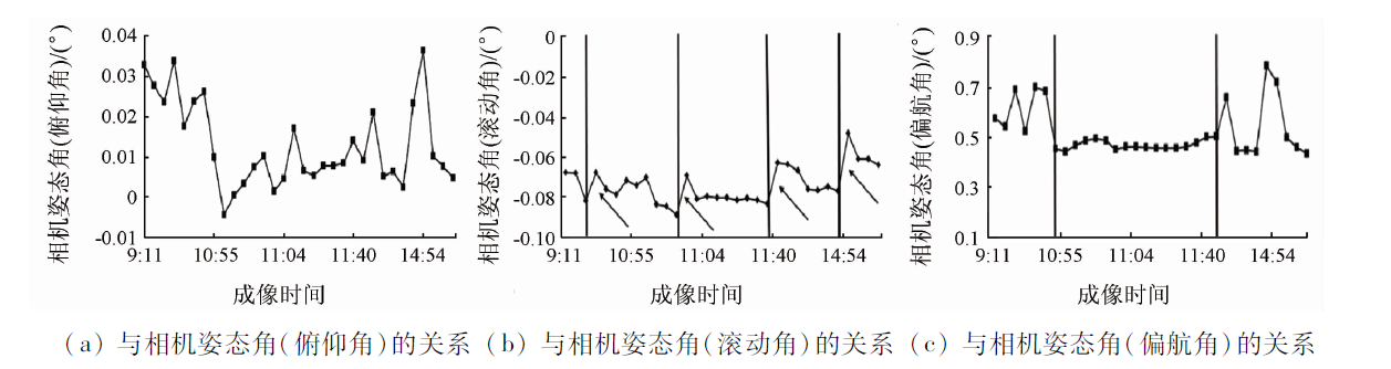
The geo-positioning accuracy is an important parameter in evaluating the geometric quality of the satellite imagery. In this paper, integrating the stationary orbit and area-array image characteristics of GF-4 satellite and taking Google Earth images as geometric references, the authors analyzed the geo-positioning accuracies of multispectral camera images during and after the commissioning phase period. This study was concentrated on the relationships between the image geo-positioning accuracy and the sun azimuth angle, the sun altitude angle, the satellite azimuth angle, the satellite zenith angle, and the satellite attitude angle. Meanwhile, the influence of satellite attitude angle and imaging time on the compensation of camera’s attitude constant angle errors was discussed. The results can be used to improve the imaging model and hence are useful for the high accuracy geo-positioning of this type satellite imagery.

Key wordsGF-4    geo-positioning accuracy    errors analysis
收稿日期: 2018-05-22      出版日期: 2019-08-30
:  TP79  
基金资助:河南省高等学校重点科研项目“高轨静止卫星大面阵相机几何定标及误差分析研究”国家自然科学基金项目“(19A420009);河南省科技攻关项目“激光点云的CSG-BRep拓扑关系构建方法研究”(182102310924);高分辨率光学遥感器辐射定标与归一化技术研究”(41671345);广西创新驱动发展专项(科技重大专项)项目“近海岸双频激光LiDAR探测仪产品开发与应用示范”(2018AA13005);国家民用空间基础设施项目“陆地观测卫星共性应用支撑平台”共同资助
通讯作者: 陶醉
作者简介: 韩 杰(1987-),男,讲师,主要从事高分辨率卫星传感器定标和真实性检验研究。Email: hanjie@radi.ac.cn.。
引用本文:   
韩杰, 陶醉, 李慧娜, 苗宝亮, 石宏斌, 刘其悦. GF-4卫星影像几何定位精度分析[J]. 国土资源遥感, 2019, 31(3): 104-110.
Jie HAN, Zui TAO, Huina LI, Baoliang MIAO, Hongbin SHI, Qiyue LIU. Geo-positioning accuracy analysis of GF-4 satellite imagery. Remote Sensing for Land & Resources, 2019, 31(3): 104-110.
链接本文:  
https://www.gtzyyg.com/CN/10.6046/gtzyyg.2019.03.14      或      https://www.gtzyyg.com/CN/Y2019/V31/I3/104
Fig.1  在轨测试期间影像几何定位误差分布
影像产品号 平均误差 标准差
N方向 E方向 平面 N方向 E方向 平面
108873 -5 351.37 22 388.58 23 080.14 1 950.32 1 206.49 1 408.64
108872 -5 107.89 20 235.27 20 934.30 1 664.62 1 151.56 980.20
108864 -3 068.25 19 378.54 19 650.49 1 093.16 978.52 867.46
108868 -4 837.00 20 493.51 21 124.21 1 805.51 854.04 813.64
Tab.1  在轨测试期间的影像几何定位误差
Fig.2  凝视成像影像几何定位误差分布
Fig.3  凝视成像影像平均平面几何定位误差
Fig.4  长时间序列影像几何定位误差分布
Fig.5  长时间序列影像平均平面几何定位误差
Fig.6  几何定位误差与太阳/卫星观测角度的关系
Fig.7  影像平均平面几何定位误差与卫星姿态角的关系
Fig.8  卫星滚动角与相机姿态角误差补偿参数的关系
Fig.9  卫星俯仰角与相机姿态角误差补偿参数的关系
Fig.10  卫星成像时间(按天)与相机姿态角误差补偿参数的关系
Fig.11  卫星成像时间(按小时)与相机姿态角误差补偿参数的关系
[1] 李德仁, 童庆禧, 李荣兴 , 等. 高分辨率对地观测的若干前沿科学问题[J]. 中国科学(地球科学), 2012,42(6):805-813.
Li D R, Tong Q X, Li R X , et al. Current issues in high-resolution earth observation technology[J]. Science China Earth Sciences, 2012,42(6):805-813.
[2] 童旭东 . 中国高分辨率对地观测系统重大专项建设进展[J]. 遥感学报, 2016,20(5):775-780.
Tong X D . Development of China high-resolution earth observation system[J]. Journal of Remote Sensing, 2016,20(5):775-780.
[3] 王殿中, 何红艳 . “高分四号”卫星观测能力与应用前景分析[J]. 航天返回与遥感, 2017,38(1):98-106.
Wang D Z, He H Y . Observation capability and application prospect of GF-4 satellite[J]. Spacecraft Recovery and Remote Sensing, 2017,38(1):98-106.
[4] 吴玮, 秦其明, 范一大 , 等. “高分四号”卫星数据产品减灾服务时效性测试[J]. 航天返回与遥感, 2016,37(4):102-109.
Wu W, Qin Q M, Fan Y D , et al. Timeliness testing of GF-4 satellite data product and disaster reduction application service[J]. Spacecraft Recovery and Remote Sensing, 2016,37(4):102-109.
[5] 由佳, 张怀清, 陈永福 , 等. 基于“高分四号”卫星影像洞庭湖湿地信息提取[J]. 航天返回与遥感, 2016,37(4):116-122.
doi: 10.3969/j.issn.1009-8518.2016.04.016
You J, Zhang H Q, Chen Y F , et al. Comparative study of Dongting Lake wetland information extraction based on GF-4 satellite image[J]. Spacecraft Recovery and Remote Sensing, 2016,37(4):116-122.
[6] 王密, 程宇峰, 常学立 , 等. 高分四号静止轨道卫星高精度在轨几何定标[J]. 测绘学报, 2017,46(1):53-61.
Wang M, Cheng Y F, Chang X L , et al. High accuracy on-orbit geometric calibration of geostationary satellite GF4[J]. Acta Geodaetica et Cartographica Sinica, 2017,46(1):53-61.
[7] 徐文, 龙小祥, 李庆鹏 , 等. “高分四号”卫星影像辐射与几何精度评价[J]. 航天返回与遥感, 2016,37(4):16-25.
doi: 10.3969/j.issn.1009-8518.2016.04.003
Xu W, Long X X, Li Q P , et al. Image radiometric and geometric accuracy evaluation of GF-4 satellite[J]. Spacecraft Recovery and Remote Sensing, 2016,37(4):16-25.
[8] 皮英冬, 杨博, 李欣 . 基于有理多项式模型的GF4卫星区域影像平差处理方法及精度验证[J]. 测绘学报, 2016,45(12):1448-1454.
Pi Y D, Yang B, Li X . Block-adjustment and accuracy validation for GF4 patch-images based on RFM[J]. Acta Geodaetica et Cartographica Sinica, 2016,45(12):1448-1454.
[9] 韩杰, 谢勇 . GF-4卫星影像几何定位仿真分析[J].测绘通报, 2018(4):23-27.
Han J, Xie Y . Analysis of geo-positioning simulation of GF-4 satellite images[J].Bulletin of Surveying and Mapping, 2018(4):23-27.
[10] Zhang Y, Zheng M, Xiong J , et al. On-orbit geometric calibration of ZY-3 three-line array imagery with multistrip data sets[J]. IEEE Transactions on Geoscience and Remote Sensing, 2014,52(1):224-234.
[11] Yousefzadeh M, Mojaradi B . Combined rigorous-generic direct orthorectification procedure for IRS-p6 sensors[J]. ISPRS Journal of Photogrammetry and Remote Sensing, 2012,74(6):122-132.
[12] 韩杰, 谢勇 . GF-1卫星WFV影像几何定位稳定性研究[J].测绘通报, 2018(2):50-54.
Han J, Xie Y . Study on the geo-positioning stability of GF-1 WFV images[J].Bulletin of Surveying Mapping, 2018(2):50-54.
[13] 袁修孝, 余翔 . 高分辨率卫星遥感影像姿态角系统误差检校[J]. 测绘学报, 2012,41(3):385-392.
Yuan X X, Yu X . Calibration of angular systematic errors for high resolution satellite imagery[J]. Acta Geodaetica et Cartographica Sinica, 2012,41(3):385-392.
[14] 韩杰, 谢勇, 吴国玺 , 等. 国产高分辨率卫星影像几何定位研究[J]. 国土资源遥感, 2016,28(4):100-107.doi: 10.6046/gtzyyg.2016.04.16.
doi: 10.6046/gtzyyg.2016.04.16
Han J, Xie Y, Wu G X , et al. Geo-positioning accuracy analysis for domestic high-resolution satellite imagery[J]. Remote Sensing for Land and Resources, 2016,28(4):100-107.doi: 10.6046/gtzyyg.2016.04.16.
[15] 常学立 . 静止轨道高分辨率面阵相机几何处理关键技术研究[D]. 武汉:武汉大学, 2015.
Chang X L . Research on Key Technologies of Geometric Processing for High-Resolution Area-Array Camera of Stationary Orbit Satellite[D]. Wuhan:Wuhan University, 2015.
[1] 熊攀, 朱利, 顾行发, 赵利民, 余涛, 孟庆岩, 李家国, 张峰. 基于HJ-1B星热红外数据的大亚湾海温反演模型及其应用[J]. 国土资源遥感, 2014, 26(1): 132-138.
Viewed
Full text


Abstract

Cited

  Shared   
  Discussed   
京ICP备05055290号-2
版权所有 © 2015 《自然资源遥感》编辑部
地址:北京学院路31号中国国土资源航空物探遥感中心 邮编:100083
电话:010-62060291/62060292 E-mail:zrzyyg@163.com
本系统由北京玛格泰克科技发展有限公司设计开发