Please wait a minute...
 
国土资源遥感  2019, Vol. 31 Issue (3): 216-224    DOI: 10.6046/gtzyyg.2019.03.27
  技术应用 本期目录 | 过刊浏览 | 高级检索 |
基于遥感和航磁数据的迪木那里克铁矿带找矿定位预测
张策, 彭莉红, 张恩, 付丽华, 汪冰
核工业航测遥感中心,石家庄 050002
A study of metallogenic prognosis of the Dimunalike iron ore belt based on remote sensing and aeromagnetic data
Ce ZHANG, Lihong PENG, En ZHANG, Lihua FU, Bing WANG
Airborne Survey and Remote Sensing Center of Nuclear Industry, Shijiazhuang 050002, China
全文: PDF(10525 KB)   HTML  
输出: BibTeX | EndNote (RIS)      
摘要 

新疆维吾尔自治区迪木那里克铁矿带是我国西部重要的铁矿整装勘查区,已发现迪木那里克、玉玲和河肃等多个大、中型沉积变质型铁矿床,找矿潜力巨大。但该区特殊的地质构造和恶劣的自然地理条件,给矿产勘查造成了很大的困难。综合利用WorldView-2高空间分辨率遥感数据和航磁数据,在对区内长沙沟蛇绿构造混杂岩带进行分解的基础上,对典型矿床、重点航磁异常进行剖析,构建集地质—航磁—遥感于一体的沉积变质型铁矿综合找矿模型,精准定位磁铁矿赋矿目的层。结果表明,遥感与航磁方法的结合,可对赋矿岩性、控矿构造和矿化带等成矿信息进行精确定位,有效提高矿产勘查的准确度与效率。

服务
把本文推荐给朋友
加入引用管理器
E-mail Alert
RSS
作者相关文章
张策
彭莉红
张恩
付丽华
汪冰
关键词 WorldView-2航磁数据沉积变质型铁矿找矿模型迪木那里克铁矿带    
Abstract

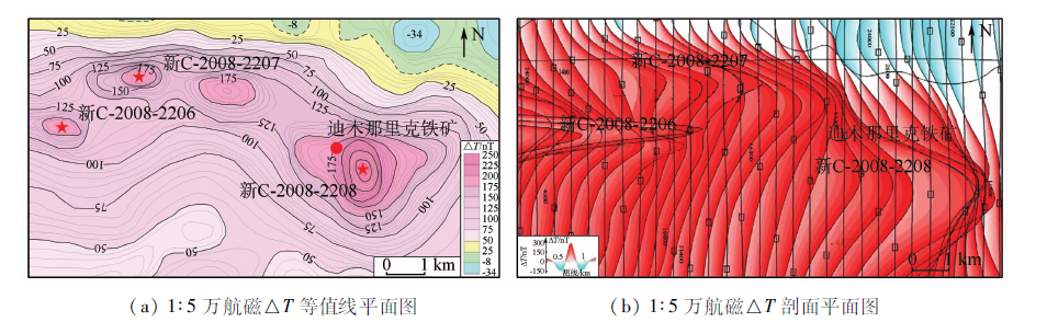
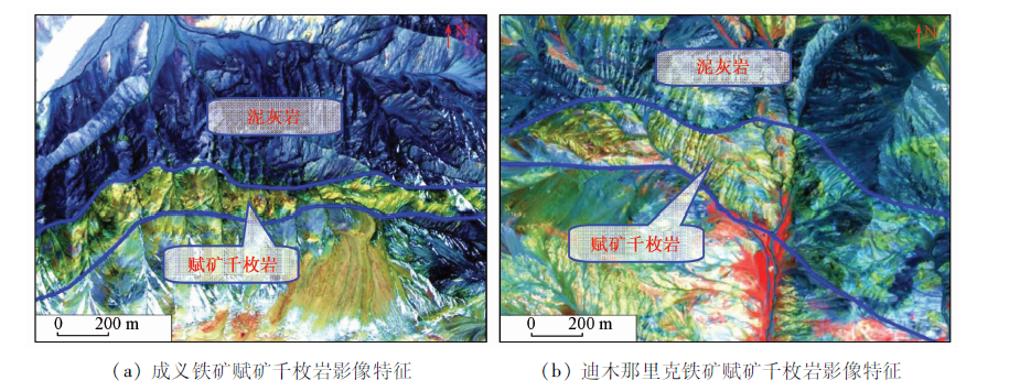
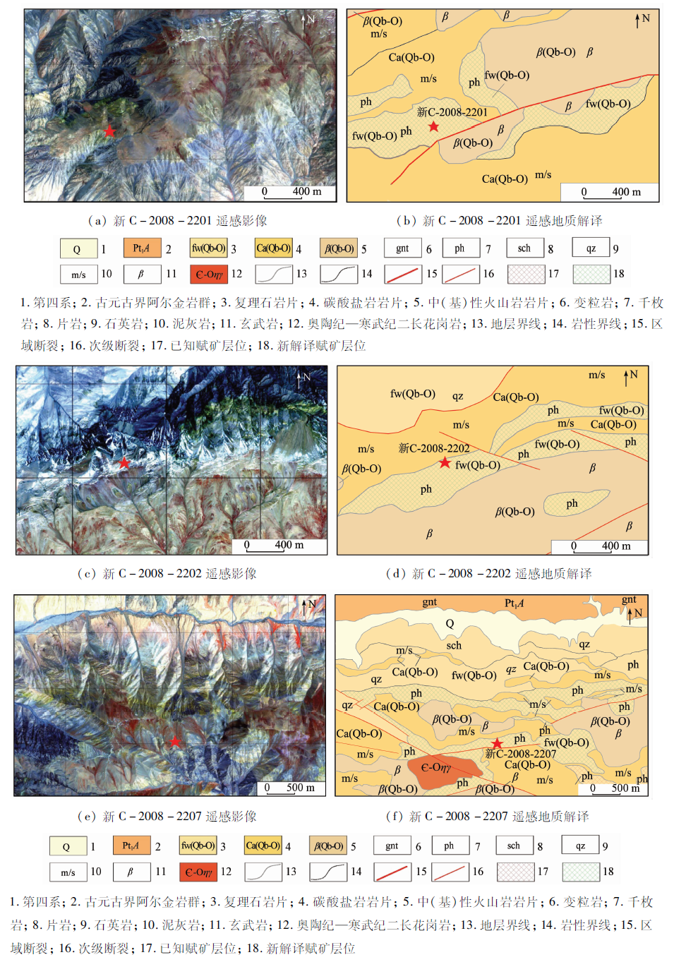
The Dimunalike iron ore belt is an important iron ore exploration area in western China, where the Dimunalike iron ore deposit, the Yuling iron ore deposit and the Hesu iron ore deposit were discovered. Its geological conditions are superior and the potential for prospecting is huge. Nevertheless, due to its special geological structure and harsh natural geographical conditions, there is a great difficulty in the mineral exploration. In this study, the authors made full use of WorldView-2 high spatial resolution remote sensing data and aeromagnetic data and conducted the decomposition of the Changshagou structure-ophiolite belt to analyze remote sensing and aeromagnetic characteristics of typical deposit of the Dimunalike iron deposit. The authors established a comprehensive prospecting model of sedimentary metamorphic iron ore deposit integrated with geology, aeromagnetic and remote sensing. By using this model, the magnetite ore-bearing target can be located precisely. The results show that the combination of remote sensing and aeromagnetic methods can accurately locate the information such as ore-bearing lithology, ore-controlling structure and mineralized zone. This will improve the accuracy and efficiency of geological exploration.

Key wordsWorldView-2    aeromagnetic data    sedimentary-metamorphic iron ore deposit    prospecting model    Dimunalike iron ore belt
收稿日期: 2018-07-06      出版日期: 2019-08-30
:  TP79  
基金资助:中国地质调查局地质调查项目“阿尔金成矿带矿产资源遥感综合调查”资助(12120113044800)
作者简介: 张 策(1985-),男,高级工程师,主要从事遥感地质、矿产地质等工作。Email: 281094506@qq.com.。
引用本文:   
张策, 彭莉红, 张恩, 付丽华, 汪冰. 基于遥感和航磁数据的迪木那里克铁矿带找矿定位预测[J]. 国土资源遥感, 2019, 31(3): 216-224.
Ce ZHANG, Lihong PENG, En ZHANG, Lihua FU, Bing WANG. A study of metallogenic prognosis of the Dimunalike iron ore belt based on remote sensing and aeromagnetic data. Remote Sensing for Land & Resources, 2019, 31(3): 216-224.
链接本文:  
https://www.gtzyyg.com/CN/10.6046/gtzyyg.2019.03.27      或      https://www.gtzyyg.com/CN/Y2019/V31/I3/216
Fig.1  区域地质矿产图
1.第四系; 2.新近系; 3.侏罗系; 4.奥陶系; 5.青白口系; 6.蓟县系; 7.长城系; 8.古元古界阿尔金岩群; 9.新太古界米兰岩群; 10—15为长沙沟蛇绿构造混杂岩单位: 10.碳酸盐岩岩片; 11.复理石岩片; 12.(中)基性火山岩岩片; 13.基性岩墙岩片; 14.超镁铁质—镁铁质岩岩片; 15.新太古—中元古代变质基底岩片; 16.变质侵入岩; 17.白垩纪钾长花岗岩; 18.二叠纪二长花岗岩; 19.志留纪二长花岗岩; 20.奥陶纪二长花岗岩; 21.奥陶纪—寒武纪二长花岗岩; 22.蓟县纪钾长花岗岩; 23.地层界线/角度不整合界线; 24.区域性断裂/实测断裂; 25.推测断裂/遥感解译断裂; 26.大、中、小型铁矿床; 27.铜(镍)矿化点; 28.迪木那里克铁矿带范围
Fig.2  迪木那里克铁矿带航磁△T等值线
Fig.3  迪木那里克铁矿地质矿产图
1.第四系; 2.复理石岩片; 3.碳酸盐岩岩片; 4.千枚岩; 5.石英岩; 6.石英岩夹千枚岩; 7.大理岩; 8.大理岩夹炭质千枚岩; 9.土状粉末状风化氧化破碎带; 10.闪长岩/辉绿辉长岩; 11.已知磁铁矿体; 12.推测断层/实测断层
Fig.4  迪木那里克铁矿航磁异常
Fig.5  赋矿千枚岩层WorldView-2 B8(R),B4(G),B2(B)影像特征
Fig.6  重点航磁异常区航磁△T等值线
Fig.7  重点航磁异常区遥感地质解译
控矿因素 综合找矿模型描述
成矿地质背景 位于阿尔金造山带南缘阿南蛇绿构造混杂岩带内,处于古生代地壳演化拉张阶段所形成的裂陷槽内; 古地理环境位于陆侧的火山岩围限的沉积盆地,古陆及海底火山喷发提供了成矿物质。含矿建造为长沙沟蛇绿构造混杂岩—复理石岩片,为一套浅海—半深海弱还原环境下形成的细碎屑岩—细火山碎屑岩建造(浅变质)
矿源层 含矿地层为构造混杂岩—复理石岩片浅变质碎屑岩,赋矿岩性为绢云(石英)千枚岩及石英岩等,在WorldView-2 B8(R),B4(G),B2(B)假彩色合成影像上,呈黄色、黄褐色色调,局部夹有灰色—蓝灰色纹层,形成典型的平行层状纹理,呈条带状展布,局部呈透镜状,树枝状水系、山脊呈次棱状、浑圆状
导矿、容矿构造 NEE向阿尔金南缘断裂控制复理石岩片的展布,轴向NEE向褶皱内层间断裂及次级NEE向张性断裂为(变质)热液的运移提供了通道
围岩蚀变 经受了氧化作用,低温、低压区域变质作用及轻微的后期热液改造,地表强烈发育的褐铁矿化蚀变破碎带、赭黄色土状黄钾铁矾及围岩绿泥石化、绢云母化为良好的蚀变找矿标志
航磁特征 航磁异常呈近EW向展布的椭圆或长椭圆状高值区,两翼近于对称、圆滑规则的尖峰状正异常,异常强度为150~300 nT
赋矿层位遥感特征 在WorldView-2 B8(R),B4(G),B2(B)假彩色合成影像上,赋矿千枚岩总体呈条带状展布,局部呈透镜状,色调呈黄色、黄褐色,条带状影纹,发育树枝状(局部羽状)水系,山脊半浑圆,影像特征明显,与围岩界线清晰; 上覆含炭泥灰岩呈条带状展布,总体延伸稳定,局部被NNW向线性构造错切,色调较深,呈蓝灰色,条带状粗糙影纹,发育树枝状水系,山脊呈棱角状
野外找矿线索 磁铁矿露头、转石及铁帽是矿化的直接标志
典型矿床 迪木那里克铁矿、成义铁矿、玉玲铁矿
Tab.1  沉积变质型铁矿综合找矿模型
Fig.8  迪木那里克铁矿带磁铁矿赋矿目的层分布解译
1.第四系; 2.上新统狮子沟组; 3.侏罗系大煤沟组; 4.奥陶系祁漫塔格群; 5.复理石岩片; 6.碳酸盐岩岩片; 7.(中)基性火山岩岩片; 8.基性岩墙岩片; 9.超镁铁质、镁铁质岩岩片; 10.青白口系平洼沟组; 11.古元古界阿尔金岩群; 12.二叠纪二长花岗岩; 13.寒武纪—奥陶纪二长花岗岩; 14.阿尔金南缘断裂; 15.区域断裂; 16.次级断裂; 17.推测断裂; 18.地层界线; 19.已知赋矿目的层; 20.新解译赋矿目的层; 21.大、中、小型铁矿床; 22.航磁异常; 23.铁矿带范围; 24.冰雪覆盖物
[1] 贾伟洁, 郭华, 李迁 . ASTER遥感影像与航磁梯度数据综合应用[J]. 吉林大学学报(地球科学版), 2015,45(4):1237-1245.
doi: 10.13278/j.cnki.jjuese.201504303
Jia W J, Guo H, Li Q . Integrated application of ASTER remote sensing image and aeromagnetic gradient data[J]. Journal of Jilin University(Earth Science Edition), 2015,45(4):1237-1245.
[2] 毛德宝, 钟长汀, 牛广华 , 等. 阿尔金成矿带成矿规律与找矿预测[J]. 西北地质, 2006,39(2):114-127.
Mao D B, Zhong C T, Niu G H , et al. Study on metallogenic characteristics and target areas in the Altyn Tagh metallogenic zone[J]. Northwestern Geology, 2006,39(2):114-127.
[3] 伍跃中, 庄道泽, 李洪茂 , 等. 新疆祁漫塔格找矿远景区重要矿产整装勘查[J]. 西北地质, 2010,43(4):25-34.
Wu Y Z, Zhuang D Z, Li H M , et al. The important mineral integrated exploration of Qimantage potential prospecting area in Xinjiang region[J]. Northwestern Geology, 2010,43(4):25-34.
[4] 李文渊 . 祁漫塔格找矿远景区地质组成及勘查潜力[J]. 西北地质, 2010,43(4):1-9.
Li W Y . The geological composition and metallogenetic prospect in the Qimantage prospective region,East Kunlun[J]. Northwestern Geology, 2010,43(4):1-9.
[5] 刘艳宾, 弓小平, 陈斌 , 等. 东昆仑山西段铁矿成矿机制和找矿模型[J]. 地质通报, 2011,30(12):1950-1961.
Liu Y B, Gong X P, Chen B , et al. Metallogenic mechanism and prospecting model of iron deposits in the western segment of East Kunlun Mountain[J]. Geological Bulletin of China, 2011,30(12):1950-1961.
[6] 杨文强, 丁海波, 刘良 , 等. 新疆阿尔金南部迪木那里克铁矿赋矿地层的形成时代及其地质意义[J]. 地质通报, 2012,31(12):2090-2101.
Yang W Q, Ding H B, Liu L , et al. Formation age of ore-bearing strata of the Dimunalike iron deposit in South Altun Mountains and its geological significance[J]. Geological Bulletin of China, 2012,31(12):2090-2101.
[7] 丁海波, 杨晓飞, 张朋 , 等. 新疆东昆仑迪木那里克铁矿床地质特征及找矿方向[J]. 矿床地质, 2013,32(1):195-206.
Ding H B, Yang X F, Zhang P , et al. Geological characteristics and prospecting direction of Dimunalike iron deposit in East Kunlun,Xinjiang[J]. Mineral Deposits, 2013,32(1):195-206.
[8] 丁海波, 张朋, 杨晓飞 , 等. 新疆东昆仑迪木那里克铁矿床及其外围找矿新发现[J]. 矿床地质, 2013,32(1):122-132.
Ding H B, Zhang P, Yang X F , et al. New prospecting discoveries in Dimunalike iron deposit and its peripheralareas in East Kunlun Mountains,Xinjiang[J]. Mineral Deposits, 2013,32(1):122-132.
[9] 杨金中, 陈薇, 王辉 . 西昆仑成矿带黑恰达坂温泉沟群含铁层位的圈定[J]. 国土资源遥感, 2017,29(3):191-195.doi: 10.6046/gtzyyg.2017.03.28.
Yang J Z, Chen W, Wang H . Delineation of iron formation in Wenquangou Group along Heiqia Pass in West Kunlun metallogenic belt[J]. Remote Sensing for Land and Resources, 2017,29(3):191-195.doi: 10.6046/gtzyyg.2017.03.28.
[10] 张微, 金谋顺, 张少鹏 , 等. 高分遥感卫星数据在东昆仑成矿带找矿预测中的应用[J]. 国土资源遥感, 2016,28(2):112-119.doi: 10.6046/gtzyyg.2016.02.18.
doi: 10.6046/gtzyyg.2016.02.18
Zhang W, Jin M S, Zhang S P , et al. Application of high resolution remote sensing data to ore-prospecting prediction in East Kunlun metallogenic belt[J]. Remote Sensing for Land and Resources, 2016,28(2):112-119.doi: 10.6046/gtzyyg.2016.02.18.
[11] 张策, 彭莉红, 汪冰 , 等. WorldView2影像在新疆迪木那里克地区火山沉积变质型铁矿勘查中的应用[J]. 矿产勘查, 2015,6(5):523-528.
Zhang C, Peng L H, Wang B , et al. Application of WorldView2 remote sensing image in the exploration of the volcano-sedimentary metamorphic type iron deposits in the Dimunalike area,Xinjiang[J]. Mineral Exploration, 2015,6(5):523-528.
[12] 范玉海, 王辉, 杨兴科 , 等. 基于高分辨率遥感数据的稀有金属矿化带勘查[J]. 国土资源遥感, 2018,30(1):128-134.doi: 10.6046/gtzyyg.2018.01.18.
Fan Y H, Wang H, Yang X K , et al. Application of high-resolution remote sensing technology to the prospecting for rare metal mineralization belt[J]. Remote Sensing for Land and Resources, 2018,30(1):128-134.doi: 10.6046/gtzyyg.2018.01.18.
[13] 陈玲, 张微, 周艳 , 等. 高分辨率遥感影像在新疆塔什库尔干地区沉积变质型铁矿勘查中的应用[J]. 地质与勘探, 2012,48(5):1039-1048.
Chen L, Zhang W, Zhou Y , et al. Application of high-resolution remote sensing images to searching for sedimentary-metamorphic type iron deposits in the Taxkorgan area,Xinjiang[J]. Geology and Exploration, 2012,48(5):1039-1048.
[14] 杨金中, 孙延贵, 秦绪文 , 等. 高分辨率遥感地质调查[M]. 北京: 测绘出版社, 2013.
Yang J Z, Shun Y G, Qin X W , et al. High Resolution Remote Sensing Technology on Geological Survey[M]. Beijing: Surveying and Mapping Press, 2013.
[15] 金剑, 田淑芳, 焦润成 , 等. 基于地物光谱分析的WorldView-2数据岩性识别:以新疆乌鲁克萨依地区为例[J]. 现代地质, 2013,27(2):489-496.
Jin J, Tian S F, Jiao R C , et al. Lithology identification with WorldView-2 data based on spectral analysis of surface features:A case study of Wulukesayi District in Xinjiang[J]. Geoscience, 2013,27(2):489-496.
[16] 伍跃中, 赵晓健, 乔耿彪 , 等. 阿尔金成矿带的归属及成矿特征[J]. 大地构造与成矿学, 2017,41(4):689-697.
Wu Y Z, Zhao X J, Qiao G B , et al. Ascription and metallogenic characteristics of Altyn orogenic belt[J]. Geotectonica et Metallogenia, 2017,41(4):689-697.
[17] 石福品, 陈登辉, 张海军 . 新疆且末县迪木那里克铁矿床地质特征与找矿潜力分析[J]. 西北地质, 2010,43(4):203-208.
Shi F P, Chen D H, Zhang H J . Exploration progress around Dimnalic iron deposit in Qiemo County,Xinjiang[J]. Northwestern Geo-logy, 2010,43(4):203-208.
[18] 谭文娟, 姜寒冰, 杨合群 , 等. 祁漫塔格地区铁多金属矿床成矿特征及成因探讨[J]. 地质与勘探, 2011,47(2):244-250.
Tan W J, Jiang H B, Yang H Q , et al. Metallogenic features and genesis of Fe polymetallic deposits in the Qimantage region[J]. Geology and Exploration, 2011,47(2):244-250.
[1] 张微, 金谋顺, 张少鹏, 陈玲, 钟昶, 董丽娜. 高分遥感卫星数据在东昆仑成矿带找矿预测中的应用[J]. 国土资源遥感, 2016, 28(2): 112-119.
[2] 郐开富, 徐文斌, 黄智才, 李素. 西澳皮尔巴拉地块BIF型铁矿遥感地质特征与找矿研究[J]. 国土资源遥感, 2015, 27(4): 93-101.
[3] 郝利娜, 张志, 何文熹, 陈腾. 鄂东南尾矿库高分辨率遥感图像识别因子研究[J]. 国土资源遥感, 2012, 24(3): 154-158.
[4] 南竣祥, 赵志芳, 洪友堂, 杜瑞玲. 云南宣威煤矿开发遥感调查研究 [J]. 国土资源遥感, 2012, 24(2): 121-124.
[5] 赵玉灵. 遥感找矿模型的研究进展与评述[J]. 国土资源遥感, 2003, 15(3): 1-4.
[6] 黄洁, 刘智, 尹显科. 西南三江地区矿产资源遥感综合预测方法[J]. 国土资源遥感, 2003, 15(3): 54-57.
[7] 方洪宾, 李志中. 遥感化探信息综合分析在地质找矿中的应用研究[J]. 国土资源遥感, 1998, 10(4): 33-36.
[8] 杨世喻. 云南锡矿遥感地质找矿模型[J]. 国土资源遥感, 1995, 7(2): 36-47.
Viewed
Full text


Abstract

Cited

  Shared   
  Discussed   
京ICP备05055290号-2
版权所有 © 2015 《自然资源遥感》编辑部
地址:北京学院路31号中国国土资源航空物探遥感中心 邮编:100083
电话:010-62060291/62060292 E-mail:zrzyyg@163.com
本系统由北京玛格泰克科技发展有限公司设计开发