A review on the development of aerial remote sensing geological survey technology in the Three Gorges Reservoir area
Jie CHEN1,2, Zihong GAO1, Shanshan WANG1, Dingjian JIN1
1. China Aero Geophysical Survey & Remote Sensing Center for Natural Resources, Beijing 100083, China 2. Aerospace Information Research Institute, Chinese Academy of Sciences, Beijing 100101, China
The Three Gorges reservoir area is an important part of the the upper Yangtze River economic belt. It is very necessary and important to carry out comprehensive, multi-level and regular systematic geological survey. This paper gives a review on the development and progress of geological survey in the Three Gorges Reservoir area based on aerial remote sensing technology conducted in the past forty years, briefly describes the principle and characteristics of the aeronautical remote sensing technology that has been proved to be successive, and sorts out the results obtained by using different technical methods,affirms the important role of aerial remote sensing technology in the field of geological survey, summarizes the problems encountered in practice, and predicts the application prospects of aerial remote sensing technology in the geological survey of the Three Gorges reservoir area. The application and research results show that the aerial remote sensing technology has played an important role in geological surveys such as disaster body identification, ecological environment monitoring and resource exploration on the basis of its advantages such as flexibility, efficiency, detailed survey, and accuracy.
陈洁, 高子弘, 王珊珊, 金鼎坚. 三峡库区航空遥感地质调查技术发展综述[J]. 国土资源遥感, 2020, 32(2): 1-10.
Jie CHEN, Zihong GAO, Shanshan WANG, Dingjian JIN. A review on the development of aerial remote sensing geological survey technology in the Three Gorges Reservoir area. Remote Sensing for Land & Resources, 2020, 32(2): 1-10.
Liu S Z. Interpretation and research on the satellite geology of the disaster geology of the Three Gorges Water Conservancy Project(Chongqing-Beishi Section)[R]. Geological and Mineral Research Institute of Sichuan Province Geology and Mineral Resources Bureau, 1985.
Zheng X D, Tan D B, Zhang Z Z. Three Gorges Reservoir’s DEM producing procedure and method[J]. Journal of Yangtze River Scientific Research Institute, 2005,(4):37-40.
Jin D J, Wang J C, Wu F, et al. Aerial remote sensing technology and its applications in geological survey[J]. Remote Sensing for Land and Resources, 2019,31(4):1-10.doi: 10.6046/gtzyyg.2019.04.01.
[5]
雷光宇. 三峡库区涉水土质滑坡稳定性分析及处治技术研究[D]. 徐州:中国矿业大学, 2009.
Lei G Y. Stability analysis and treatment technology of Wading soil landslide in the Three Gorges Reservoir area[D]. Xuzhou:China University of Mining and Technology, 2009.
[6]
赵瑞欣. 三峡工程库水变动下堆积层滑坡成灾风险研究[D].北京:中国地质大学(北京), 2016.
Zhao R X. Research on the colluvial landslide hazard risk during reservoir water level fluctuation in Three Gorges Reservoir[D].Beijing:China University of Geosciences(Beijing), 2016.
Yu X Y, Extraction and analysis of geological environment change information in Badong section of Three Gorges Reservoir area during water storage period[D]. Wuhan:China University of Geosciences, 2012.
Jiang C G, Wang H, Wangdd L X, et al. Thought on building CORS at the Three Gorges Reservoir area[J].South-to-North Water Transfers and Water Science&Technology, 2008(3):38-42.
[9]
陈萍. 三峡库区滑坡稳定性分析[D]. 重庆:重庆大学, 2002.
Chen P. Stability Analysis of landslides in the Three Gorges Reservoir area[D]. Chongqing:Chongqing University, 2002.
[10]
杨静黎. 三峡库区滑坡岩土力学参数分区研究[D]. 重庆:重庆交通大学, 2014.
Yang J L. Study on rock and soil mechanics parameters partition of landslide in the Three Gorges Reservoir[D]. Chongqing:Chongqing Jiaotong University, 2014.
Li H X, Hui S W, Ding Y L. Development and key techniques of optical mapping equipment in foreign airborne[J]. Journal of electronic measurement and instrumentation. 2014,28(5):469-477.
Xiong S Q, Nie H F, Yang J Z. Application of remote sensing technology in geological hazard investigation and monitoring[C].Proceedings of the National Symposium on Emergency Response and Disaster Prevention Technology for Sudden Geological Disasters, 2010.
[13]
段福洲. 近地轻型数码航空摄影测量系统研究[D]. 北京:首都师范大学, 2007.
Duan F Z. Research on near-earth light digital aerial photogrammetry system[D]. Beijing:Capital Normal University, 2007.
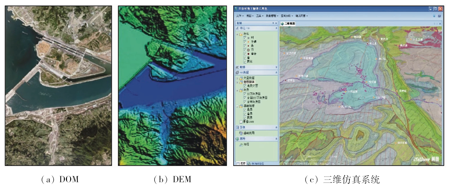
Wang Y, Zhang X K, Tong L Q. Development and application of a 3D simulation system based on remotely sensed information within Three Gorges Reservoir area[J]. Remote sensing information, 2012,27(04):40-43.
Chen J, Du L, Xiao C L, et al. DEM and DOM production without ground control points by POS-supported airborne LiDAR[J]. Geomatics & Spatial Infomation Technology, 2015,38(3):50-53.
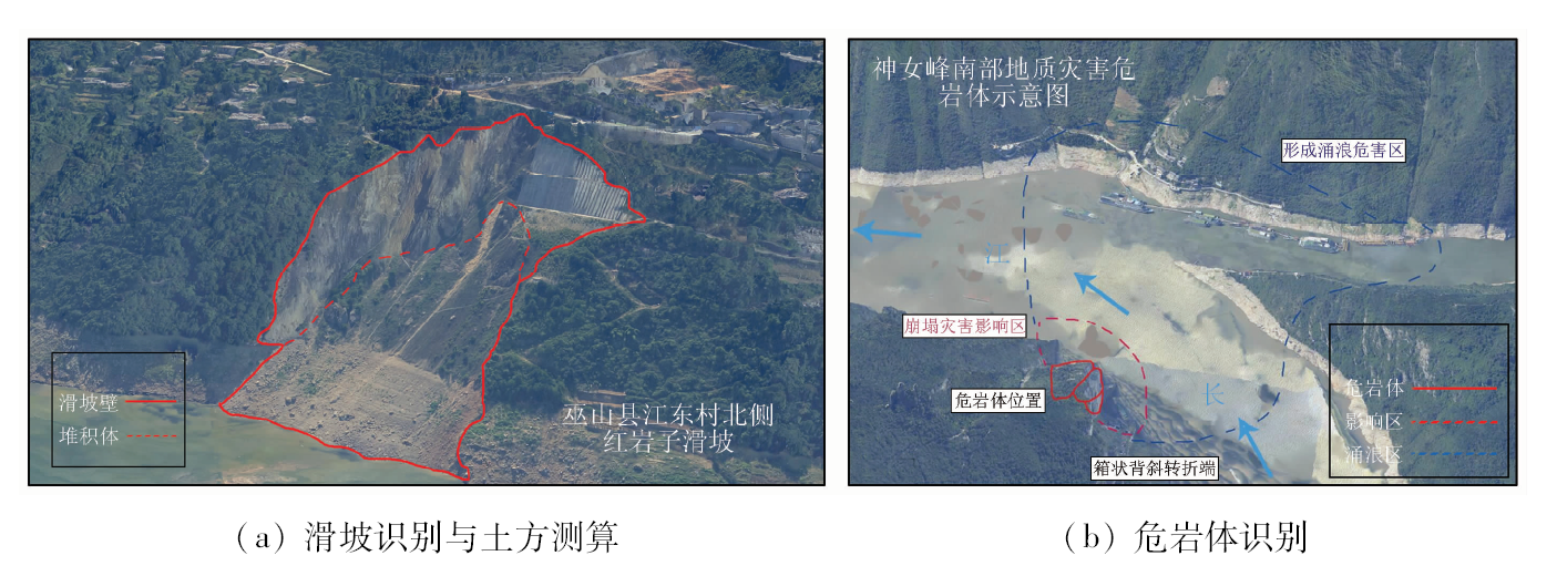
Liu S W, Guo D H, Chen W T, et al. The application of airborne lidar technology in landslide investigation and monitoring of Three Gorges Reservoir area[J]. Geology in China. 2012,39(2):507-517.
Du L, Chen J, Li M M, et al. The application of airborne LiDAR technology to landslide survey:A case study of Zhangjiawan Village landslides in Three Gorges Reservoir aera[J]. Remote Sensing for Land and Resources, 2019,31(1):180-186.doi: 10.6046/gtzyyg.2019.01.24.
[20]
李显巨. 基于LiDAR技术的复杂地质环境区滑坡识别研究[D]. 武汉:中国地质大学, 2012.
Li X J. Research of the landslide recognition based on LiDAR technology in the complex geological environment area[D]. Wuhan:China University of Geosciences, 2012.
Chen J, Li J, Du L, et al. Application and precision analysis of tight coupling direct georeferencing method[J].Bulletin of surveying and mapping, 2017(1):93-96,111.
Guo D H, Wu L X, Wang J C, et al. The application of IMU /DGPS-Supported photogrammetry[J].Remote Sensing for Land and Resources, 2006(1):51-55,74.doi: 10.6046/gtzyyg.2006.01.12.
[23]
庞剑波, 郑雄伟. 三峡库区首获航空遥感数据[J].山东国土资源, 2009(5):57.
Pang J B, Zheng X W. The first acquisition of airborne remote sensing data in the Three Gorges reservoir area[J].Shandong Land and Resources, 2009(5):57.
Guo D H, Wang J C, Zheng X W. Theory and practice of direct geolocation technology for airborne POS systems[M]. Beijing: Geological Publishing House, 2009.
[25]
王峰, 吴云东. 无人机遥感平台技术研究与应用[J].遥感信息, 2010(2):114-118.
Wang F, Wu Y D. Research on application of UAS borne remote sensing[J].Remote sensing infomation, 2010(2):114-118.
Yang J. Investigation and monitoring of multi axis unmanned aerial vehicle(UAV) with photographies in mass geological disasters in Three Gorges Reservoir region[J]. China’s Manganese Industry, 2017,35(1):147-151.
Zhang X H, Li X X, Li P. Review of GNSS PPP and its application[J]. Acta Geodaetica et Cartographica Sinica, 2017,46(10):1399-1407.
[30]
孙超. PPP后处理中卫星钟差内插方法研究[D]. 青岛:山东科技大学, 2011.
Sun C. Research on interpolation method of satellite clock error in PPP post processing[D]. Qingdao:Shandong University of Science and Technology, 2011.
 2020, Vol. 32