Oblique aerial photography technology and its application to geological survey:A case study of Wuxia section in the Three Gorges reservoir
CHEN Jie1,2(), CAI Jun3, LI Jing1, HE Peng1
1. China Aero Geophysical Survey & Remote Sensing Center for Natural Resources,Beijing 100083, China 2. Aerospace Information Research Institute, Chinese Academy of Sciences, Beijing 100094, China 3. Beijing Institute of Surveying and Mapping, Beijing 100038, China
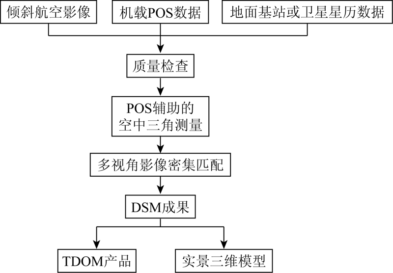
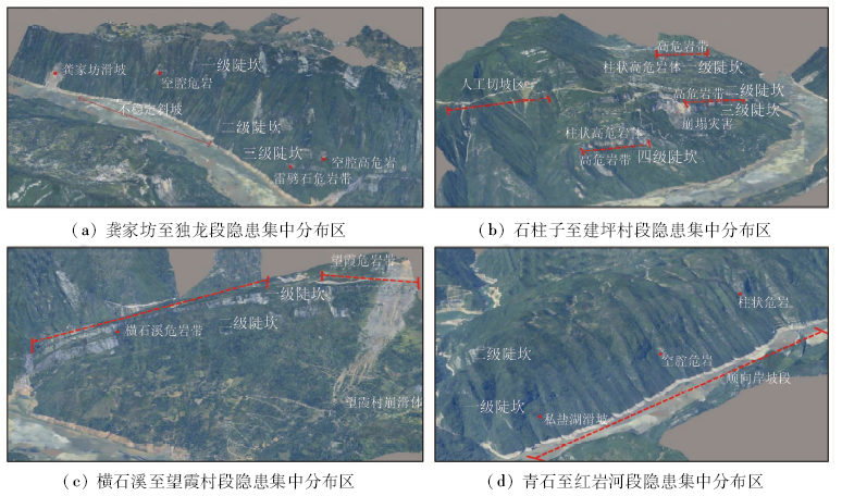
三峡库区巫峡段是滑坡和危岩崩塌的易发与多发地段,严重危及长江航道安全。倾斜航空摄影技术能精细刻画观测物的侧面纹理信息,为地质灾害隐患早期识别提供基础数据。文章在阐述和分析倾斜航空摄影技术的基础上,联合获取的倾斜航空影像、机载定位定姿系统(position and orientation system,POS)数据和地面控制点进行了三维模型制作,以地质、地貌、水文等因子建立地质灾害危险性评价模型,通过室内解译和野外调查基本查明了工作区内新发地质灾害发育情况及分布规律,摸清了各区域内控制地质灾害发生的主要因素,掌握了区内地质灾害易发性特征及灾害隐患情况。
The Wuxia section of the Three Gorges reservoir area is an area where landslides and dangerous rock collapses easily and frequently occur, which seriously endangers the safety of the Yangtze River channel. The oblique aerial photography technology can accurately describe the side texture information of the observed objects and provide basic data for the early identification of hidden dangers of geological hazards. In this paper, based on the elaboration and analysis of oblique aerial photography technology, the authors constructed three-dimensional models based on the acquired oblique aerial images, airborne position and orientation system (POS) data and ground control points, and established a geological hazard risk assessment model based on factors such as geology, geomorphology and hydrology. The development and distribution of new geological disasters in the work area were clarified, the main factors controlling the occurrence of geological disasters in each area were figured out, and the geological disasters susceptibility characteristics and hidden dangers in the area were grasped, thus the application potential of oblique aerial photography technology in geological survey was demonstrated.
陈洁, 蔡君, 李京, 贺鹏. 倾斜航空摄影技术及在地质调查中的应用研究——以三峡库区巫峡地区为例[J]. 国土资源遥感, 2021, 33(1): 167-173.
CHEN Jie, CAI Jun, LI Jing, HE Peng. Oblique aerial photography technology and its application to geological survey:A case study of Wuxia section in the Three Gorges reservoir. Remote Sensing for Land & Resources, 2021, 33(1): 167-173.
Li Y C. Stability of landslide under the effect of reservoir water in the area of Fuling of the Three Gorges reservoir area[D]. Chengdu:Chengdu University of Technology, 2016.
Ren S, Jiang D Y, Jiang Z W, et al. Monitoring technology of geological disaster in Three Gorges reservoir area and its prospect[J]. China Safety Science Journal, 2006(1):140-144,4.
He X, Wang J L, Chen H K, et al. Characteristics of geomorphic hazards in Wu Gorge bank slope and the mechanism for their development[J]. Journal of Southwest University (Natural Science), 2014,36(10):130-136.
Chen J, Gao Z H, Wang S S, et al. A review on the development of aerial remote sensing geological survey technology in the Three Gorges reservoir area[J]. Remote Sensing for Land and Resources, 2020,32(2):1-10.doi: 10.6046/gtzyyg.2020.02.01.
Jin D J, Wang J C, Wu F, et al. Aerial remote sensing technology and its applications in geological survey[J]. Remote Sensing for Land and Resources, 2019,31(4):1-10.doi: 10.6046/gtzyyg.2019.04.01.
[6]
李鸿祥. 三维城市规划辅助决策支持系统的设计与实现[D]. 厦门:厦门大学, 2013.
Li H X. Design and implementation of three-dimensional urban plan assisted decision-making system[D]. Xiamen:Xiamen University, 2013.
[7]
周杰. 倾斜摄影测量在实景三维建模中的关键技术研究[D]. 昆明:昆明理工大学, 2017.
Zhou J. Research on key technologies of oblique photogrammetry in 3D real scene modeling[D]. Kunming:Kunming University of Science and Technology, 2017.
Zhang F, Sang D K. Research and application of Leica RCD30 Oblique camera in 3D real city scene modeling[J]. Bulletin of Surveying and Mapping, 2017(2):153-157.
Zhang M, Wang D. Application of A3 digital aerial photography system in aerial photography[J]. Urban Geotechnical Investigation and Surveying, 2017(4):97-101.
Liu X. Research on urban rainstorm waterlogging simulation based on UAV tilt photogrammetry and SWMM[D]. Wuhan:Huazhong University of Science and Technology, 2019.
[11]
Zhang L, Gruen A. Multi-image matching for DSM generation from IKONOS imagery[J]. ISPRS Journal of Photogrammetry & Remote Sensing, 2006,60(3):195-211.
Ji S, Fan D Z, Zhang Y S, et al. Automatic DSM generation from three-line-array digital images based on AMMGC multiple-image matching model[J]. Science of Surveying & Mapping, 2009,34(2):139-141.
Dai C G, Jia X M, Shi X Y, et al. Multiple-view matching AMMGC optimization model for three-line-array images[J]. Journal of Geomatics Science and Technology, 2008,25(5):376-9.
[14]
Furukawa Y, Ponce J. Accurate,dense,and robust multiview stereopsis[J]. IEEE Transactions on Pattern Analysis & Machine Intelligence, 2010,32(8):1362-76.
doi: 10.1109/TPAMI.2009.161
pmid: 20558871
[15]
芦彦霖. 倾斜摄影测量实景三维模型构建及精度分析[D]. 徐州:中国矿业大学, 2019.
Lu Y L. Real-time 3D Model construction and precision analysis based on oblique photogrammetry[D]. Xuzhou:China University of Mining and Technology, 2019.
Liu Q. Application exploration of oblique photogrammetry in city planning[J]. Shanxi Architecture, 2017,43(22):203-205.
[17]
吕朋一. 三峡库区大宁河流域生态承载力研究[D]. 成都:成都理工大学, 2018.
Lyu P Y. Study on ecological carrying capacity of Daning River Basin in Three Gorges reservoir area[D]. Chengdu:Chengdu University of Technology, 2018.
General Administration of Quality Supervision, Inspection and Quarantine of the People’s Republic of China, Standardization Administration of the People’s Republic of China. GB/T 24236—2009 specifications for aerotriangulation of digital aerophotogrammetry[S]. China Standards Publishing House, 2009.
General Administration of Quality Supervision, Inspection and Quarantine of the People’s Republic of China, Standardization Administration of the People’s Republic of China. GB/T 24236—2009 specifications for aerotriangulation of digital aerophotogrammetry[S]. China Standards Publishing House, 2011.
Bi K, Zhao J X, Ding X B, et al. Technical design and product quality inspection of oblique aerial photography[J]. Bulletin of Surveying and Mapping, 2017(4):71-76.
Chen J, Yang D C, Du L, et al. Method for inspection of frame digital aerial photographic quality[J]. Remote Sensing for Land and Resources, 2014,26(4):91-96.doi: 10.6046/gtzyyg.2014.04.15.
Lin J, Wang S S. Report on aerial remote sensing geological survey in Three Gorges reservoir area[R]. China Aero Geophysical Survey & Remote Sensing Center for Natural Resources, 2018.
 2021, Vol. 33
  ), 蔡君3, 李京1, 贺鹏1